LiDAR 1m DTM Hillshade
Satellite Imagery
LiDAR 1m DTM Hillshade
Satellite Imagery
Scroll left/right to view further images.
HER: Devon MDV1669 (None)
NMR: SX 48 SE 5 (438139)
SM: 1104797
NGR: SX471804
X: 247104 Y: 80410 (OSGB36)
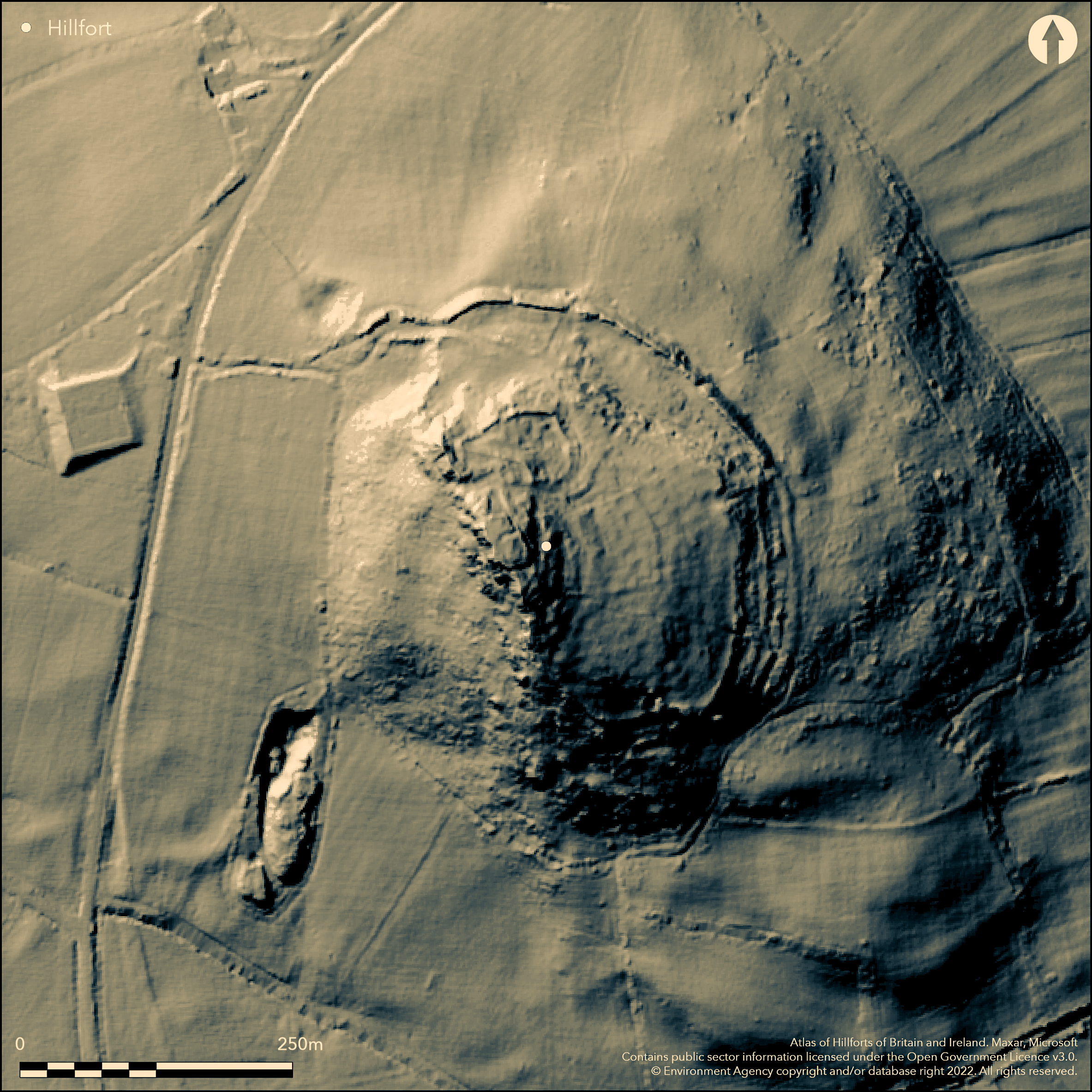
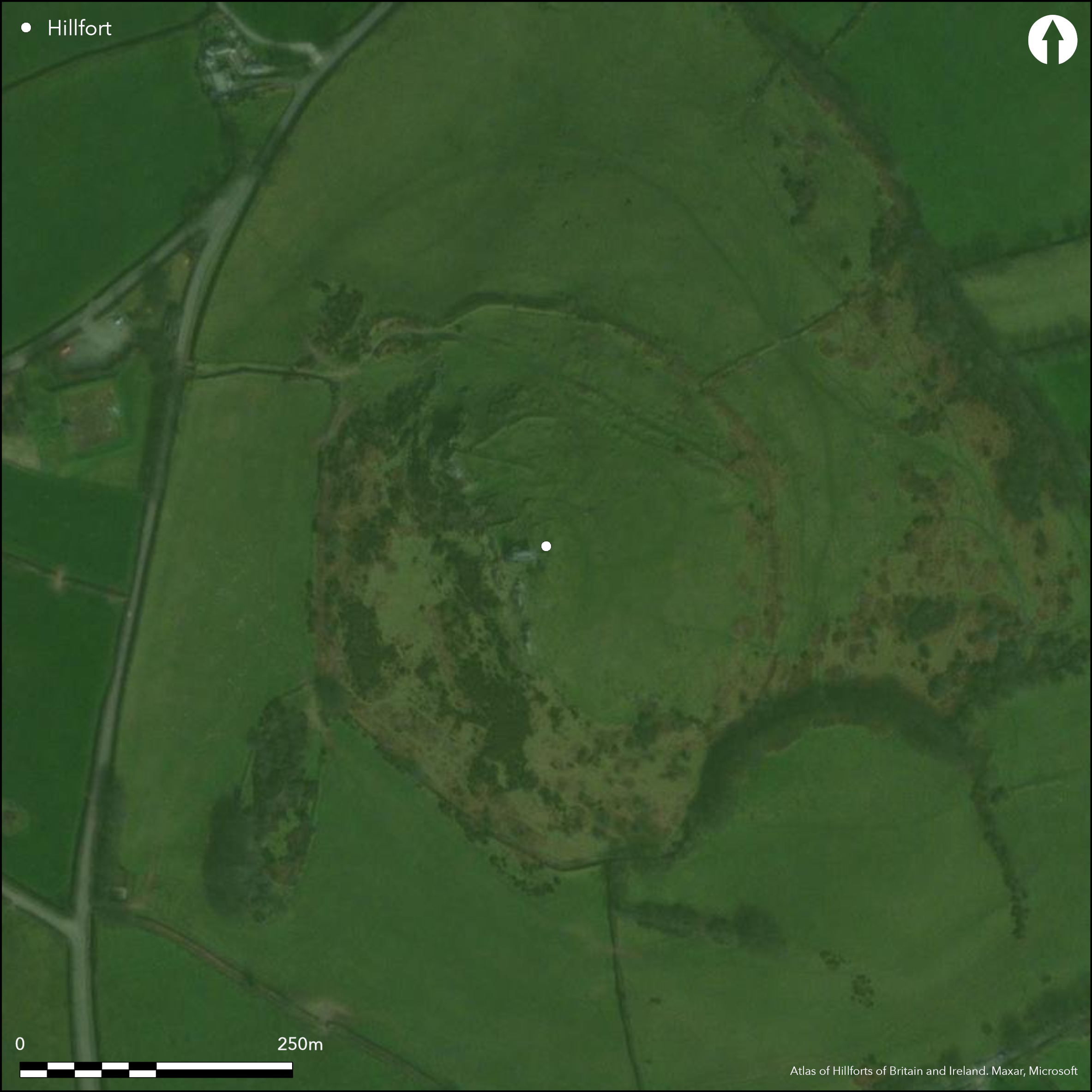
Possible contour hillfort located on rocky Brent Tor, conspicuous landmark on fringe of Dartmoor. Above River Burn to E. Curving, incomplete, rampart appears to enclose N and E sides of the tor, with precipitous outcrops providing definition on W. Wall/bank to 1m high on inside, but looking much steeper from without, with steep, apparently artificial, earthwork slope to 5m high and 10m wide at base. Possible traces of ditch in places. Possible structures behind rampart. Possible post medieval mineral extraction in interior confuses interpretation. Earthworks on N slopes of tor possibly Dark Age, medieval or later date and could be associated with fair held between 1231 and 1550. Hill subsequently used by abbots of Tavistock as site for Brentor parish church (St Michael's). Rocky grassland and bare rock.
Citizen Science: ✗
Reliability of Data: Unconfirmed
Reliability of Interpretation: Unconfirmed
X: -463316 Y: 6551413 (EPSG: 3857)
Longitude: -4.162038945726073 Latitude: 50.60326160498793 (EPSG:4326)
Country: England
Current County or Unitary Authority: Devon
Historic County: Devon
Current Parish/Community/Council/Townland: Brentor
Some management and erosion repair measures taken place. St Michael's Church in interior.
| Extant | ✓ |
| Cropmark | ✗ |
| Likely Destroyed | ✗ |
Rocky grassland and bare rock. Church in interior.
| Woodland | ✗ |
| Commercial Forestry Plantation | ✗ |
| Parkland | ✗ |
| Pasture (Grazing) | ✓ |
| Arable | ✗ |
| Scrub/Bracken | ✓ |
| Bare Outcrop | ✗ |
| Heather/Moorland | ✗ |
| Heath | ✗ |
| Built-up | ✓ |
| Coastal Grassland | ✗ |
| Other | ✗ |
Possible contour hillfort located on Brent Tor, conspicuous landmark on fringe of Dartmoor. Above River Burn to E.
| Contour Fort | ✓ |
| Partial Contour Fort | ✗ |
| Promontory Fort | ✗ |
| Hillslope Fort | ✗ |
| Level Terrain Fort | ✗ |
| Marsh Fort | ✗ |
| Multiple Enclosure Fort | ✗ |
| Hilltop | ✗ |
| Coastal Promontory | ✗ |
| Inland Promontory | ✗ |
| Valley Bottom | ✗ |
| Knoll/Hillock/Outcrop | ✓ |
| Ridge | ✗ |
| Cliff/Plateau-edge/Scarp | ✗ |
| Hillslope | ✗ |
| Lowland | ✗ |
| Spur | ✗ |
Dominant Topographic Feature: Rocky tor.
| North | ✗ |
| Northeast | ✗ |
| East | ✗ |
| Southeast | ✗ |
| South | ✗ |
| Southwest | ✗ |
| West | ✗ |
| Northwest | ✗ |
| Level | ✓ |
Altitude: 305.0m
N/A
Uncertain date. It is assumed that the site is Iron Age, but it is possible that it is earlier, even Neolithic.
Reliability: D - None
| Pre 1200BC | ✗ |
| 1200BC - 800BC | ✗ |
| 800BC - 400BC | ✗ |
| 400BC - AD50 | ✗ |
| AD50 - AD400 | ✗ |
| AD400 - AD 800 | ✗ |
| Post AD800 | ✗ |
| Unknown | ✓ |
| Pre Hillfort: | Possible. It is assumed that the site is Iron Age, but it is possible that it is earlier, even Neolithic. Flint chance find. |
| Post Hillfort: | None |
Earthwork survey - no details.
| Earthwork Survey (None): | No details. |
Earthwork foundations of c. dozen small rectilinear structures c. 4m by 3m extend for c. 70m along inside of highest rampart with c. ten contiguous structures c. 5m by 4m terraced into slope to SW. Flint chance find.
None
| None | ✓ |
| Spring | ✗ |
| Stream | ✗ |
| Pool | ✗ |
| Flush | ✗ |
| Well | ✗ |
| Other | ✗ |
Earthwork foundations of c. dozen small rectilinear structures c. 4m by 3m extend for c. 70m along inside of highest rampart with c. ten contiguous structures c. 5m by 4m terraced into slope to SW.
| No Known Features | ✗ |
| Round Stone Structures | ✗ |
| Rectangular Stone Structures | ✓ |
| Curvilinear Platforms | ✗ |
| Other Roundhouse Evidence | ✗ |
| Pits | ✗ |
| Quarry Hollows | ✗ |
| Other | ✗ |
None
| No Known Excavation | ✓ |
| Pits | ✗ |
| Postholes | ✗ |
| Roundhouses | ✗ |
| Rectangular Structures | ✗ |
| Roads/Tracks | ✗ |
| Quarry Hollows | ✗ |
| Other | ✗ |
| Nothing Found | ✗ |
None
| No Known Geophysics | ✓ |
| Pits | ✗ |
| Roundhouses | ✗ |
| Rectangular Structures | ✗ |
| Roads/Tracks | ✗ |
| Quarry Hollows | ✗ |
| Other | ✗ |
| Nothing Found | ✗ |
Flint chance find.
| No Known Finds | ✗ |
| Pottery | ✗ |
| Metal | ✗ |
| Metalworking | ✗ |
| Human Bones | ✗ |
| Animal Bones | ✗ |
| Lithics | ✓ |
| Environmental | ✗ |
| Other | ✗ |
None
| APs Not Checked | ✓ |
| None | ✗ |
| Roundhouses | ✗ |
| Rectangular Structures | ✗ |
| Pits | ✗ |
| Postholes | ✗ |
| Roads/Tracks | ✗ |
| Other | ✗ |
None defined.
| 0: | None |
| 2: | None |
Guard Chambers: ✗
Chevaux de Frise: ✗
Curving, incomplete, rampart appears to enclose N and E sides of the tor, with precipitous outcrops providing defence on W. Wall/bank to 1m high on inside, but looking much steeper from without, with steep, apparently artificial, earthwork slope to 5m high and 10m wide at base. Possible traces of ditch in places. Possible
| Area 1: | Noneha. |
| Total: | Noneha. |
Total Footprint Area: Noneha.
None
| ✗ | Area not defined. |
| ✗ | None |
| NE Quadrant: | 1 |
| SE Quadrant: | 1 |
| SW Quadrant: | 0 |
| NW Quadrant: | 0 |
| Total: | 1 |
| Partial Univallate | ✓ |
| Univallate | ✗ |
| Partial Bivallate | ✗ |
| Bivallate | ✗ |
| Partial Multivallate | ✗ |
| Multivallate | ✗ |
| Unknown | ✗ |
| Partial Univallate | ✗ |
| Univallate | ✗ |
| Partial Bivallate | ✗ |
| Bivallate | ✗ |
| Partial Multivallate | ✗ |
| Multivallate | ✗ |
Probable stone wall.
| None | ✗ |
| Earthen Bank | ✗ |
| Stone Wall | ✓ |
| Rubble | ✗ |
| Wall-walk | ✗ |
| Evidence of Timber | ✗ |
| Vitrification | ✗ |
| Other Burning | ✗ |
| Palisade | ✗ |
| Counter Scarp Bank | ✗ |
| Berm | ✗ |
| Unfinished | ✗ |
| Other | ✗ |
None
| None | ✗ |
| Earthen Bank | ✗ |
| Stone Wall | ✗ |
| Murus Duplex | ✗ |
| Timber-framed | ✗ |
| Timber-laced | ✗ |
| Vitrification | ✗ |
| Other Burning | ✗ |
| Palisade | ✗ |
| Counter Scarp Bank | ✗ |
| Berm | ✗ |
| Unfinished | ✗ |
| No Known Excavation | ✓ |
| Other | ✗ |
| ✗ | None |
| ✓ | Possible traces in places. |
Number of Ditches: 1
| ✗ | None |
Griffith, F. M. 1988. Devon's Past. An Aerial View. Devon's Past. An Aerial View, Paperback Volume, 66.
Newman, P. 2003. Brentor. An Earthwork Site on Western Dartmoor, Devon, English Heritage Archaeological Investigation Report, AI/12/2004.
Pilkington-Rogers, C. W. 1932. The Date of the Dartmoor Antiquities, Trans Devonshire Assoc, 64, 385.
Silvester, R. J. 1979. The Relationship of First Millennium Settlement to the Upland Areas of the South West, Proc Devon Archaeol Soc, 37, 181.
Worth, R. N.. 1889. Early History of Tavistock, Trans Devonshire Assoc. 21, 135.
Atlas of Hillforts:
Wikidata:
This work is licensed under CC BY-SA 4.0![]()
![]()
![]() and should be cited as:
and should be cited as:
Lock, Gary and Ralston, Ian. 2024. Atlas of Hillforts of Britain and Ireland. Available at: https://hillforts.arch.ox.ac.uk
Document Version 1.1