LiDAR 1m DTM Hillshade
Satellite Imagery
LiDAR 1m DTM Hillshade
Satellite Imagery
Scroll left/right to view further images.
HER: Cornwall and Scilly 5001 (None)
NMR: SX 05 NE 3 (431133)
SM: 1006663
NGR: SX 0590 5567
X: 205905 Y: 55681 (OSGB36)
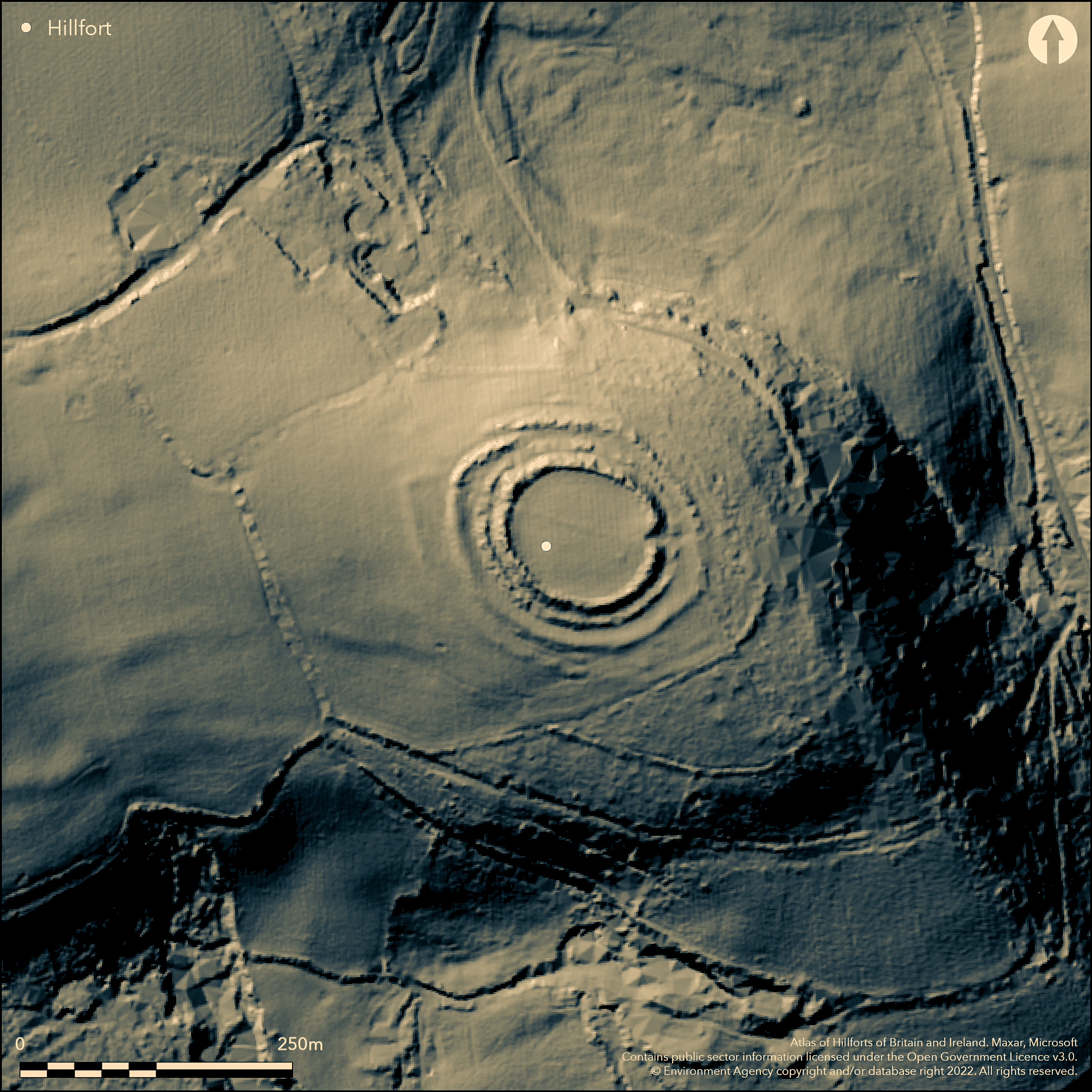
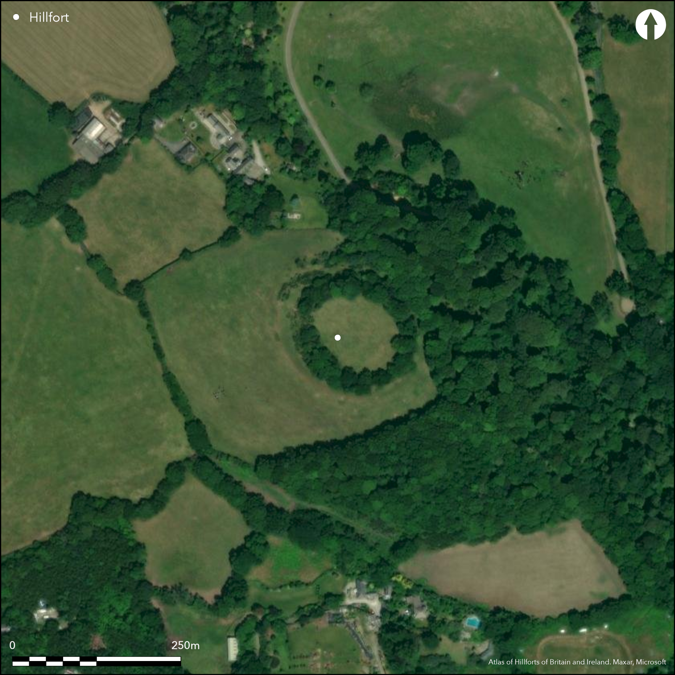
Possible small contour hillfort or round located at end of prominent SE-facing spur above streams on E flowing into St Austell Bay on S. Steep slopes, moderate along ridge on NW. Roughly circular enclosing c. 0.81ha. Defined by three closely-spaced concentric ramparts and ditches, with incomplete fourth or more likely counterscarp on W. Ramparts range 1.3m to 2.7m, high inner best, outermost as partial scarp to 1.3m high. Possible staggered entrance on W, but no obvious break in third rampart, that on E possibly later. On N and E circuit overlain by field boundaries. Circular depression, 0.5m deep, outside fourth rampart on E side possible round house or small quarry. Chance finds of numerous flints, slingstones, stone axe and sherd of South-West Decorated pottery from interior. Pasture interior, wooded banks and Warren Wood to E and S. On 1st Ed. OS map (1882).
Citizen Science: ✗
Reliability of Data: Confirmed
Reliability of Interpretation: Unconfirmed
X: -526627 Y: 6510404 (EPSG: 3857)
Longitude: -4.730769510776646 Latitude: 50.36886973021853 (EPSG:4326)
Country: England
Current County or Unitary Authority: Cornwall
Historic County: Cornwall
Current Parish/Community/Council/Townland: Luxulyan
Fair condition.
| Extant | ✓ |
| Cropmark | ✗ |
| Likely Destroyed | ✗ |
Pasture interior, wooded banks and Warren Wood to E and S.
| Woodland | ✓ |
| Commercial Forestry Plantation | ✗ |
| Parkland | ✗ |
| Pasture (Grazing) | ✓ |
| Arable | ✗ |
| Scrub/Bracken | ✗ |
| Bare Outcrop | ✗ |
| Heather/Moorland | ✗ |
| Heath | ✗ |
| Built-up | ✗ |
| Coastal Grassland | ✗ |
| Other | ✗ |
Possible small contour hillfort or round located at end of prominent SE-facing spur above streams on E flowing into St Austell Bay on S. Steep slopes, moderate along ridge on NW.
| Contour Fort | ✓ |
| Partial Contour Fort | ✗ |
| Promontory Fort | ✗ |
| Hillslope Fort | ✗ |
| Level Terrain Fort | ✗ |
| Marsh Fort | ✗ |
| Multiple Enclosure Fort | ✗ |
| Hilltop | ✗ |
| Coastal Promontory | ✗ |
| Inland Promontory | ✗ |
| Valley Bottom | ✗ |
| Knoll/Hillock/Outcrop | ✗ |
| Ridge | ✗ |
| Cliff/Plateau-edge/Scarp | ✗ |
| Hillslope | ✗ |
| Lowland | ✗ |
| Spur | ✓ |
Dominant Topographic Feature: Spur
| North | ✗ |
| Northeast | ✗ |
| East | ✗ |
| Southeast | ✗ |
| South | ✗ |
| Southwest | ✗ |
| West | ✗ |
| Northwest | ✗ |
| Level | ✓ |
Altitude: 125.0m
N/A
Numerous chance finds of slingstones, stone axe and sherd of South-West Decorated pottery suggest Iron Age date.
Reliability: C - Low
| Pre 1200BC | ✗ |
| 1200BC - 800BC | ✗ |
| 800BC - 400BC | ✗ |
| 400BC - AD50 | ✓ |
| AD50 - AD400 | ✗ |
| AD400 - AD 800 | ✗ |
| Post AD800 | ✗ |
| Unknown | ✗ |
| Pre Hillfort: | None |
| Post Hillfort: | None |
| Artefactual: | Chance finds. |
Investigations Ordnance Survey 1813, 1969. Mention Lysons, D. and Lysons, S. Magna Britannia 1814. On 1st Ed. OS map (1882). Field investigation Ordnance Survey 1969. Aerial photograph interpretation Cornwall NMP. Survey Cornwall Archaeological Unit as part of the Luxulyan Valley Project 1988. Assessment Cornwall Archaeological Unit 1998.
| 1st Identified Map Depiction (1813): | Investigations OS. |
| 1st Identified Written Reference (1814): | Mention Lysons, D. and Lysons, S. Magna Britannia. |
| Other (1882): | OS map. |
| Other (1969): | Field investigation OS. |
| Other (1988): | Survey Cornwall Archaeological Unit as part of the Luxulyan Valley Project. |
| Other (1998): | Assessment Cornwall Archaeological Unit. |
| Other (None): | Aerial photograph interpretation Cornwall NMP. |
Hut circle. Chance finds of numerous flints, slingstones, stone axe and sherd of South-West Decorated pottery.
None
| None | ✓ |
| Spring | ✗ |
| Stream | ✗ |
| Pool | ✗ |
| Flush | ✗ |
| Well | ✗ |
| Other | ✗ |
Possible hut circle (or quarry depression).
| No Known Features | ✗ |
| Round Stone Structures | ✗ |
| Rectangular Stone Structures | ✗ |
| Curvilinear Platforms | ✗ |
| Other Roundhouse Evidence | ✓ |
| Pits | ✗ |
| Quarry Hollows | ✗ |
| Other | ✗ |
None
| No Known Excavation | ✓ |
| Pits | ✗ |
| Postholes | ✗ |
| Roundhouses | ✗ |
| Rectangular Structures | ✗ |
| Roads/Tracks | ✗ |
| Quarry Hollows | ✗ |
| Other | ✗ |
| Nothing Found | ✗ |
None
| No Known Geophysics | ✓ |
| Pits | ✗ |
| Roundhouses | ✗ |
| Rectangular Structures | ✗ |
| Roads/Tracks | ✗ |
| Quarry Hollows | ✗ |
| Other | ✗ |
| Nothing Found | ✗ |
Chance finds of numerous flints, slingstones, stone axe and sherd of South-West Decorated pottery.
| No Known Finds | ✗ |
| Pottery | ✓ |
| Metal | ✗ |
| Metalworking | ✗ |
| Human Bones | ✗ |
| Animal Bones | ✗ |
| Lithics | ✓ |
| Environmental | ✗ |
| Other | ✗ |
None
| APs Not Checked | ✓ |
| None | ✗ |
| Roundhouses | ✗ |
| Rectangular Structures | ✗ |
| Pits | ✗ |
| Postholes | ✗ |
| Roads/Tracks | ✗ |
| Other | ✗ |
Possible staggered entrance on W, but no obvious break in third rampart, that on E possibly later.
| 2: | E possibly modern. |
| 2: | None |
Guard Chambers: ✗
Chevaux de Frise: ✗
| 1. Over-lapping (West): | None |
Defined by three closely-spaced concentric ramparts and ditches, with incomplete fourth or more likely counterscarp on W. Ramparts range 1.3m to 2.7m, high inner best, outermost as partial scarp to 1.3m high.
| Area 1: | 0.81ha. |
| Total: | 0.81ha. |
Total Footprint Area: Noneha.
None
| ✗ | None |
| ✓ | Fourth bank on W may be countercarp, but uncertain. |
| NE Quadrant: | 3 |
| SE Quadrant: | 3 |
| SW Quadrant: | 3 |
| NW Quadrant: | 3 |
| Total: | 3 |
| Partial Univallate | ✗ |
| Univallate | ✗ |
| Partial Bivallate | ✗ |
| Bivallate | ✗ |
| Partial Multivallate | ✗ |
| Multivallate | ✓ |
| Unknown | ✗ |
| Partial Univallate | ✗ |
| Univallate | ✗ |
| Partial Bivallate | ✗ |
| Bivallate | ✗ |
| Partial Multivallate | ✗ |
| Multivallate | ✗ |
Fourth bank more likely counterscarp, but uncertain.
| None | ✗ |
| Earthen Bank | ✓ |
| Stone Wall | ✗ |
| Rubble | ✗ |
| Wall-walk | ✗ |
| Evidence of Timber | ✗ |
| Vitrification | ✗ |
| Other Burning | ✗ |
| Palisade | ✗ |
| Counter Scarp Bank | ✓ |
| Berm | ✗ |
| Unfinished | ✗ |
| Other | ✗ |
None
| None | ✗ |
| Earthen Bank | ✗ |
| Stone Wall | ✗ |
| Murus Duplex | ✗ |
| Timber-framed | ✗ |
| Timber-laced | ✗ |
| Vitrification | ✗ |
| Other Burning | ✗ |
| Palisade | ✗ |
| Counter Scarp Bank | ✗ |
| Berm | ✗ |
| Unfinished | ✗ |
| No Known Excavation | ✓ |
| Other | ✗ |
| ✗ | None |
| ✓ | Total number of ditches estimated depending on whether fourth bank is counterscarp or not. |
Number of Ditches: 3
| ✗ | None |
Henderson, C. 1914. Notebooks of Parochial Antiquities, MS At RIC. Vol 3, 320.
Lysons, D. and Lysons, S. 1814. Magna Britannia, Vol III, Cornwall, 247.
Page, W. ed. 1906. The Victoria history of the County of Cornwall, Vol I, 462, The Victoria History of the Counties of England.
Smith, J.R. 1998. Prideaux Wood, Luxulyan: an archaeological assessment, Unpublished monograph Cornwall County Council, Cornwall Archaeological Unit.
Atlas of Hillforts:
Wikidata:
This work is licensed under CC BY-SA 4.0![]()
![]()
![]() and should be cited as:
and should be cited as:
Lock, Gary and Ralston, Ian. 2024. Atlas of Hillforts of Britain and Ireland. Available at: https://hillforts.arch.ox.ac.uk
Document Version 1.1