Satellite Imagery
Satellite Imagery
HER: Isle of Man 450 (None)
NMR: None (None)
SM: None
NGR: SC392941
X: 239200 Y: 494100 (OSGB36)
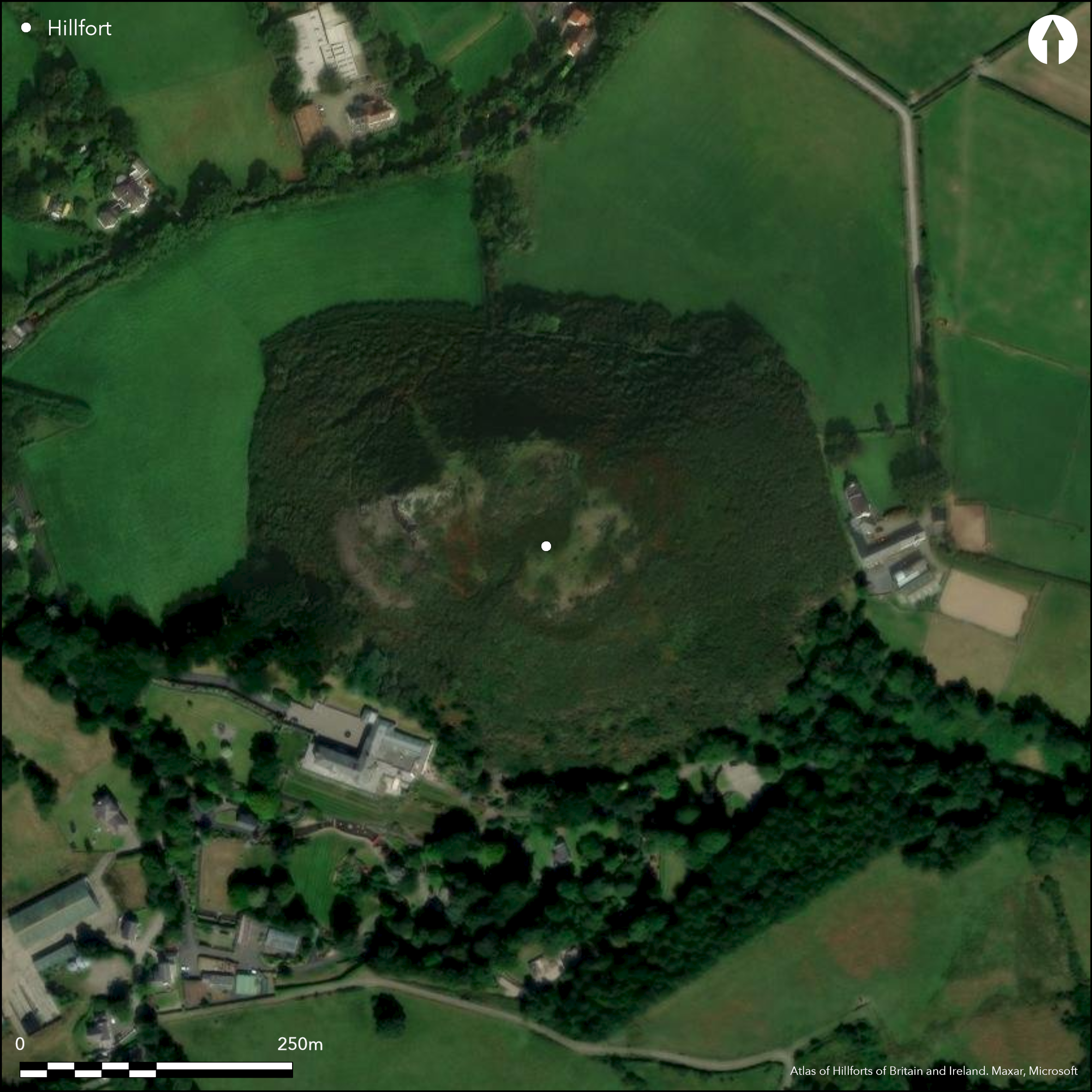
Interesting and complex, commanding, partial contour hillfort located on prominent rocky outcrop above bend of the Sulby River with extensive views across island coastal plain to NE to Point of Ayre and NW to Jurby Head. Very steep surrounding slopes, precipitous on N and W ramparts only necessary on E and S. Defined by two summits to hilltop, to NE and SW, within outer ramparts. NE summit has bank, almost square in form 20m by 20m, with 3m wide entrance on NE. None defined elsewhere. Between this enclosure and the SW summit are three ditches and two banks, that to the W the strongest and partly enclosing the SW summit. This ditch is 3m wide and 1.5m deep, with no causeway. Here the inner bank shows evidence of vitrification. The outer ramparts have recently been part-re-interpreted by LiDar and field visit by the Centre for Manx Studies, University of Liverpool, since Cotton's description of the site in 1954. A substantial outer rampart on the S skirts the site downslope, its N portion now suggested as an historic Manx field bank; the S part, however, although heavily eroded, probably original and enclosing an outer enclosure on the S. Upslope from this, another rampart is set below a natural slope which may have been scarped to create a terrace area immediately behind and a suitable site for potential roundhouses. An additional rampart possible further upslope, running around the top of this scarp, but bare rock does not aid identification and caution necessary. Rough upland pasture, gorse scrub and bare rock. Difficult to interpret because of scrub, but heavily eroded. On 1st Ed. OS map (1869). Undated.
Citizen Science: ✗
Reliability of Data: Confirmed
Reliability of Interpretation: Confirmed
X: -498005 Y: 7230441 (EPSG: 3857)
Longitude: -4.473657253111441 Latitude: 54.317098946145 (EPSG:4326)
Country: Isle of Man
Current County or Unitary Authority: Ayre
Historic County: Ayrshire
Current Parish/Community/Council/Townland: Lezayre
Difficult to interpret because of scrub, but heavily eroded.
| Extant | ✓ |
| Cropmark | ✗ |
| Likely Destroyed | ✗ |
Rough upland pasture, gorse scrub and bare rock.
| Woodland | ✗ |
| Commercial Forestry Plantation | ✗ |
| Parkland | ✗ |
| Pasture (Grazing) | ✓ |
| Arable | ✗ |
| Scrub/Bracken | ✓ |
| Bare Outcrop | ✗ |
| Heather/Moorland | ✗ |
| Heath | ✗ |
| Built-up | ✗ |
| Coastal Grassland | ✗ |
| Other | ✗ |
Interesting and complex, commanding, partial contour hillfort located on two summits of prominent rocky outcrop above a bend of the the Sulby River to N and Wwith extensive views across island coastal plain to NE to Point of Ayre and NW to Jurby Head. Very steep surrounding slopes, precipitous on N and W.
| Contour Fort | ✗ |
| Partial Contour Fort | ✓ |
| Promontory Fort | ✗ |
| Hillslope Fort | ✗ |
| Level Terrain Fort | ✗ |
| Marsh Fort | ✗ |
| Multiple Enclosure Fort | ✗ |
| Hilltop | ✓ |
| Coastal Promontory | ✗ |
| Inland Promontory | ✗ |
| Valley Bottom | ✗ |
| Knoll/Hillock/Outcrop | ✗ |
| Ridge | ✗ |
| Cliff/Plateau-edge/Scarp | ✗ |
| Hillslope | ✗ |
| Lowland | ✗ |
| Spur | ✗ |
Dominant Topographic Feature: Two summits to hilltop
| North | ✗ |
| Northeast | ✗ |
| East | ✗ |
| Southeast | ✗ |
| South | ✗ |
| Southwest | ✗ |
| West | ✗ |
| Northwest | ✗ |
| Level | ✓ |
Altitude: 76.0m
N/A
None.
Reliability: D - None
| Pre 1200BC | ✗ |
| 1200BC - 800BC | ✗ |
| 800BC - 400BC | ✗ |
| 400BC - AD50 | ✗ |
| AD50 - AD400 | ✗ |
| AD400 - AD 800 | ✗ |
| Post AD800 | ✗ |
| Unknown | ✓ |
| Pre Hillfort: | None |
| Post Hillfort: | None |
On 1st Ed. OS map (1869). Investigated by M.A. Cotton (with B.R.S. Megaw) 1954. Recent LiDar survey Centre for Manx Studies, University of Liverpool c. 2013.
| 1st Identified Map Depiction (1869): | OS map. |
| Other (1954): | Investigated by M.A. Cotton (with B.R.S. Megaw). |
| Other (1995): | Visited by Hillfort Study Group |
| Other (2015): | Visited by Hillfort Study Group |
| LiDAR Survey (None): | Centre for Manx Studies, University of Liverpool. |
Upslope from outer rampart, another rampart is set below a natural slope which may have been scarped to create a terrace area immediately behind and a suitable for potential roundhouses.
None
| None | ✓ |
| Spring | ✗ |
| Stream | ✗ |
| Pool | ✗ |
| Flush | ✗ |
| Well | ✗ |
| Other | ✗ |
Upslope from outer rampart, another rampart is set below a natural slope which may have been scarped to create a terrace area immediately behind and a suitable for potential roundhouses.
| No Known Features | ✗ |
| Round Stone Structures | ✗ |
| Rectangular Stone Structures | ✗ |
| Curvilinear Platforms | ✗ |
| Other Roundhouse Evidence | ✗ |
| Pits | ✗ |
| Quarry Hollows | ✗ |
| Other | ✓ |
None
| No Known Excavation | ✓ |
| Pits | ✗ |
| Postholes | ✗ |
| Roundhouses | ✗ |
| Rectangular Structures | ✗ |
| Roads/Tracks | ✗ |
| Quarry Hollows | ✗ |
| Other | ✗ |
| Nothing Found | ✗ |
None
| No Known Geophysics | ✓ |
| Pits | ✗ |
| Roundhouses | ✗ |
| Rectangular Structures | ✗ |
| Roads/Tracks | ✗ |
| Quarry Hollows | ✗ |
| Other | ✗ |
| Nothing Found | ✗ |
None
| No Known Finds | ✓ |
| Pottery | ✗ |
| Metal | ✗ |
| Metalworking | ✗ |
| Human Bones | ✗ |
| Animal Bones | ✗ |
| Lithics | ✗ |
| Environmental | ✗ |
| Other | ✗ |
None
| APs Not Checked | ✓ |
| None | ✗ |
| Roundhouses | ✗ |
| Rectangular Structures | ✗ |
| Pits | ✗ |
| Postholes | ✗ |
| Roads/Tracks | ✗ |
| Other | ✗ |
NE summit defended by bank, almost square in form 20m by 20m, with 3m wide gap entrance on NE. None defined elsewhere.
| 1: | None |
| 2: | None |
Guard Chambers: ✗
Chevaux de Frise: ✗
| 1. Simple Gap (North east): | Entrance to NE summit enclosure. |
NE summit defended by bank, almost square in form 20m by 20m. Between this enclosure and the SW summit are three ditches and two banks, that to the W the strongest and partly enclosing the SW summit. This ditch is 3m wide and 1.5m deep, with no causeway. Here the inner bank shows evidence of vitrification. A substantial outer rampart on the S skirts the site downslope, its N portion now suggested as an historic Manx field bank; the S part, however, although heavily eroded, probably original and enclosing an outer enclosure on the S. Upslope from this, another rampart is set below a natural slope which may have been scarped to create a terrace area. An additional rampart possible further upslope still, running around the top of this scarp.
| Area 1: | Noneha. |
| Total: | Noneha. |
Total Footprint Area: Noneha.
None
| ✗ | Area not defined. |
| ✓ | Circuit complex and difficult to define. |
| NE Quadrant: | 4 |
| SE Quadrant: | 2 |
| SW Quadrant: | 2 |
| NW Quadrant: | 3 |
| Total: | 4 |
| Partial Univallate | ✗ |
| Univallate | ✗ |
| Partial Bivallate | ✓ |
| Bivallate | ✗ |
| Partial Multivallate | ✓ |
| Multivallate | ✗ |
| Unknown | ✗ |
| Partial Univallate | ✗ |
| Univallate | ✗ |
| Partial Bivallate | ✗ |
| Bivallate | ✗ |
| Partial Multivallate | ✗ |
| Multivallate | ✗ |
Inner bank between two summits shows evidence of vitrification.
| None | ✗ |
| Earthen Bank | ✓ |
| Stone Wall | ✗ |
| Rubble | ✗ |
| Wall-walk | ✗ |
| Evidence of Timber | ✗ |
| Vitrification | ✓ |
| Other Burning | ✗ |
| Palisade | ✗ |
| Counter Scarp Bank | ✗ |
| Berm | ✗ |
| Unfinished | ✗ |
| Other | ✗ |
None
| None | ✗ |
| Earthen Bank | ✗ |
| Stone Wall | ✗ |
| Murus Duplex | ✗ |
| Timber-framed | ✗ |
| Timber-laced | ✗ |
| Vitrification | ✗ |
| Other Burning | ✗ |
| Palisade | ✗ |
| Counter Scarp Bank | ✗ |
| Berm | ✗ |
| Unfinished | ✗ |
| No Known Excavation | ✓ |
| Other | ✗ |
| ✗ | None |
| ✓ | Three ditches between two summits. |
Number of Ditches: 3
| ✗ | None |
Cotton, M.A. 1954. Vitrified forts and the camp on Cronk Sumark, with supplementary notes by B.R.S. Megaw, Proc Isle of Man Nat Hist Antiq Soc, 5.2, 189-194.
Atlas of Hillforts:
Wikidata:
This work is licensed under CC BY-SA 4.0![]()
![]()
![]() and should be cited as:
and should be cited as:
Lock, Gary and Ralston, Ian. 2024. Atlas of Hillforts of Britain and Ireland. Available at: https://hillforts.arch.ox.ac.uk
Document Version 1.1