Satellite Imagery
Satellite Imagery
HER: Isle of Man 229 (None)
NMR: None (None)
SM: None
NGR: SC45099578
X: 245090 Y: 495780 (OSGB36)
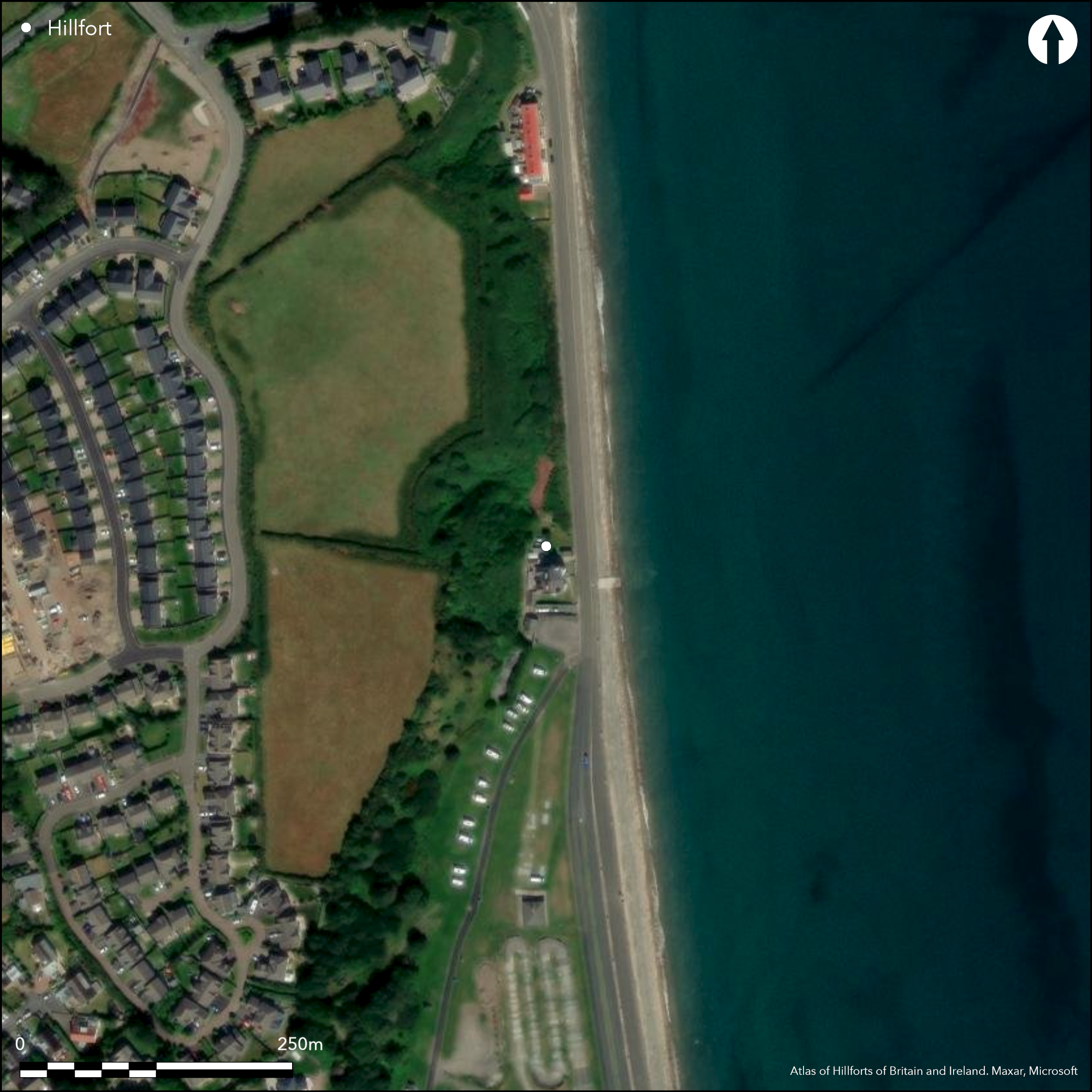
Possible, small, coastal promontory fort located on E-facing promontory above shore of Ramsey Bay on the brooghs, which form E edge of undulating Andreas Plateau towards the sea. Development, quarrying for sand, gravel and marl, and road now reduced promontory, fort formerly relying on sea for definition on E, with wide and deep gullies to N and S also protect site, with only rampart formerly across narrow neck landward on W. This now much mutilated by drainage ditches and hedge bank, making any archaeology unrecognisable now and probably destroyed. First fort to be excavated on island by G. Bersu 1946, who also found ramparts virtually destroyed, with only possible ditch traces on W, but remains of six, rectilinear, timber buildings, all with cooking hearths, with charcoal, grey ash mixed with fragments of burnt lay and calcined (animal?) bone splinters, in evidence. Entrance doors were feature with suggestion of only light roof cover and temporary occupation. Possibly, by analogy, Viking, 9th century or later. Much scrub (brambles, gorse, bracken, some blackthorn). On 1st Ed. OS map (1870). The site is now overgrown, but inspection since Bersu's excavation has failed to find traces of the bank surrounding the promontory surveyed by the Ordnance Survey in 1869. Any landward ditch has been damaged or obscured by the later track which led to a 19th century marl pit just to S. Quarrying would appear to have reduced the extent of the promontory, even since the 1869 Survey.
Citizen Science: ✗
Reliability of Data: Unconfirmed
Reliability of Interpretation: Unconfirmed
X: -488032 Y: 7233669 (EPSG: 3857)
Longitude: -4.3840649694158325 Latitude: 54.33400648513099 (EPSG:4326)
Country: Isle of Man
Current County or Unitary Authority: Ayre
Historic County: Ayrshire
Current Parish/Community/Council/Townland: Lezayre
Inaccessible (2011) and ramparts on E probably destroyed.
| Extant | ✗ |
| Cropmark | ✗ |
| Likely Destroyed | ✓ |
Much scrub (brambles, gorse, bracken, some blackthorn).
| Woodland | ✗ |
| Commercial Forestry Plantation | ✗ |
| Parkland | ✗ |
| Pasture (Grazing) | ✗ |
| Arable | ✗ |
| Scrub/Bracken | ✓ |
| Bare Outcrop | ✗ |
| Heather/Moorland | ✗ |
| Heath | ✗ |
| Built-up | ✗ |
| Coastal Grassland | ✗ |
| Other | ✗ |
Possible, small, coastal promontory fort located on E-facing promontory above shore of Ramsey Bay on the brooghs, which form E edge of undulating Andreas Plateau towards the sea.
| Contour Fort | ✗ |
| Partial Contour Fort | ✗ |
| Promontory Fort | ✓ |
| Hillslope Fort | ✗ |
| Level Terrain Fort | ✗ |
| Marsh Fort | ✗ |
| Multiple Enclosure Fort | ✗ |
| Hilltop | ✗ |
| Coastal Promontory | ✓ |
| Inland Promontory | ✗ |
| Valley Bottom | ✗ |
| Knoll/Hillock/Outcrop | ✗ |
| Ridge | ✗ |
| Cliff/Plateau-edge/Scarp | ✗ |
| Hillslope | ✗ |
| Lowland | ✗ |
| Spur | ✗ |
Dominant Topographic Feature: Coastal promontory
| North | ✗ |
| Northeast | ✗ |
| East | ✗ |
| Southeast | ✗ |
| South | ✗ |
| Southwest | ✗ |
| West | ✗ |
| Northwest | ✗ |
| Level | ✓ |
Altitude: 15.0m
N/A
Date unknown, but buildings, by analogy, Viking, 9th century or later.
Reliability: C - Low
| Pre 1200BC | ✗ |
| 1200BC - 800BC | ✗ |
| 800BC - 400BC | ✗ |
| 400BC - AD50 | ✗ |
| AD50 - AD400 | ✗ |
| AD400 - AD 800 | ✗ |
| Post AD800 | ✓ |
| Unknown | ✗ |
| Pre Hillfort: | None |
| Post Hillfort: | None |
Castle Rushen papers 1719 reference. On 1st Ed. OS map (1870). Ordnance Survey investigation 1957. Field survey J. Woodcock 1999. Field visit University of Liverpool 2011.
| 1st Identified Written Reference (1719): | Castle Rushen papers reference. |
| 1st Identified Map Depiction (1870): | OS map. |
| Excavation (1946): | G. Bersu. |
| Other (1955): | OS survey. |
| Other (1999): | Field survey J. Woodcok. |
| Other (2011): | Field visit University of Liverpool. |
Posthole evidence of six, rectilinear with rounded corners, lightweight timber buildings, with central aisle and walls of withies, but no daub or clay found. Varied in size from 3.9m by 7.8m to 5.4m by 9.8m. All with unlined cooking pits or hearths and charcoal, grey ash mixed with fragments of burnt lay and calcined (animal?) bone splinters, in evidence. Buildings superimposed one upon other with little time lapse between construction.
None
| None | ✓ |
| Spring | ✗ |
| Stream | ✗ |
| Pool | ✗ |
| Flush | ✗ |
| Well | ✗ |
| Other | ✗ |
None
| No Known Features | ✓ |
| Round Stone Structures | ✗ |
| Rectangular Stone Structures | ✗ |
| Curvilinear Platforms | ✗ |
| Other Roundhouse Evidence | ✗ |
| Pits | ✗ |
| Quarry Hollows | ✗ |
| Other | ✗ |
Posthole evidence of six, rectilinear with rounded corners, lightweight timber buildings, with central aisle and walls of withies, but no daub or clay found. Varied in size from 3.9m by 7.8m to 5.4m by 9.8m. All with unlined hearths and charcoal, grey ash mixed with fragments of burnt lay and calcined (animal?) bone splinters, in evidence. Buildings superimposed one upon other with little time lapse between construction.
| No Known Excavation | ✗ |
| Pits | ✗ |
| Postholes | ✓ |
| Roundhouses | ✗ |
| Rectangular Structures | ✓ |
| Roads/Tracks | ✗ |
| Quarry Hollows | ✗ |
| Other | ✓ |
| Nothing Found | ✗ |
None
| No Known Geophysics | ✓ |
| Pits | ✗ |
| Roundhouses | ✗ |
| Rectangular Structures | ✗ |
| Roads/Tracks | ✗ |
| Quarry Hollows | ✗ |
| Other | ✗ |
| Nothing Found | ✗ |
Charcoal, grey ash mixed with fragments of burnt lay and calcined (animal?) bone splinters, in evidence.
| No Known Finds | ✗ |
| Pottery | ✗ |
| Metal | ✗ |
| Metalworking | ✗ |
| Human Bones | ✗ |
| Animal Bones | ✓ |
| Lithics | ✗ |
| Environmental | ✓ |
| Other | ✗ |
None
| APs Not Checked | ✓ |
| None | ✗ |
| Roundhouses | ✗ |
| Rectangular Structures | ✗ |
| Pits | ✗ |
| Postholes | ✗ |
| Roads/Tracks | ✗ |
| Other | ✗ |
None visible. Probably destroyed.
| 0: | None |
| 2: | None |
Guard Chambers: ✗
Chevaux de Frise: ✗
Only artificial defence formerly across narrow neck landward on W. This now much mutilated by drainage ditches and hedge bank making any archaeology unrecognisable now and probably destroyed. Bersu also found defences virtually destroyed, with only possible ditch traces on W.
| Area 1: | Noneha. |
| Total: | Noneha. |
Total Footprint Area: Noneha.
None
| ✗ | Area not defined. |
| ✗ | Probably destroyed. |
| NE Quadrant: | None |
| SE Quadrant: | None |
| SW Quadrant: | None |
| NW Quadrant: | None |
| Total: | None |
| Partial Univallate | ✗ |
| Univallate | ✗ |
| Partial Bivallate | ✗ |
| Bivallate | ✗ |
| Partial Multivallate | ✗ |
| Multivallate | ✗ |
| Unknown | ✓ |
| Partial Univallate | ✗ |
| Univallate | ✗ |
| Partial Bivallate | ✗ |
| Bivallate | ✗ |
| Partial Multivallate | ✗ |
| Multivallate | ✗ |
None
| None | ✓ |
| Earthen Bank | ✗ |
| Stone Wall | ✗ |
| Rubble | ✗ |
| Wall-walk | ✗ |
| Evidence of Timber | ✗ |
| Vitrification | ✗ |
| Other Burning | ✗ |
| Palisade | ✗ |
| Counter Scarp Bank | ✗ |
| Berm | ✗ |
| Unfinished | ✗ |
| Other | ✗ |
None
| None | ✓ |
| Earthen Bank | ✗ |
| Stone Wall | ✗ |
| Murus Duplex | ✗ |
| Timber-framed | ✗ |
| Timber-laced | ✗ |
| Vitrification | ✗ |
| Other Burning | ✗ |
| Palisade | ✗ |
| Counter Scarp Bank | ✗ |
| Berm | ✗ |
| Unfinished | ✗ |
| No Known Excavation | ✗ |
| Other | ✗ |
| ✗ | None |
| ✗ | Ditch probably destroyed. |
Number of Ditches: 0
| ✗ | None |
Bersu, G. 1949. A promontory fort on the shore of Ramsey Bay, Isle of Man, Antiq J, XXIX, 62-79.
Atlas of Hillforts:
Wikidata:
This work is licensed under CC BY-SA 4.0![]()
![]()
![]() and should be cited as:
and should be cited as:
Lock, Gary and Ralston, Ian. 2024. Atlas of Hillforts of Britain and Ireland. Available at: https://hillforts.arch.ox.ac.uk
Document Version 1.1