Satellite Imagery
Satellite Imagery
HER: Archaeological Survey of Ireland SMR Database KD038-025001 (None)
NMR: KD 038 (None)
SM: None
NGR: None
X: 684012 Y: 688926 (IRENET95)
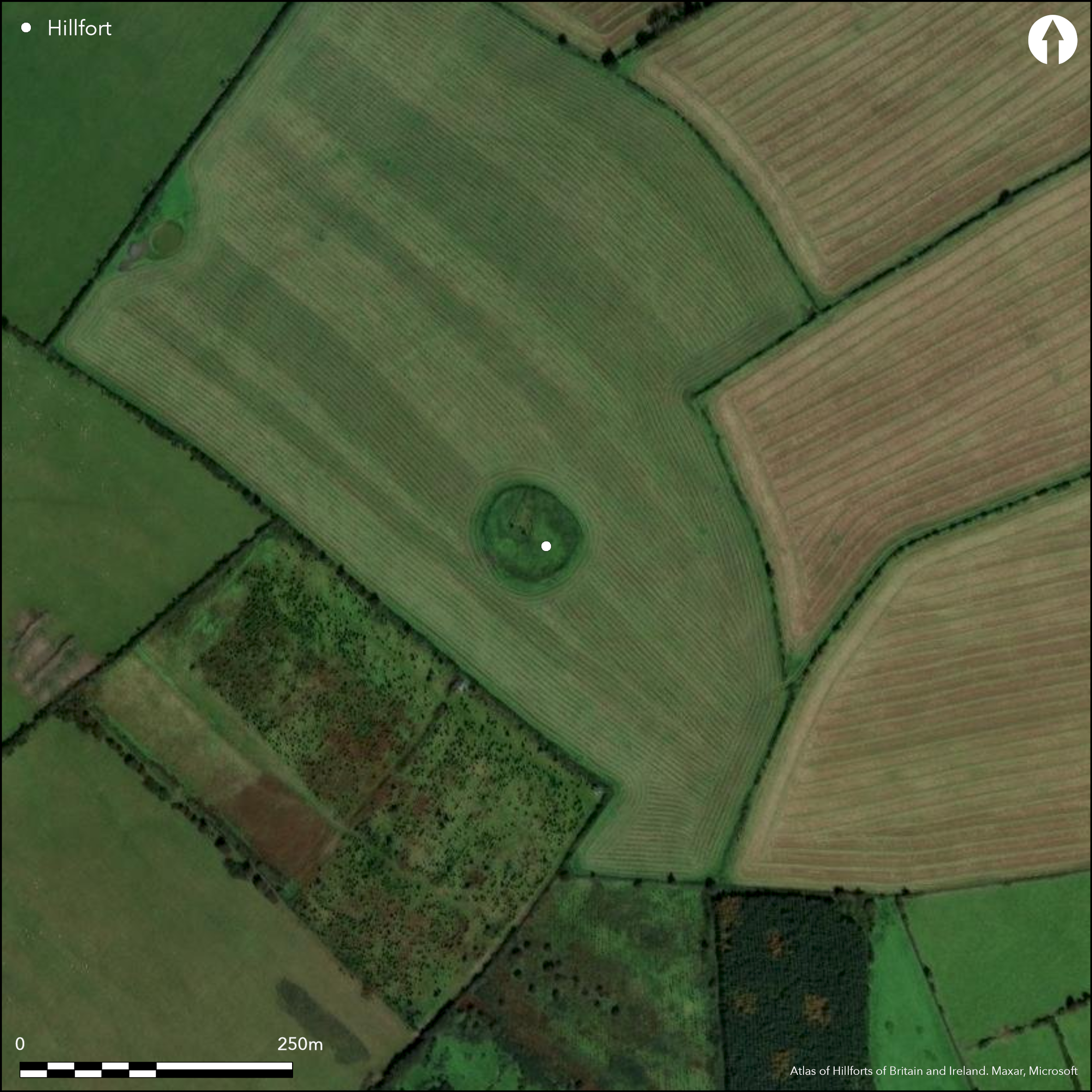
Cropmarks reveal a large, multiple enclosure surrounding the summit of Carrigeen Hill. Hughstwon hillfort is one of up to nine hillfort in a cluster surrounding the town of Baltinglass, Co. Wicklow. Roughly oval in plan, the hillfort has a total site footprint of 8.2ha. It is situated at the SW edge of the Wicklow Mountains in a commanding position, with panoramic views in all directions. Geophysical survey (O'Driscoll 2012) has revealed a complex system of enclosing elements. This includes an outer bank and ditch which surrounds a series of up to four closely set palisade features. The latter may have originally comprised two enclosures, each consisting of a bank (and possible palisade) with external ditch. The strong readings from the gradiometer survey imply that these features were destroyed by fire. Some possible hut structures were recorded by the geophysical survey. No entrance features were identified. At the summit of the hillfort is an extant enclosure. The bank of this enclosure comprises a circular band of large boulders approximately 55m in diameter. Near the centre of this enclosure, a circular bank of grass covered stones 18m in diameter may be the remains of a hut structure. Geophysical survey by O'Driscoll in 2012. LiDAR survey undertaken by Ordnance Survey Ireland. The Irish Army Air Corp and Cambridge aerial photographs reveal two enclosing elements as parch-marks, separated by 23 _ 48m.
Citizen Science: ✗
Reliability of Data: Confirmed
Reliability of Interpretation: Confirmed
X: -751407 Y: 6972747 (EPSG: 3857)
Longitude: -6.7500010559283155 Latitude: 52.94454770111065 (EPSG:4326)
Country: Republic of Ireland; None
Current County or Unitary Authority: Kildare
Historic County: Kildare
Current Parish/Community/Council/Townland: Hughstown
Small central enclosure extant. The majority of the hillfort has been levelled and is only visible as a vegetation mark.
| Extant | ✗ |
| Cropmark | ✗ |
| Likely Destroyed | ✓ |
The majority of the hillfort is located in pasture. Commercial forestry has been planted on the W section of the hillfort's enclosing elements.
| Woodland | ✗ |
| Commercial Forestry Plantation | ✓ |
| Parkland | ✗ |
| Pasture (Grazing) | ✓ |
| Arable | ✗ |
| Scrub/Bracken | ✗ |
| Bare Outcrop | ✗ |
| Heather/Moorland | ✗ |
| Heath | ✗ |
| Built-up | ✗ |
| Coastal Grassland | ✗ |
| Other | ✗ |
The hillfort surrounds the domed summit of Carrigeen Hill, with extensive views in all directions. It generally follows the contours of the hill, creating an oval shape in plan. Hughstown hillfort forms one of nine possible hillforts within the Baltinglass cluster.
| Contour Fort | ✓ |
| Partial Contour Fort | ✗ |
| Promontory Fort | ✗ |
| Hillslope Fort | ✗ |
| Level Terrain Fort | ✗ |
| Marsh Fort | ✗ |
| Multiple Enclosure Fort | ✓ |
| Hilltop | ✓ |
| Coastal Promontory | ✗ |
| Inland Promontory | ✗ |
| Valley Bottom | ✗ |
| Knoll/Hillock/Outcrop | ✗ |
| Ridge | ✗ |
| Cliff/Plateau-edge/Scarp | ✗ |
| Hillslope | ✗ |
| Lowland | ✗ |
| Spur | ✗ |
Dominant Topographic Feature: Hilltop
| North | ✗ |
| Northeast | ✗ |
| East | ✗ |
| Southeast | ✗ |
| South | ✗ |
| Southwest | ✗ |
| West | ✗ |
| Northwest | ✗ |
| Level | ✓ |
Altitude: 298.0m
The S section of the hillfort forms the townland boundary between Hughstown and Carrigeen.
Boundary Type: Parish/Townland
No dating evidence.
Reliability: D - None
| Pre 1200BC | ✗ |
| 1200BC - 800BC | ✗ |
| 800BC - 400BC | ✗ |
| 400BC - AD50 | ✗ |
| AD50 - AD400 | ✗ |
| AD400 - AD 800 | ✗ |
| Post AD800 | ✗ |
| Unknown | ✓ |
| Pre Hillfort: | Possible mound recorded within the interior, however, this is not visible on inspection. |
| Post Hillfort: | None |
Geophysical survey by O'Driscoll (2012). LiDAR survey undertaken by Ordnance Survey Ireland. The Irish Army Air Corp and Cambridge aerial photographs reveal two enclosing elements as parch-marks, separated by 23 _ 48m.
| Geophysical Survey (2012): | O'Driscoll in 2012. |
| 1st Identified Map Depiction (None): | Aerial photography by the Irish Army Air Corp and Cambridge aerial survey. |
| LiDAR Survey (None): | Ordnance Survey Ireland. |
Enclosure at summit of hillfort comprising a boulder bank with entrance in NE and possible structure within interior.
Pool positioned 80m to the NW. Embanked pond 360m from the hillfort on the E slopes of Carrigeen Hill.
| None | ✗ |
| Spring | ✗ |
| Stream | ✗ |
| Pool | ✓ |
| Flush | ✗ |
| Well | ✗ |
| Other | ✓ |
Inner extant enclosure
| No Known Features | ✗ |
| Round Stone Structures | ✗ |
| Rectangular Stone Structures | ✗ |
| Curvilinear Platforms | ✗ |
| Other Roundhouse Evidence | ✗ |
| Pits | ✗ |
| Quarry Hollows | ✗ |
| Other | ✓ |
None
| No Known Excavation | ✓ |
| Pits | ✗ |
| Postholes | ✗ |
| Roundhouses | ✗ |
| Rectangular Structures | ✗ |
| Roads/Tracks | ✗ |
| Quarry Hollows | ✗ |
| Other | ✗ |
| Nothing Found | ✗ |
Possible small pit features within interior. No obvious structures identified.
| No Known Geophysics | ✗ |
| Pits | ✓ |
| Roundhouses | ✗ |
| Rectangular Structures | ✗ |
| Roads/Tracks | ✗ |
| Quarry Hollows | ✗ |
| Other | ✗ |
| Nothing Found | ✗ |
Late bronze Age coarse-ware pottery.
| No Known Finds | ✗ |
| Pottery | ✓ |
| Metal | ✗ |
| Metalworking | ✗ |
| Human Bones | ✗ |
| Animal Bones | ✗ |
| Lithics | ✗ |
| Environmental | ✗ |
| Other | ✗ |
NO APPARENT FEATURES
| APs Not Checked | ✓ |
| None | ✗ |
| Roundhouses | ✗ |
| Rectangular Structures | ✗ |
| Pits | ✗ |
| Postholes | ✗ |
| Roads/Tracks | ✗ |
| Other | ✗ |
No obvious entrance features recorded.
| 0: | None |
| 2: | None |
Guard Chambers: ✗
Chevaux de Frise: ✗
Geophysical survey (O'Driscoll 2012) has identified up to 5 enclosing elements, all of which form complete circuits. The outer example comprises a bank and ditch feature. Approximately 40 meters inside the outer enclosing elements are a series of two closely set pairs of enclosures, 260 _ 300m in diameter. The respective positioning of these features suggests they were largely contemporary. They probably originally comprised two enclosures, each consisting of a bank (and possible palisade) with external ditch. The strong readings from the gradiometer survey imply that these features were destroyed by fire. The small enclosure at the centre of the hillfort comprises a large boulder bank with no corresponding ditch feature. This may be an Early Medieval ringfort. Condit (1998, 16) recorded a 2m wide entrance gap to the north which may be original. A large circular setting of stones 17m in diameter is visible near the centre of the enclosure.
| Area 1: | 3.58ha. |
| Area 2: | 4.55ha. |
| Total: | 4.55ha. |
Total Footprint Area: 8.22ha.
None
| ✗ | None |
| ✓ | None |
| NE Quadrant: | 5 |
| SE Quadrant: | 5 |
| SW Quadrant: | 5 |
| NW Quadrant: | 5 |
| Total: | 5 |
| Partial Univallate | ✗ |
| Univallate | ✗ |
| Partial Bivallate | ✗ |
| Bivallate | ✗ |
| Partial Multivallate | ✗ |
| Multivallate | ✓ |
| Unknown | ✗ |
| Partial Univallate | ✗ |
| Univallate | ✓ |
| Partial Bivallate | ✗ |
| Bivallate | ✗ |
| Partial Multivallate | ✗ |
| Multivallate | ✗ |
Geophysics indicate the hillfort comprises an outer bank and ditch feature which encloses a series of four closely-set palisaded enclosures.
| None | ✗ |
| Earthen Bank | ✗ |
| Stone Wall | ✗ |
| Rubble | ✗ |
| Wall-walk | ✗ |
| Evidence of Timber | ✗ |
| Vitrification | ✗ |
| Other Burning | ✗ |
| Palisade | ✓ |
| Counter Scarp Bank | ✗ |
| Berm | ✗ |
| Unfinished | ✗ |
| Other | ✓ |
None
| None | ✗ |
| Earthen Bank | ✗ |
| Stone Wall | ✗ |
| Murus Duplex | ✗ |
| Timber-framed | ✗ |
| Timber-laced | ✗ |
| Vitrification | ✗ |
| Other Burning | ✗ |
| Palisade | ✗ |
| Counter Scarp Bank | ✗ |
| Berm | ✗ |
| Unfinished | ✗ |
| No Known Excavation | ✓ |
| Other | ✗ |
| ✗ | None |
| ✓ | Geophysical survey has identified that the outer enclosing elements comprised a bank with external ditch. |
Number of Ditches: 1
| ✗ | None. |
Condit, C. 1992. Ireland's hillfort capital: Baltinglass, Co. Wicklow. Archaeology Ireland, Vol. 6 (3), 16-20.
Condit, C. 1998. Observations of the Baltinglass hillfort complex. In Corlett, C. and O'Sullivan, A. Wicklow Archaeology and History, Vol. 1, 9-25.
O'Driscoll, J. 2012. Unpublished Geophysical Survey Report: Hughstown Hillfort, Co. Kildare. UCC Cork, Dept of Archaeology.
Atlas of Hillforts:
Wikidata:
This work is licensed under CC BY-SA 4.0![]()
![]()
![]() and should be cited as:
and should be cited as:
Lock, Gary and Ralston, Ian. 2024. Atlas of Hillforts of Britain and Ireland. Available at: https://hillforts.arch.ox.ac.uk
Document Version 1.1