Satellite Imagery
Satellite Imagery
HER: Archaeological Survey of Ireland SMR Database KD020-001 (None)
NMR: KD 020 (None)
SM: None
NGR: None
X: 694990 Y: 722858 (IRENET95)
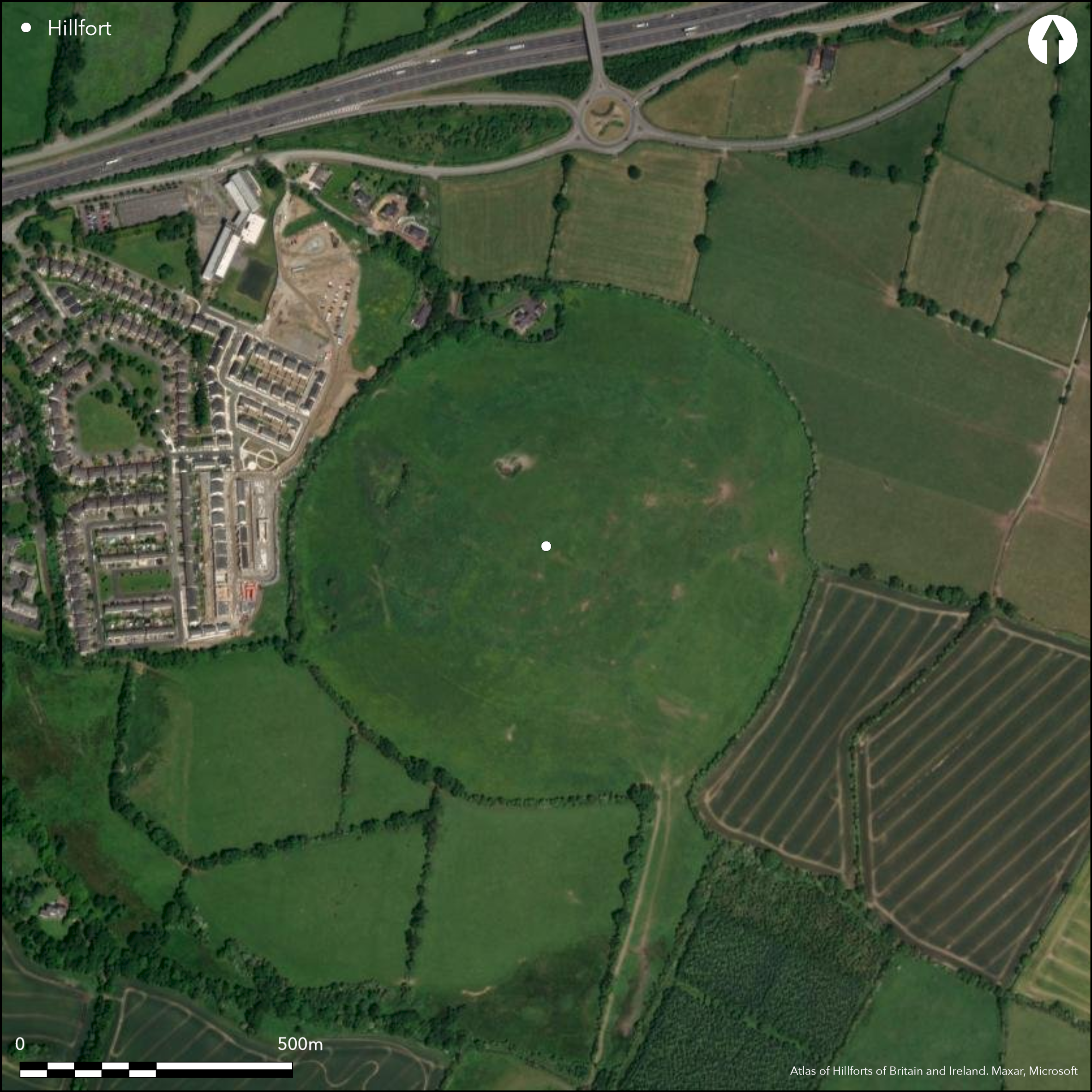
Multiple enclosure surrounding the low, domed summit and W slopes of Kill hill. The site is situated at the NE foothills of the Wicklow Mountains and overlooks the town of Naas to the SW. The site comprises three widely spaced (on average 120m apart) concentric enclosing elements which are circular in plan, measuring approximately 593 meters in maximum diameter. The site has a total footprint of 26.2ha. The outer enclosing elements comprise earthen banks topped with modern hedges and are likely to have been altered. The middle enclosing elements are apparent in the N, however, the remainder of its circuit and inner enclosing elements have been levelled and are visible only in aerial photography. There are no recorded entrance features. A possible ring-barrow is located between the inner and middle enclosing elements in the E. Interior is under pasture. There is some partial scrub growth at W of interior. LiDAR survey by Ordnance Survey Ireland. No archaeological investigations of hillfort. Depicted in first and second edition Ordnance Survey maps as a series of curving field boundaries.
Citizen Science: ✗
Reliability of Data: Confirmed
Reliability of Interpretation: Confirmed
X: -732113 Y: 7028926 (EPSG: 3857)
Longitude: -6.57668547334245 Latitude: 53.247581660237586 (EPSG:4326)
Country: Republic of Ireland; None
Current County or Unitary Authority: Kildare
Historic County: Kildare
Current Parish/Community/Council/Townland: Kill Hill
Outer enclosing element extant. N section of middle enclosing element extant. The remainder of the middle and inner enclosing elements are levelled and visible only as vegetation marks.
| Extant | ✓ |
| Cropmark | ✗ |
| Likely Destroyed | ✓ |
Partial scrub growth in W section of hillfort.
| Woodland | ✗ |
| Commercial Forestry Plantation | ✗ |
| Parkland | ✗ |
| Pasture (Grazing) | ✓ |
| Arable | ✗ |
| Scrub/Bracken | ✓ |
| Bare Outcrop | ✗ |
| Heather/Moorland | ✗ |
| Heath | ✗ |
| Built-up | ✗ |
| Coastal Grassland | ✗ |
| Other | ✗ |
Large, multivallate hillfort surrounding the domed summit and W slopes of Kill Hill. The site is situated at the NE foothills of the Wicklow Mountains and overlooks the town of Naas to the SW, with panoramic views in all directions.
| Contour Fort | ✓ |
| Partial Contour Fort | ✗ |
| Promontory Fort | ✗ |
| Hillslope Fort | ✗ |
| Level Terrain Fort | ✗ |
| Marsh Fort | ✗ |
| Multiple Enclosure Fort | ✓ |
| Hilltop | ✓ |
| Coastal Promontory | ✗ |
| Inland Promontory | ✗ |
| Valley Bottom | ✗ |
| Knoll/Hillock/Outcrop | ✗ |
| Ridge | ✗ |
| Cliff/Plateau-edge/Scarp | ✗ |
| Hillslope | ✗ |
| Lowland | ✗ |
| Spur | ✗ |
Dominant Topographic Feature: Hilltop.
| North | ✗ |
| Northeast | ✗ |
| East | ✗ |
| Southeast | ✗ |
| South | ✗ |
| Southwest | ✗ |
| West | ✓ |
| Northwest | ✗ |
| Level | ✗ |
Altitude: 153.0m
The NE section of the hillfort forms the townland boundary between Kill Hill and Boherphilip. The SE section of the hillfort forms the townland boundary between Kill Hill and Rathgorragh.
Boundary Type: Parish/Townland
No dating evidence.
Reliability: D - None
| Pre 1200BC | ✗ |
| 1200BC - 800BC | ✗ |
| 800BC - 400BC | ✗ |
| 400BC - AD50 | ✗ |
| AD50 - AD400 | ✗ |
| AD400 - AD 800 | ✗ |
| Post AD800 | ✗ |
| Unknown | ✓ |
| Pre Hillfort: | Possible large ring-barrow in-between middle and outer enclosing elements to E. This monument may also be contemporary or later than the hillfort. |
| Post Hillfort: | None |
LiDAR survey by Ordnance Survey Ireland. No archaeological investigations of hillfort. Depicted in first and second edition Ordnance Survey maps as a series of curving field boundaries.
| LiDAR Survey (None): | Ordnance Survey ireland |
Possible large ring-barrow in-between middle and outer enclosing elements to E. Post-Medieval quarry hollows to the W.
None
| None | ✓ |
| Spring | ✗ |
| Stream | ✗ |
| Pool | ✗ |
| Flush | ✗ |
| Well | ✗ |
| Other | ✗ |
Possible ring-barrow, Post-Medieval quarry hollows
| No Known Features | ✗ |
| Round Stone Structures | ✗ |
| Rectangular Stone Structures | ✗ |
| Curvilinear Platforms | ✗ |
| Other Roundhouse Evidence | ✗ |
| Pits | ✗ |
| Quarry Hollows | ✓ |
| Other | ✓ |
None
| No Known Excavation | ✓ |
| Pits | ✗ |
| Postholes | ✗ |
| Roundhouses | ✗ |
| Rectangular Structures | ✗ |
| Roads/Tracks | ✗ |
| Quarry Hollows | ✗ |
| Other | ✗ |
| Nothing Found | ✗ |
None
| No Known Geophysics | ✓ |
| Pits | ✗ |
| Roundhouses | ✗ |
| Rectangular Structures | ✗ |
| Roads/Tracks | ✗ |
| Quarry Hollows | ✗ |
| Other | ✗ |
| Nothing Found | ✗ |
None
| No Known Finds | ✓ |
| Pottery | ✗ |
| Metal | ✗ |
| Metalworking | ✗ |
| Human Bones | ✗ |
| Animal Bones | ✗ |
| Lithics | ✗ |
| Environmental | ✗ |
| Other | ✗ |
NO APPARENT FEATURES
| APs Not Checked | ✗ |
| None | ✓ |
| Roundhouses | ✗ |
| Rectangular Structures | ✗ |
| Pits | ✗ |
| Postholes | ✗ |
| Roads/Tracks | ✗ |
| Other | ✗ |
No obvious entrance features recorded.
| 0: | None |
| 2: | None |
Guard Chambers: ✗
Chevaux de Frise: ✗
Three widely spaced earthen banks with no apparent ditch features. These enclosing elements are concentric and circular in plan.
| Area 1: | 1.44ha. |
| Area 2: | 10.11ha. |
| Area 3: | 26.26ha. |
| Total: | 26.26ha. |
Total Footprint Area: 26.26ha.
None
| ✗ | None |
| ✓ | Aerial photography shows that all three of the enclosing features form complete citcuits. |
| NE Quadrant: | 3 |
| SE Quadrant: | 3 |
| SW Quadrant: | 3 |
| NW Quadrant: | 3 |
| Total: | 3 |
| Partial Univallate | ✗ |
| Univallate | ✗ |
| Partial Bivallate | ✗ |
| Bivallate | ✗ |
| Partial Multivallate | ✗ |
| Multivallate | ✓ |
| Unknown | ✗ |
| Partial Univallate | ✗ |
| Univallate | ✓ |
| Partial Bivallate | ✗ |
| Bivallate | ✗ |
| Partial Multivallate | ✗ |
| Multivallate | ✗ |
None
| None | ✗ |
| Earthen Bank | ✓ |
| Stone Wall | ✗ |
| Rubble | ✗ |
| Wall-walk | ✗ |
| Evidence of Timber | ✗ |
| Vitrification | ✗ |
| Other Burning | ✗ |
| Palisade | ✗ |
| Counter Scarp Bank | ✗ |
| Berm | ✗ |
| Unfinished | ✗ |
| Other | ✗ |
None
| None | ✗ |
| Earthen Bank | ✗ |
| Stone Wall | ✗ |
| Murus Duplex | ✗ |
| Timber-framed | ✗ |
| Timber-laced | ✗ |
| Vitrification | ✗ |
| Other Burning | ✗ |
| Palisade | ✗ |
| Counter Scarp Bank | ✗ |
| Berm | ✗ |
| Unfinished | ✗ |
| No Known Excavation | ✓ |
| Other | ✗ |
| ✗ | None |
| ✗ | No apparent ditch features. |
Number of Ditches: 0
| ✗ | None. |
No related records
Atlas of Hillforts:
Wikidata:
This work is licensed under CC BY-SA 4.0![]()
![]()
![]() and should be cited as:
and should be cited as:
Lock, Gary and Ralston, Ian. 2024. Atlas of Hillforts of Britain and Ireland. Available at: https://hillforts.arch.ox.ac.uk
Document Version 1.1