Satellite Imagery
Satellite Imagery
HER: Archaeological Survey of Ireland SMR Database LI013-094 (None)
NMR: LI 013 (None)
SM: None
NGR: None
X: 558416 Y: 649322 (IRENET95)
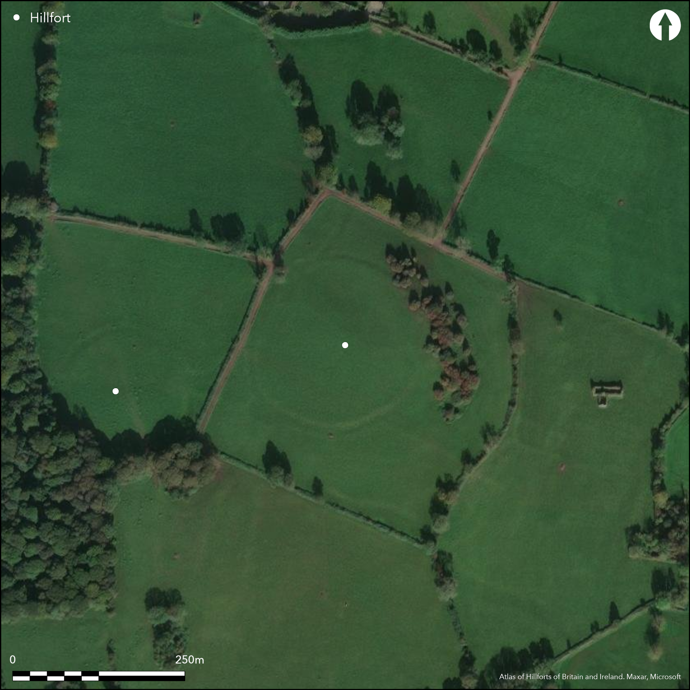
Contour fort situated on the low-domed hill shoulder of an isolated hill, 7.5km S of Limerick City. The hillfort has a total site footprint of 2.1ha. There are extensive views to the N, E and S. Views to the W are blocked by the summit of Friarstown Hill. Immediately to the SW is a second hillfort on the low-domed summit of Friarstown Hill (Atlas No.0682). The enclosing elements comprise a pair of closely set banks with an intervening ditch. The outer bank is probably a counterscarp feature. There are no recorded entrance features. No evidence for any internal features on the surface. Extensive plough damage had denuded the enclosing elements, which survive best to the SE and SW. Kelly and Condit (1998, 19) has suggested that this is a large henge monument. However, the commanding position of the monument and the layout of its enclosing elements suggest that it is more likely a hillfort type monument. First identified by the Cambridge University Committee for aerial photography. Site visit by Kelly and Condit (1998) who partly recorded the enclosing elements.
Citizen Science: ✗
Reliability of Data: Confirmed
Reliability of Interpretation: Confirmed
X: -958879 Y: 6908172 (EPSG: 3857)
Longitude: -8.613754999838173 Latitude: 52.593578313890156 (EPSG:4326)
Country: Republic of Ireland
Current County or Unitary Authority: Limerick
Historic County: Limerick
Current Parish/Community/Council/Townland: Friarstown
Heavily truncated by plough damage.
| Extant | ✓ |
| Cropmark | ✗ |
| Likely Destroyed | ✗ |
None
| Woodland | ✗ |
| Commercial Forestry Plantation | ✗ |
| Parkland | ✗ |
| Pasture (Grazing) | ✓ |
| Arable | ✗ |
| Scrub/Bracken | ✗ |
| Bare Outcrop | ✗ |
| Heather/Moorland | ✗ |
| Heath | ✗ |
| Built-up | ✗ |
| Coastal Grassland | ✗ |
| Other | ✗ |
Contour fort positioned on the low-domed hill shoulder of an isolated hill, 7.5km S of Limerick City. There are extensive views to the N, E and S. Views to the W are blocked by the summit of Friarstown Hill.
| Contour Fort | ✓ |
| Partial Contour Fort | ✗ |
| Promontory Fort | ✗ |
| Hillslope Fort | ✗ |
| Level Terrain Fort | ✗ |
| Marsh Fort | ✗ |
| Multiple Enclosure Fort | ✗ |
| Hilltop | ✓ |
| Coastal Promontory | ✗ |
| Inland Promontory | ✗ |
| Valley Bottom | ✗ |
| Knoll/Hillock/Outcrop | ✗ |
| Ridge | ✗ |
| Cliff/Plateau-edge/Scarp | ✗ |
| Hillslope | ✗ |
| Lowland | ✗ |
| Spur | ✗ |
Dominant Topographic Feature: Hill shoulder.
| North | ✗ |
| Northeast | ✗ |
| East | ✗ |
| Southeast | ✗ |
| South | ✗ |
| Southwest | ✗ |
| West | ✗ |
| Northwest | ✗ |
| Level | ✓ |
Altitude: 76.0m
N/A
No dating evidence.
Reliability: D - None
| Pre 1200BC | ✗ |
| 1200BC - 800BC | ✗ |
| 800BC - 400BC | ✗ |
| 400BC - AD50 | ✗ |
| AD50 - AD400 | ✗ |
| AD400 - AD 800 | ✗ |
| Post AD800 | ✗ |
| Unknown | ✓ |
| Pre Hillfort: | None |
| Post Hillfort: | Post-Medieval limekiln near NE of enclosing elements. |
First identified by the Cambridge University Committee for aerial photography. Site visit by Kelly and Condit (1998) who partly recorded the enclosing elements.
| Other (1998): | Kelly and Condit (1998). |
| Other (1998): | Visited by Hillfort Study Group |
| 1st Identified Map Depiction (None): | CUCAP |
No evidence for any internal features on the surface.
None
| None | ✓ |
| Spring | ✗ |
| Stream | ✗ |
| Pool | ✗ |
| Flush | ✗ |
| Well | ✗ |
| Other | ✗ |
None
| No Known Features | ✓ |
| Round Stone Structures | ✗ |
| Rectangular Stone Structures | ✗ |
| Curvilinear Platforms | ✗ |
| Other Roundhouse Evidence | ✗ |
| Pits | ✗ |
| Quarry Hollows | ✗ |
| Other | ✗ |
None
| No Known Excavation | ✓ |
| Pits | ✗ |
| Postholes | ✗ |
| Roundhouses | ✗ |
| Rectangular Structures | ✗ |
| Roads/Tracks | ✗ |
| Quarry Hollows | ✗ |
| Other | ✗ |
| Nothing Found | ✗ |
None
| No Known Geophysics | ✓ |
| Pits | ✗ |
| Roundhouses | ✗ |
| Rectangular Structures | ✗ |
| Roads/Tracks | ✗ |
| Quarry Hollows | ✗ |
| Other | ✗ |
| Nothing Found | ✗ |
None
| No Known Finds | ✓ |
| Pottery | ✗ |
| Metal | ✗ |
| Metalworking | ✗ |
| Human Bones | ✗ |
| Animal Bones | ✗ |
| Lithics | ✗ |
| Environmental | ✗ |
| Other | ✗ |
NO APPARENT FEATURES
| APs Not Checked | ✗ |
| None | ✓ |
| Roundhouses | ✗ |
| Rectangular Structures | ✗ |
| Pits | ✗ |
| Postholes | ✗ |
| Roads/Tracks | ✗ |
| Other | ✗ |
No obvious entrance features recorded. The enclosing elements have been heavily truncated by ploughing.
| 0: | None |
| 2: | None |
Guard Chambers: ✗
Chevaux de Frise: ✗
The enclosing elements consist of an internal and external bank with an intervening ditch. It survives best at the SE and SW. Here, the inner bank is 6m wide and is 1.7m above the bottom of the ditch. The ditch measures 2.5m wide. The outer bank is 3m wide and is 0.5m above the bottom of the ditch (Kelly and Condit 1998, 19). This may suggest it is a counterscarp.
| Area 1: | 1.81ha. |
| Total: | 1.81ha. |
Total Footprint Area: 2.11ha.
None
| ✗ | None |
| ✓ | Outer bank may be a counter scarp. |
| NE Quadrant: | 1 |
| SE Quadrant: | 1 |
| SW Quadrant: | 1 |
| NW Quadrant: | 1 |
| Total: | 1 |
| Partial Univallate | ✗ |
| Univallate | ✓ |
| Partial Bivallate | ✗ |
| Bivallate | ✗ |
| Partial Multivallate | ✗ |
| Multivallate | ✗ |
| Unknown | ✗ |
| Partial Univallate | ✗ |
| Univallate | ✗ |
| Partial Bivallate | ✗ |
| Bivallate | ✗ |
| Partial Multivallate | ✗ |
| Multivallate | ✗ |
None
| None | ✗ |
| Earthen Bank | ✓ |
| Stone Wall | ✗ |
| Rubble | ✗ |
| Wall-walk | ✗ |
| Evidence of Timber | ✗ |
| Vitrification | ✗ |
| Other Burning | ✗ |
| Palisade | ✗ |
| Counter Scarp Bank | ✓ |
| Berm | ✗ |
| Unfinished | ✗ |
| Other | ✗ |
None
| None | ✓ |
| Earthen Bank | ✗ |
| Stone Wall | ✗ |
| Murus Duplex | ✗ |
| Timber-framed | ✗ |
| Timber-laced | ✗ |
| Vitrification | ✗ |
| Other Burning | ✗ |
| Palisade | ✗ |
| Counter Scarp Bank | ✗ |
| Berm | ✗ |
| Unfinished | ✗ |
| No Known Excavation | ✗ |
| Other | ✗ |
| ✗ | None |
| ✓ | None |
Number of Ditches: 1
| ✗ | None. |
Kelly, E. and Condit, T. 1998. Limerick's Tara. Archaeology Ireland (2). 18-22.
Atlas of Hillforts:
Wikidata:
This work is licensed under CC BY-SA 4.0![]()
![]()
![]() and should be cited as:
and should be cited as:
Lock, Gary and Ralston, Ian. 2024. Atlas of Hillforts of Britain and Ireland. Available at: https://hillforts.arch.ox.ac.uk
Document Version 1.1