Satellite Imagery
Satellite Imagery
HER: Archaeological Survey of Ireland SMR Database TN014-033002 (None)
NMR: TN 014 (None)
SM: None
NGR: None
X: 585772 Y: 685357 (IRENET95)
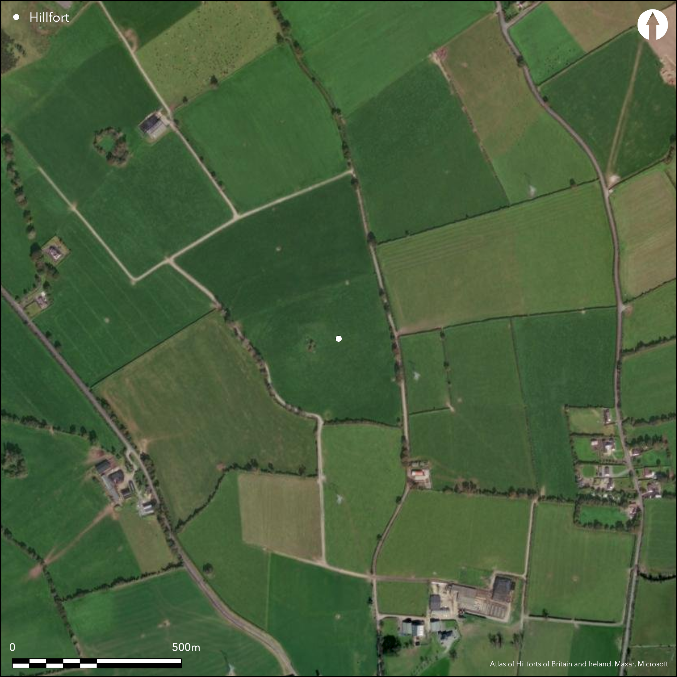
Multiple enclosure following natural contours, surrounding S summit of isolated steep dome-shaped hill surrounded by low-lying terrain. Hillfort overlooks Lough Eorna to E and Dromineer Bay is visible to W. Geophysical survey (O'Driscoll 2012) has identified that Knigh hillfort is probably bivallate. It has a total site foot print of 5.4ha. There are no recorded entrance features in either enclosing element. A cairn and conjoined mound are positioned at the centre of the hillfort. Geophysical survey has identified a number of small pit features distributed throughout the interior and two possible structures. The enclosing elements are levelled are and are only visible in aerial photography. The site was first identified by Manning (1983) and O'Driscoll surveyed the monument in 2012.
Citizen Science: ✗
Reliability of Data: Confirmed
Reliability of Interpretation: Confirmed
X: -914107 Y: 6968003 (EPSG: 3857)
Longitude: -8.21156600597058 Latitude: 52.91885633512018 (EPSG:4326)
Country: Republic of Ireland
Current County or Unitary Authority: Tipperary
Historic County: Tipperary
Current Parish/Community/Council/Townland: Knigh
Visible in aerial photography. Confirmed by geophysics (O'Driscoll 2012)
| Extant | ✗ |
| Cropmark | ✗ |
| Likely Destroyed | ✓ |
None
| Woodland | ✗ |
| Commercial Forestry Plantation | ✗ |
| Parkland | ✗ |
| Pasture (Grazing) | ✓ |
| Arable | ✗ |
| Scrub/Bracken | ✗ |
| Bare Outcrop | ✗ |
| Heather/Moorland | ✗ |
| Heath | ✗ |
| Built-up | ✗ |
| Coastal Grassland | ✗ |
| Other | ✗ |
Multiple enclosure following natural contours, surrounding S summit of isolated steep dome-shaped hill surrounded by low-lying terrain. Panoramic views from the summit.
| Contour Fort | ✓ |
| Partial Contour Fort | ✗ |
| Promontory Fort | ✗ |
| Hillslope Fort | ✗ |
| Level Terrain Fort | ✗ |
| Marsh Fort | ✗ |
| Multiple Enclosure Fort | ✓ |
| Hilltop | ✓ |
| Coastal Promontory | ✗ |
| Inland Promontory | ✗ |
| Valley Bottom | ✗ |
| Knoll/Hillock/Outcrop | ✗ |
| Ridge | ✗ |
| Cliff/Plateau-edge/Scarp | ✗ |
| Hillslope | ✗ |
| Lowland | ✗ |
| Spur | ✗ |
Dominant Topographic Feature: Isolated steep dome-shaped hill with surrounding low-lying terrain.
| North | ✗ |
| Northeast | ✗ |
| East | ✗ |
| Southeast | ✗ |
| South | ✗ |
| Southwest | ✗ |
| West | ✗ |
| Northwest | ✗ |
| Level | ✓ |
Altitude: 125.0m
N/A
No dating evidence.
Reliability: D - None
| Pre 1200BC | ✗ |
| 1200BC - 800BC | ✗ |
| 800BC - 400BC | ✗ |
| 400BC - AD50 | ✗ |
| AD50 - AD400 | ✗ |
| AD400 - AD 800 | ✗ |
| Post AD800 | ✗ |
| Unknown | ✓ |
| Pre Hillfort: | Cairn and conjoined mount. |
| Post Hillfort: | None |
First identified by Manning in 1983. Geophysical survey of hillfort by O'Driscoll in 2012.
| 1st Identified Written Reference (1983): | Manning (1985, 48) |
| Geophysical Survey (2012): | O'Driscoll |
Circular cairn positioned at highest point within interior measuring 20m diameter and 2.5m in maximum height. A low circular mound 20m in diameter abuts the cairn to the S. Two possible structures identified within the interior by geophysics (O'Driscoll 2012) and a number of small pit features dispersed through the hillfort interior.
None
| None | ✓ |
| Spring | ✗ |
| Stream | ✗ |
| Pool | ✗ |
| Flush | ✗ |
| Well | ✗ |
| Other | ✗ |
None
| No Known Features | ✓ |
| Round Stone Structures | ✗ |
| Rectangular Stone Structures | ✗ |
| Curvilinear Platforms | ✗ |
| Other Roundhouse Evidence | ✗ |
| Pits | ✗ |
| Quarry Hollows | ✗ |
| Other | ✗ |
None
| No Known Excavation | ✓ |
| Pits | ✗ |
| Postholes | ✗ |
| Roundhouses | ✗ |
| Rectangular Structures | ✗ |
| Roads/Tracks | ✗ |
| Quarry Hollows | ✗ |
| Other | ✗ |
| Nothing Found | ✗ |
None
| No Known Geophysics | ✗ |
| Pits | ✓ |
| Roundhouses | ✓ |
| Rectangular Structures | ✗ |
| Roads/Tracks | ✗ |
| Quarry Hollows | ✗ |
| Other | ✗ |
| Nothing Found | ✗ |
None
| No Known Finds | ✓ |
| Pottery | ✗ |
| Metal | ✗ |
| Metalworking | ✗ |
| Human Bones | ✗ |
| Animal Bones | ✗ |
| Lithics | ✗ |
| Environmental | ✗ |
| Other | ✗ |
NO APPARENT FEATURES
| APs Not Checked | ✗ |
| None | ✓ |
| Roundhouses | ✗ |
| Rectangular Structures | ✗ |
| Pits | ✗ |
| Postholes | ✗ |
| Roads/Tracks | ✗ |
| Other | ✗ |
No obvious entrance features recorded.
| 0: | None |
| 2: | None |
Guard Chambers: ✗
Chevaux de Frise: ✗
Enclosing elements levelled and visible on aerial photography. Formerly best preserved at the N and defined by field boundary on S and W (Manning 1985, 48). It comprises a bank and external ditch. This was confirmed by geophysical survey (O'Driscoll 2012). Both first and second edition Ordnance Survey mapping suggest that the inner defences were partially incorporated into a field system at its SW, which is still present today. A possible second enclosing element was identified at the N, approximately 54m from the inner enclosing element (O'Driscoll 2012).
| Area 1: | 2.99ha. |
| Area 2: | 5.4ha. |
| Total: | 5.4ha. |
Total Footprint Area: 5.4ha.
None
| ✗ | None |
| ✓ | Modern track overlying possible outer enclosing elements at SE and NE. |
| NE Quadrant: | 1 |
| SE Quadrant: | 1 |
| SW Quadrant: | 2 |
| NW Quadrant: | 2 |
| Total: | 2 |
| Partial Univallate | ✓ |
| Univallate | ✗ |
| Partial Bivallate | ✓ |
| Bivallate | ✗ |
| Partial Multivallate | ✗ |
| Multivallate | ✗ |
| Unknown | ✗ |
| Partial Univallate | ✗ |
| Univallate | ✓ |
| Partial Bivallate | ✗ |
| Bivallate | ✗ |
| Partial Multivallate | ✗ |
| Multivallate | ✗ |
None
| None | ✓ |
| Earthen Bank | ✗ |
| Stone Wall | ✗ |
| Rubble | ✗ |
| Wall-walk | ✗ |
| Evidence of Timber | ✗ |
| Vitrification | ✗ |
| Other Burning | ✗ |
| Palisade | ✗ |
| Counter Scarp Bank | ✗ |
| Berm | ✗ |
| Unfinished | ✗ |
| Other | ✗ |
None
| None | ✗ |
| Earthen Bank | ✗ |
| Stone Wall | ✗ |
| Murus Duplex | ✗ |
| Timber-framed | ✗ |
| Timber-laced | ✗ |
| Vitrification | ✗ |
| Other Burning | ✗ |
| Palisade | ✗ |
| Counter Scarp Bank | ✗ |
| Berm | ✗ |
| Unfinished | ✗ |
| No Known Excavation | ✓ |
| Other | ✗ |
| ✗ | None |
| ✓ | External ditch. |
Number of Ditches: 1
| ✗ | None. |
Farrelly, J. and O'Brien, C. 2002. Archaeological Inventory of County Tipperary. Volume 1: North Tipperary. Department of the Arts, Heritage and the Gaeltacht.
Manning, C. 1983. Prehistoric sites in the neighborhood of Ardcroney. Eile 2, 43 - 45.
O'Driscoll, J. 2012 Unpublished geophysical survey report: Knigh, Co. Tipperary. UCC Cork, Dept of Archaeology.
Atlas of Hillforts:
Wikidata:
This work is licensed under CC BY-SA 4.0![]()
![]()
![]() and should be cited as:
and should be cited as:
Lock, Gary and Ralston, Ian. 2024. Atlas of Hillforts of Britain and Ireland. Available at: https://hillforts.arch.ox.ac.uk
Document Version 1.1