Satellite Imagery
Satellite Imagery
HER: Archaeological Survey of Ireland SMR Database WX025-034 (None)
NMR: WX 025 (None)
SM: None
NGR: None
X: 694990 Y: 633424 (IRENET95)
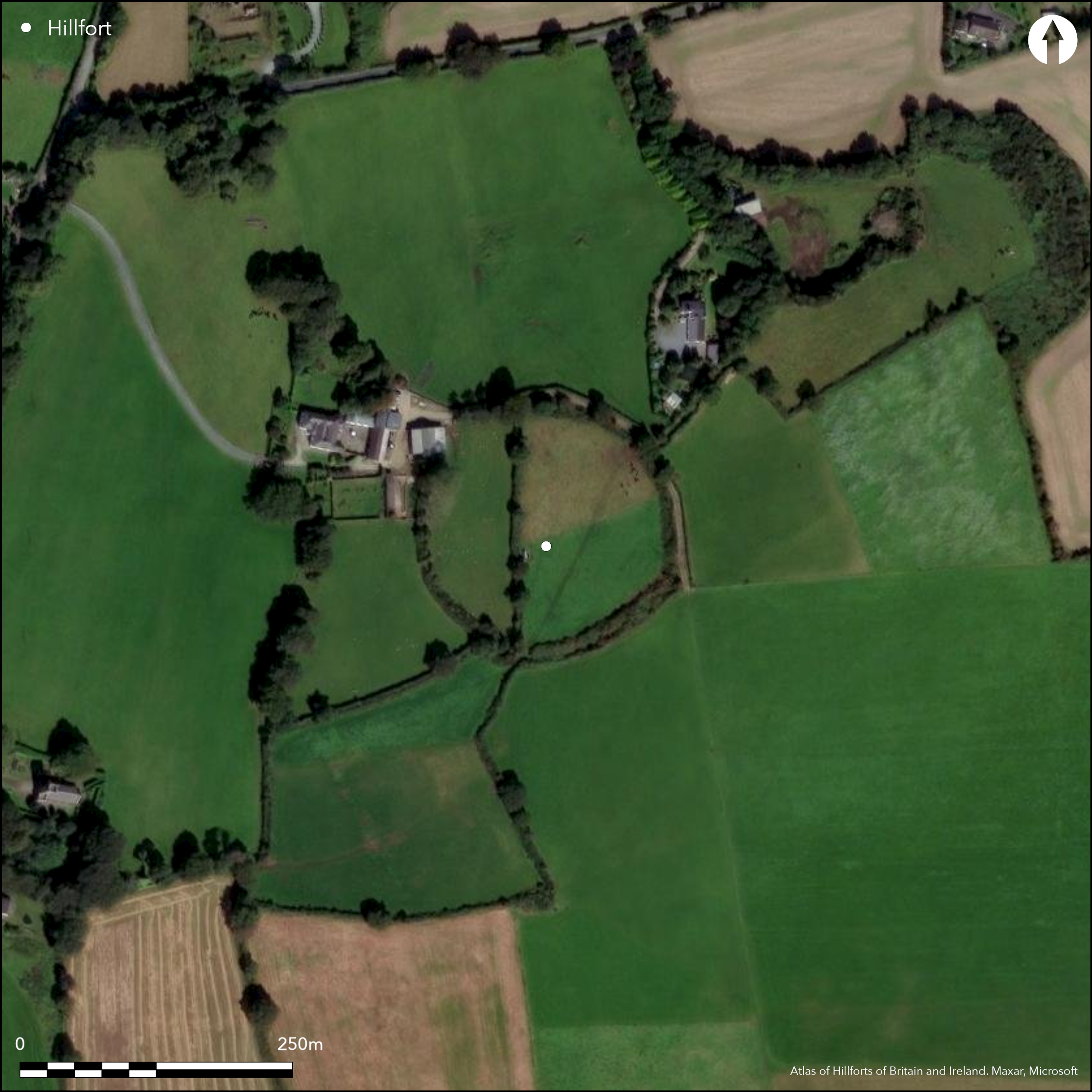
Circular contour fort surrounding summit of Ballybuckley Hill with panoramic views from summit. Excellent views of the Slaney River to NE, E and SE. Enclosing elements form a complete circuit and have a total site footprint of about 1.8ha. Three breaks in the enclosing elements are likely to be modern gaps. No evidence for any internal features on the surface. The ramparts survive well throughout. Partial destruction of the N section of the enclosing elements, replaced by modern field bank. The interior is under pasture and is divided by a later field boundary. Earliest identified map depiction in first edition Ordnance Survey 6 inch mapping. More detailed earthwork survey in second edition Ordnance Survey maps. Monument survey by Moore (1996, 25).
Citizen Science: ✗
Reliability of Data: Confirmed
Reliability of Interpretation: Confirmed
X: -735012 Y: 6880812 (EPSG: 3857)
Longitude: -6.602728423048189 Latitude: 52.44402051113277 (EPSG:4326)
Country: Republic of Ireland
Current County or Unitary Authority: Wexford
Historic County: Wexford
Current Parish/Community/Council/Townland: Ballybuckley
None
| Extant | ✓ |
| Cropmark | ✗ |
| Likely Destroyed | ✗ |
Tree cover over the enclosing elements. The interior is under pasture.
| Woodland | ✓ |
| Commercial Forestry Plantation | ✗ |
| Parkland | ✗ |
| Pasture (Grazing) | ✓ |
| Arable | ✗ |
| Scrub/Bracken | ✗ |
| Bare Outcrop | ✗ |
| Heather/Moorland | ✗ |
| Heath | ✗ |
| Built-up | ✗ |
| Coastal Grassland | ✗ |
| Other | ✗ |
Circular contour fort surrounding summit of Ballybuckley Hill. Panoramic views from summit. Overlooked by Bree Hill 1.4km to W and Carrig Hill 0.9km to NW but with excellent views of the Slaney River to the NE, E and SE.
| Contour Fort | ✓ |
| Partial Contour Fort | ✗ |
| Promontory Fort | ✗ |
| Hillslope Fort | ✗ |
| Level Terrain Fort | ✗ |
| Marsh Fort | ✗ |
| Multiple Enclosure Fort | ✗ |
| Hilltop | ✓ |
| Coastal Promontory | ✗ |
| Inland Promontory | ✗ |
| Valley Bottom | ✗ |
| Knoll/Hillock/Outcrop | ✗ |
| Ridge | ✗ |
| Cliff/Plateau-edge/Scarp | ✗ |
| Hillslope | ✗ |
| Lowland | ✗ |
| Spur | ✗ |
Dominant Topographic Feature: Hilltop.
| North | ✗ |
| Northeast | ✗ |
| East | ✗ |
| Southeast | ✗ |
| South | ✗ |
| Southwest | ✗ |
| West | ✗ |
| Northwest | ✗ |
| Level | ✓ |
Altitude: 92.0m
N/A
No dating evidence.
Reliability: D - None
| Pre 1200BC | ✗ |
| 1200BC - 800BC | ✗ |
| 800BC - 400BC | ✗ |
| 400BC - AD50 | ✗ |
| AD50 - AD400 | ✗ |
| AD400 - AD 800 | ✗ |
| Post AD800 | ✗ |
| Unknown | ✓ |
| Pre Hillfort: | None |
| Post Hillfort: | None |
Earliest identified map detection in first edition Ordnance Survey 6 inch mapping. More detailed earthwork survey in second edition Ordnance Survey maps. Monument survey by Moore (1996, 25).
| 1st Identified Map Depiction (1842): | First edition Ordnance Survey 6 inch mapping. |
| Earthwork Survey (1906): | Second edition 25 inch Ordnance Survey mapping. |
| Other (1996): | Monument survey by Moore (1996). |
No evidence for any internal features on the surface.
None
| None | ✓ |
| Spring | ✗ |
| Stream | ✗ |
| Pool | ✗ |
| Flush | ✗ |
| Well | ✗ |
| Other | ✗ |
None
| No Known Features | ✓ |
| Round Stone Structures | ✗ |
| Rectangular Stone Structures | ✗ |
| Curvilinear Platforms | ✗ |
| Other Roundhouse Evidence | ✗ |
| Pits | ✗ |
| Quarry Hollows | ✗ |
| Other | ✗ |
None
| No Known Excavation | ✓ |
| Pits | ✗ |
| Postholes | ✗ |
| Roundhouses | ✗ |
| Rectangular Structures | ✗ |
| Roads/Tracks | ✗ |
| Quarry Hollows | ✗ |
| Other | ✗ |
| Nothing Found | ✗ |
None
| No Known Geophysics | ✓ |
| Pits | ✗ |
| Roundhouses | ✗ |
| Rectangular Structures | ✗ |
| Roads/Tracks | ✗ |
| Quarry Hollows | ✗ |
| Other | ✗ |
| Nothing Found | ✗ |
None
| No Known Finds | ✓ |
| Pottery | ✗ |
| Metal | ✗ |
| Metalworking | ✗ |
| Human Bones | ✗ |
| Animal Bones | ✗ |
| Lithics | ✗ |
| Environmental | ✗ |
| Other | ✗ |
NO APPARENT FEATURES
| APs Not Checked | ✗ |
| None | ✓ |
| Roundhouses | ✗ |
| Rectangular Structures | ✗ |
| Pits | ✗ |
| Postholes | ✗ |
| Roads/Tracks | ✗ |
| Other | ✗ |
Three likely modern entrances at NE, S and NW.
| 3: | None |
| 2: | None |
Guard Chambers: ✗
Chevaux de Frise: ✗
Earthen bank approximately 11m in maximum width and 1m in maximum height. No evidence for a ditch feature. The bank is replaced by field bank at N. Possible outer bank at NE - SSW.
| Area 1: | 1.48ha. |
| Total: | 1.48ha. |
Total Footprint Area: 1.77ha.
None
| ✗ | None |
| ✓ | None |
| NE Quadrant: | 1 |
| SE Quadrant: | 1 |
| SW Quadrant: | 1 |
| NW Quadrant: | 1 |
| Total: | 1 |
| Partial Univallate | ✗ |
| Univallate | ✓ |
| Partial Bivallate | ✗ |
| Bivallate | ✗ |
| Partial Multivallate | ✗ |
| Multivallate | ✗ |
| Unknown | ✗ |
| Partial Univallate | ✗ |
| Univallate | ✗ |
| Partial Bivallate | ✗ |
| Bivallate | ✗ |
| Partial Multivallate | ✗ |
| Multivallate | ✗ |
None
| None | ✗ |
| Earthen Bank | ✓ |
| Stone Wall | ✗ |
| Rubble | ✗ |
| Wall-walk | ✗ |
| Evidence of Timber | ✗ |
| Vitrification | ✗ |
| Other Burning | ✗ |
| Palisade | ✗ |
| Counter Scarp Bank | ✗ |
| Berm | ✗ |
| Unfinished | ✗ |
| Other | ✗ |
None
| None | ✗ |
| Earthen Bank | ✗ |
| Stone Wall | ✗ |
| Murus Duplex | ✗ |
| Timber-framed | ✗ |
| Timber-laced | ✗ |
| Vitrification | ✗ |
| Other Burning | ✗ |
| Palisade | ✗ |
| Counter Scarp Bank | ✗ |
| Berm | ✗ |
| Unfinished | ✗ |
| No Known Excavation | ✓ |
| Other | ✗ |
| ✗ | None |
| ✗ | No obvious ditch feature recorded. |
Number of Ditches: 0
| ✗ | None. |
Moore, M. 1996. Archaeological Inventory of County Wexford. The Stationary Office, Dublin.
Atlas of Hillforts:
Wikidata:
This work is licensed under CC BY-SA 4.0![]()
![]()
![]() and should be cited as:
and should be cited as:
Lock, Gary and Ralston, Ian. 2024. Atlas of Hillforts of Britain and Ireland. Available at: https://hillforts.arch.ox.ac.uk
Document Version 1.1