Satellite Imagery
Satellite Imagery
HER: Archaeological Survey of Ireland SMR Database WI037-018 (None)
NMR: WI 037 (None)
SM: None
NGR: None
X: 690184 Y: 673695 (IRENET95)
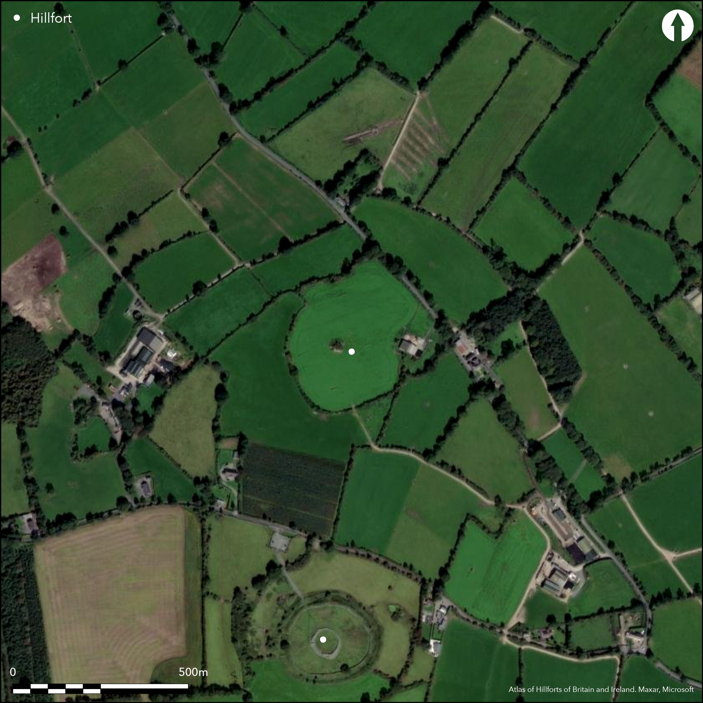
Possible multiple enclosure positioned surrounding the low-domed summit of hilltop. Circular fort follows contours of hill and takes advantage of steep break of slope to N. It has a total site footprint of 6.2ha and is positioned 300m to the N of the large multiple enclosure of Rathgall (Atlas No.0723). Aerial photography has suggested that this is a bivallate multiple enclosure with widely spaced enclosing elements separated by approximately 50m. This has been confirmed by geophysics. There are three breaks through the inner enclosing elements that are probably modern. Large cairn positioned at the centre and highest point of the hillfort. Geophysical survey has identified up to twenty possible hut structures within the interior of the inner enclosing elements and possible pits and relict field systems have also been identified (O'Driscoll 2014). Ramparts survive well at S and W and are levelled at the N and E. Outer enclosing elements visible in Cambridge University aerial photographs as a vegetation mark. Interior under pasture. Earlier map depiction in first edition Ordnance Survey maps. More detailed depiction in second edition mapping. Geophysical survey by O'Driscoll in 2014.
Citizen Science: ✗
Reliability of Data: Confirmed
Reliability of Interpretation: Confirmed
X: -741656 Y: 6947321 (EPSG: 3857)
Longitude: -6.662413221753728 Latitude: 52.806693203806624 (EPSG:4326)
Country: Republic of Ireland
Current County or Unitary Authority: Wicklow
Historic County: Wicklow
Current Parish/Community/Council/Townland: Knockeen
Inner enclosing elements extant. Possible outer enclosing elements visible as a vegetation mark in aerial photography. in Cambridge University aerial photographs and in geophysics.
| Extant | ✓ |
| Cropmark | ✗ |
| Likely Destroyed | ✓ |
None
| Woodland | ✗ |
| Commercial Forestry Plantation | ✗ |
| Parkland | ✗ |
| Pasture (Grazing) | ✓ |
| Arable | ✗ |
| Scrub/Bracken | ✗ |
| Bare Outcrop | ✗ |
| Heather/Moorland | ✗ |
| Heath | ✗ |
| Built-up | ✗ |
| Coastal Grassland | ✗ |
| Other | ✗ |
Possible multiple enclosure positioned surrounding low-domed summit of hilltop. Fort follows contours of hill and takes advantage of steep break of slope to N. Large multiple enclosure overlooking hillfort 300m to S. Excellent views to N, E and W.
| Contour Fort | ✓ |
| Partial Contour Fort | ✗ |
| Promontory Fort | ✗ |
| Hillslope Fort | ✗ |
| Level Terrain Fort | ✗ |
| Marsh Fort | ✗ |
| Multiple Enclosure Fort | ✓ |
| Hilltop | ✓ |
| Coastal Promontory | ✗ |
| Inland Promontory | ✗ |
| Valley Bottom | ✗ |
| Knoll/Hillock/Outcrop | ✗ |
| Ridge | ✗ |
| Cliff/Plateau-edge/Scarp | ✗ |
| Hillslope | ✗ |
| Lowland | ✗ |
| Spur | ✗ |
Dominant Topographic Feature: Low-domed hilltop.
| North | ✗ |
| Northeast | ✗ |
| East | ✗ |
| Southeast | ✗ |
| South | ✗ |
| Southwest | ✗ |
| West | ✗ |
| Northwest | ✗ |
| Level | ✓ |
Altitude: 123.0m
N/A
No dating evidence.
Reliability: D - None
| Pre 1200BC | ✗ |
| 1200BC - 800BC | ✗ |
| 800BC - 400BC | ✗ |
| 400BC - AD50 | ✗ |
| AD50 - AD400 | ✗ |
| AD400 - AD 800 | ✗ |
| Post AD800 | ✗ |
| Unknown | ✓ |
| Pre Hillfort: | Large cairn at centre of hillfort probably prehistoric. |
| Post Hillfort: | None |
Earlier map detection in first edition Ordnance Survey maps. More detailed depiction in second edition mapping. Geophysical survey by O'Driscoll in 2014.
| 1st Identified Map Depiction (1842): | First edition Ordnance Survey 6 inch mapping. |
| Other (1906): | Second edition Ordnance Survey 25 inch mapping. |
| Geophysical Survey (2014): | Geophysical survey by O'Driscoll 2014. |
A large cairn is positioned at the centre and highest point of the hillfort. Orpen (1911, 142) noted two field fences radiating from the cairn and these have also been identified in Ordnance Survey mapping and geophysical surveys (O'Driscoll 2014). Geophysical survey has also identified up to twenty possible hut sites within the interior and a number of possible pit features (O'Driscoll 2014).
None
| None | ✓ |
| Spring | ✗ |
| Stream | ✗ |
| Pool | ✗ |
| Flush | ✗ |
| Well | ✗ |
| Other | ✗ |
Large cairn
| No Known Features | ✗ |
| Round Stone Structures | ✗ |
| Rectangular Stone Structures | ✗ |
| Curvilinear Platforms | ✗ |
| Other Roundhouse Evidence | ✗ |
| Pits | ✗ |
| Quarry Hollows | ✗ |
| Other | ✓ |
None
| No Known Excavation | ✓ |
| Pits | ✗ |
| Postholes | ✗ |
| Roundhouses | ✗ |
| Rectangular Structures | ✗ |
| Roads/Tracks | ✗ |
| Quarry Hollows | ✗ |
| Other | ✗ |
| Nothing Found | ✗ |
Relict field boundaries, possible round house and pits discovered using geophysics.
| No Known Geophysics | ✗ |
| Pits | ✓ |
| Roundhouses | ✓ |
| Rectangular Structures | ✗ |
| Roads/Tracks | ✗ |
| Quarry Hollows | ✗ |
| Other | ✓ |
| Nothing Found | ✗ |
None
| No Known Finds | ✓ |
| Pottery | ✗ |
| Metal | ✗ |
| Metalworking | ✗ |
| Human Bones | ✗ |
| Animal Bones | ✗ |
| Lithics | ✗ |
| Environmental | ✗ |
| Other | ✗ |
NO APPARENT FEATURES
| APs Not Checked | ✗ |
| None | ✓ |
| Roundhouses | ✗ |
| Rectangular Structures | ✗ |
| Pits | ✗ |
| Postholes | ✗ |
| Roads/Tracks | ✗ |
| Other | ✗ |
No obvious entrance features that could be regarded as original. Three gaps in the inner enclosing elements at the S, W and WNW are likely to be modern.
| 3: | Three modern gaps in inner enclosing element at S, W and WNW. |
| 2: | None |
Guard Chambers: ✗
Chevaux de Frise: ✗
Circular area defined by a bank of earth and stone that has been cleared of growth (Grogan and Kilfeather 1997, 42-43). It has a maximum height of 1.5m and is approximately 5m wide. There is no obvious ditch feature on the surface. Geophysical survey has confirmed the presence of an in-filled external ditch. The enclosing elements have been destroyed at the N and E. These have been traced by geophysics, confirming that these have been destroyed in these areas (O'Driscoll 2014). Possible outer enclosing element identified as a concentric cropmark approximately 50m outside the inner example and confirmed by geophysics.
| Area 1: | 3.14ha. |
| Area 2: | 6.22ha. |
| Total: | 6.22ha. |
Total Footprint Area: 6.22ha.
None
| ✗ | None |
| ✓ | Cropmarks indicate that there is a second enclosing element. This is visible at the S, SW and W in Cambridge University aerial photographs. A modern road and farm development have been built over the remaining sections and are therefore not visible. It is likely that the second enclosing elements formed a complete circuit. |
| NE Quadrant: | 1 |
| SE Quadrant: | 1 |
| SW Quadrant: | 2 |
| NW Quadrant: | 1 |
| Total: | 2 |
| Partial Univallate | ✓ |
| Univallate | ✗ |
| Partial Bivallate | ✓ |
| Bivallate | ✗ |
| Partial Multivallate | ✗ |
| Multivallate | ✗ |
| Unknown | ✗ |
| Partial Univallate | ✗ |
| Univallate | ✓ |
| Partial Bivallate | ✗ |
| Bivallate | ✗ |
| Partial Multivallate | ✗ |
| Multivallate | ✗ |
Earth and stone bank
| None | ✗ |
| Earthen Bank | ✓ |
| Stone Wall | ✗ |
| Rubble | ✗ |
| Wall-walk | ✗ |
| Evidence of Timber | ✗ |
| Vitrification | ✗ |
| Other Burning | ✗ |
| Palisade | ✗ |
| Counter Scarp Bank | ✗ |
| Berm | ✗ |
| Unfinished | ✗ |
| Other | ✗ |
None
| None | ✗ |
| Earthen Bank | ✗ |
| Stone Wall | ✗ |
| Murus Duplex | ✗ |
| Timber-framed | ✗ |
| Timber-laced | ✗ |
| Vitrification | ✗ |
| Other Burning | ✗ |
| Palisade | ✗ |
| Counter Scarp Bank | ✗ |
| Berm | ✗ |
| Unfinished | ✗ |
| No Known Excavation | ✓ |
| Other | ✗ |
| ✗ | None |
| ✓ | Geophysics indicate that the inner enclosing element had an external ditch. |
Number of Ditches: 1
| ✗ | None. |
Grogan, E. and Kilfeather, A. 1997. Archaeological Inventory of County Wicklow. The Stationary Office, Dublin.
O'Driscoll, J. 2014. Unpublished geophysical survey report: Knockeen, Co. Wicklow. UCC Cork, Dept of Archaeology.
Orpen, G. 1911. Rathgal, Co. Wicklow. Journal of the Royal Society of Antiquaries of Ireland 41, 138 - 150.
Atlas of Hillforts:
Wikidata:
This work is licensed under CC BY-SA 4.0![]()
![]()
![]() and should be cited as:
and should be cited as:
Lock, Gary and Ralston, Ian. 2024. Atlas of Hillforts of Britain and Ireland. Available at: https://hillforts.arch.ox.ac.uk
Document Version 1.1