Satellite Imagery
Satellite Imagery
HER: Archaeological Survey of Ireland SMR Database WI027-026001 (None)
NMR: WI 027 (None)
SM: None
NGR: None
X: 688416 Y: 689371 (IRENET95)
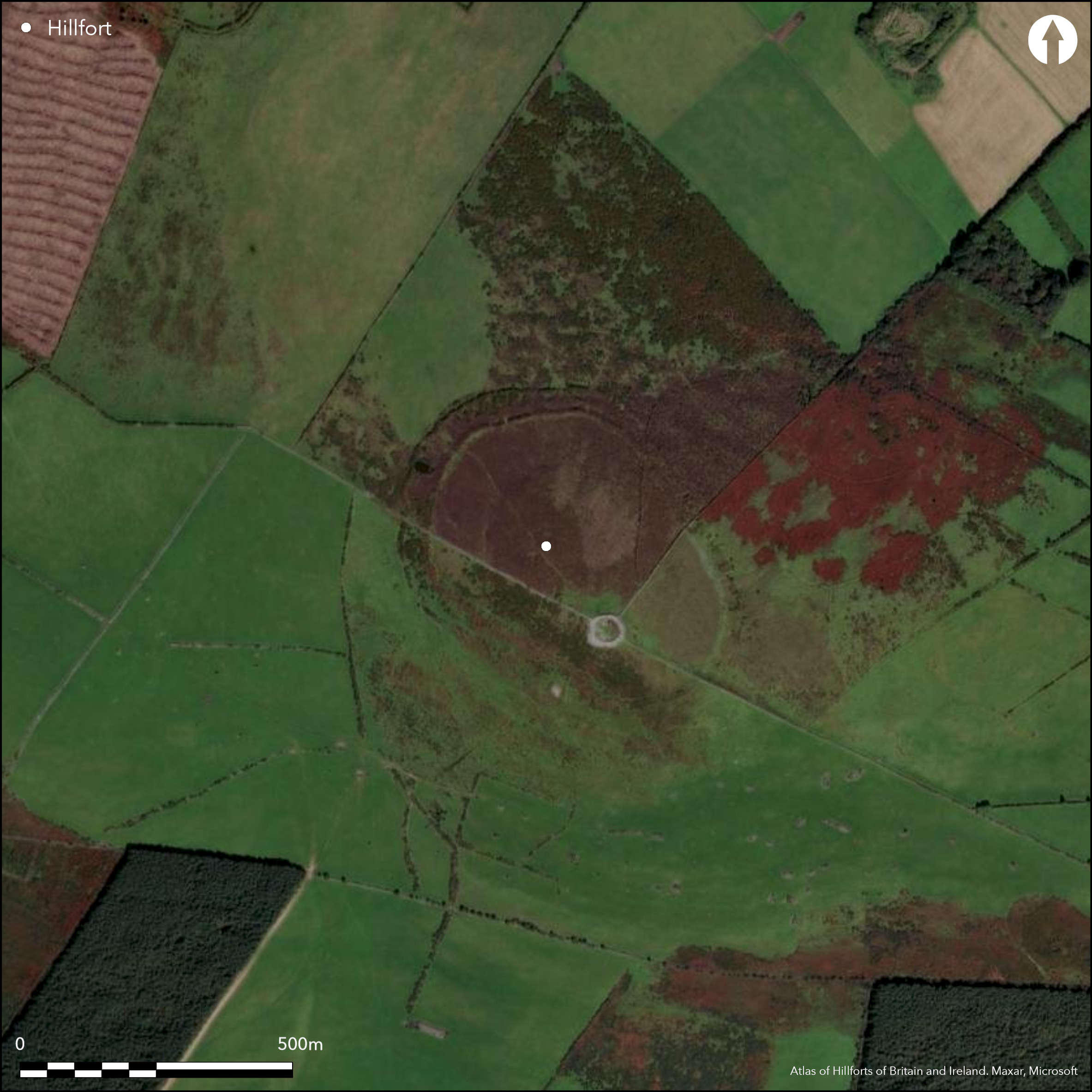
Multiple enclosure positioned on highest summit of Tuckmill Hill. Rathcoran is one of nine hillforts comprising the Baltinglass hillfort cluster. The name Rathcoran probably refers to a large prehistoric cairn at its centre (rath of the cairn). This pear-shaped bi-vallate monument has a total site footprint of approximately 10.1ha. The shape is dictated by the topography of the hill, which the enclosing elements largely follow. There are up to sixteen breaks in the enclosing elements, however, all of these are probably modern. GPS, LiDAR and geophysical survey have identified up to fifty hut structures within the interior. A large Neolithic cairn was excavated within the hilfort interior (Walshe 1941). A second cairn abuts the exterior of the outer enclosing elements at the SE. Geophysical survey has also identified strong magnetic anomalies at the crest of the inner bank at the N, indicative of a possible burnt palisade feature. Waddell (1998) and Condit (1998) have both interpreted Rathcoran as an unfinished hillfort, due to the incomplete nature of the enclosing elements and intervening quarry features. Ramparts are most complete at the N. The interior is under heavy gorse and scrub cover. First map depiction in 1842 in first edition Ordnance Survey mapping. Excavation of Neolithic passage tomb within hillfort by Walshe in late 1930's (Walshe 1941). Survey by Condit in 1992 and 1998. Survey by Grogan and Kilfeather (1997, 41). Geophysical survey by O'Driscoll (in prep.) in 2012. LiDAR survey commissioned by department of archaeology University College Cork. GPS survey by O'Driscoll in 2014.
Citizen Science: ✗
Reliability of Data: Confirmed
Reliability of Interpretation: Confirmed
X: -744101 Y: 6973355 (EPSG: 3857)
Longitude: -6.684371828306659 Latitude: 52.94783896417548 (EPSG:4326)
Country: Republic of Ireland; None
Current County or Unitary Authority: Wicklow
Historic County: Wicklow
Current Parish/Community/Council/Townland: Coolinarrig Upper
None
| Extant | ✓ |
| Cropmark | ✗ |
| Likely Destroyed | ✗ |
None
| Woodland | ✗ |
| Commercial Forestry Plantation | ✗ |
| Parkland | ✗ |
| Pasture (Grazing) | ✗ |
| Arable | ✗ |
| Scrub/Bracken | ✓ |
| Bare Outcrop | ✗ |
| Heather/Moorland | ✗ |
| Heath | ✗ |
| Built-up | ✗ |
| Coastal Grassland | ✗ |
| Other | ✗ |
Multiple enclosure positioned on highest summit of Tuckmill Hill. Tuckmill Hill is a steep tripartite hilltop overlooking the modern town of Baltinglass to the SW. Two other hillforts are positioned on the N and W summit of the hill. Rathcoran hillfort follows the contours of the domed summit of the hill. There are panoramic views from the highest point within the interior. Rathcoran is one of nine hillforts comprising the Baltinglass hillfort cluster.
| Contour Fort | ✓ |
| Partial Contour Fort | ✗ |
| Promontory Fort | ✗ |
| Hillslope Fort | ✗ |
| Level Terrain Fort | ✗ |
| Marsh Fort | ✗ |
| Multiple Enclosure Fort | ✓ |
| Hilltop | ✓ |
| Coastal Promontory | ✗ |
| Inland Promontory | ✗ |
| Valley Bottom | ✗ |
| Knoll/Hillock/Outcrop | ✗ |
| Ridge | ✗ |
| Cliff/Plateau-edge/Scarp | ✗ |
| Hillslope | ✗ |
| Lowland | ✗ |
| Spur | ✗ |
Dominant Topographic Feature: Tuckmill Hill.
| North | ✗ |
| Northeast | ✗ |
| East | ✗ |
| Southeast | ✗ |
| South | ✗ |
| Southwest | ✗ |
| West | ✗ |
| Northwest | ✗ |
| Level | ✓ |
Altitude: 370.0m
The center of the hillfort forms the meeting point of the townland boundaries of Tuckmill Hill, Coolinarrig Upper and Pinnacle.
Boundary Type: Parish/Townland
No dating evidence.
Reliability: D - None
| Pre 1200BC | ✗ |
| 1200BC - 800BC | ✗ |
| 800BC - 400BC | ✗ |
| 400BC - AD50 | ✗ |
| AD50 - AD400 | ✗ |
| AD400 - AD 800 | ✗ |
| Post AD800 | ✗ |
| Unknown | ✓ |
| Pre Hillfort: | Substantial Neolithic passage tomb at summit of hillfort interior excavated by Walshe in late 1930's (Walshe 1941). A second cairn abuts the exterior of the outer enclosing elements at the S. |
| Post Hillfort: | None |
First map depiction in 1842 in first edition Ordnance Survey six inch mapping. More detailed survey in second edition Ordnance Survey 25 inch mapping. Excavation of Neolithic passage tomb within hillfort by Walshe in late 1930's (Walshe 1941). Survey by Condit in 1992 and 1998. Survey by Grogan and Kilfeather (1997, 41). Geophysical survey by O'Driscoll in 2012. LiDAR survey commissioned by department of archaeology University College Cork. GPS survey by O'Driscoll in 2014. Aerial photographs by Cambridge aerial photography unit and GSI.
| 1st Identified Map Depiction (1842): | First edition Ordnance Survey 6 inch mapping |
| Earthwork Survey (1906): | Second edition Ordnance Survey 25 inch mapping |
| Other (1992): | Monument survey by Condit |
| Other (1997): | Monument survey by Grogan and Kilfeather |
| Other (1998): | Monument survey by Condit |
| Geophysical Survey (2012): | Geophysical survey by O'Driscoll |
| LiDAR Survey (2012): | LiDAR survey commissioned by department of archaeology University College Cork. |
| Other (2014): | GPS survey by O'Driscoll |
| Other (None): | Cambridge aerial photography unit. |
| Other (None): | GSI aerial photographs. |
Two recorded hut structures within interior. Neolithic cairn positioned at highest point within hillfort interior excavated by Walshe (1941). Up to 50 hut structures identified by LiDAR and GPS survey by O'Driscoll in 2014. These comprises circular platforms cut into the natural slope of the hill, some of which are defined by a circular setting of stone. Geophysics (O'Driscoll 2012) has confirmed the presence of some of these hut structures.
None
| None | ✓ |
| Spring | ✗ |
| Stream | ✗ |
| Pool | ✗ |
| Flush | ✗ |
| Well | ✗ |
| Other | ✓ |
Cairn on the summit
| No Known Features | ✗ |
| Round Stone Structures | ✓ |
| Rectangular Stone Structures | ✗ |
| Curvilinear Platforms | ✓ |
| Other Roundhouse Evidence | ✗ |
| Pits | ✗ |
| Quarry Hollows | ✗ |
| Other | ✓ |
None
| No Known Excavation | ✓ |
| Pits | ✗ |
| Postholes | ✗ |
| Roundhouses | ✗ |
| Rectangular Structures | ✗ |
| Roads/Tracks | ✗ |
| Quarry Hollows | ✗ |
| Other | ✗ |
| Nothing Found | ✗ |
None
| No Known Geophysics | ✗ |
| Pits | ✓ |
| Roundhouses | ✓ |
| Rectangular Structures | ✗ |
| Roads/Tracks | ✗ |
| Quarry Hollows | ✗ |
| Other | ✗ |
| Nothing Found | ✗ |
None
| No Known Finds | ✓ |
| Pottery | ✗ |
| Metal | ✗ |
| Metalworking | ✗ |
| Human Bones | ✗ |
| Animal Bones | ✗ |
| Lithics | ✗ |
| Environmental | ✗ |
| Other | ✗ |
NO APPARENT FEATURES
| APs Not Checked | ✗ |
| None | ✓ |
| Roundhouses | ✗ |
| Rectangular Structures | ✗ |
| Pits | ✗ |
| Postholes | ✗ |
| Roads/Tracks | ✗ |
| Other | ✗ |
There are a number of possible entrances indicated in the second edition Ordnance Survey map at the N, E, SE and SW. Subsequently, O'Driscoll (2014) has identified up to twelve gaps in the inner and outer enclosing elements, although these are likely to be modern. There is no indication of an original entrance, although Waddell (1998) suggests an original break in the banks is located in the eastern section.
| 16: | None |
| 2: | None |
Guard Chambers: ✗
Chevaux de Frise: ✗
The enclosing elements are most complete at the N and NW, where the inner example is 16m in width and comprises a mixture of earth and stone. Geophysical survey has identified strong magnetic anomalies at the crest of the bank in this area, indicative of a possible burnt palisade feature. The internal enclosure has an average internal height of 1.7m and average external height of 2.6m. The outer enclosing element has an average internal height of 1.3m and an average external height of 2.1m. Here, the banks are separated by approximately 28m (maximum 35m). There is no evidence of an adjacent ditch. To the east, the gap between the enclosing elements narrow to an average of 12m. Although the banks are slighter, the steeply sloping ground enhances the exterior perception. The inner enclosing element is on average 0.8m in height internally but almost 3m in height externally. Similarly, the outer enclosure is 0.4m in average height internally and 2.1m high externally. To the S, a 185m section of the enclosing elements is characterized by closely set multivallation and very slight banks. Quarry pits and associated spoil are visible in many sections between the enclosing elements. Presumably, the material from these pits was used for constructing the banks.
| Area 1: | 7.03ha. |
| Area 2: | 9.61ha. |
| Total: | 9.61ha. |
Total Footprint Area: 10.06ha.
None
| ✗ | Waddell (1998) and Condit (1998) have both interpreted Rathcoran as an unfinished hillfort, due to the incomplete nature of the enclosing elements and intervening quarry features. |
| ✓ | None |
| NE Quadrant: | 2 |
| SE Quadrant: | 2 |
| SW Quadrant: | 2 |
| NW Quadrant: | 2 |
| Total: | 2 |
| Partial Univallate | ✗ |
| Univallate | ✗ |
| Partial Bivallate | ✗ |
| Bivallate | ✓ |
| Partial Multivallate | ✗ |
| Multivallate | ✗ |
| Unknown | ✗ |
| Partial Univallate | ✗ |
| Univallate | ✓ |
| Partial Bivallate | ✗ |
| Bivallate | ✗ |
| Partial Multivallate | ✗ |
| Multivallate | ✗ |
Earth and stone. Suggested unfinished Waddell (1998) and Condit (1998)
| None | ✗ |
| Earthen Bank | ✓ |
| Stone Wall | ✗ |
| Rubble | ✗ |
| Wall-walk | ✗ |
| Evidence of Timber | ✗ |
| Vitrification | ✗ |
| Other Burning | ✗ |
| Palisade | ✗ |
| Counter Scarp Bank | ✗ |
| Berm | ✗ |
| Unfinished | ✓ |
| Other | ✗ |
None
| None | ✗ |
| Earthen Bank | ✗ |
| Stone Wall | ✗ |
| Murus Duplex | ✗ |
| Timber-framed | ✗ |
| Timber-laced | ✗ |
| Vitrification | ✗ |
| Other Burning | ✗ |
| Palisade | ✗ |
| Counter Scarp Bank | ✗ |
| Berm | ✗ |
| Unfinished | ✗ |
| No Known Excavation | ✓ |
| Other | ✗ |
| ✓ | Unfinished quarry pits and their associated spoil may be evidence for gang working. |
| ✗ | None |
Number of Ditches: 0
| ✗ | None. |
Condit, T. 1992. Ireland's hillfort capital: Baltinglass, Co. Wicklow. Archaeology Ireland, 6 (3), 16-20.
Condit, T. 1998. Observations of the Baltinglass hillfort complex. Wicklow: Archaeology and History, 1, 9-25.
Grogan, E. and Kilfeather, A. 1997. Archaeological Inventory of County Wicklow. The Stationary Office, Dublin.
O'Driscoll, J. 2012. Unpublished geophysical survey report: Rathcoran, Co. Wicklow. UCC Cork, Dept of Archaeology.
O'Driscoll, J. 2014. Unpublished GPS survey report: Rathcoran, Co. Wicklow. UCC Cork, Dept of Archaeology.
Walshe, P. 1941. The excavation of a burial cairn on Baltinglass Hill, Co. Wicklow. Proceedings of the Royal Irish Academy, 46, 221-236.
Waddell, J. 1998. The Prehistoric Archaeology of Ireland, 1st edn. Wordwell, Dublin.
Atlas of Hillforts:
Wikidata:
This work is licensed under CC BY-SA 4.0![]()
![]()
![]() and should be cited as:
and should be cited as:
Lock, Gary and Ralston, Ian. 2024. Atlas of Hillforts of Britain and Ireland. Available at: https://hillforts.arch.ox.ac.uk
Document Version 1.1