Satellite Imagery
Satellite Imagery
HER: Archaeological Survey of Ireland SMR Database WI027-010 (None)
NMR: WI 027 (None)
SM: None
NGR: None
X: 688005 Y: 690013 (IRENET95)
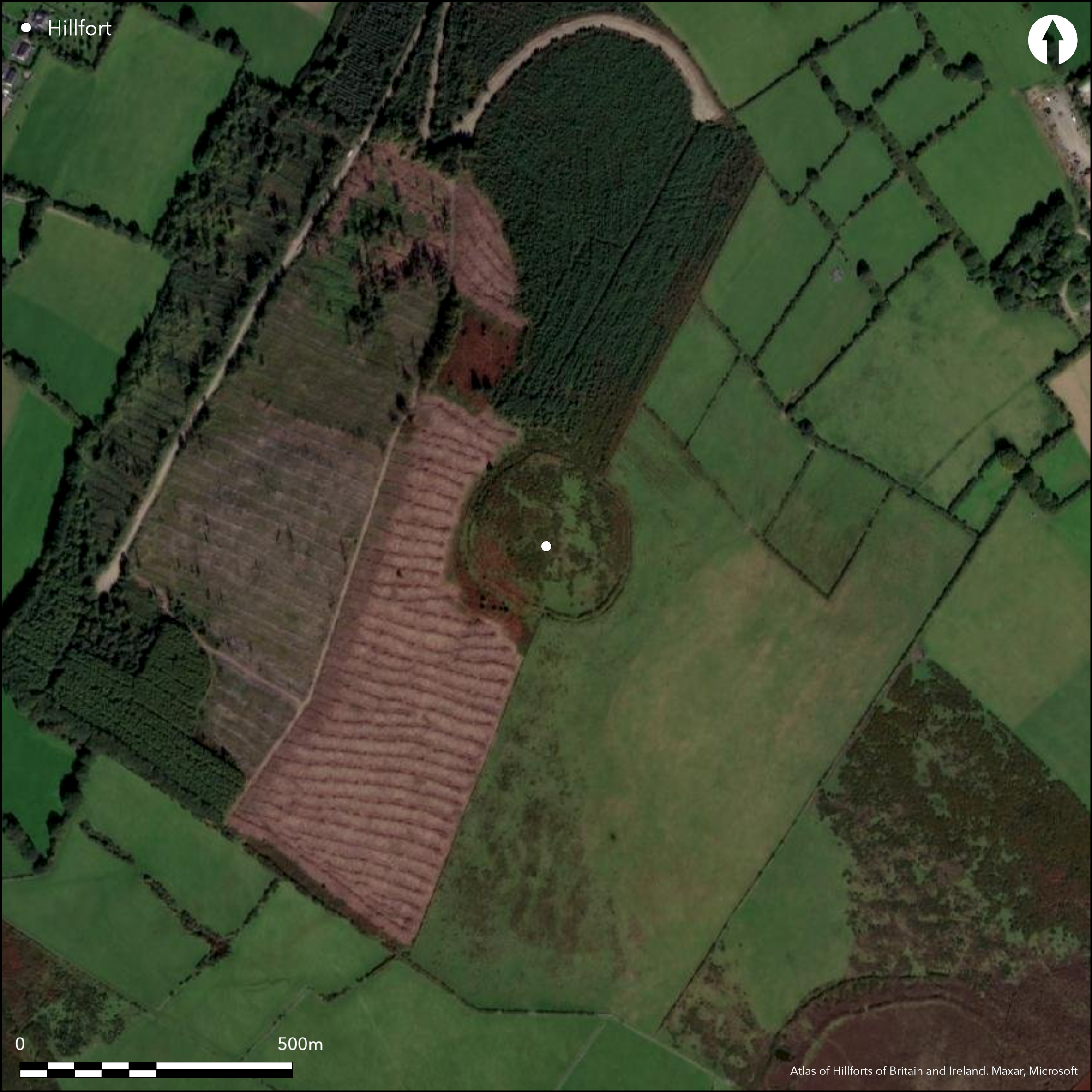
Multiple enclosure positioned on a northern spur of Tuckmill Hill, 400m NNW of Rathcoran hillfort. Rathnagree is one of nine hillforts comprising the Baltinglass hillfort cluster. The name Rathnagree translates as Çrath of the king'. It has a total site footprint of 5.8ha and comprises three widely spaced enclosing elements. The enclosing elements do not follow the contours of the hill. The ramparts disregard topographical variation to form three circular enclosures. There are two possible original entrances in the middle enclosing elements at the NNE and N. These comprise simple gaps in the enclosing elements. No evidence for any internal features on the surface. Ramparts survive best at N, NE and NW. Commercial woodland encroaches on the enclosing elements at the N and NE. Geophysical survey suggests that the low rise stone banks of the inner and outer enclosing elements formed the footings for timber palisades (O'Driscoll 2012). This has recently been confirmed by excavation. First map depiction in 1842 in first edition Ordnance Survey mapping. Survey by Condit in 1992 and 1998. Survey by Grogan and Kilfeather (1997, 41). Geophysical survey by O'Driscoll in 2012. LiDAR survey commissioned by department of archaeology University College Cork. Excavation by O'Brien in 2014. Late Bronze Age coarse ware pottery was obtained from the ditch fill of the middle enclosing element.
Citizen Science: ✗
Reliability of Data: Confirmed
Reliability of Interpretation: Confirmed
X: -744762 Y: 6974434 (EPSG: 3857)
Longitude: -6.690311488965251 Latitude: 52.95367497802862 (EPSG:4326)
Country: Republic of Ireland; None
Current County or Unitary Authority: Wicklow
Historic County: Wicklow
Current Parish/Community/Council/Townland: Tuckmill Upper
None
| Extant | ✓ |
| Cropmark | ✗ |
| Likely Destroyed | ✗ |
None
| Woodland | ✗ |
| Commercial Forestry Plantation | ✓ |
| Parkland | ✗ |
| Pasture (Grazing) | ✓ |
| Arable | ✗ |
| Scrub/Bracken | ✓ |
| Bare Outcrop | ✗ |
| Heather/Moorland | ✗ |
| Heath | ✗ |
| Built-up | ✗ |
| Coastal Grassland | ✗ |
| Other | ✗ |
Multiple enclosure surrounding the N ridge of Tuckmill Hill, a steep tripartite hilltop overlooking the modern town of Baltinglass to the SW. Two other hillforts are positioned on the S and W summit of the hill. The hillfort does not follow the contours of the hill. The ramparts disregard topographical variation to form three circular enclosures. Rathnagree is one of nine hillforts comprising the Baltinglass hillfort cluster.
| Contour Fort | ✗ |
| Partial Contour Fort | ✓ |
| Promontory Fort | ✗ |
| Hillslope Fort | ✗ |
| Level Terrain Fort | ✗ |
| Marsh Fort | ✗ |
| Multiple Enclosure Fort | ✓ |
| Hilltop | ✗ |
| Coastal Promontory | ✗ |
| Inland Promontory | ✗ |
| Valley Bottom | ✗ |
| Knoll/Hillock/Outcrop | ✗ |
| Ridge | ✓ |
| Cliff/Plateau-edge/Scarp | ✗ |
| Hillslope | ✗ |
| Lowland | ✗ |
| Spur | ✓ |
Dominant Topographic Feature: Ridge.
| North | ✗ |
| Northeast | ✗ |
| East | ✗ |
| Southeast | ✗ |
| South | ✗ |
| Southwest | ✗ |
| West | ✗ |
| Northwest | ✗ |
| Level | ✓ |
Altitude: 326.0m
The E section of the middle enclosing elements form the boundary between the townlands of Tuckmill Upper and Tuckmill Hill.
Boundary Type: Parish/Townland
Recent excavation recovered Late Bronze Age coarse ware pottery from the ditch of the middle enclosing elements. Radiocarbon dates for the three enclosing elements will be available soon.
Reliability: C - Low
| Pre 1200BC | ✗ |
| 1200BC - 800BC | ✗ |
| 800BC - 400BC | ✗ |
| 400BC - AD50 | ✗ |
| AD50 - AD400 | ✗ |
| AD400 - AD 800 | ✗ |
| Post AD800 | ✗ |
| Unknown | ✓ |
| Pre Hillfort: | None |
| Post Hillfort: | None |
| Artefactual: | Diagnostic Late Bronze Age pottery. |
First map depiction in 1842 in first edition Ordnance Survey six inch mapping. More detailed survey in second edition Ordnance Survey 25 inch mapping. Survey by Condit in 1992 and 1998. Survey by Grogan and Kilfeather (1997, 41). Geophysical survey by O'Driscoll (in prep.) in 2012. LiDAR survey commissioned by department of archaeology University College Cork. Aerial photography from the Cambridge aerial photographic unit in the 1960's. Aerial photography from the GSI.
| 1st Identified Map Depiction (1842): | First edition Ordnance Survey 6 inch mapping |
| Earthwork Survey (1905): | Second edition Ordnance Survey 25 inch mapping |
| Other (1992): | Monument survey by Condit |
| Other (1997): | Monument survey by Grogan and Kilfeather |
| Other (1998): | Monument survey by Condit |
| Geophysical Survey (2012): | Geophysical survey by O'Driscoll |
| LiDAR Survey (2012): | LiDAR survey commissioned by department of archaeology University College Cork. |
| Other (None): | Cambridge aerial photographic unit. |
| Other (None): | GSI aerial photographs. |
No evidence for any internal features on the surface.
None
| None | ✓ |
| Spring | ✗ |
| Stream | ✗ |
| Pool | ✗ |
| Flush | ✗ |
| Well | ✗ |
| Other | ✗ |
None
| No Known Features | ✓ |
| Round Stone Structures | ✗ |
| Rectangular Stone Structures | ✗ |
| Curvilinear Platforms | ✗ |
| Other Roundhouse Evidence | ✗ |
| Pits | ✗ |
| Quarry Hollows | ✗ |
| Other | ✗ |
None
| No Known Excavation | ✓ |
| Pits | ✗ |
| Postholes | ✗ |
| Roundhouses | ✗ |
| Rectangular Structures | ✗ |
| Roads/Tracks | ✗ |
| Quarry Hollows | ✗ |
| Other | ✗ |
| Nothing Found | ✗ |
No features of archaeological significance identified within the interior.
| No Known Geophysics | ✗ |
| Pits | ✗ |
| Roundhouses | ✗ |
| Rectangular Structures | ✗ |
| Roads/Tracks | ✗ |
| Quarry Hollows | ✗ |
| Other | ✗ |
| Nothing Found | ✓ |
Late Bronze Age pottery found in the ditch of the middle enclosing elements. Post holes also identified.
| No Known Finds | ✗ |
| Pottery | ✓ |
| Metal | ✗ |
| Metalworking | ✗ |
| Human Bones | ✗ |
| Animal Bones | ✗ |
| Lithics | ✗ |
| Environmental | ✗ |
| Other | ✗ |
NO APPARENT FEATURES
| APs Not Checked | ✗ |
| None | ✓ |
| Roundhouses | ✗ |
| Rectangular Structures | ✗ |
| Pits | ✗ |
| Postholes | ✗ |
| Roads/Tracks | ✗ |
| Other | ✗ |
There are two possible original entrances in the middle enclosing elements at the NNE and N. These comprise simple gaps in the enclosing elements with causeways over the ditch. The terminals of the E example may be stone faced.
| 2: | None |
| 2: | None |
Guard Chambers: ✗
Chevaux de Frise: ✗
| 1. Simple Gap (North): | None |
| 1. Simple Gap (North east): | None |
Circular area defined by three enclosing elements. The inner and middle features are separated by approximately 37m. The middle and outer examples are 35m apart. The enclosing elements do not have a uniform composition. The middle enclosure is the most impressive of the three. It comprises a well preserved inner bank, outer ditch and counterscarp bank best preserved to the south. The bank and counterscarp are composed mainly of earth. The height of the bank ranges from 2.4m _ 0.5m and is on average 7m wide. The ditch ranges from 2.9m _ 1.3m in depth from the top of the inner bank to bottom of the ditch and is on average 7m wide. The counterscarp ranges from 0.4m _ 0.9m in height and is on average 3m wide. There is no evidence for stone revetment, although recent excavation suggests that this may have originally been present. A large number of small breaks occur throughout the perimeter, although these are most likely modern. Recent excavation suggests that the earthen bank and ditch was constructed over a palisaded enclosure which may have been similar to the inner and outer enclosing elements. The inner rampart comprises a low-rise rubble stone bank with no corresponding ditch. The bank is on average 0.2m in height and 6m wide. Geophysical survey has suggested that the inner and outer enclosing elements were used as the footings for large timber palisades (O'Driscoll 2012). This has been confirmed by excavation (O'Brien 2014).
| Area 1: | 0.69ha. |
| Area 2: | 2.57ha. |
| Area 3: | 5.55ha. |
| Total: | 5.55ha. |
Total Footprint Area: 5.78ha.
None
| ✗ | None |
| ✓ | None |
| NE Quadrant: | 3 |
| SE Quadrant: | 3 |
| SW Quadrant: | 3 |
| NW Quadrant: | 3 |
| Total: | 3 |
| Partial Univallate | ✗ |
| Univallate | ✗ |
| Partial Bivallate | ✗ |
| Bivallate | ✗ |
| Partial Multivallate | ✗ |
| Multivallate | ✓ |
| Unknown | ✗ |
| Partial Univallate | ✗ |
| Univallate | ✓ |
| Partial Bivallate | ✗ |
| Bivallate | ✗ |
| Partial Multivallate | ✗ |
| Multivallate | ✗ |
None
| None | ✗ |
| Earthen Bank | ✓ |
| Stone Wall | ✗ |
| Rubble | ✓ |
| Wall-walk | ✗ |
| Evidence of Timber | ✗ |
| Vitrification | ✗ |
| Other Burning | ✗ |
| Palisade | ✗ |
| Counter Scarp Bank | ✓ |
| Berm | ✗ |
| Unfinished | ✗ |
| Other | ✗ |
Pos stone revetted
| None | ✗ |
| Earthen Bank | ✓ |
| Stone Wall | ✗ |
| Murus Duplex | ✗ |
| Timber-framed | ✗ |
| Timber-laced | ✗ |
| Vitrification | ✗ |
| Other Burning | ✗ |
| Palisade | ✓ |
| Counter Scarp Bank | ✗ |
| Berm | ✗ |
| Unfinished | ✗ |
| No Known Excavation | ✗ |
| Other | ✗ |
| ✗ | None |
| ✓ | External ditch associated with the middle enclosing elements. |
Number of Ditches: 1
| ✗ | None. |
Condit, T. 1992. Ireland's hillfort capital: Baltinglass, Co. Wicklow. Archaeology Ireland, 6 (3), 16-20.
Condit, T. 1998. Observations of the Baltinglass hillfort complex. Wicklow: Archaeology and History, 1, 9-25.
Grogan, E. and Kilfeather, A. 1997. Archaeological Inventory of County Wicklow. The Stationary Office, Dublin.
O'Brien, W. 2014. Unpublished excavation report: Rathnagree, Co. Wicklow. UCC Cork, Dept of Archaeology.
O'Driscoll, J. 2012. Unpublished geophysical survey report: Rathnagree, Co. Wicklow. UCC Cork, Dept of Archaeology.
Atlas of Hillforts:
Wikidata:
This work is licensed under CC BY-SA 4.0![]()
![]()
![]() and should be cited as:
and should be cited as:
Lock, Gary and Ralston, Ian. 2024. Atlas of Hillforts of Britain and Ireland. Available at: https://hillforts.arch.ox.ac.uk
Document Version 1.1