Satellite Imagery
Satellite Imagery
HER: Archaeological Survey of Ireland SMR Database WI026-004 (None)
NMR: WI 026 (None)
SM: None
NGR: None
X: 685167 Y: 690577 (IRENET95)
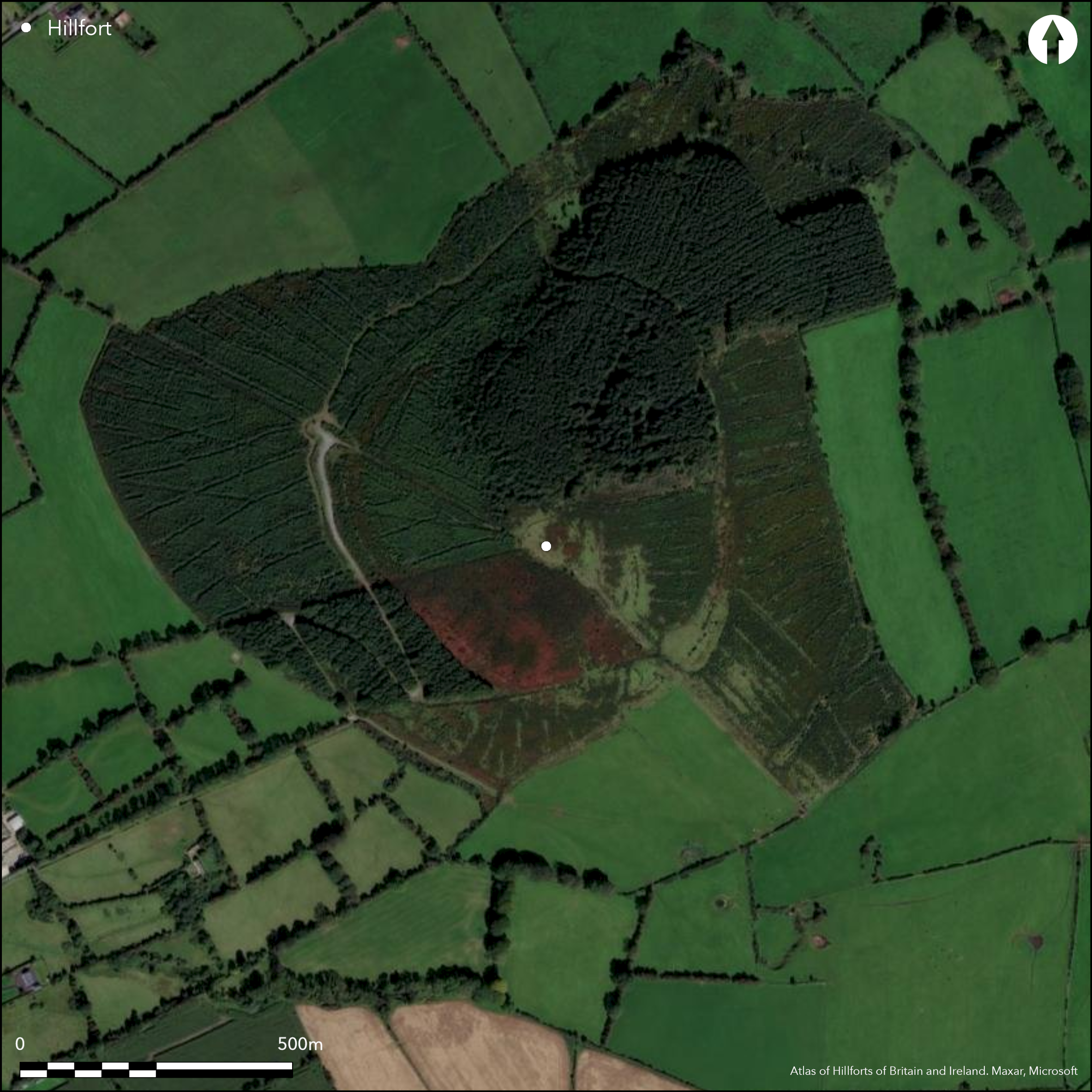
Multiple enclosure in commanding position surrounding domed summit of Tinoran Hill. Tinoran hillfort is the second largest hillfort in Ireland with a total site footprint of approximately 84ha. It is one of nine hillforts comprising the Baltinglass hillfort cluster. Tinoran can be translated as Çhouse of Odhr_n'. It comprises up to four widely spaced enclosing elements and a central enclosure placed at its summit. These do not form complete circuits, but it is likely that they once did. There are no recorded entrance features. A single hut structure is located within the hillfort and a large ring-barrow abuts the outer enclosing element. Ramparts have been heavily disturbed by a commercial forestry plantation which covers most of this large hillfort. First map identification in second edition Ordnance Survey mapping. Monument survey by Condit in 1992 and 1998. Monument survey by Grogan and Kilfeather in 1997. LiDAR survey the OSI.
Citizen Science: ✗
Reliability of Data: Confirmed
Reliability of Interpretation: Confirmed
X: -749446 Y: 6975455 (EPSG: 3857)
Longitude: -6.732386867379433 Latitude: 52.95920051016891 (EPSG:4326)
Country: Republic of Ireland; None
Current County or Unitary Authority: Wicklow
Historic County: Wicklow
Current Parish/Community/Council/Townland: Tinoran
Much of the hillfort is under commercial forestry plantation and has been severely affected by the planting, harvesting and replanting of this these trees.
| Extant | ✓ |
| Cropmark | ✗ |
| Likely Destroyed | ✓ |
None
| Woodland | ✗ |
| Commercial Forestry Plantation | ✓ |
| Parkland | ✗ |
| Pasture (Grazing) | ✓ |
| Arable | ✗ |
| Scrub/Bracken | ✗ |
| Bare Outcrop | ✗ |
| Heather/Moorland | ✗ |
| Heath | ✗ |
| Built-up | ✗ |
| Coastal Grassland | ✗ |
| Other | ✗ |
Multiple enclosure in commanding position surrounding domed summit of Tinoran Hill. This summit is located on the N edge of a N - S running hill ridge overlooking the River Slaney immediately to the E. Tinoran is one of nine hillforts comprising the Baltinglass hillfort cluster.
| Contour Fort | ✓ |
| Partial Contour Fort | ✗ |
| Promontory Fort | ✗ |
| Hillslope Fort | ✗ |
| Level Terrain Fort | ✗ |
| Marsh Fort | ✗ |
| Multiple Enclosure Fort | ✓ |
| Hilltop | ✓ |
| Coastal Promontory | ✗ |
| Inland Promontory | ✗ |
| Valley Bottom | ✗ |
| Knoll/Hillock/Outcrop | ✗ |
| Ridge | ✗ |
| Cliff/Plateau-edge/Scarp | ✗ |
| Hillslope | ✗ |
| Lowland | ✗ |
| Spur | ✗ |
Dominant Topographic Feature: Tinoran Hill.
| North | ✗ |
| Northeast | ✗ |
| East | ✗ |
| Southeast | ✗ |
| South | ✗ |
| Southwest | ✗ |
| West | ✗ |
| Northwest | ✗ |
| Level | ✓ |
Altitude: 312.0m
The center of the hillfort is bisected by the boundary between the townlands of Tinoran Hill North and Tinoran Hill South.
Boundary Type: Parish/Townland
No dating evidence.
Reliability: D - None
| Pre 1200BC | ✗ |
| 1200BC - 800BC | ✗ |
| 800BC - 400BC | ✗ |
| 400BC - AD50 | ✗ |
| AD50 - AD400 | ✗ |
| AD400 - AD 800 | ✗ |
| Post AD800 | ✗ |
| Unknown | ✓ |
| Pre Hillfort: | None |
| Post Hillfort: | None |
First map identification in second edition Ordnance Survey mapping. Monument survey by Condit in 1992 and 1998. Monument survey by Grogan and Kilfeather in 1997. LiDAR by OSI
| Other (1902): | Monument survey by Condit. |
| Other (1906): | Second edition Ordnance Survey 25 inch mapping. |
| Other (1997): | Monument survey by Grogan and Kilfeather. |
| Other (1998): | Monument survey by Condit. |
| LiDAR Survey (None): | OSI. |
Immediately outside the second inner enclosing element is a D-shaped hut structure (Grogan and Kilfeather 1997, 43). A large ring-barrow abuts the outer enclosure to the east (Grogan and Kilfeather 1997, 43).
None
| None | ✓ |
| Spring | ✗ |
| Stream | ✗ |
| Pool | ✗ |
| Flush | ✗ |
| Well | ✗ |
| Other | ✗ |
single D-shaped hut structure
| No Known Features | ✗ |
| Round Stone Structures | ✓ |
| Rectangular Stone Structures | ✗ |
| Curvilinear Platforms | ✗ |
| Other Roundhouse Evidence | ✗ |
| Pits | ✗ |
| Quarry Hollows | ✗ |
| Other | ✗ |
None
| No Known Excavation | ✓ |
| Pits | ✗ |
| Postholes | ✗ |
| Roundhouses | ✗ |
| Rectangular Structures | ✗ |
| Roads/Tracks | ✗ |
| Quarry Hollows | ✗ |
| Other | ✗ |
| Nothing Found | ✗ |
None
| No Known Geophysics | ✓ |
| Pits | ✗ |
| Roundhouses | ✗ |
| Rectangular Structures | ✗ |
| Roads/Tracks | ✗ |
| Quarry Hollows | ✗ |
| Other | ✗ |
| Nothing Found | ✗ |
None
| No Known Finds | ✓ |
| Pottery | ✗ |
| Metal | ✗ |
| Metalworking | ✗ |
| Human Bones | ✗ |
| Animal Bones | ✗ |
| Lithics | ✗ |
| Environmental | ✗ |
| Other | ✗ |
NO APPARENT FEATURES
| APs Not Checked | ✗ |
| None | ✓ |
| Roundhouses | ✗ |
| Rectangular Structures | ✗ |
| Pits | ✗ |
| Postholes | ✗ |
| Roads/Tracks | ✗ |
| Other | ✗ |
No obvious entrance features recorded.
| 0: | None |
| 2: | None |
Guard Chambers: ✗
Chevaux de Frise: ✗
At the summit of the hillfort is an enclosure comprising an earthen bank 2.2m in average width and 0.9 _ 1.2m in height. The exterior face is stone revetted. There is a ditch immediately outside this bank 1.6m wide and 0.8m deep and is best preserved to the SSW. These features enclose an area of 0.062ha. This is probably an Early Medieval ringfort and is probably not contemporary with the hillfort. The inner enclosing element of the hillfort is oval in shape and surrounds an area of 4.67ha. The second enclosing element is located 65_127m outside of the first enclosure. The southern half of this enclosure has been incorporated into a field wall which is largely responsible for its survival. It occupies an area of 14.46ha. The partial remains of a third enclosing element has been identified through aerial photography (Condit 1998, 15). The southern half of this enclosure survives as a low-rise bank feature on agricultural land rather than forestry. When projected, the enclosure occupies an area of 55.74ha. LiDAR has identified a possible fourth enclosure, approximately 90m from the outside the former example. This is best preserved at the south where it survives as a low-rise bank 11.6m in maximum width. When projected, this bank may enclose an area of 84.03ha.
| Area 1: | 4.67ha. |
| Area 2: | 14.46ha. |
| Area 3: | 55.74ha. |
| Area 4: | 84ha. |
| Total: | 84.0ha. |
Total Footprint Area: 84.03ha.
None
| ✗ | None |
| ✗ | The enclosing elements have been heavily affected by commercial forestry plantation and agricultural practices and are likely to have formed complete circuits. |
| NE Quadrant: | 2 |
| SE Quadrant: | 5 |
| SW Quadrant: | 3 |
| NW Quadrant: | 2 |
| Total: | 5 |
| Partial Univallate | ✗ |
| Univallate | ✗ |
| Partial Bivallate | ✓ |
| Bivallate | ✗ |
| Partial Multivallate | ✓ |
| Multivallate | ✗ |
| Unknown | ✗ |
| Partial Univallate | ✗ |
| Univallate | ✓ |
| Partial Bivallate | ✗ |
| Bivallate | ✗ |
| Partial Multivallate | ✗ |
| Multivallate | ✗ |
None
| None | ✗ |
| Earthen Bank | ✓ |
| Stone Wall | ✗ |
| Rubble | ✗ |
| Wall-walk | ✗ |
| Evidence of Timber | ✗ |
| Vitrification | ✗ |
| Other Burning | ✗ |
| Palisade | ✗ |
| Counter Scarp Bank | ✗ |
| Berm | ✗ |
| Unfinished | ✗ |
| Other | ✗ |
None
| None | ✗ |
| Earthen Bank | ✗ |
| Stone Wall | ✗ |
| Murus Duplex | ✗ |
| Timber-framed | ✗ |
| Timber-laced | ✗ |
| Vitrification | ✗ |
| Other Burning | ✗ |
| Palisade | ✗ |
| Counter Scarp Bank | ✗ |
| Berm | ✗ |
| Unfinished | ✗ |
| No Known Excavation | ✓ |
| Other | ✗ |
| ✗ | None |
| ✓ | Exterior ditch associated with the inner enclosing element. |
Number of Ditches: 1
| ✗ | None. |
Condit, T. 1992. Ireland's hillfort capital: Baltinglass, Co. Wicklow. Archaeology Ireland, 6 (3), 16-20.
Condit, T. 1998. Observations of the Baltinglass hillfort complex. Wicklow: Archaeology and History, 1, 9-25.
Grogan, E. and Kilfeather, A. 1997. Archaeological Inventory of County Wicklow. The Stationary Office, Dublin.
Atlas of Hillforts:
Wikidata:
This work is licensed under CC BY-SA 4.0![]()
![]()
![]() and should be cited as:
and should be cited as:
Lock, Gary and Ralston, Ian. 2024. Atlas of Hillforts of Britain and Ireland. Available at: https://hillforts.arch.ox.ac.uk
Document Version 1.1