Satellite Imagery
Satellite Imagery
HER: Archaeological Survey of Ireland SMR Database WA027-037 (None)
NMR: WA 027 (None)
SM: None
NGR: None
X: 662918 Y: 598476 (IRENET95)
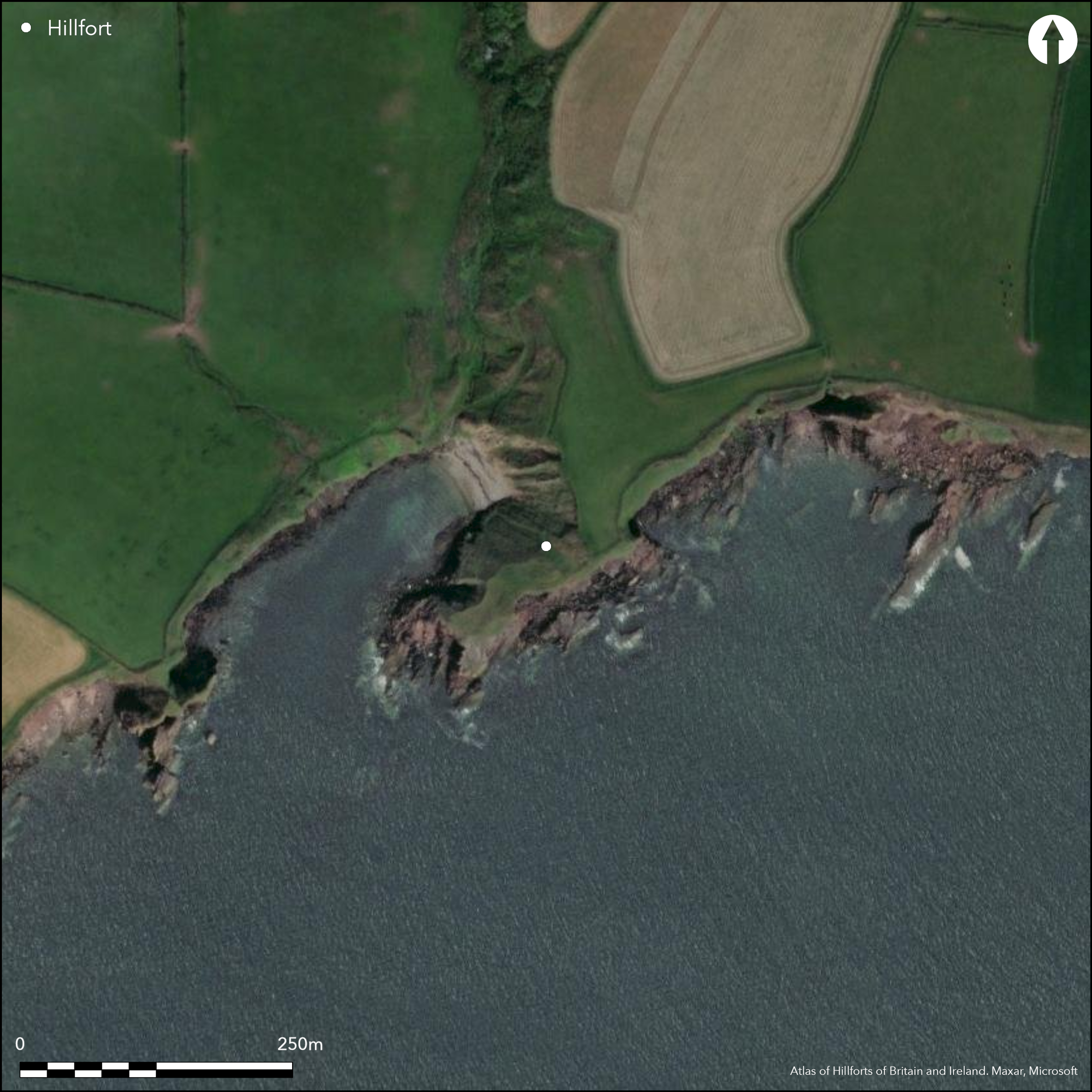
The site is located at Beenlea Head, c. 5km SE of Tramore on the SE coast of Co. Waterford. Marked as an ÇEntrenchment' on the first edition OS map (1840), it is situated adjacent to Cloonliamgowel Cove on a triangular grass-covered promontory (63m ENE-WSW; by12m NNW-SSE) projecting SW from the mainland at an altitude of 6m OD. It is defended by three earthen banks with two intervening ditches that extend across the promontory from NW to SE for c. 23m. The inner bank is 9.5m in width and 1.65m in height internally. It is associated with an outer flat-bottomed ditch measuring 3.7m in width at the base. A low central bank measures 5.9m in width, while an external ditch (Wth of base 2.2m), and an outer bank (Wth 7.5m; ext. H 1.8m) are also recorded. Entrances are situated at the centre of the outer bank and at the S end of the inner bank with average widths of 2.7m. Power (1906, 24-5) describes stone on the inner face of the bank, but this was absent when Westropp (1914-16, 216) described it. There are no recorded internal features and the site is currently under pasture.
Citizen Science: ✗
Reliability of Data: Confirmed
Reliability of Interpretation: Confirmed
X: -788246 Y: 6824493 (EPSG: 3857)
Longitude: -7.080937049593728 Latitude: 52.134562335927725 (EPSG:4326)
Country: Republic of Ireland
Current County or Unitary Authority: Waterford
Historic County: Waterford
Current Parish/Community/Council/Townland: Coolum
None
| Extant | ✓ |
| Cropmark | ✗ |
| Likely Destroyed | ✗ |
None
| Woodland | ✗ |
| Commercial Forestry Plantation | ✗ |
| Parkland | ✗ |
| Pasture (Grazing) | ✓ |
| Arable | ✗ |
| Scrub/Bracken | ✗ |
| Bare Outcrop | ✗ |
| Heather/Moorland | ✗ |
| Heath | ✗ |
| Built-up | ✗ |
| Coastal Grassland | ✗ |
| Other | ✗ |
Situated on a triangular grass-covered promontory projecting SW from the mainland and defended by three earthen banks with two intervening ditches at an altitude of 6m OD.
| Contour Fort | ✗ |
| Partial Contour Fort | ✗ |
| Promontory Fort | ✓ |
| Hillslope Fort | ✗ |
| Level Terrain Fort | ✗ |
| Marsh Fort | ✗ |
| Multiple Enclosure Fort | ✗ |
| Hilltop | ✗ |
| Coastal Promontory | ✓ |
| Inland Promontory | ✗ |
| Valley Bottom | ✗ |
| Knoll/Hillock/Outcrop | ✗ |
| Ridge | ✗ |
| Cliff/Plateau-edge/Scarp | ✗ |
| Hillslope | ✗ |
| Lowland | ✗ |
| Spur | ✗ |
Dominant Topographic Feature: SW-facing promontory
| North | ✗ |
| Northeast | ✗ |
| East | ✗ |
| Southeast | ✗ |
| South | ✗ |
| Southwest | ✓ |
| West | ✗ |
| Northwest | ✗ |
| Level | ✗ |
Altitude: 6.0m
N/A
None
Reliability: D - None
| Pre 1200BC | ✗ |
| 1200BC - 800BC | ✗ |
| 800BC - 400BC | ✗ |
| 400BC - AD50 | ✗ |
| AD50 - AD400 | ✗ |
| AD400 - AD 800 | ✗ |
| Post AD800 | ✗ |
| Unknown | ✓ |
| Pre Hillfort: | None |
| Post Hillfort: | None |
Site depicted as 'Entrenchment' on first edition six-inch OS map (1840). Visited by Power in 1906 who describes stone faced banks, subsequently robbed by local farmers (Power 1906, 24). Surveyed by Westrop in 1914 who notes 'fosse of unusual depth and size'. Site inspected in 1989 for the compilation of the Archaeological Inventory of County Waterford (Moore 1999, 65).
| 1st Identified Map Depiction (1840): | OS six-inch mapping |
| 1st Identified Written Reference (1906): | Power |
| Earthwork Survey (1914): | Westropp |
| Earthwork Survey (1989): | Moore |
There is no recorded internal features
None
| None | ✓ |
| Spring | ✗ |
| Stream | ✗ |
| Pool | ✗ |
| Flush | ✗ |
| Well | ✗ |
| Other | ✗ |
None
| No Known Features | ✓ |
| Round Stone Structures | ✗ |
| Rectangular Stone Structures | ✗ |
| Curvilinear Platforms | ✗ |
| Other Roundhouse Evidence | ✗ |
| Pits | ✗ |
| Quarry Hollows | ✗ |
| Other | ✗ |
None
| No Known Excavation | ✓ |
| Pits | ✗ |
| Postholes | ✗ |
| Roundhouses | ✗ |
| Rectangular Structures | ✗ |
| Roads/Tracks | ✗ |
| Quarry Hollows | ✗ |
| Other | ✗ |
| Nothing Found | ✗ |
None
| No Known Geophysics | ✓ |
| Pits | ✗ |
| Roundhouses | ✗ |
| Rectangular Structures | ✗ |
| Roads/Tracks | ✗ |
| Quarry Hollows | ✗ |
| Other | ✗ |
| Nothing Found | ✗ |
None
| No Known Finds | ✓ |
| Pottery | ✗ |
| Metal | ✗ |
| Metalworking | ✗ |
| Human Bones | ✗ |
| Animal Bones | ✗ |
| Lithics | ✗ |
| Environmental | ✗ |
| Other | ✗ |
NO APPARENT FEATURES
| APs Not Checked | ✗ |
| None | ✓ |
| Roundhouses | ✗ |
| Rectangular Structures | ✗ |
| Pits | ✗ |
| Postholes | ✗ |
| Roads/Tracks | ✗ |
| Other | ✗ |
Entrances, consisting of simple gaps, recorded towards the centre of the outer bank and at the S end of the inner bank (average Wth 2.7m).
| 1: | Only access is across the neck on the NE |
| 2: | It cannot be confirmed whether these were original entrance features. |
Guard Chambers: ✗
Chevaux de Frise: ✗
| 1. Simple Gap (North east): | Through centre of outer rampart |
| 1. Simple Gap (North east): | At S end of inner rampart |
The defences consist of the inner bank (Wth 9.5m; int. H 1.65m; ext. H 4m) and outer flat-bottomed ditch (Wth of base 3.7m), a low central bank (Wth 5.9m) and ditch (Wth of base 2.2m), and an outer bank (Wth 7.5m; ext. H 1.8m).
| Area 1: | 0.1ha. |
| Total: | 0.1ha. |
Total Footprint Area: 0.2ha.
None
| ✗ | None |
| ✗ | None |
| NE Quadrant: | 3 |
| SE Quadrant: | 0 |
| SW Quadrant: | 0 |
| NW Quadrant: | 0 |
| Total: | 3 |
| Partial Univallate | ✗ |
| Univallate | ✗ |
| Partial Bivallate | ✗ |
| Bivallate | ✗ |
| Partial Multivallate | ✓ |
| Multivallate | ✗ |
| Unknown | ✗ |
| Partial Univallate | ✗ |
| Univallate | ✗ |
| Partial Bivallate | ✗ |
| Bivallate | ✗ |
| Partial Multivallate | ✗ |
| Multivallate | ✗ |
Power (1906, 24-5) describes stone on the inner face of inner the bank, but this was absent when Westropp (1914-16, 216) described it.
| None | ✗ |
| Earthen Bank | ✓ |
| Stone Wall | ✗ |
| Rubble | ✗ |
| Wall-walk | ✗ |
| Evidence of Timber | ✗ |
| Vitrification | ✗ |
| Other Burning | ✗ |
| Palisade | ✗ |
| Counter Scarp Bank | ✗ |
| Berm | ✗ |
| Unfinished | ✗ |
| Other | ✗ |
None
| None | ✗ |
| Earthen Bank | ✗ |
| Stone Wall | ✗ |
| Murus Duplex | ✗ |
| Timber-framed | ✗ |
| Timber-laced | ✗ |
| Vitrification | ✗ |
| Other Burning | ✗ |
| Palisade | ✗ |
| Counter Scarp Bank | ✗ |
| Berm | ✗ |
| Unfinished | ✗ |
| No Known Excavation | ✓ |
| Other | ✗ |
| ✗ | None |
| ✓ | None |
Number of Ditches: 2
| ✗ | None |
Moore, M. 1999. Archaeological inventory of County Waterford, 64-8. The stationary Office, Dublin.
Westropp, T.J. 1914-16 Fortified headlands and castles on the south coast of Munster: Part II, from Ardmore to Dunmore, Co. Waterford. Proceedings of the Royal Irish Academy 32C, 188-227.
Atlas of Hillforts:
Wikidata:
This work is licensed under CC BY-SA 4.0![]()
![]()
![]() and should be cited as:
and should be cited as:
Lock, Gary and Ralston, Ian. 2024. Atlas of Hillforts of Britain and Ireland. Available at: https://hillforts.arch.ox.ac.uk
Document Version 1.1