Satellite Imagery
Satellite Imagery
HER: Archaeological Survey of Ireland SMR Database WA027-035001 (None)
NMR: WA 027 (None)
SM: None
NGR: None
X: 669056 Y: 599825 (IRENET95)
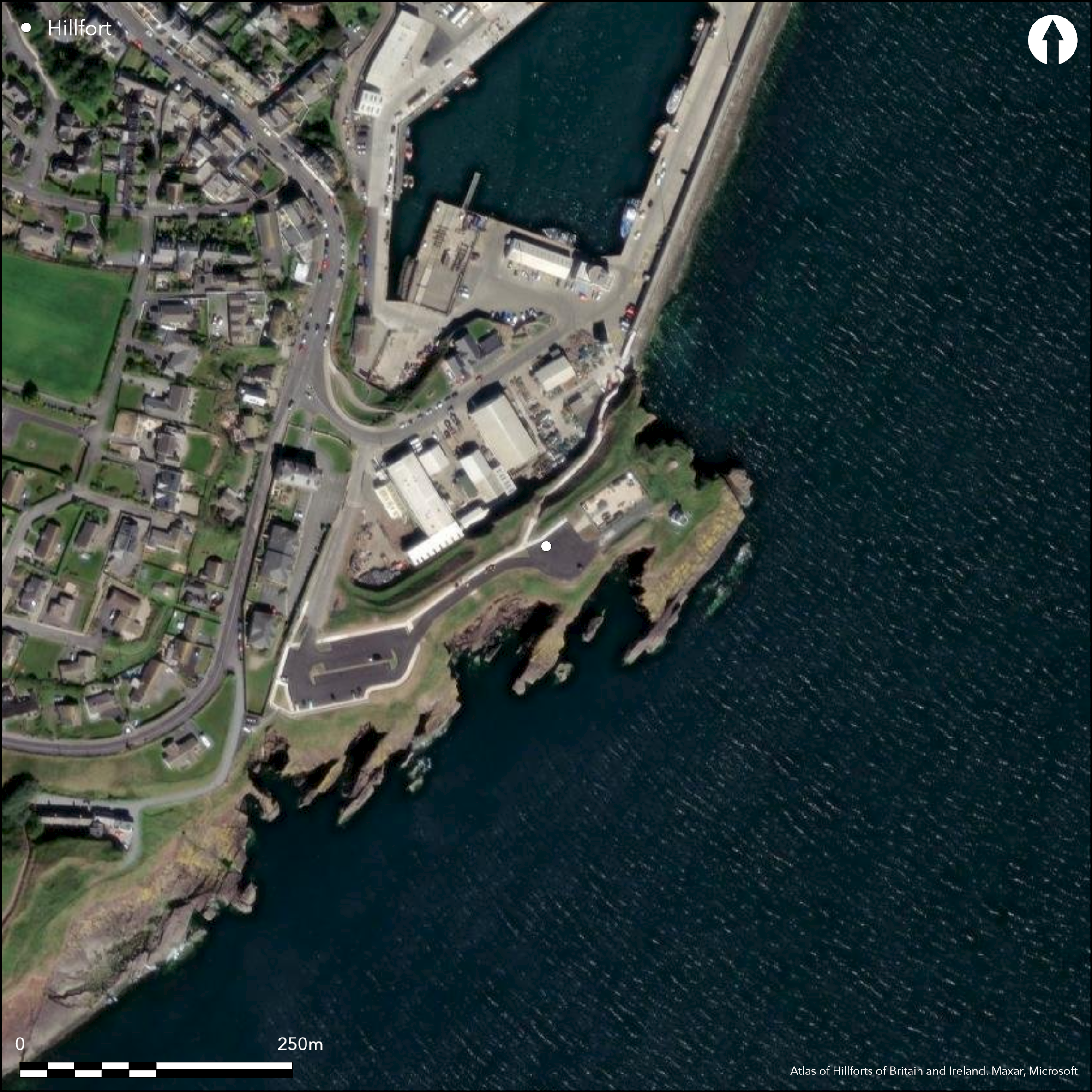
The headland, known locally as the ÇBlack Knob' can be described as a coastal promontory measuring 130m E-W by 60m N-S, projecting E into Waterford Harbour at an altitude of 8m OD. Named as 'Shandoan' (old fort) on the first edition 6-inch OS map (1840). Defences described by Westropp as a flat-topped earthen bank measuring 7m wide at the base and 3.5m at the top. It rose 3.6m above the external ditch. The latter measured 4.5m in width by 1.2m in depth and there was a possible counterscarp bank (1914-16, 212-14). The entrance to the interior was a simple gap (Wth 6m) located towards the centre of the enclosing elements which had an overall length of 60m. At the E end of the headland, a circular hut-site (int. diam. c. 3m) was recorded by Westropp along with a low enclosure (diam. c. 48m) and a possible embankment. The enclosing elements have since been levelled and the topsoil removed in the 1970's for commercial development (Moore 1999). The site was archaeologically tested in April 2001 in advance of further development and the results of this merited further excavation. The results of the excavation indicated that the site was totally disturbed and that the modern surface was created in parts over previously disturbed ground. No material of archaeological origin was uncovered (Cleary 2003, 388).
Citizen Science: ✗
Reliability of Data: Confirmed
Reliability of Interpretation: Confirmed
X: -778237 Y: 6826559 (EPSG: 3857)
Longitude: -6.99101778901618 Latitude: 52.145953584802704 (EPSG:4326)
Country: Republic of Ireland
Current County or Unitary Authority: Waterford
Historic County: Waterford
Current Parish/Community/Council/Townland: Dunmore
The enclosing elements have been levelled and the topsoil removed in the 1970s for commercial development (Moore 1999), and much of the interior built over or tarmacked.
| Extant | ✗ |
| Cropmark | ✗ |
| Likely Destroyed | ✓ |
Land redeveloped in 1970s for commercial premises and housing.
| Woodland | ✗ |
| Commercial Forestry Plantation | ✗ |
| Parkland | ✗ |
| Pasture (Grazing) | ✗ |
| Arable | ✗ |
| Scrub/Bracken | ✗ |
| Bare Outcrop | ✗ |
| Heather/Moorland | ✗ |
| Heath | ✗ |
| Built-up | ✓ |
| Coastal Grassland | ✗ |
| Other | ✓ |
Coastal promontory, now occupied by commercial premises and car park, projecting E into Waterford Harbour at an altitude of 8m OD. Defences described by Westropp as a flat-topped earthen bank and external ditch.
| Contour Fort | ✗ |
| Partial Contour Fort | ✗ |
| Promontory Fort | ✓ |
| Hillslope Fort | ✗ |
| Level Terrain Fort | ✗ |
| Marsh Fort | ✗ |
| Multiple Enclosure Fort | ✗ |
| Hilltop | ✗ |
| Coastal Promontory | ✓ |
| Inland Promontory | ✗ |
| Valley Bottom | ✗ |
| Knoll/Hillock/Outcrop | ✗ |
| Ridge | ✗ |
| Cliff/Plateau-edge/Scarp | ✗ |
| Hillslope | ✗ |
| Lowland | ✗ |
| Spur | ✗ |
Dominant Topographic Feature: E-facing promontory
| North | ✗ |
| Northeast | ✗ |
| East | ✓ |
| Southeast | ✗ |
| South | ✗ |
| Southwest | ✗ |
| West | ✗ |
| Northwest | ✗ |
| Level | ✗ |
Altitude: 8.0m
N/A
There is no dating available for the site
Reliability: D - None
| Pre 1200BC | ✗ |
| 1200BC - 800BC | ✗ |
| 800BC - 400BC | ✗ |
| 400BC - AD50 | ✗ |
| AD50 - AD400 | ✗ |
| AD400 - AD 800 | ✗ |
| Post AD800 | ✗ |
| Unknown | ✓ |
| Pre Hillfort: | None |
| Post Hillfort: | Land redeveloped in 1970s for commercial premises and housing. |
Named as 'Shandoan' (old fort) on the first edition six-inch OS map (1840). Defences described in 1914 by Westropp, who noted a 'convex work fairly preserved to the south, having a fosse about 4 feet deep and 15 feet wide, with a slight outer fence and a bold inner mound' (1914-16, 214). He also notes that a Rev. G. H. Reade 'found a flint knife of very early type within the ambit' (ibid). Site visited and inspected in 1989 for the compilation of the Archaeological Inventory of County Waterford (Moore 1999, 66). No material of archaeological origin was uncovered during archaeological testing in 2001 (Cleary 2003).
| 1st Identified Map Depiction (1840): | OS 6-inch mapping |
| Earthwork Survey (1989): | Moore |
| Excavation (2001): | Rose Cleary (UCC Services Unit) |
| 1st Identified Written Reference (None): | Westropp |
At the E end of the headland, a circular hut-site (int. diam. c. 3m) was recorded by Westropp along with a low enclosure (diam. c. 48m) and a possible embankment.
None
| None | ✓ |
| Spring | ✗ |
| Stream | ✗ |
| Pool | ✗ |
| Flush | ✗ |
| Well | ✗ |
| Other | ✗ |
None
| No Known Features | ✗ |
| Round Stone Structures | ✗ |
| Rectangular Stone Structures | ✗ |
| Curvilinear Platforms | ✗ |
| Other Roundhouse Evidence | ✓ |
| Pits | ✗ |
| Quarry Hollows | ✗ |
| Other | ✓ |
None
| No Known Excavation | ✗ |
| Pits | ✗ |
| Postholes | ✗ |
| Roundhouses | ✗ |
| Rectangular Structures | ✗ |
| Roads/Tracks | ✗ |
| Quarry Hollows | ✗ |
| Other | ✗ |
| Nothing Found | ✓ |
None
| No Known Geophysics | ✓ |
| Pits | ✗ |
| Roundhouses | ✗ |
| Rectangular Structures | ✗ |
| Roads/Tracks | ✗ |
| Quarry Hollows | ✗ |
| Other | ✗ |
| Nothing Found | ✗ |
Westrropp notes that a Rev. G. H. Reade 'found a flint knife of very early type within the ambit' (1914-16, 214).
| No Known Finds | ✗ |
| Pottery | ✗ |
| Metal | ✗ |
| Metalworking | ✗ |
| Human Bones | ✗ |
| Animal Bones | ✗ |
| Lithics | ✓ |
| Environmental | ✗ |
| Other | ✗ |
NO APPARENT FEATURES
| APs Not Checked | ✗ |
| None | ✓ |
| Roundhouses | ✗ |
| Rectangular Structures | ✗ |
| Pits | ✗ |
| Postholes | ✗ |
| Roads/Tracks | ✗ |
| Other | ✗ |
The entrance to the interior was a simple gap (Wth 6m) located towards the centre of the enclosing elements on the SW. It cannot be confirmed whether this is an original entrance to the site.
| 1: | None |
| 2: | None |
Guard Chambers: ✗
Chevaux de Frise: ✗
| 1. Simple Gap (South west): | No longer visible |
Defences described by Westropp as a flat-topped earthen bank (Wth at base c. 7m; int. H 1.8m; ext. H 3.6m; Wth at top 2-3.5m). The bank had an external ditch measuring 4.5m in width by 1.2m in depth and a possible counterscarp bank (1914-16, 212-14).
| Area 1: | 1.31ha. |
| Total: | 1.31ha. |
Total Footprint Area: 1.74ha.
None
| ✗ | None |
| ✗ | None |
| NE Quadrant: | 0 |
| SE Quadrant: | 0 |
| SW Quadrant: | 1 |
| NW Quadrant: | 0 |
| Total: | 1 |
| Partial Univallate | ✓ |
| Univallate | ✗ |
| Partial Bivallate | ✗ |
| Bivallate | ✗ |
| Partial Multivallate | ✗ |
| Multivallate | ✗ |
| Unknown | ✗ |
| Partial Univallate | ✗ |
| Univallate | ✗ |
| Partial Bivallate | ✗ |
| Bivallate | ✗ |
| Partial Multivallate | ✗ |
| Multivallate | ✗ |
Flat-topped earthen bank with an overall length of 60m. Levelled in the 1970s.
| None | ✗ |
| Earthen Bank | ✓ |
| Stone Wall | ✗ |
| Rubble | ✗ |
| Wall-walk | ✗ |
| Evidence of Timber | ✗ |
| Vitrification | ✗ |
| Other Burning | ✗ |
| Palisade | ✗ |
| Counter Scarp Bank | ✓ |
| Berm | ✗ |
| Unfinished | ✗ |
| Other | ✗ |
None
| None | ✗ |
| Earthen Bank | ✗ |
| Stone Wall | ✗ |
| Murus Duplex | ✗ |
| Timber-framed | ✗ |
| Timber-laced | ✗ |
| Vitrification | ✗ |
| Other Burning | ✗ |
| Palisade | ✗ |
| Counter Scarp Bank | ✗ |
| Berm | ✗ |
| Unfinished | ✗ |
| No Known Excavation | ✓ |
| Other | ✗ |
| ✗ | None |
| ✓ | The bank had an external ditch measuring 4.5m in width by 1.2m in depth and a possible counterscarp bank (1914-16, 212-14). |
Number of Ditches: 1
| ✗ | None |
Cleary, R.M 2003. Promontory Fort. In I Bennett (ed.) Excavations 2001, 388. Wordwell, Bray.
Moore, M. 1999. Archaeological inventory of County Waterford, 64-8. The stationary Office, Dublin.
Westropp, T.J. 1914-16 Fortified headlands and castles on the south coast of Munster: Part II, from Ardmore to Dunmore, Co. Waterford. Proceedings of the Royal Irish Academy 32C, 188-227
Atlas of Hillforts:
Wikidata:
This work is licensed under CC BY-SA 4.0![]()
![]()
![]() and should be cited as:
and should be cited as:
Lock, Gary and Ralston, Ian. 2024. Atlas of Hillforts of Britain and Ireland. Available at: https://hillforts.arch.ox.ac.uk
Document Version 1.1