Satellite Imagery
Satellite Imagery
HER: Archaeological Survey of Ireland SMR Database OF010-017 (None)
NMR: OF 010 (None)
SM: None
NGR: None
X: 650148 Y: 732239 (IRENET95)
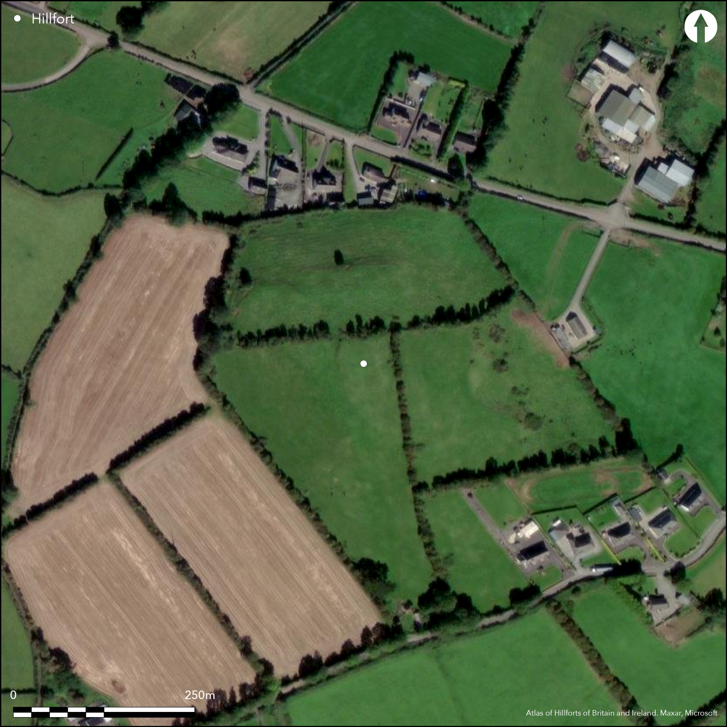
Sub-rectangular contour fort with a total site footprint of approximately 0.4ha positioned at summit of domed hilltop at the E edge of an isolated hill ridge. Univallate for the entire circuit with no obvious entrance features recorded. No evidence for any internal features on the surface. Rampart has been heavily affected by ploughing and is visible as a low scarp at the E, S and W. Originally the enclosing elements had an external ditch (O'Brien and Sweetman, 1997). First map depiction in first edition Ordnance Survey mapping. More detailed earthwork survey in second edition Ordnance Survey mapping. Site survey by O'Brien and Sweetman in 1997.
Citizen Science: ✗
Reliability of Data: Confirmed
Reliability of Interpretation: Unconfirmed
X: -806734 Y: 7045767 (EPSG: 3857)
Longitude: -7.247017873070862 Latitude: 53.338009570860436 (EPSG:4326)
Country: Republic of Ireland
Current County or Unitary Authority: Offaly
Historic County: Offaly
Current Parish/Community/Council/Townland: Togher
None
| Extant | ✗ |
| Cropmark | ✗ |
| Likely Destroyed | ✓ |
None
| Woodland | ✗ |
| Commercial Forestry Plantation | ✗ |
| Parkland | ✗ |
| Pasture (Grazing) | ✓ |
| Arable | ✗ |
| Scrub/Bracken | ✗ |
| Bare Outcrop | ✗ |
| Heather/Moorland | ✗ |
| Heath | ✗ |
| Built-up | ✗ |
| Coastal Grassland | ✗ |
| Other | ✗ |
Contour fort situated at summit of domed hilltop. This hilltop is positioned at the E edge of an isolated hill ridge. Situated 2km SE of a possible hillfort on Croghan Hill.
| Contour Fort | ✓ |
| Partial Contour Fort | ✗ |
| Promontory Fort | ✗ |
| Hillslope Fort | ✗ |
| Level Terrain Fort | ✗ |
| Marsh Fort | ✗ |
| Multiple Enclosure Fort | ✗ |
| Hilltop | ✓ |
| Coastal Promontory | ✗ |
| Inland Promontory | ✗ |
| Valley Bottom | ✗ |
| Knoll/Hillock/Outcrop | ✗ |
| Ridge | ✗ |
| Cliff/Plateau-edge/Scarp | ✗ |
| Hillslope | ✗ |
| Lowland | ✗ |
| Spur | ✗ |
Dominant Topographic Feature: Hilltop.
| North | ✗ |
| Northeast | ✗ |
| East | ✗ |
| Southeast | ✗ |
| South | ✗ |
| Southwest | ✗ |
| West | ✗ |
| Northwest | ✗ |
| Level | ✓ |
Altitude: 127.0m
N/A
None.
Reliability: D - None
| Pre 1200BC | ✗ |
| 1200BC - 800BC | ✗ |
| 800BC - 400BC | ✗ |
| 400BC - AD50 | ✗ |
| AD50 - AD400 | ✗ |
| AD400 - AD 800 | ✗ |
| Post AD800 | ✗ |
| Unknown | ✓ |
| Pre Hillfort: | None |
| Post Hillfort: | None |
First map depiction in first edition Ordnance Survey mapping. More detailed earthwork survey in second edition Ordnance Survey mapping. Site survey by O'Brien and Sweetman in 1997.
| None (1842): | First edition Ordnance Survey 6 inch mapping. |
| None (1906): | Second edition 25 inch Ordnance Survey mapping. |
| None (1997): | Site survey by O'Brien and Sweetman |
No evidence for any internal features on the surface.
None
| None | ✓ |
| Spring | ✗ |
| Stream | ✗ |
| Pool | ✗ |
| Flush | ✗ |
| Well | ✗ |
| Other | ✗ |
None
| No Known Features | ✓ |
| Round Stone Structures | ✗ |
| Rectangular Stone Structures | ✗ |
| Curvilinear Platforms | ✗ |
| Other Roundhouse Evidence | ✗ |
| Pits | ✗ |
| Quarry Hollows | ✗ |
| Other | ✗ |
None
| No Known Excavation | ✓ |
| Pits | ✗ |
| Postholes | ✗ |
| Roundhouses | ✗ |
| Rectangular Structures | ✗ |
| Roads/Tracks | ✗ |
| Quarry Hollows | ✗ |
| Other | ✗ |
| Nothing Found | ✗ |
None
| No Known Geophysics | ✓ |
| Pits | ✗ |
| Roundhouses | ✗ |
| Rectangular Structures | ✗ |
| Roads/Tracks | ✗ |
| Quarry Hollows | ✗ |
| Other | ✗ |
| Nothing Found | ✗ |
None
| No Known Finds | ✓ |
| Pottery | ✗ |
| Metal | ✗ |
| Metalworking | ✗ |
| Human Bones | ✗ |
| Animal Bones | ✗ |
| Lithics | ✗ |
| Environmental | ✗ |
| Other | ✗ |
NO APPARENT FEATURES
| APs Not Checked | ✗ |
| None | ✓ |
| Roundhouses | ✗ |
| Rectangular Structures | ✗ |
| Pits | ✗ |
| Postholes | ✗ |
| Roads/Tracks | ✗ |
| Other | ✗ |
There are no obvious entrance features.
| 0: | None |
| 2: | None |
Guard Chambers: ✗
Chevaux de Frise: ✗
Sub-rectangular area defined by a heavily denuded bank which survives as a scarp at the E, S and W (O'Brien and Sweetman, 1997). Originally the bank had an external ditch. The N section of the enclosing elements were levelled prior to the completion of the first edition Ordnance Survey maps.
| Area 1: | 0.2ha. |
| Total: | 0.2ha. |
Total Footprint Area: 0.38ha.
None
| ✗ | None |
| ✓ | None |
| NE Quadrant: | 1 |
| SE Quadrant: | 1 |
| SW Quadrant: | 1 |
| NW Quadrant: | 1 |
| Total: | 1 |
| Partial Univallate | ✗ |
| Univallate | ✓ |
| Partial Bivallate | ✗ |
| Bivallate | ✗ |
| Partial Multivallate | ✗ |
| Multivallate | ✗ |
| Unknown | ✗ |
| Partial Univallate | ✗ |
| Univallate | ✗ |
| Partial Bivallate | ✗ |
| Bivallate | ✗ |
| Partial Multivallate | ✗ |
| Multivallate | ✗ |
None
| None | ✗ |
| Earthen Bank | ✓ |
| Stone Wall | ✗ |
| Rubble | ✗ |
| Wall-walk | ✗ |
| Evidence of Timber | ✗ |
| Vitrification | ✗ |
| Other Burning | ✗ |
| Palisade | ✗ |
| Counter Scarp Bank | ✗ |
| Berm | ✗ |
| Unfinished | ✗ |
| Other | ✗ |
None
| None | ✗ |
| Earthen Bank | ✗ |
| Stone Wall | ✗ |
| Murus Duplex | ✗ |
| Timber-framed | ✗ |
| Timber-laced | ✗ |
| Vitrification | ✗ |
| Other Burning | ✗ |
| Palisade | ✗ |
| Counter Scarp Bank | ✗ |
| Berm | ✗ |
| Unfinished | ✗ |
| No Known Excavation | ✓ |
| Other | ✗ |
| ✗ | None |
| ✓ | None |
Number of Ditches: 1
| ✗ | None. |
O'Brien, C and Sweetman, D. 1997. Archaeological inventory of County Offaly. The Stationary Office, Dublin.
Atlas of Hillforts:
Wikidata:
This work is licensed under CC BY-SA 4.0![]()
![]()
![]() and should be cited as:
and should be cited as:
Lock, Gary and Ralston, Ian. 2024. Atlas of Hillforts of Britain and Ireland. Available at: https://hillforts.arch.ox.ac.uk
Document Version 1.1