Satellite Imagery
Satellite Imagery
HER: Archaeological Survey of Ireland SMR Database WX012-012 (None)
NMR: WX 012 (None)
SM: None
NGR: None
X: 720375 Y: 653240 (IRENET95)
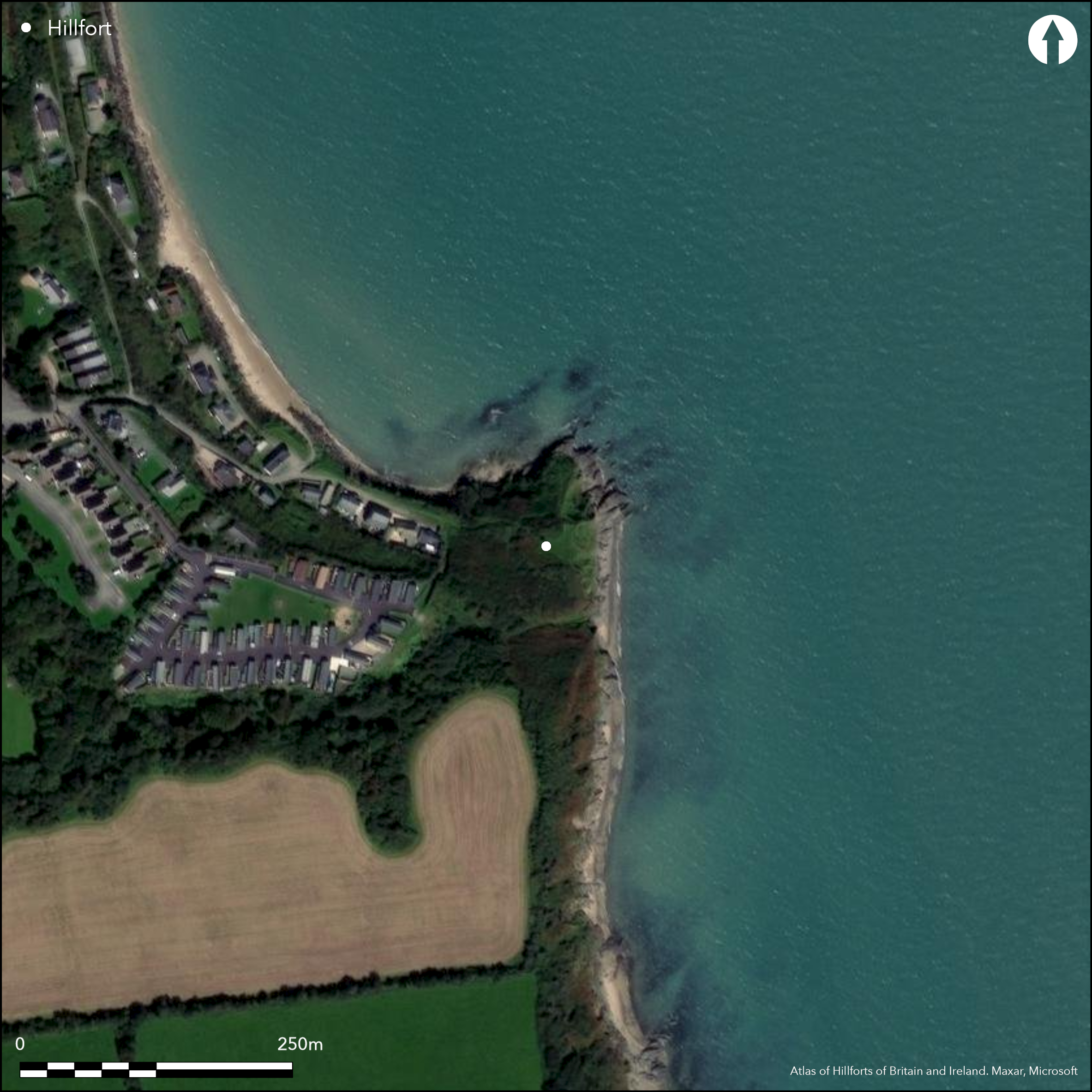
This possible coastal promontory fort is situated at a height of 7m OD on Polshone Head, c. 4km S of Courtown in Co. Wexford. The sea is situated immediately adjacent on the NW and E sides, while a ravine lies on the S side. Depicted as 'Pollshone Moat' on the first edition six-inch OS map, the defences comprise two enclosures. The inner is sub-circular or D-shaped (dims. 32m E-W; 29m N-S); its perimeter is defined by scarps (H 1.6-2m) at the N and S, and though destroyed by sea erosion at the E, a curving bank with an external ditch and counterscarp bank survive on the W. The bank is 5m in width and 0.4m in height while the external ditch is 8m wide at the top and 1.2m deep and the counterscarp bank is 4m wide and 0.3m high. The perimeter of the outer enclosure lies eccentrically to the inner, comprising a ditch (Wth of top 6m; D 2m) cutting across the neck of the promontory, the only part not of its interior not occupied by the inner enclosure being a triangular area on the W (dims. 28m E-W; 23m N-S at E). It is suggested that the inner enclosure may have been a rath or ringfort imposed on earlier defences (Moore 1996, 26).
Citizen Science: ✗
Reliability of Data: Confirmed
Reliability of Interpretation: Unconfirmed
X: -692666 Y: 6912473 (EPSG: 3857)
Longitude: -6.222321222132764 Latitude: 52.61704513519469 (EPSG:4326)
Country: Republic of Ireland
Current County or Unitary Authority: Wexford
Historic County: Wexford
Current Parish/Community/Council/Townland: Glen (Richards)
None
| Extant | ✓ |
| Cropmark | ✗ |
| Likely Destroyed | ✗ |
None
| Woodland | ✗ |
| Commercial Forestry Plantation | ✗ |
| Parkland | ✗ |
| Pasture (Grazing) | ✗ |
| Arable | ✗ |
| Scrub/Bracken | ✓ |
| Bare Outcrop | ✗ |
| Heather/Moorland | ✗ |
| Heath | ✗ |
| Built-up | ✗ |
| Coastal Grassland | ✗ |
| Other | ✗ |
This possible coastal promontory fort is situated at Polshone Head, with the sea on the NW and E sides while a ravine is on the S side. Depicted as 'Pollshone Moat' on the first edition six-inch OS map, the oval, grass-covered area is defended by two oval sets of defences at an altitude of 7m OD.
| Contour Fort | ✗ |
| Partial Contour Fort | ✗ |
| Promontory Fort | ✓ |
| Hillslope Fort | ✗ |
| Level Terrain Fort | ✗ |
| Marsh Fort | ✗ |
| Multiple Enclosure Fort | ✗ |
| Hilltop | ✗ |
| Coastal Promontory | ✓ |
| Inland Promontory | ✗ |
| Valley Bottom | ✗ |
| Knoll/Hillock/Outcrop | ✗ |
| Ridge | ✗ |
| Cliff/Plateau-edge/Scarp | ✗ |
| Hillslope | ✗ |
| Lowland | ✗ |
| Spur | ✗ |
Dominant Topographic Feature: N-E facing promontory
| North | ✗ |
| Northeast | ✓ |
| East | ✗ |
| Southeast | ✗ |
| South | ✗ |
| Southwest | ✗ |
| West | ✗ |
| Northwest | ✗ |
| Level | ✗ |
Altitude: 7.0m
N/A
site not dated
Reliability: D - None
| Pre 1200BC | ✗ |
| 1200BC - 800BC | ✗ |
| 800BC - 400BC | ✗ |
| 400BC - AD50 | ✗ |
| AD50 - AD400 | ✗ |
| AD400 - AD 800 | ✗ |
| Post AD800 | ✗ |
| Unknown | ✓ |
| Pre Hillfort: | None |
| Post Hillfort: | Possible ringfort built within an earlier defence (Moore 1996, 26) |
Depicted as 'Pollshone Moat' on the first edition six-inch OS map (1840s). Site investigated for the compilation of the Wexford Archaeological Inventory in 1987 (Moore 1996).
| 1st Identified Map Depiction (1840): | First edition six-inch mapping |
| Earthwork Survey (1987): | Moore |
There are no recorded internal features within the enclosed area
None
| None | ✓ |
| Spring | ✗ |
| Stream | ✗ |
| Pool | ✗ |
| Flush | ✗ |
| Well | ✗ |
| Other | ✗ |
None
| No Known Features | ✓ |
| Round Stone Structures | ✗ |
| Rectangular Stone Structures | ✗ |
| Curvilinear Platforms | ✗ |
| Other Roundhouse Evidence | ✗ |
| Pits | ✗ |
| Quarry Hollows | ✗ |
| Other | ✗ |
None
| No Known Excavation | ✓ |
| Pits | ✗ |
| Postholes | ✗ |
| Roundhouses | ✗ |
| Rectangular Structures | ✗ |
| Roads/Tracks | ✗ |
| Quarry Hollows | ✗ |
| Other | ✗ |
| Nothing Found | ✗ |
None
| No Known Geophysics | ✓ |
| Pits | ✗ |
| Roundhouses | ✗ |
| Rectangular Structures | ✗ |
| Roads/Tracks | ✗ |
| Quarry Hollows | ✗ |
| Other | ✗ |
| Nothing Found | ✗ |
None
| No Known Finds | ✓ |
| Pottery | ✗ |
| Metal | ✗ |
| Metalworking | ✗ |
| Human Bones | ✗ |
| Animal Bones | ✗ |
| Lithics | ✗ |
| Environmental | ✗ |
| Other | ✗ |
NO APPARENT FEATURES
| APs Not Checked | ✗ |
| None | ✓ |
| Roundhouses | ✗ |
| Rectangular Structures | ✗ |
| Pits | ✗ |
| Postholes | ✗ |
| Roads/Tracks | ✗ |
| Other | ✗ |
There are no recorded entrances
| 0: | None |
| 2: | None |
Guard Chambers: ✗
Chevaux de Frise: ✗
The defences comprise two enclosures. The inner is sub-circular or D-shaped (dims. 32m E-W; 29m N-S); its perimeter is defined by scarps (H 1.6-2m) at the N and S, and though destroyed by sea erosion at the E, a curving bank with an external ditch and counterscarp bank survive on the W. The bank is 5m in width and 0.4m in height while the external ditch is 8m wide at the top and 1.2m deep and the counterscarp bank is 4m wide and 0.3m high. The perimeter of the outer enclosure lies eccentrically to the inner, comprising a ditch (Wth of top 6m; D 2m) cutting across the neck of the promontory
| Area 1: | 0.05ha. |
| Total: | 0.05ha. |
Total Footprint Area: 0.12ha.
None
| ✓ | It is suggested that the inner enclosure may have been a rath or ringfort imposed on earlier defences (Moore 1996, 26). |
| ✓ | Probably representing two periods of construction |
| NE Quadrant: | 1 |
| SE Quadrant: | 1 |
| SW Quadrant: | 2 |
| NW Quadrant: | 2 |
| Total: | 2 |
| Partial Univallate | ✓ |
| Univallate | ✗ |
| Partial Bivallate | ✓ |
| Bivallate | ✗ |
| Partial Multivallate | ✗ |
| Multivallate | ✗ |
| Unknown | ✗ |
| Partial Univallate | ✗ |
| Univallate | ✗ |
| Partial Bivallate | ✗ |
| Bivallate | ✗ |
| Partial Multivallate | ✗ |
| Multivallate | ✗ |
None
| None | ✗ |
| Earthen Bank | ✓ |
| Stone Wall | ✗ |
| Rubble | ✗ |
| Wall-walk | ✗ |
| Evidence of Timber | ✗ |
| Vitrification | ✗ |
| Other Burning | ✗ |
| Palisade | ✗ |
| Counter Scarp Bank | ✓ |
| Berm | ✗ |
| Unfinished | ✗ |
| Other | ✗ |
None
| None | ✗ |
| Earthen Bank | ✗ |
| Stone Wall | ✗ |
| Murus Duplex | ✗ |
| Timber-framed | ✗ |
| Timber-laced | ✗ |
| Vitrification | ✗ |
| Other Burning | ✗ |
| Palisade | ✗ |
| Counter Scarp Bank | ✗ |
| Berm | ✗ |
| Unfinished | ✗ |
| No Known Excavation | ✓ |
| Other | ✗ |
| ✗ | None |
| ✓ | None |
Number of Ditches: 2
| ✗ | None |
Moore, M. 1996. Archaeological inventory of County Wexford, 26. The stationary Office, Dublin
Atlas of Hillforts:
Wikidata:
This work is licensed under CC BY-SA 4.0![]()
![]()
![]() and should be cited as:
and should be cited as:
Lock, Gary and Ralston, Ian. 2024. Atlas of Hillforts of Britain and Ireland. Available at: https://hillforts.arch.ox.ac.uk
Document Version 1.1