LiDAR 1m DTM Hillshade
Satellite Imagery
LiDAR 1m DTM Hillshade
Satellite Imagery
Scroll left/right to view further images.
HER: Archaeological Survey of Ireland SMR Database ME019-038 (None)
NMR: ME 019 (None)
SM: None
NGR: None
X: 699495 Y: 772928 (IRENET95)
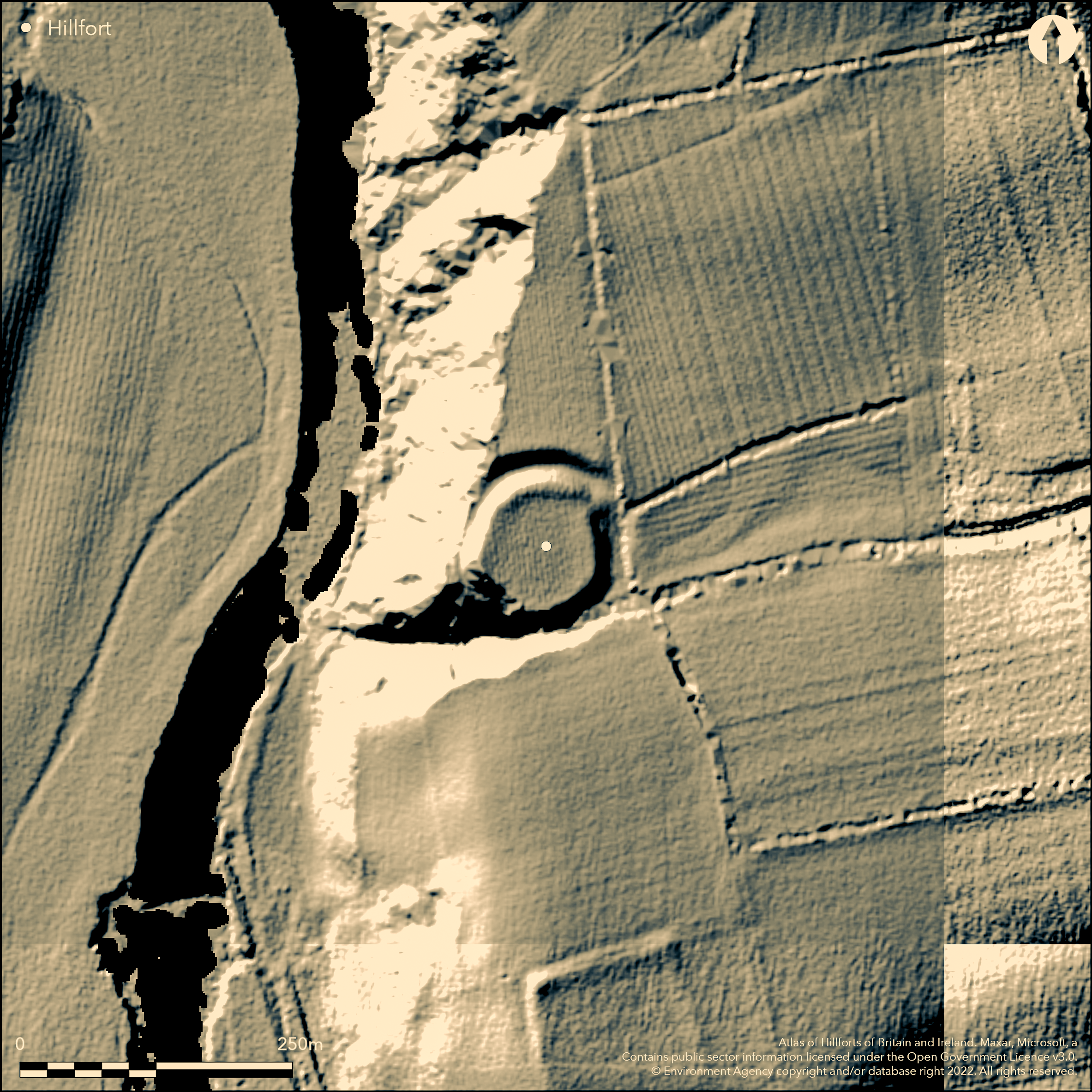
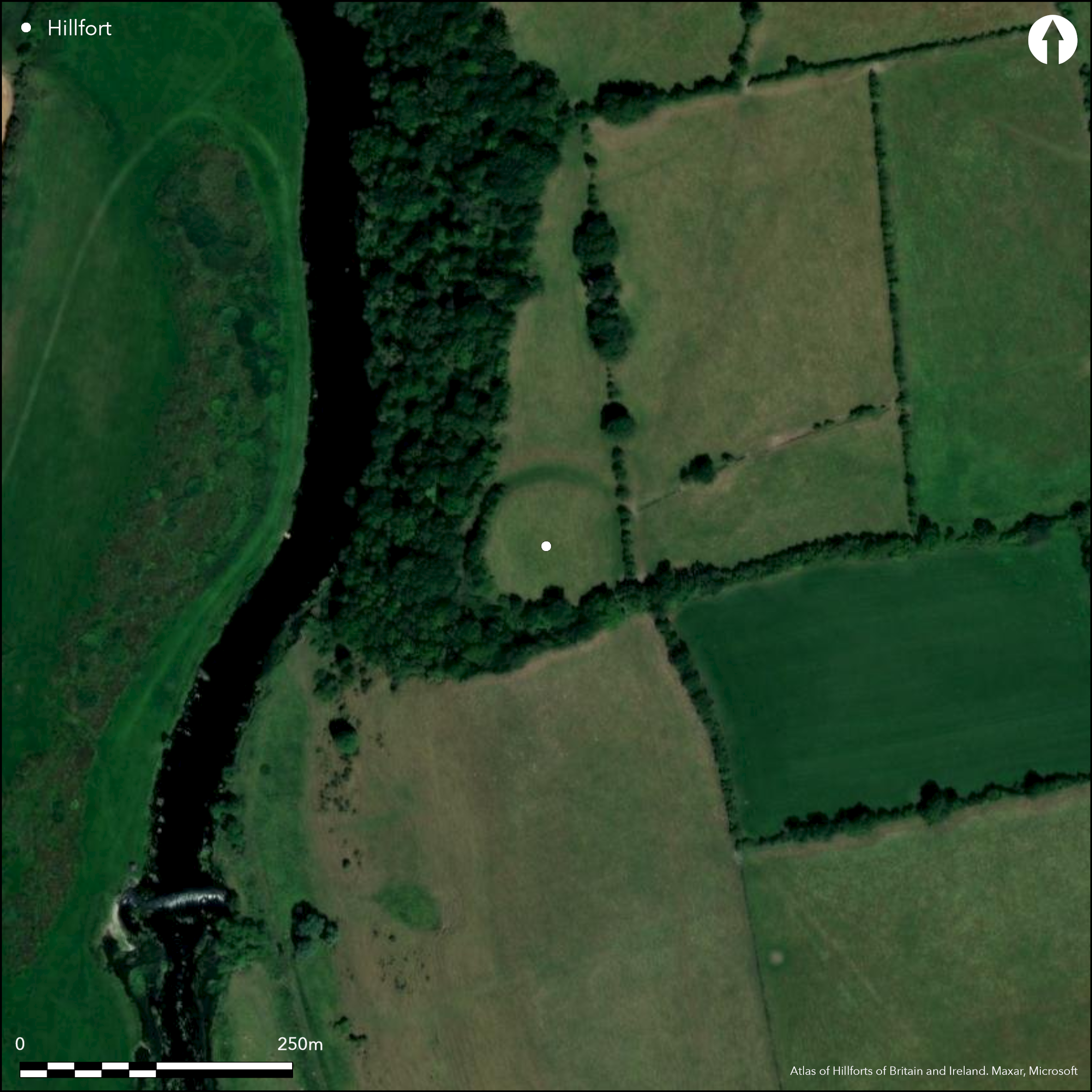
What may be a circular inland promontory fort with a total site footprint of approximately 1ha positioned at the edge of a steep slope formed by the Boyne River to the W. The remainder of the fort is defined by a bank, external ditch and counterscarp bank, though these are now apparent only in the N. Excellent views of the Boyne River valley from the interior. The fort is positioned near the famous Boyne Valley passage tombs of Newgrange, Knowth and Dowth and is overlooked by the former two. Univallate with a counterscarp bank on the N, the site has one recorded entrance. This comprises a simple break in the enclosing elements on the ENE. No evidence for any internal features on the surface. Interior under pasture and tree cover at SW and W. Ramparts survive well at N but have been partially truncated by a later field system at E and S. First map depiction in first edition Ordnance Survey mapping. More detailed earthwork survey in second edition Ordnance Survey maps. Survey by O'Kelly (1978). Site survey by Sweetman (1987). LiDAR survey by Davis et al. (2010).
Citizen Science: ✗
Reliability of Data: Confirmed
Reliability of Interpretation: Unconfirmed
X: -722837 Y: 7112898 (EPSG: 3857)
Longitude: -6.493357512228917 Latitude: 53.69656867591975 (EPSG:4326)
Country: Republic of Ireland; None
Current County or Unitary Authority: Meath
Historic County: Meath
Current Parish/Community/Council/Townland: Knowth
Partially truncated by later field systems.
| Extant | ✓ |
| Cropmark | ✗ |
| Likely Destroyed | ✓ |
None
| Woodland | ✗ |
| Commercial Forestry Plantation | ✗ |
| Parkland | ✗ |
| Pasture (Grazing) | ✓ |
| Arable | ✗ |
| Scrub/Bracken | ✓ |
| Bare Outcrop | ✗ |
| Heather/Moorland | ✗ |
| Heath | ✗ |
| Built-up | ✗ |
| Coastal Grassland | ✗ |
| Other | ✗ |
Inland promontory fort positioned at the edge of a steep slope formed by the Boyne River to the W. The remainder of the fort is defined by a bank, external ditch and counterscarp bank apparent only in the N. Excellent views of the Boyne River valley from the interior. The fort is positioned near the famous Boyne Valley passage tombs of Newgrange, Knowth and Dowth and is overlooked by the former two.
| Contour Fort | ✗ |
| Partial Contour Fort | ✗ |
| Promontory Fort | ✓ |
| Hillslope Fort | ✗ |
| Level Terrain Fort | ✗ |
| Marsh Fort | ✗ |
| Multiple Enclosure Fort | ✗ |
| Hilltop | ✗ |
| Coastal Promontory | ✗ |
| Inland Promontory | ✓ |
| Valley Bottom | ✗ |
| Knoll/Hillock/Outcrop | ✗ |
| Ridge | ✗ |
| Cliff/Plateau-edge/Scarp | ✗ |
| Hillslope | ✗ |
| Lowland | ✗ |
| Spur | ✗ |
Dominant Topographic Feature: Promontory.
| North | ✗ |
| Northeast | ✗ |
| East | ✗ |
| Southeast | ✗ |
| South | ✗ |
| Southwest | ✗ |
| West | ✗ |
| Northwest | ✗ |
| Level | ✓ |
Altitude: 42.0m
The S section of the enclosing elements form the townland boundary of Knowth and Newgrange.
Boundary Type: None
None, but possibly an early medieval ringfort.
Reliability: D - None
| Pre 1200BC | ✗ |
| 1200BC - 800BC | ✗ |
| 800BC - 400BC | ✗ |
| 400BC - AD50 | ✗ |
| AD50 - AD400 | ✗ |
| AD400 - AD 800 | ✗ |
| Post AD800 | ✗ |
| Unknown | ✓ |
| Pre Hillfort: | None |
| Post Hillfort: | None |
First map depiction in first edition Ordnance Survey mapping. More detailed earthwork survey in second edition Ordnance Survey maps. Survey by O'Kelly (1978). Site survey by Sweetman (1987). LiDAR survey by Davis et al. (2010).
| 1st Identified Map Depiction (1842): | First edition 6 inch Ordnance Survey mapping. |
| Earthwork Survey (1906): | Second edition Ordnance Survey 25 inch mapping. |
| Other (1978): | Site survey by O'Kelly. |
| Other (1987): | Site survey by Sweetman. |
| LiDAR Survey (2010): | LiDAR survey by Davis et al. |
No evidence for any internal features on the surface.
None
| None | ✓ |
| Spring | ✗ |
| Stream | ✗ |
| Pool | ✗ |
| Flush | ✗ |
| Well | ✗ |
| Other | ✗ |
None
| No Known Features | ✓ |
| Round Stone Structures | ✗ |
| Rectangular Stone Structures | ✗ |
| Curvilinear Platforms | ✗ |
| Other Roundhouse Evidence | ✗ |
| Pits | ✗ |
| Quarry Hollows | ✗ |
| Other | ✗ |
None
| No Known Excavation | ✓ |
| Pits | ✗ |
| Postholes | ✗ |
| Roundhouses | ✗ |
| Rectangular Structures | ✗ |
| Roads/Tracks | ✗ |
| Quarry Hollows | ✗ |
| Other | ✗ |
| Nothing Found | ✗ |
None
| No Known Geophysics | ✓ |
| Pits | ✗ |
| Roundhouses | ✗ |
| Rectangular Structures | ✗ |
| Roads/Tracks | ✗ |
| Quarry Hollows | ✗ |
| Other | ✗ |
| Nothing Found | ✗ |
None
| No Known Finds | ✓ |
| Pottery | ✗ |
| Metal | ✗ |
| Metalworking | ✗ |
| Human Bones | ✗ |
| Animal Bones | ✗ |
| Lithics | ✗ |
| Environmental | ✗ |
| Other | ✗ |
NO APPARENT FEATURES
| APs Not Checked | ✗ |
| None | ✓ |
| Roundhouses | ✗ |
| Rectangular Structures | ✗ |
| Pits | ✗ |
| Postholes | ✗ |
| Roads/Tracks | ✗ |
| Other | ✗ |
O'Kelly (1978, 62) recorded a simple entrance gap in the enclosing elements at the ENE which comprised a break through the bank and causeway over the ditch.
| 1: | None |
| 2: | None |
Guard Chambers: ✗
Chevaux de Frise: ✗
| 1. Simple Gap (East): | None |
Circular area defined by an internal bank and external ditch, with a external counterscarp at the N recorded in the second edition Ordnance Survey maps. The ditch and external scarp have been truncated by a later field boundary at the E, S and W. A steep slope at the W edge of the site is formed by the River Boyne.
| Area 1: | 0.36ha. |
| Total: | 0.36ha. |
Total Footprint Area: 0.96ha.
None
| ✗ | None |
| ✓ | Counterscarp apparent at N. |
| NE Quadrant: | 1 |
| SE Quadrant: | 1 |
| SW Quadrant: | 1 |
| NW Quadrant: | 1 |
| Total: | 1 |
| Partial Univallate | ✗ |
| Univallate | ✓ |
| Partial Bivallate | ✗ |
| Bivallate | ✗ |
| Partial Multivallate | ✗ |
| Multivallate | ✗ |
| Unknown | ✗ |
| Partial Univallate | ✗ |
| Univallate | ✗ |
| Partial Bivallate | ✗ |
| Bivallate | ✗ |
| Partial Multivallate | ✗ |
| Multivallate | ✗ |
None
| None | ✗ |
| Earthen Bank | ✓ |
| Stone Wall | ✗ |
| Rubble | ✗ |
| Wall-walk | ✗ |
| Evidence of Timber | ✗ |
| Vitrification | ✗ |
| Other Burning | ✗ |
| Palisade | ✗ |
| Counter Scarp Bank | ✓ |
| Berm | ✗ |
| Unfinished | ✗ |
| Other | ✗ |
None
| None | ✓ |
| Earthen Bank | ✗ |
| Stone Wall | ✗ |
| Murus Duplex | ✗ |
| Timber-framed | ✗ |
| Timber-laced | ✗ |
| Vitrification | ✗ |
| Other Burning | ✗ |
| Palisade | ✗ |
| Counter Scarp Bank | ✗ |
| Berm | ✗ |
| Unfinished | ✗ |
| No Known Excavation | ✗ |
| Other | ✗ |
| ✗ | None |
| ✓ | External ditch. |
Number of Ditches: 1
| ✗ | None. |
Davis, S., Megarry, W., Brady, C., Lewis, H., Cummins, T., Guinan, L., Turner, J., Gallagher, C., Brown, T. and Meehan, R. 2010. Boyne Valley Landscapes Project: Phase III Summary Report. Irish National Strategic Archaeological Research (INSTAR) Programme 2010.
O'Kelly, M. 1978. Illustrated Guide to Newgrange and the other Boyne Monuments (3rd ed). Cork.
Sweetman, D. 1987. Archaeological Inventory of County Meath. The Stationary Office, Dublin.
Atlas of Hillforts:
Wikidata:
This work is licensed under CC BY-SA 4.0![]()
![]()
![]() and should be cited as:
and should be cited as:
Lock, Gary and Ralston, Ian. 2024. Atlas of Hillforts of Britain and Ireland. Available at: https://hillforts.arch.ox.ac.uk
Document Version 1.1