Satellite Imagery
Satellite Imagery
HER: Archaeological Survey of Ireland SMR Database SL020-166001 (None)
NMR: SL 020 (None)
SM: None
NGR: None
X: 567228 Y: 828760 (IRENET95)
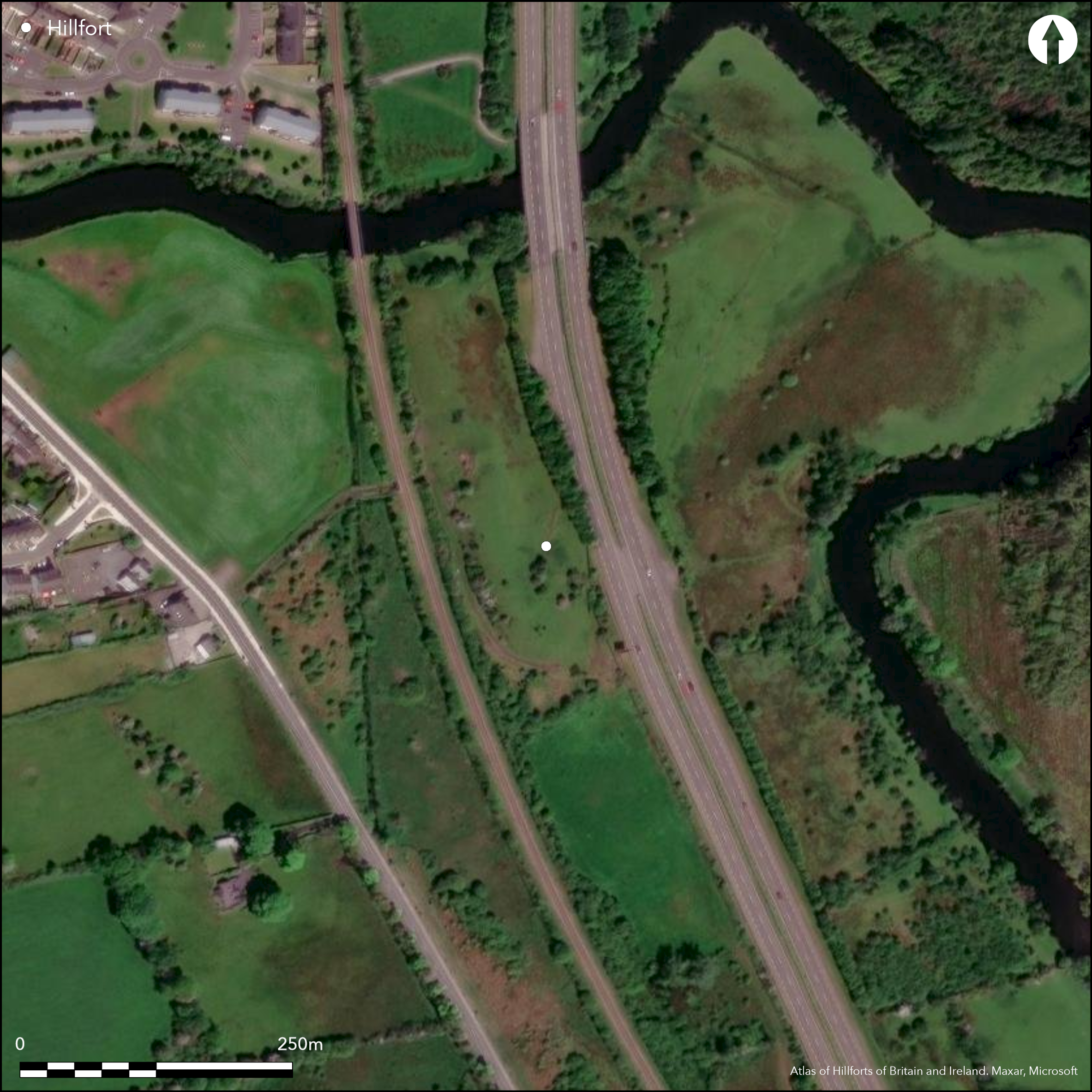
Near the town of Ballysadare, a sub-circular inland promontory fort with a total site foot print of approximately 0.3ha is located in a commanding position at W side of bend in Ballysadare River. Mount (2003, 105) suggests that the fort is well sited to control river traffic from Ballysadare Bay along the Ballysadare River and to guard a possible river crossing between the Barony of Tirerrill to the E and Leyny to the W. The fort is enclosed at the N, E and S by the river and by the expanse of a silted marshy lake at the W (Mount 1994, 22). The fort was built at the S potion of an elongated limestone ridge at the center of this area (Mount 1994 22 - 23). A bank and external ditch was constructed across the NE neck of this ridge. Univallate at the S, Channing (1997) notes a series of three ditches at the N of the site and suggests these may be related to the enclosing elements of the promontory fort. Simple entrance break at the S excavated by Mount (1994, 22). A number of features within the interior likely date to several chronological periods and attest to the longevity of occupation at the site. These include two cairns, a possible Early Medieval cemetery, a rectangular enclosure, pits, postholes, four hut structures a large quantity of butchered animal bones, iron tools and nails, iron smelting slag and furnace bottoms and four hut sites (Mount 2003, 113). Site is now under protection order. Ramparts heavily denuded. Interior under pasture and patches of scrub growth. First map depiction in first edition Ordnance Survey mapping. More detailed earthwork survey in second edition Ordnance Survey maps. Excavations by Mount prior to the development of the Collooney/Ballysadare by-pass in 1994. Excavation by Channing at N of promontory fort. Site survey by Egan et al. in 2005. Kelly (2009) has recently re-interpreted the site as a Viking Age longphort.
Citizen Science: ✗
Reliability of Data: Confirmed
Reliability of Interpretation: Unconfirmed
X: -946476 Y: 7209401 (EPSG: 3857)
Longitude: -8.502341603930441 Latitude: 54.20670284075974 (EPSG:4326)
Country: Republic of Ireland
Current County or Unitary Authority: Sligo
Historic County: Sligo
Current Parish/Community/Council/Townland: Knoxspark
None
| Extant | ✓ |
| Cropmark | ✗ |
| Likely Destroyed | ✗ |
None
| Woodland | ✗ |
| Commercial Forestry Plantation | ✗ |
| Parkland | ✗ |
| Pasture (Grazing) | ✓ |
| Arable | ✗ |
| Scrub/Bracken | ✓ |
| Bare Outcrop | ✗ |
| Heather/Moorland | ✗ |
| Heath | ✗ |
| Built-up | ✗ |
| Coastal Grassland | ✗ |
| Other | ✗ |
Inland promontory fort positioned at W side of bend in Ballysadare River. The fort is enclosed at the N, E and S by the river and by the expanse of a silted marshy lake at the W (Mount 1994, 22). The fort was built at the S end of an elongated limestone ridge at the centre of this area (Mount 1994 22 - 23). A stone-faced bank and external ditch was constructed across the neck of this ridge on the NE, creating what Mount (1994) suggests is an inland promontory fort. Mount (2003, 105) suggests that the fort is well sited to control river traffic from Ballysadare Bay along the Ballysadare River and to guard a possible river crossing between the Barony of Tirerrill to the E and Leyny to the W.
| Contour Fort | ✗ |
| Partial Contour Fort | ✗ |
| Promontory Fort | ✓ |
| Hillslope Fort | ✗ |
| Level Terrain Fort | ✗ |
| Marsh Fort | ✗ |
| Multiple Enclosure Fort | ✗ |
| Hilltop | ✗ |
| Coastal Promontory | ✗ |
| Inland Promontory | ✓ |
| Valley Bottom | ✗ |
| Knoll/Hillock/Outcrop | ✗ |
| Ridge | ✗ |
| Cliff/Plateau-edge/Scarp | ✗ |
| Hillslope | ✗ |
| Lowland | ✗ |
| Spur | ✗ |
Dominant Topographic Feature: Ridge.
| North | ✗ |
| Northeast | ✗ |
| East | ✗ |
| Southeast | ✗ |
| South | ✗ |
| Southwest | ✗ |
| West | ✗ |
| Northwest | ✗ |
| Level | ✓ |
Altitude: 30.0m
N/A
An animal bone found in the ditch produced a radiocarbon date of 1260+/-40 BP (GrA-2452; 660 to 880 cal AD) (Mount 2003, 106). Despite this, Mount (1994, 1995, 2003) describes the promontory fort as 'Iron Age'. The cemetery may have been Early Medieval. Kelly (2009) has argued that the promontory fort is actually part of a later Viking Age Longphort.
Reliability: B - Medium
| Pre 1200BC | ✗ |
| 1200BC - 800BC | ✗ |
| 800BC - 400BC | ✗ |
| 400BC - AD50 | ✗ |
| AD50 - AD400 | ✗ |
| AD400 - AD 800 | ✓ |
| Post AD800 | ✗ |
| Unknown | ✗ |
| Pre Hillfort: | None |
| Post Hillfort: | None |
| C14: | None |
First map depiction in first edition Ordnance Survey mapping. More detailed earthwork survey in second edition Ordnance Survey maps. Excavations by Mount prior to the development of the Collooney/Ballysadare by-pass in 1994. Excavation by Channing at N of promontory fort. Site survey by Egan et al. in 2005.
| 1st Identified Map Depiction (1842): | First edition Ordnance Survey 6 inch mapping. |
| Earthwork Survey (1906): | Second edition Ordnance Survey 25 inch mapping. |
| Excavation (1994): | Excavations by Mount. |
| Excavation (2005): | Excavation by Channing at N of site. |
| Other (2005): | Site survey by Egan et al. |
Within the interior, two cairns were partially excavated. These revealed a substantial cremation and artefact deposit (Mount 1994, 23). The cairns were linked by a 6m long arrangement of boulders. A cemetery surrounding the cairns consisted of a minimum of 185 individual inhumation burials in pits some of which had stone lining and grave goods (Mount 1994, 23). The cemetery was later enclosing by a rectangular enclosure. The excavations of the interior also revealed a large quantity of butchered animal bones, iron tools and nails, iron smelting slag and furnace bottoms and four hut sites (Mount 2003, 113).
None
| None | ✓ |
| Spring | ✗ |
| Stream | ✗ |
| Pool | ✗ |
| Flush | ✗ |
| Well | ✗ |
| Other | ✗ |
None
| No Known Features | ✓ |
| Round Stone Structures | ✗ |
| Rectangular Stone Structures | ✗ |
| Curvilinear Platforms | ✗ |
| Other Roundhouse Evidence | ✗ |
| Pits | ✗ |
| Quarry Hollows | ✗ |
| Other | ✗ |
Pits, postholes, roundhouses, cairns, burials, butchered animal remains, iron tools and nails, iron smelting slag and furnace bottoms.
| No Known Excavation | ✗ |
| Pits | ✓ |
| Postholes | ✓ |
| Roundhouses | ✓ |
| Rectangular Structures | ✗ |
| Roads/Tracks | ✗ |
| Quarry Hollows | ✗ |
| Other | ✓ |
| Nothing Found | ✗ |
None
| No Known Geophysics | ✓ |
| Pits | ✗ |
| Roundhouses | ✗ |
| Rectangular Structures | ✗ |
| Roads/Tracks | ✗ |
| Quarry Hollows | ✗ |
| Other | ✗ |
| Nothing Found | ✗ |
None
| No Known Finds | ✗ |
| Pottery | ✗ |
| Metal | ✓ |
| Metalworking | ✓ |
| Human Bones | ✓ |
| Animal Bones | ✓ |
| Lithics | ✗ |
| Environmental | ✗ |
| Other | ✗ |
NO APPARENT FEATURES
| APs Not Checked | ✗ |
| None | ✓ |
| Roundhouses | ✗ |
| Rectangular Structures | ✗ |
| Pits | ✗ |
| Postholes | ✗ |
| Roads/Tracks | ✗ |
| Other | ✗ |
Described by Mount (1994, 22) as a 'north facing entrance', which comprises a simple break in the enclosing elements at the N.
| 1: | None |
| 2: | None |
Guard Chambers: ✗
Chevaux de Frise: ✗
| 1. Simple Gap (North): | None |
Sub-circular area enclosed at the N, E and S by the river and by the expanse of a silted marshy lake at the W (Mount 1994, 22). The fort was built at the S end of an elongated limestone ridge at the centre of this area (Mount 1994 22 - 23). A stone-faced bank and external ditch was constructed across the neck of this ridge on the NE, creating what Mount (1994) suggests is an inland promontory fort. The stone faced earthen bank was fronted by an external ditch 5m in maximum width and 2.08m wide at its base (Mount 2003, 106 - 107). According to local information, this bank and ditch were bulldozed in 1978 (Mount 2003, 106). Investigations to the N of the promontory by Channing (1997) revealed three ditches. These were recorded but not excavated. Channing (1997) suggests that the features probably relate to the inland promontory fort in some way.
| Area 1: | 0.48ha. |
| Total: | 0.48ha. |
Total Footprint Area: 0.5ha.
None
| ✗ | None |
| ✗ | Channing (1997) recorded three additional ditches to the N of the promontory which may be related to the fort. |
| NE Quadrant: | 1 |
| SE Quadrant: | 0 |
| SW Quadrant: | 0 |
| NW Quadrant: | 0 |
| Total: | 1 |
| Partial Univallate | ✓ |
| Univallate | ✗ |
| Partial Bivallate | ✗ |
| Bivallate | ✗ |
| Partial Multivallate | ✗ |
| Multivallate | ✗ |
| Unknown | ✗ |
| Partial Univallate | ✗ |
| Univallate | ✗ |
| Partial Bivallate | ✗ |
| Bivallate | ✗ |
| Partial Multivallate | ✗ |
| Multivallate | ✗ |
None
| None | ✓ |
| Earthen Bank | ✗ |
| Stone Wall | ✗ |
| Rubble | ✗ |
| Wall-walk | ✗ |
| Evidence of Timber | ✗ |
| Vitrification | ✗ |
| Other Burning | ✗ |
| Palisade | ✗ |
| Counter Scarp Bank | ✗ |
| Berm | ✗ |
| Unfinished | ✗ |
| Other | ✗ |
Stone-faced bank and ditch
| None | ✗ |
| Earthen Bank | ✓ |
| Stone Wall | ✓ |
| Murus Duplex | ✗ |
| Timber-framed | ✗ |
| Timber-laced | ✗ |
| Vitrification | ✗ |
| Other Burning | ✗ |
| Palisade | ✗ |
| Counter Scarp Bank | ✗ |
| Berm | ✗ |
| Unfinished | ✗ |
| No Known Excavation | ✗ |
| Other | ✓ |
| ✗ | None |
| ✓ | External ditch. |
Number of Ditches: 1
| ✗ | None. |
Channing, J. 1997. Knoxspark, In I. Bennett (ed.) Excavations 1997. Wordwell, Wicklow.
Egan, U. Byrne, E. and Sleeman, M. 2005. Archaeological Inventory of County Sligo. Dublin Stationary Office, Dublin.
Kelly, E. 2009. Re-evaluation of a supposed inland promontory fort: Knoxspark, Co. Sligo. In G. Cooney, K. Becker, J. Coles, M. Ryan and S. Sievers (eds.) Relics of Lod Decency: Archaeological Studies in Later Prehisroty.
Mount, C. 1995. Knoxspark, In I. Bennett (ed.) Excavations 1994. Wordwell, Wicklow, 78-9.
Mount, C. 1994. From Knox Park to T'r na nÓg', Archaeology Ireland 29, 22-23.
Mount, C. 2003. The promontory fort, inhumation cemetery and sub-rectangular enclosure at Knockspark, Co. Sligo, In M. Timoney (ed.), A celebration of Sligo-First essays for the Sligo Field Club. Sligo Field Club. 103-116.
Atlas of Hillforts:
Wikidata:
This work is licensed under CC BY-SA 4.0![]()
![]()
![]() and should be cited as:
and should be cited as:
Lock, Gary and Ralston, Ian. 2024. Atlas of Hillforts of Britain and Ireland. Available at: https://hillforts.arch.ox.ac.uk
Document Version 1.1