Satellite Imagery
Satellite Imagery
HER: Archaeological Survey of Ireland SMR Database KE052-289 (None)
NMR: KE 052 (None)
SM: None
NGR: None
X: 440043 Y: 599199 (IRENET95)
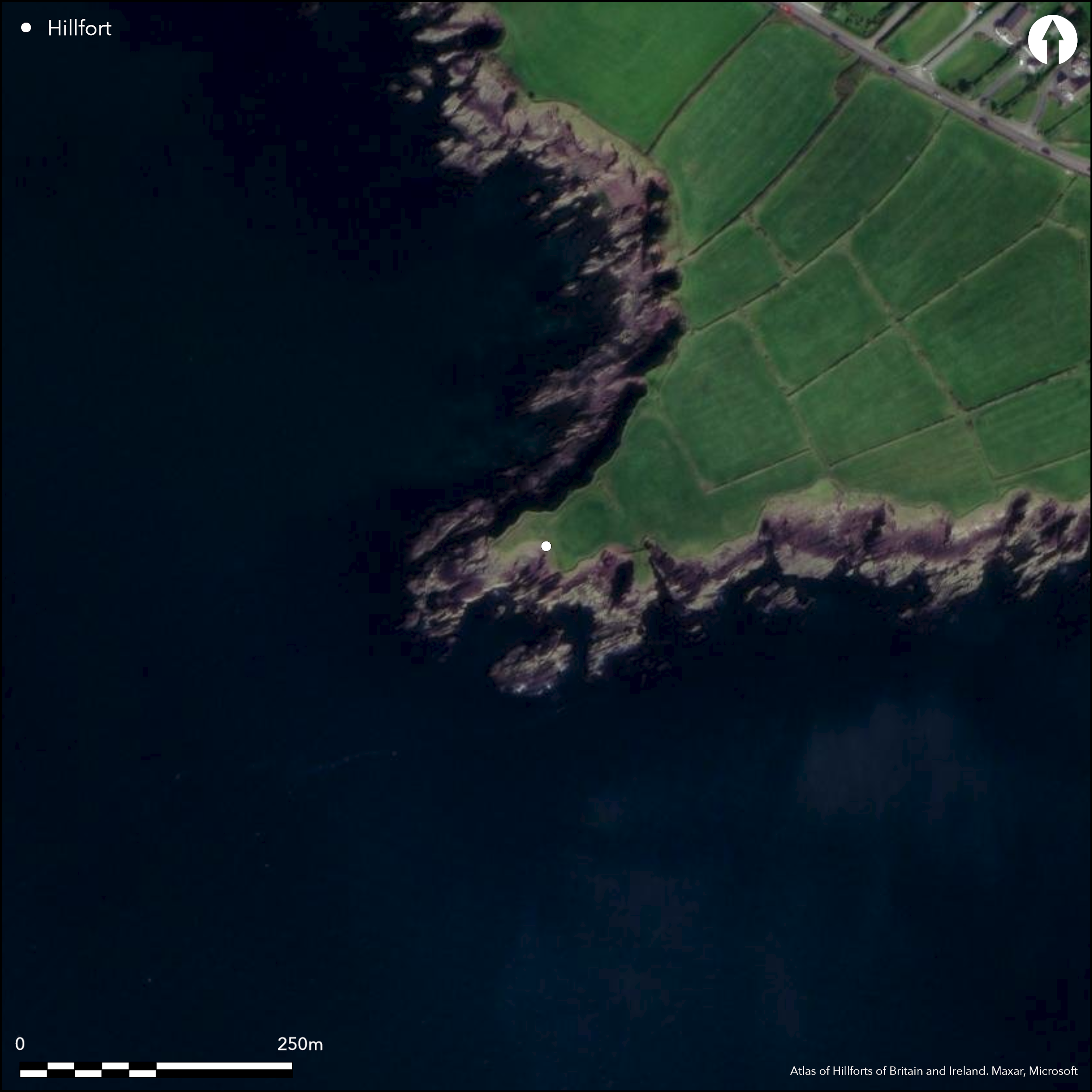
This coastal promontory, known locally as ÇAn D–in'n' is located at Ballymore Point on the E end of Ventry Harbour, Co. Kerry. The site is depicted on the second edition six-inch and twenty-five-inch OS maps (1895). It projects SW from the mainland at an altitude of 3m OD and consists of a level NE-SW headland, to which access is barred midway along by a low bank and external ditch that extend 28m across from the NW cliff edge. The bank is c. 1m high and 2m wide and the ditch measures 0.5m deep and c. 1.25m wide. A wall, interpreted as a later feature to the site with a shallow internal ditch, skirts the edge of the cliff isolating two smaller promontories to the SW and S (O'Sullivan and Sheehan 1996). A rectangular hut-site measuring 3m by 4.5m is recorded at the rear of the SE end of the bank across the neck, while at the W end of the promontory is another D-shaped example measuring 2.2m by 2m with earthen banks less than 0.3m high. A larger depression to the E is interpreted as a possible quarry pit. There are no other recorded features within the interior of the promontory and the headland is currently under pasture.
Citizen Science: ✗
Reliability of Data: Confirmed
Reliability of Interpretation: Confirmed
X: -1150597 Y: 6822124 (EPSG: 3857)
Longitude: -10.335993175145962 Latitude: 52.121501446791974 (EPSG:4326)
Country: Republic of Ireland
Current County or Unitary Authority: Kerry
Historic County: Kerry
Current Parish/Community/Council/Townland: Ballymore West
None
| Extant | ✓ |
| Cropmark | ✗ |
| Likely Destroyed | ✗ |
None
| Woodland | ✗ |
| Commercial Forestry Plantation | ✗ |
| Parkland | ✗ |
| Pasture (Grazing) | ✓ |
| Arable | ✗ |
| Scrub/Bracken | ✗ |
| Bare Outcrop | ✗ |
| Heather/Moorland | ✗ |
| Heath | ✗ |
| Built-up | ✗ |
| Coastal Grassland | ✗ |
| Other | ✗ |
This coastal promontory is located at Ballymore Point on the E end of Ventry Harbour, Co. Kerry. A level NE-SW headland, access is barred by a low bank and external ditch that extend 28m across from the NW cliff edge.
| Contour Fort | ✗ |
| Partial Contour Fort | ✗ |
| Promontory Fort | ✓ |
| Hillslope Fort | ✗ |
| Level Terrain Fort | ✗ |
| Marsh Fort | ✗ |
| Multiple Enclosure Fort | ✗ |
| Hilltop | ✗ |
| Coastal Promontory | ✓ |
| Inland Promontory | ✗ |
| Valley Bottom | ✗ |
| Knoll/Hillock/Outcrop | ✗ |
| Ridge | ✗ |
| Cliff/Plateau-edge/Scarp | ✗ |
| Hillslope | ✗ |
| Lowland | ✗ |
| Spur | ✗ |
Dominant Topographic Feature: None
| North | ✗ |
| Northeast | ✗ |
| East | ✗ |
| Southeast | ✗ |
| South | ✗ |
| Southwest | ✗ |
| West | ✗ |
| Northwest | ✗ |
| Level | ✓ |
Altitude: 3.0m
N/A
There is no dating available for the site
Reliability: D - None
| Pre 1200BC | ✗ |
| 1200BC - 800BC | ✗ |
| 800BC - 400BC | ✗ |
| 400BC - AD50 | ✗ |
| AD50 - AD400 | ✗ |
| AD400 - AD 800 | ✗ |
| Post AD800 | ✗ |
| Unknown | ✓ |
| Pre Hillfort: | None |
| Post Hillfort: | Possible quarry pit. A later wall with a slight internal ditch skirts the edge of the cliff isolating two smaller promontories to the SW and S. |
The site is depicted on the second edition six-inch and twenty-five inch OS maps (1895). Surveyed by Westropp in 1910, and visited for the Dingle Peninsula Archaeological Survey in the mid-1980s (Cuppage et al. 1986).
| 1st Identified Map Depiction (1895): | Second edition OS six-inch mapping |
| 1st Identified Written Reference (1910): | Westropp |
| Earthwork Survey (1986): | Cuppage |
| Earthwork Survey (1996): | O'Sullivan and Sheehan |
A rectangular hut-site measuring 3m by 4.5m is recorded at the rear of the bank at its SE end. At the W end of the promontory is another D-shaped example measuring 2.2m by 2m with earthen banks less than 0.3m high. A larger depression to the E is interpreted as a possible quarry pit.
None
| None | ✓ |
| Spring | ✗ |
| Stream | ✗ |
| Pool | ✗ |
| Flush | ✗ |
| Well | ✗ |
| Other | ✗ |
None
| No Known Features | ✗ |
| Round Stone Structures | ✗ |
| Rectangular Stone Structures | ✓ |
| Curvilinear Platforms | ✗ |
| Other Roundhouse Evidence | ✗ |
| Pits | ✗ |
| Quarry Hollows | ✓ |
| Other | ✓ |
None
| No Known Excavation | ✓ |
| Pits | ✗ |
| Postholes | ✗ |
| Roundhouses | ✗ |
| Rectangular Structures | ✗ |
| Roads/Tracks | ✗ |
| Quarry Hollows | ✗ |
| Other | ✗ |
| Nothing Found | ✗ |
None
| No Known Geophysics | ✓ |
| Pits | ✗ |
| Roundhouses | ✗ |
| Rectangular Structures | ✗ |
| Roads/Tracks | ✗ |
| Quarry Hollows | ✗ |
| Other | ✗ |
| Nothing Found | ✗ |
None
| No Known Finds | ✓ |
| Pottery | ✗ |
| Metal | ✗ |
| Metalworking | ✗ |
| Human Bones | ✗ |
| Animal Bones | ✗ |
| Lithics | ✗ |
| Environmental | ✗ |
| Other | ✗ |
NO APPARENT FEATURES
| APs Not Checked | ✗ |
| None | ✓ |
| Roundhouses | ✗ |
| Rectangular Structures | ✗ |
| Pits | ✗ |
| Postholes | ✗ |
| Roads/Tracks | ✗ |
| Other | ✗ |
A break in the bank is depicted on the second edition 25-inch map, however there is no record of this on the ground and it was not recorded when surveyed.
| 0: | None |
| 2: | None |
Guard Chambers: ✗
Chevaux de Frise: ✗
Access midway along the landmass is barred by a low bank and external ditch that extend 28m across from the NW cliff edge. The bank is c. 1m high and 2m wide and the ditch measures 0.5m deep and c. 1.25m wide. A later wall with a slight internal ditch skirts the edge of the cliff isolating two smaller promontories to the SW and S.
| Area 1: | 0.2ha. |
| Total: | 0.2ha. |
Total Footprint Area: 0.21ha.
None
| ✗ | None |
| ✗ | None |
| NE Quadrant: | 1 |
| SE Quadrant: | 0 |
| SW Quadrant: | 0 |
| NW Quadrant: | 0 |
| Total: | 1 |
| Partial Univallate | ✓ |
| Univallate | ✗ |
| Partial Bivallate | ✗ |
| Bivallate | ✗ |
| Partial Multivallate | ✗ |
| Multivallate | ✗ |
| Unknown | ✗ |
| Partial Univallate | ✗ |
| Univallate | ✗ |
| Partial Bivallate | ✗ |
| Bivallate | ✗ |
| Partial Multivallate | ✗ |
| Multivallate | ✗ |
None
| None | ✗ |
| Earthen Bank | ✓ |
| Stone Wall | ✗ |
| Rubble | ✗ |
| Wall-walk | ✗ |
| Evidence of Timber | ✗ |
| Vitrification | ✗ |
| Other Burning | ✗ |
| Palisade | ✗ |
| Counter Scarp Bank | ✗ |
| Berm | ✗ |
| Unfinished | ✗ |
| Other | ✗ |
None
| None | ✗ |
| Earthen Bank | ✗ |
| Stone Wall | ✗ |
| Murus Duplex | ✗ |
| Timber-framed | ✗ |
| Timber-laced | ✗ |
| Vitrification | ✗ |
| Other Burning | ✗ |
| Palisade | ✗ |
| Counter Scarp Bank | ✗ |
| Berm | ✗ |
| Unfinished | ✗ |
| No Known Excavation | ✓ |
| Other | ✗ |
| ✗ | None |
| ✓ | None |
Number of Ditches: 1
| ✗ | None |
Cuppage, J. et al. 1986. Archaeological Survey of the Dingle Peninsula. Ballyferriter
O'Sullivan, A and Sheehan, J. 1996. Iveragh Peninsula: An Archaeological Survey of South Kerry. Cork University Press. Cork
Redmond, M. 1995. A survey of the promontory forts of the Kerry peninsulas. Journal of the Kerry Archaeological and Historical Society 28, 5-63.
Westropp, T.J. 1910. Promontory forts and similar structures of County Kerry. Journal of the Royal Society of Antiquaries of Ireland 40, 179-213, 265-196.
Atlas of Hillforts:
Wikidata:
This work is licensed under CC BY-SA 4.0![]()
![]()
![]() and should be cited as:
and should be cited as:
Lock, Gary and Ralston, Ian. 2024. Atlas of Hillforts of Britain and Ireland. Available at: https://hillforts.arch.ox.ac.uk
Document Version 1.1