Satellite Imagery
Satellite Imagery
HER: Archaeological Survey of Ireland SMR Database KE028-002002 (None)
NMR: KE 028 (None)
SM: None
NGR: None
X: 472552 Y: 618402 (IRENET95)
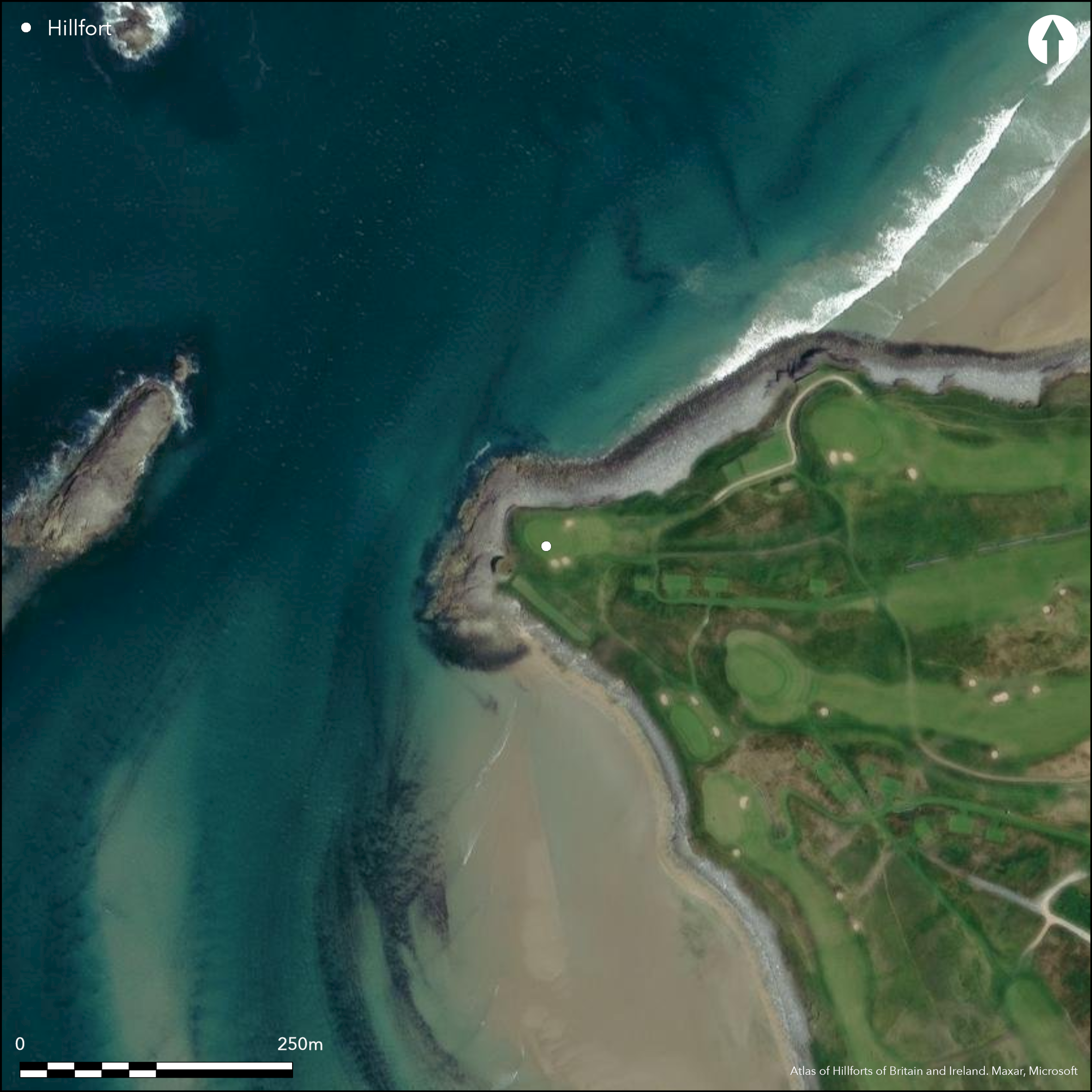
This coastal promontory is located at Barrow Harbour, c. 3km N of Fenit in Co. Kerry. Situated on the S end of Banna Strand, barely projecting NW from the mainland over precipitous cliffs, the headland has now been developed into a golf course. Defended on the landward side by a bank and an internal rock-cut ditch 83m long. The outer earthen bank is 2.9m wide, 0.42m high externally while the ditch is 4.7m wide and 0.77m deep from within (Redmond 1995, 10). Besides the Medieval tower house situated at the W tip of the promontory, no other structures are recorded within the interior. The fort has suffered considerably from the golf course development as the entire interior has been landscaped with the building of a level terrace on the S side. 30m of the defences have been razed for an associated fairway. The defences have also been damaged by a trackway towards the S end which has resulted in the removal of 8m of the bank and the infilling of the ditch (Redmond 1995, 10).
Citizen Science: ✗
Reliability of Data: Confirmed
Reliability of Interpretation: Confirmed
X: -1098586 Y: 6855001 (EPSG: 3857)
Longitude: -9.868770012073952 Latitude: 52.30246641413904 (EPSG:4326)
Country: Republic of Ireland
Current County or Unitary Authority: Kerry
Historic County: Kerry
Current Parish/Community/Council/Townland: Barrow
The entire interior has been landscaped with the building of a level terrace on the S side. 30m of the defences have been razed for an associated fairway.The defences have also been damaged by a trackway towards the S end which has resulted in the removal of 8m of the bank and the infilling of the ditch
| Extant | ✓ |
| Cropmark | ✗ |
| Likely Destroyed | ✓ |
The promontory fort has been incorporated into modern golf course.
| Woodland | ✗ |
| Commercial Forestry Plantation | ✗ |
| Parkland | ✗ |
| Pasture (Grazing) | ✗ |
| Arable | ✗ |
| Scrub/Bracken | ✗ |
| Bare Outcrop | ✗ |
| Heather/Moorland | ✗ |
| Heath | ✗ |
| Built-up | ✗ |
| Coastal Grassland | ✗ |
| Other | ✓ |
This destroyed coastal promontory is situated on the S end of Banna Strand, barely projecting NW from the mainland over precipitous cliffs at an altitude of 5m OD. The headland has now been developed into a golf course and was once defended on the landward side by a bank and an internal rock-cut ditch 83m long
| Contour Fort | ✗ |
| Partial Contour Fort | ✗ |
| Promontory Fort | ✓ |
| Hillslope Fort | ✗ |
| Level Terrain Fort | ✗ |
| Marsh Fort | ✗ |
| Multiple Enclosure Fort | ✗ |
| Hilltop | ✗ |
| Coastal Promontory | ✓ |
| Inland Promontory | ✗ |
| Valley Bottom | ✗ |
| Knoll/Hillock/Outcrop | ✗ |
| Ridge | ✗ |
| Cliff/Plateau-edge/Scarp | ✗ |
| Hillslope | ✗ |
| Lowland | ✗ |
| Spur | ✗ |
Dominant Topographic Feature: None
| North | ✗ |
| Northeast | ✗ |
| East | ✗ |
| Southeast | ✗ |
| South | ✗ |
| Southwest | ✗ |
| West | ✗ |
| Northwest | ✗ |
| Level | ✓ |
Altitude: 5.0m
N/A
There is no dating available for the site
Reliability: D - None
| Pre 1200BC | ✗ |
| 1200BC - 800BC | ✗ |
| 800BC - 400BC | ✗ |
| 400BC - AD50 | ✗ |
| AD50 - AD400 | ✗ |
| AD400 - AD 800 | ✗ |
| Post AD800 | ✗ |
| Unknown | ✓ |
| Pre Hillfort: | None |
| Post Hillfort: | Medieval tower house recorded to the W. The promontory has been developed into a golf course. |
The site is recorded on the first edition six-inch OS map (1841). Visited and surveyed by Marcus Redmond in 1995 who recorded defences.
| 1st Identified Map Depiction (1841): | OS six-inch mapping |
| Earthwork Survey (1995): | Redmond |
Besides the Medieval tower house, no other structures are recorded within the interior. The fort has suffered considerably from the golf course development as the entire interior has been landscaped with the building of a level terrace on the S side.
None
| None | ✓ |
| Spring | ✗ |
| Stream | ✗ |
| Pool | ✗ |
| Flush | ✗ |
| Well | ✗ |
| Other | ✗ |
Medieval tower house
| No Known Features | ✗ |
| Round Stone Structures | ✗ |
| Rectangular Stone Structures | ✗ |
| Curvilinear Platforms | ✗ |
| Other Roundhouse Evidence | ✗ |
| Pits | ✗ |
| Quarry Hollows | ✗ |
| Other | ✓ |
None
| No Known Excavation | ✓ |
| Pits | ✗ |
| Postholes | ✗ |
| Roundhouses | ✗ |
| Rectangular Structures | ✗ |
| Roads/Tracks | ✗ |
| Quarry Hollows | ✗ |
| Other | ✗ |
| Nothing Found | ✗ |
None
| No Known Geophysics | ✓ |
| Pits | ✗ |
| Roundhouses | ✗ |
| Rectangular Structures | ✗ |
| Roads/Tracks | ✗ |
| Quarry Hollows | ✗ |
| Other | ✗ |
| Nothing Found | ✗ |
None
| No Known Finds | ✓ |
| Pottery | ✗ |
| Metal | ✗ |
| Metalworking | ✗ |
| Human Bones | ✗ |
| Animal Bones | ✗ |
| Lithics | ✗ |
| Environmental | ✗ |
| Other | ✗ |
NO APPARENT FEATURES
| APs Not Checked | ✓ |
| None | ✗ |
| Roundhouses | ✗ |
| Rectangular Structures | ✗ |
| Pits | ✗ |
| Postholes | ✗ |
| Roads/Tracks | ✗ |
| Other | ✗ |
There are no recorded entrances to the site. The defences have suffered greatly by modern development.
| 0: | None |
| 2: | None |
Guard Chambers: ✗
Chevaux de Frise: ✗
Defended on the landward side by a bank and an internal rock-cut ditch 83m long. The outer earthen bank is 2.9m wide by 0.42m high externally, while the ditch is 4.7m wide and 0.77m deep internally. The defences have also been damaged by a trackway towards the S end which has resulted in the removal of 8m of the bank and the infilling of the ditch.
| Area 1: | 0.29ha. |
| Total: | 0.29ha. |
Total Footprint Area: 0.43ha.
None
| ✗ | None |
| ✗ | None |
| NE Quadrant: | 1 |
| SE Quadrant: | 1 |
| SW Quadrant: | 0 |
| NW Quadrant: | 0 |
| Total: | 1 |
| Partial Univallate | ✓ |
| Univallate | ✗ |
| Partial Bivallate | ✗ |
| Bivallate | ✗ |
| Partial Multivallate | ✗ |
| Multivallate | ✗ |
| Unknown | ✗ |
| Partial Univallate | ✗ |
| Univallate | ✗ |
| Partial Bivallate | ✗ |
| Bivallate | ✗ |
| Partial Multivallate | ✗ |
| Multivallate | ✗ |
None
| None | ✗ |
| Earthen Bank | ✓ |
| Stone Wall | ✗ |
| Rubble | ✗ |
| Wall-walk | ✗ |
| Evidence of Timber | ✗ |
| Vitrification | ✗ |
| Other Burning | ✗ |
| Palisade | ✗ |
| Counter Scarp Bank | ✗ |
| Berm | ✗ |
| Unfinished | ✗ |
| Other | ✗ |
None
| None | ✗ |
| Earthen Bank | ✗ |
| Stone Wall | ✗ |
| Murus Duplex | ✗ |
| Timber-framed | ✗ |
| Timber-laced | ✗ |
| Vitrification | ✗ |
| Other Burning | ✗ |
| Palisade | ✗ |
| Counter Scarp Bank | ✗ |
| Berm | ✗ |
| Unfinished | ✗ |
| No Known Excavation | ✓ |
| Other | ✗ |
| ✗ | None |
| ✓ | Internal rock-cut ditch |
Number of Ditches: 1
| ✗ | None |
Redmond, M. 1995. A survey of the promontory forts of the Kerry peninsulas. Journal of the Kerry Archaeological and Historical Society 28, 5-63
Atlas of Hillforts:
Wikidata:
This work is licensed under CC BY-SA 4.0![]()
![]()
![]() and should be cited as:
and should be cited as:
Lock, Gary and Ralston, Ian. 2024. Atlas of Hillforts of Britain and Ireland. Available at: https://hillforts.arch.ox.ac.uk
Document Version 1.1