Satellite Imagery
Satellite Imagery
HER: Archaeological Survey of Ireland SMR Database DU023-029001 (None)
NMR: DU 023 (None)
SM: None
NGR: None
X: 727613 Y: 726510 (IRENET95)
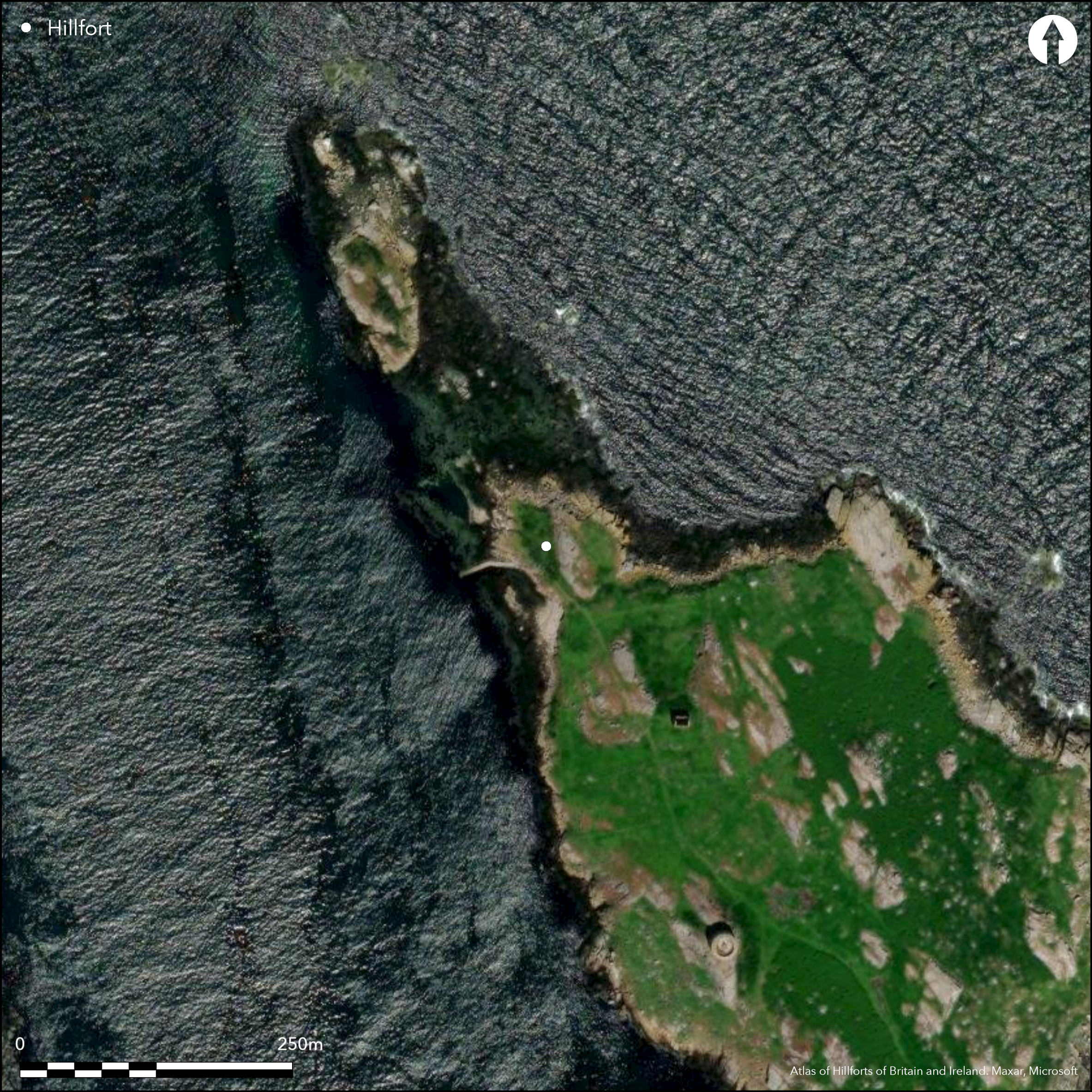
This coastal promontory is situated on Dalkey Island which is separated from the S Dublin coastline by a fast-flowing tidal sound approximately 400m in width. When viewed from the mainland it is dominated by a small church and by nineteenth century fortifications in the form of a gun battery and Martello tower on the S end. The name 'Dalke'y appears to be a Norse translation of the Irish name 'Deilginis' or 'Thorn Island' (Ofedal 1975; Doyle 1998). The promontory fort comprises a small headland cut off On the SE by a low bank with a partially back-filled external ditch enclosing an area of approximately 0.25ha. It is situated at an altitude of 7m OD. Slight evidence of a possible entrance on the SE was recovered during excavation in the 1950's (Liversage 1968); it consisted of several post-holes, including two with stone packing. The interior is divided into two levels by a low granite cliff that runs from N to S. The lower part on the W overlooks the landing area or harbour while the upper on the E is some 3m higher and is more exposed. Excavations revealed that temporary encampments had been intermittently established on the island in the Neolithic and Bronze Age (Liversage 1968). Beneath the promontory fort bank an early medieval shell midden was uncovered, from which sherds of Late Roman Amphorae and three bronze pins were recovered. Two sherds of Samian Ware, further sherds of Late Roman Amphorae, and Gaulish/Frankish E ware pottery were also recovered during the excavation, and Dalkey Island appears to have continued as an important trading post well into the latter centuries of the early medieval period (Liversage 1968, 179-81). A house, midden and hearth post-dated the promontory fort. Based on finds recovered, it would appear that this house was constructed and abandoned during the early medieval period (O'Sullivan et al. 2010). Analysis of the finds and their stratigraphic levels would indicate that the promontory fort was constructed during the Early Medieval period (Doyle 1998, 90).
Citizen Science: ✗
Reliability of Data: Confirmed
Reliability of Interpretation: Confirmed
X: -677564 Y: 7033758 (EPSG: 3857)
Longitude: -6.086663995420825 Latitude: 53.27354831400343 (EPSG:4326)
Country: Republic of Ireland
Current County or Unitary Authority: Dublin
Historic County: Dublin
Current Parish/Community/Council/Townland: Dlakey Island
None
| Extant | ✓ |
| Cropmark | ✗ |
| Likely Destroyed | ✗ |
None
| Woodland | ✗ |
| Commercial Forestry Plantation | ✗ |
| Parkland | ✗ |
| Pasture (Grazing) | ✓ |
| Arable | ✗ |
| Scrub/Bracken | ✗ |
| Bare Outcrop | ✗ |
| Heather/Moorland | ✓ |
| Heath | ✗ |
| Built-up | ✗ |
| Coastal Grassland | ✗ |
| Other | ✗ |
The promontory fort is composed of a small headland cut off by a low bank with a partially back-filled external ditch enclosing an area of approximately 0.25ha. The internal area is divided into two platforms by a low granite cliff that runs from N to S. The W platfrom overlooks the landing area or harbour while the E platform is some 3m higher and is more exposed as a result. It is situated on Dalkey Island which is separated from the S Dublin coastline by a fast-flowing tidal sound approximately 400m in width. It is situated at an altitude of 4-7m OD
| Contour Fort | ✗ |
| Partial Contour Fort | ✗ |
| Promontory Fort | ✓ |
| Hillslope Fort | ✗ |
| Level Terrain Fort | ✗ |
| Marsh Fort | ✗ |
| Multiple Enclosure Fort | ✗ |
| Hilltop | ✗ |
| Coastal Promontory | ✓ |
| Inland Promontory | ✗ |
| Valley Bottom | ✗ |
| Knoll/Hillock/Outcrop | ✗ |
| Ridge | ✗ |
| Cliff/Plateau-edge/Scarp | ✗ |
| Hillslope | ✗ |
| Lowland | ✗ |
| Spur | ✗ |
Dominant Topographic Feature: Overlooked to the S
| North | ✗ |
| Northeast | ✗ |
| East | ✗ |
| Southeast | ✗ |
| South | ✗ |
| Southwest | ✗ |
| West | ✗ |
| Northwest | ✓ |
| Level | ✗ |
Altitude: 7.0m
N/A
Given the stratification of B ware and E ware ware in the pre-bank layers a probable mid-sixth or seventh century date may be put forward for the construction of the defences. The evidence from the interior suggest that the site continued to be used into the seventh century AD.
Reliability: B - Medium
| Pre 1200BC | ✗ |
| 1200BC - 800BC | ✗ |
| 800BC - 400BC | ✗ |
| 400BC - AD50 | ✗ |
| AD50 - AD400 | ✗ |
| AD400 - AD 800 | ✓ |
| Post AD800 | ✗ |
| Unknown | ✗ |
| Pre Hillfort: | None |
| Post Hillfort: | None |
| Artefactual: | Samian Ware, sherds of Late Roman Amphorae, and Gaulish/Frankish E ware; three bronze pins |
The promontory is not depicted on any edition of the OS six-inch maps. Excavated by G.D Liversage during the 1950's with the intention to facilitate conservation work on the Medieval church. However, the opportunity was taken to investigate the origins of the promontory fort on the N part of the island. The results of these excavations were re-assessed in 1998 by Ian Doyle.
| Other (1998): | Ian Doyle reassessment |
| Excavation (None): | G.D Liversage |
Trenches excavated in the N portion of Site II revealed a prehistoric shell midden and prehistoric burials. An Early Meideval hearth and possible kiln/oven were also uncovered along with Early Medieval domestic artefacts such as worked bone, iron nails, Bronze pins and a whetstone. The remains of an Early Medieval house were revealed abutting the bank on the upper level on the E composed of an occupation layer delimited by posts along with a central hearth. It partially overlay the bank suggesting it was either contemporary with it or post-dated it. Trial trenches on the lower level on the W uncovered prehistoric activity in the form of burials, midden spreads and pits. Medieval pits and an iron working pit were also recovered here (Liversage 1968; Doyle 1998).
A well is recorded on the OS maps situated approximately 80m SW of the defenses
| None | ✓ |
| Spring | ✗ |
| Stream | ✗ |
| Pool | ✗ |
| Flush | ✗ |
| Well | ✗ |
| Other | ✗ |
None
| No Known Features | ✓ |
| Round Stone Structures | ✗ |
| Rectangular Stone Structures | ✗ |
| Curvilinear Platforms | ✗ |
| Other Roundhouse Evidence | ✗ |
| Pits | ✗ |
| Quarry Hollows | ✗ |
| Other | ✗ |
None
| No Known Excavation | ✗ |
| Pits | ✓ |
| Postholes | ✓ |
| Roundhouses | ✗ |
| Rectangular Structures | ✓ |
| Roads/Tracks | ✗ |
| Quarry Hollows | ✗ |
| Other | ✗ |
| Nothing Found | ✗ |
None
| No Known Geophysics | ✓ |
| Pits | ✗ |
| Roundhouses | ✗ |
| Rectangular Structures | ✗ |
| Roads/Tracks | ✗ |
| Quarry Hollows | ✗ |
| Other | ✗ |
| Nothing Found | ✗ |
None
| No Known Finds | ✗ |
| Pottery | ✓ |
| Metal | ✓ |
| Metalworking | ✓ |
| Human Bones | ✓ |
| Animal Bones | ✓ |
| Lithics | ✓ |
| Environmental | ✗ |
| Other | ✗ |
NO APPARENT FEATURES
| APs Not Checked | ✓ |
| None | ✗ |
| Roundhouses | ✗ |
| Rectangular Structures | ✗ |
| Pits | ✗ |
| Postholes | ✗ |
| Roads/Tracks | ✗ |
| Other | ✗ |
Slight evidence of a possible entrance was recovered during excavation in the 1950's (Liversage 1968). It consisted of several post-holes, including two with stone packing
| 0: | None |
| 2: | None |
Guard Chambers: ✗
Chevaux de Frise: ✗
| 1. Simple Gap (South east): | None |
The promontory fort comprises of a small headland cut off by a low bank with a partially back-filled external ditch. The bank consisted of the upcast from the ditch and the dark crumbly occupation layer, having a height of approximately 1.5m. It showed no indication of having been revetted or of having held a palisade. The ditch is 5m wide with sloping sides and a maximum depth of 2.4m. There was no evidence of re-cutting. Two sherds of Bii amphora were recovered from the middle fill of the ditch while a child burial was found in the upper layers along with medieval pottery.
| Area 1: | 0.25ha. |
| Total: | 0.25ha. |
Total Footprint Area: 0.29ha.
None
| ✗ | None |
| ✗ | None |
| NE Quadrant: | 0 |
| SE Quadrant: | 1 |
| SW Quadrant: | 0 |
| NW Quadrant: | 0 |
| Total: | 1 |
| Partial Univallate | ✓ |
| Univallate | ✗ |
| Partial Bivallate | ✗ |
| Bivallate | ✗ |
| Partial Multivallate | ✗ |
| Multivallate | ✗ |
| Unknown | ✗ |
| Partial Univallate | ✗ |
| Univallate | ✗ |
| Partial Bivallate | ✗ |
| Bivallate | ✗ |
| Partial Multivallate | ✗ |
| Multivallate | ✗ |
None
| None | ✗ |
| Earthen Bank | ✓ |
| Stone Wall | ✗ |
| Rubble | ✗ |
| Wall-walk | ✗ |
| Evidence of Timber | ✗ |
| Vitrification | ✗ |
| Other Burning | ✗ |
| Palisade | ✗ |
| Counter Scarp Bank | ✗ |
| Berm | ✗ |
| Unfinished | ✗ |
| Other | ✗ |
None
| None | ✗ |
| Earthen Bank | ✓ |
| Stone Wall | ✗ |
| Murus Duplex | ✗ |
| Timber-framed | ✗ |
| Timber-laced | ✗ |
| Vitrification | ✗ |
| Other Burning | ✗ |
| Palisade | ✗ |
| Counter Scarp Bank | ✗ |
| Berm | ✗ |
| Unfinished | ✗ |
| No Known Excavation | ✗ |
| Other | ✗ |
| ✗ | None |
| ✓ | rock-cut ditch |
Number of Ditches: 1
| ✗ | None |
Doyle, I. W. 1998. The early medieval activity at Dalkey Island, Co. Dublin: a re-assessment. Journal of Irish Archaeology 9, 89-103
Liversage, G. D. 1968. Excavations at Dalkey Island, Co. Dublin 1956-1959. Proceedings of the Royal Irish Academy 66C, 53-233
Atlas of Hillforts:
Wikidata:
This work is licensed under CC BY-SA 4.0![]()
![]()
![]() and should be cited as:
and should be cited as:
Lock, Gary and Ralston, Ian. 2024. Atlas of Hillforts of Britain and Ireland. Available at: https://hillforts.arch.ox.ac.uk
Document Version 1.1