Satellite Imagery
Satellite Imagery
HER: Archaeological Survey of Ireland SMR Database CL051-045 (None)
NMR: CL 051 (None)
SM: None
NGR: None
X: 535985 Y: 664747 (IRENET95)
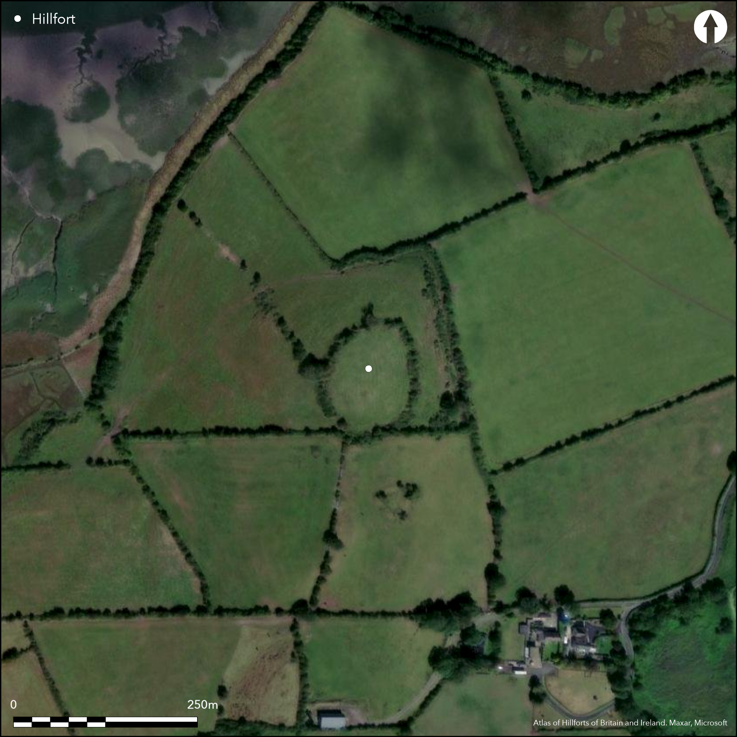
Located 5km to the W of Newmarket-on-Fergus, oval contour fort of approximately 0.8ha is positioned strategically on the domed summit of a drumlin with extensive views overlooking the Fergus estury to the N and W and low-lying terrain to the E and S; Clenagh Creek lies to the immediate N. The fort is extant and comprises a substantial bank, external ditch and counterscarp bank, which are well-preserved on the NE and E. The outer bank has been incorporated into a modern field system and has been altered, particularly at the S and W and NE. A low linear bank was identified by topographical survey within the interior. No other obvious surface features are apparent. There is a simple gap on the NE. The interior is under pasture and the enclosing elements are covered in gorse and bracken. Excavation by Grogan found no artefacts or features that could date the site and no datable features. Some possible post- and stake-holes were identified in the interior, although this area was heavily disturbed. First depicted in the first edition Ordnance Survey maps as a circular enclosure with a thick bank. A more detailed earthwork survey was undertaken during the completion of the second edition Ordnance Survey mapping program. Westropp (1913, 65) surveyed and described the monument in 1913. Grogan undertook topographical and resistance surveys prior to excavating the site in 1994.
Citizen Science: ✗
Reliability of Data: Confirmed
Reliability of Interpretation: Confirmed
X: -996062 Y: 6933214 (EPSG: 3857)
Longitude: -8.947776639130886 Latitude: 52.73002074198517 (EPSG:4326)
Country: Republic of Ireland
Current County or Unitary Authority: Clare
Historic County: Clare
Current Parish/Community/Council/Townland: Clenagh
None
| Extant | ✓ |
| Cropmark | ✗ |
| Likely Destroyed | ✗ |
None
| Woodland | ✗ |
| Commercial Forestry Plantation | ✗ |
| Parkland | ✗ |
| Pasture (Grazing) | ✓ |
| Arable | ✗ |
| Scrub/Bracken | ✗ |
| Bare Outcrop | ✗ |
| Heather/Moorland | ✗ |
| Heath | ✗ |
| Built-up | ✗ |
| Coastal Grassland | ✗ |
| Other | ✗ |
Oval contour fort positioned at the summit of a drumlin top. The site is strategically positioned with extensive views of the Fergus estuary to the N and W and low-lying terrain to the E and S.
| Contour Fort | ✓ |
| Partial Contour Fort | ✗ |
| Promontory Fort | ✗ |
| Hillslope Fort | ✗ |
| Level Terrain Fort | ✗ |
| Marsh Fort | ✗ |
| Multiple Enclosure Fort | ✗ |
| Hilltop | ✓ |
| Coastal Promontory | ✗ |
| Inland Promontory | ✗ |
| Valley Bottom | ✗ |
| Knoll/Hillock/Outcrop | ✓ |
| Ridge | ✗ |
| Cliff/Plateau-edge/Scarp | ✗ |
| Hillslope | ✗ |
| Lowland | ✗ |
| Spur | ✗ |
Dominant Topographic Feature: Drumlin.
| North | ✗ |
| Northeast | ✗ |
| East | ✗ |
| Southeast | ✗ |
| South | ✗ |
| Southwest | ✗ |
| West | ✗ |
| Northwest | ✗ |
| Level | ✓ |
Altitude: 40.0m
N/A
Grogans excavations of the hilltop enclosure at Clenagh, Co. Clare did not produce any construction dates or artefacts that could date the occupation of the monument. Two radiocarbon dates from the upper levels of the ditch produced dates ranging 405 - 561 AD, suggesting a pre Early Medieval date for construction and occupation.
Reliability: D - None
| Pre 1200BC | ✗ |
| 1200BC - 800BC | ✗ |
| 800BC - 400BC | ✗ |
| 400BC - AD50 | ✗ |
| AD50 - AD400 | ✗ |
| AD400 - AD 800 | ✗ |
| Post AD800 | ✗ |
| Unknown | ✓ |
| Pre Hillfort: | None |
| Post Hillfort: | None |
| C14: | Unreliable due to the context of the dates themselves. |
First depicted in the first edition Ordnance Survey maps as a circular enclosure with a thick bank. A more detailed earthwork survey was undertaken during the completion of the second edition Ordnance Survey mapping program. Westropp (1913, 65) surveyed and described the monument in 1913. Grogan undertook topographical and resistance surveys prior to excavating the site in 1994.
| 1st Identified Map Depiction (1842): | First edition Ordnance Survey 6 inch mapping. |
| Earthwork Survey (1906): | Second edition Ordnance Survey 25 inch mapping. |
| Other (1913): | Survey and description by Westropp. |
| Earthwork Survey (1994): | Topographical survey by Grogan (2005) |
| Geophysical Survey (1994): | Geophysical survey by Grogan (2005) |
| Excavation (1994): | Excavation by Grogan (2005). |
A linear field bank is apparent in a topographical survey undertaken by Grogan (2005, 248). Upon excavation, some possible post- and stake-holes were identified in the interior, although this area was heavily disturbed.
None
| None | ✓ |
| Spring | ✗ |
| Stream | ✗ |
| Pool | ✗ |
| Flush | ✗ |
| Well | ✗ |
| Other | ✗ |
None
| No Known Features | ✓ |
| Round Stone Structures | ✗ |
| Rectangular Stone Structures | ✗ |
| Curvilinear Platforms | ✗ |
| Other Roundhouse Evidence | ✗ |
| Pits | ✗ |
| Quarry Hollows | ✗ |
| Other | ✗ |
None
| No Known Excavation | ✗ |
| Pits | ✗ |
| Postholes | ✓ |
| Roundhouses | ✗ |
| Rectangular Structures | ✗ |
| Roads/Tracks | ✗ |
| Quarry Hollows | ✗ |
| Other | ✗ |
| Nothing Found | ✗ |
Unknown
| No Known Geophysics | ✗ |
| Pits | ✗ |
| Roundhouses | ✗ |
| Rectangular Structures | ✗ |
| Roads/Tracks | ✗ |
| Quarry Hollows | ✗ |
| Other | ✗ |
| Nothing Found | ✓ |
None
| No Known Finds | ✓ |
| Pottery | ✗ |
| Metal | ✗ |
| Metalworking | ✗ |
| Human Bones | ✗ |
| Animal Bones | ✗ |
| Lithics | ✗ |
| Environmental | ✗ |
| Other | ✗ |
NO APPARENT FEATURES
| APs Not Checked | ✓ |
| None | ✗ |
| Roundhouses | ✗ |
| Rectangular Structures | ✗ |
| Pits | ✗ |
| Postholes | ✗ |
| Roads/Tracks | ✗ |
| Other | ✗ |
Simple break in the enclosing elements at the NE is likely to be original. Depicted in second edition Ordnance Survey maps.
| 1: | None |
| 2: | None |
Guard Chambers: ✗
Chevaux de Frise: ✗
| 1. Simple Gap (North east): | None |
A substantial bank, U-shaped ditch and conterscarp bank defines this oval contour fort. The ditch is on average 5m wide and 1.5m-1.8m deep below the top of the inner bank (Grogan 2005, 251). The width of the bank varies from 1.5m to 3.8m and the height ranges from 0.5m to 0.8m (Grogan 2005, 251). A contiguous line of boulders at the outer face of the bank may have formed a revetment. The site has a total footprint of approximately 0.8ha.
| Area 1: | 0.43ha. |
| Total: | 0.43ha. |
Total Footprint Area: 0.84ha.
None
| ✗ | None |
| ✓ | Internal bank with an external ditch and counterscarp. |
| NE Quadrant: | 1 |
| SE Quadrant: | 1 |
| SW Quadrant: | 1 |
| NW Quadrant: | 1 |
| Total: | 1 |
| Partial Univallate | ✗ |
| Univallate | ✓ |
| Partial Bivallate | ✗ |
| Bivallate | ✗ |
| Partial Multivallate | ✗ |
| Multivallate | ✗ |
| Unknown | ✗ |
| Partial Univallate | ✗ |
| Univallate | ✗ |
| Partial Bivallate | ✗ |
| Bivallate | ✗ |
| Partial Multivallate | ✗ |
| Multivallate | ✗ |
None
| None | ✗ |
| Earthen Bank | ✓ |
| Stone Wall | ✗ |
| Rubble | ✗ |
| Wall-walk | ✗ |
| Evidence of Timber | ✗ |
| Vitrification | ✗ |
| Other Burning | ✗ |
| Palisade | ✗ |
| Counter Scarp Bank | ✓ |
| Berm | ✗ |
| Unfinished | ✗ |
| Other | ✗ |
Earthen bank with possible external boulder revetment. U-shaped ditch.
| None | ✗ |
| Earthen Bank | ✓ |
| Stone Wall | ✗ |
| Murus Duplex | ✗ |
| Timber-framed | ✗ |
| Timber-laced | ✗ |
| Vitrification | ✗ |
| Other Burning | ✗ |
| Palisade | ✗ |
| Counter Scarp Bank | ✗ |
| Berm | ✗ |
| Unfinished | ✗ |
| No Known Excavation | ✗ |
| Other | ✓ |
| ✗ | None |
| ✓ | External ditch and counterscarp bank. |
Number of Ditches: 1
| ✗ | None. There is a possible Early Medieval ringfort approximately 40m to the south of the contour fort. |
Westropp, T. 1913. Types of ring-forts remaining in eastern Clare (Clonlara, Broadford, Cullaun, and Clooney). Proceedings of the Royal Irish Academy 32 C, 58 - 77.
Grogan, E. 2005. The North Munster Project Vol. 1: The Later Prehistoric Landscape of South-East Clare. Wordwell, Dublin.
Atlas of Hillforts:
Wikidata:
This work is licensed under CC BY-SA 4.0![]()
![]()
![]() and should be cited as:
and should be cited as:
Lock, Gary and Ralston, Ian. 2024. Atlas of Hillforts of Britain and Ireland. Available at: https://hillforts.arch.ox.ac.uk
Document Version 1.1