Satellite Imagery
Satellite Imagery
HER: Archaeological Survey of Ireland SMR Database DU019-004002 (None)
NMR: DU 019 (None)
SM: None
NGR: None
X: 727977 Y: 737875 (IRENET95)
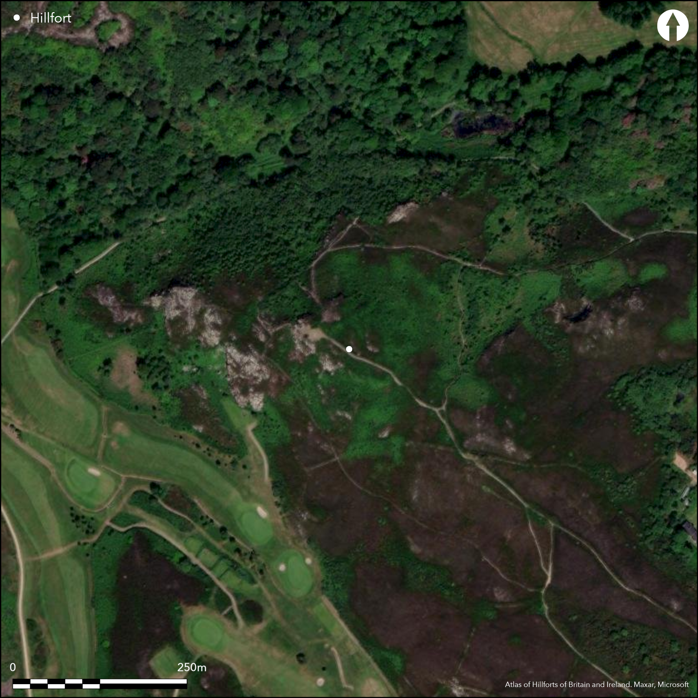
In a strategic position with panoramic views from the summit, overlooking Howth harbour to the N and Dublin bay to the S, this small contour fort crowns the summit of a natural knoll. The entire site is surrounded by a much denuded stone bank recorded by Westropp in the early 1920's. The bank is presently under dense scrub and heather growth and is not apparent in aerial photography. There are no obvious entrance features visible on the surface. A cairn and a possible barrow have been identified within the interior of the site. The site does not appear on either edition of the Ordnance Survey maps or any other ancient mapping. Westropp (1922, 58-59) described the site in the early 1920's, suggesting that the enclosing elements were more visible.
Citizen Science: ✗
Reliability of Data: Confirmed
Reliability of Interpretation: Unconfirmed
X: -676447 Y: 7052767 (EPSG: 3857)
Longitude: -6.076623165265825 Latitude: 53.375539989972275 (EPSG:4326)
Country: Republic of Ireland
Current County or Unitary Authority: Dublin
Historic County: Dublin
Current Parish/Community/Council/Townland: Howth
None
| Extant | ✓ |
| Cropmark | ✗ |
| Likely Destroyed | ✗ |
Under dense scrub, bracken and heather.
| Woodland | ✗ |
| Commercial Forestry Plantation | ✗ |
| Parkland | ✗ |
| Pasture (Grazing) | ✗ |
| Arable | ✗ |
| Scrub/Bracken | ✓ |
| Bare Outcrop | ✗ |
| Heather/Moorland | ✓ |
| Heath | ✗ |
| Built-up | ✗ |
| Coastal Grassland | ✗ |
| Other | ✗ |
Contour fort positioned at the edge of a natural knoll that is defined by steep, exposed rock scarp at the N, W and S. The entire site it surrounded by a much denuded stone bank, hence it being categorized as a contour fort rather than a promontory. The site is strategically positioned with panoramic views from the summit and particularly excellent views of Howth harbour to the N and Dublin bay to the S.
| Contour Fort | ✓ |
| Partial Contour Fort | ✗ |
| Promontory Fort | ✗ |
| Hillslope Fort | ✗ |
| Level Terrain Fort | ✗ |
| Marsh Fort | ✗ |
| Multiple Enclosure Fort | ✗ |
| Hilltop | ✓ |
| Coastal Promontory | ✗ |
| Inland Promontory | ✗ |
| Valley Bottom | ✗ |
| Knoll/Hillock/Outcrop | ✓ |
| Ridge | ✗ |
| Cliff/Plateau-edge/Scarp | ✗ |
| Hillslope | ✗ |
| Lowland | ✗ |
| Spur | ✗ |
Dominant Topographic Feature: Natural knoll.
| North | ✗ |
| Northeast | ✗ |
| East | ✗ |
| Southeast | ✗ |
| South | ✗ |
| Southwest | ✗ |
| West | ✗ |
| Northwest | ✗ |
| Level | ✓ |
Altitude: 160.0m
N/A
None.
Reliability: D - None
| Pre 1200BC | ✗ |
| 1200BC - 800BC | ✗ |
| 800BC - 400BC | ✗ |
| 400BC - AD50 | ✗ |
| AD50 - AD400 | ✗ |
| AD400 - AD 800 | ✗ |
| Post AD800 | ✗ |
| Unknown | ✓ |
| Pre Hillfort: | Cairn and barrow. |
| Post Hillfort: | None |
The site does not appear on either edition of the Ordnance Survey maps or any other ancient mapping. Westropp (1922, 58-59) described the site in the early 1920's, suggesting that the enclosing elements were more visible.
| 1st Identified Written Reference (1922): | Westropp |
A circular, denuded cairn measuring 14m in diameter and 1.5m high is built on top of a low earthen mound though to be a barrow.
None
| None | ✓ |
| Spring | ✗ |
| Stream | ✗ |
| Pool | ✗ |
| Flush | ✗ |
| Well | ✗ |
| Other | ✗ |
Cairn and possible barrow.
| No Known Features | ✗ |
| Round Stone Structures | ✗ |
| Rectangular Stone Structures | ✗ |
| Curvilinear Platforms | ✗ |
| Other Roundhouse Evidence | ✗ |
| Pits | ✗ |
| Quarry Hollows | ✗ |
| Other | ✓ |
None
| No Known Excavation | ✓ |
| Pits | ✗ |
| Postholes | ✗ |
| Roundhouses | ✗ |
| Rectangular Structures | ✗ |
| Roads/Tracks | ✗ |
| Quarry Hollows | ✗ |
| Other | ✗ |
| Nothing Found | ✗ |
None
| No Known Geophysics | ✓ |
| Pits | ✗ |
| Roundhouses | ✗ |
| Rectangular Structures | ✗ |
| Roads/Tracks | ✗ |
| Quarry Hollows | ✗ |
| Other | ✗ |
| Nothing Found | ✗ |
None
| No Known Finds | ✓ |
| Pottery | ✗ |
| Metal | ✗ |
| Metalworking | ✗ |
| Human Bones | ✗ |
| Animal Bones | ✗ |
| Lithics | ✗ |
| Environmental | ✗ |
| Other | ✗ |
NO APPARENT FEATURES
| APs Not Checked | ✗ |
| None | ✓ |
| Roundhouses | ✗ |
| Rectangular Structures | ✗ |
| Pits | ✗ |
| Postholes | ✗ |
| Roads/Tracks | ✗ |
| Other | ✗ |
There are no obvious entrance features visible.
| 0: | None |
| 2: | None |
Guard Chambers: ✗
Chevaux de Frise: ✗
The enclosing works are much denuded and obscured by heather and gorse growth. An accurate measurement of its size, therefore, cannot be undertaken. Westropp (1922), however, gives the extent of the fort as measuring 41m by 30m. According to Westropp (1922), a stone wall enclosed the entire site forming a complete circuit.
| Area 1: | 0.1ha. |
| Total: | 0.1ha. |
Total Footprint Area: Noneha.
None
| ✗ | Size estimated to Westropps measurements |
| ✓ | According to Westropp (1922), a stone wall enclosed the entire site forming a complete circuit. |
| NE Quadrant: | 1 |
| SE Quadrant: | 1 |
| SW Quadrant: | 1 |
| NW Quadrant: | 1 |
| Total: | 1 |
| Partial Univallate | ✗ |
| Univallate | ✓ |
| Partial Bivallate | ✗ |
| Bivallate | ✗ |
| Partial Multivallate | ✗ |
| Multivallate | ✗ |
| Unknown | ✗ |
| Partial Univallate | ✗ |
| Univallate | ✗ |
| Partial Bivallate | ✗ |
| Bivallate | ✗ |
| Partial Multivallate | ✗ |
| Multivallate | ✗ |
None
| None | ✗ |
| Earthen Bank | ✗ |
| Stone Wall | ✓ |
| Rubble | ✗ |
| Wall-walk | ✗ |
| Evidence of Timber | ✗ |
| Vitrification | ✗ |
| Other Burning | ✗ |
| Palisade | ✗ |
| Counter Scarp Bank | ✗ |
| Berm | ✗ |
| Unfinished | ✗ |
| Other | ✗ |
None
| None | ✗ |
| Earthen Bank | ✗ |
| Stone Wall | ✗ |
| Murus Duplex | ✗ |
| Timber-framed | ✗ |
| Timber-laced | ✗ |
| Vitrification | ✗ |
| Other Burning | ✗ |
| Palisade | ✗ |
| Counter Scarp Bank | ✗ |
| Berm | ✗ |
| Unfinished | ✗ |
| No Known Excavation | ✓ |
| Other | ✗ |
| ✗ | None |
| ✗ | No obvious ditch feature identified. |
Number of Ditches: 0
| ✗ | None. |
Westropp, T. 1922. The promontory forts and adjoining remains in Leinster part 1. Journal of the Royal Society of Antiquaries of Ireland 52, 52-76.
Atlas of Hillforts:
Wikidata:
This work is licensed under CC BY-SA 4.0![]()
![]()
![]() and should be cited as:
and should be cited as:
Lock, Gary and Ralston, Ian. 2024. Atlas of Hillforts of Britain and Ireland. Available at: https://hillforts.arch.ox.ac.uk
Document Version 1.1