Satellite Imagery
Satellite Imagery
HER: Northern Ireland Sites and Monuments Record ANT056:005 (None)
NMR: ANT 056 (None)
SM: ANT 56:5
NGR: None
X: 724697 Y: 882904 (IRENET95)
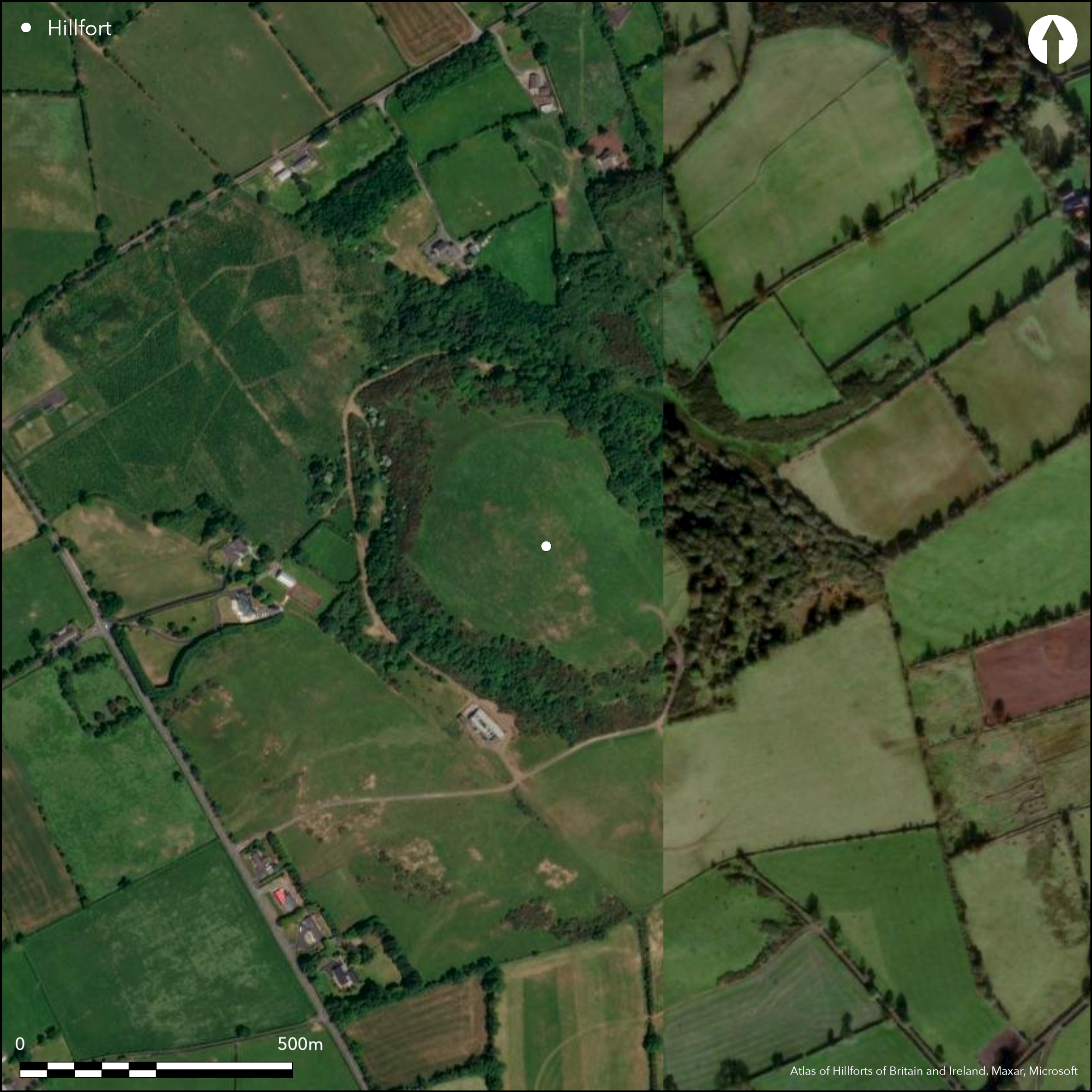
Pear shaped partial contour fort surrounding the domed summit of Lyles Hill, near Belfast city. The site has a total footprint of approximately 6.3ha and is univallate for the entire circuit. There are four breaks in the enclosing elements. Two of these may be original and comprise simple breaks through the bank on the NW and SE. Central cairn visible on the surface, pits, hearths, Neolithic pottery, stone tools, small stone ornaments, Bronze Age food Vessels and urns and two palisaded enclosures were found within the interior (Evans 1953; Gibson and Simpson 1987; Simpson and Gibson 1989). Most of this material dates to an earlier phase before the construction of the hillfort. Ramparts survive well throughout the circuit. Interior is under pasture. Excavations by Evans (1953) and Gibson and Simpson (1987). Late Bronze Age dates for hillfort bank. Intensive Neolithic activity on the hilltop identified. Iron Age reuse of the hillfort.
Citizen Science: ✗
Reliability of Data: Confirmed
Reliability of Interpretation: Confirmed
X: -675305 Y: 7299780 (EPSG: 3857)
Longitude: -6.066372389845712 Latitude: 54.6788200728783 (EPSG:4326)
Country: Northern Ireland; None
Current County or Unitary Authority: Antrim
Historic County: Antrim
Current Parish/Community/Council/Townland: Ballymartin; Ballynabarsish
None
| Extant | ✓ |
| Cropmark | ✗ |
| Likely Destroyed | ✗ |
None
| Woodland | ✗ |
| Commercial Forestry Plantation | ✗ |
| Parkland | ✗ |
| Pasture (Grazing) | ✓ |
| Arable | ✗ |
| Scrub/Bracken | ✗ |
| Bare Outcrop | ✗ |
| Heather/Moorland | ✗ |
| Heath | ✗ |
| Built-up | ✗ |
| Coastal Grassland | ✗ |
| Other | ✗ |
Pear shaped partial contour fort surrounding the domed summit of Lyles Hill. Panoramic views from the summit, with particularly impressive views of low lying land to the N. The enclosing elements follow the contours of the hill from NW-SE and cut across the slope at the S and SW in particular.
| Contour Fort | ✗ |
| Partial Contour Fort | ✓ |
| Promontory Fort | ✗ |
| Hillslope Fort | ✗ |
| Level Terrain Fort | ✗ |
| Marsh Fort | ✗ |
| Multiple Enclosure Fort | ✗ |
| Hilltop | ✓ |
| Coastal Promontory | ✗ |
| Inland Promontory | ✗ |
| Valley Bottom | ✗ |
| Knoll/Hillock/Outcrop | ✗ |
| Ridge | ✗ |
| Cliff/Plateau-edge/Scarp | ✗ |
| Hillslope | ✗ |
| Lowland | ✗ |
| Spur | ✗ |
Dominant Topographic Feature: Lyles Hill.
| North | ✗ |
| Northeast | ✗ |
| East | ✗ |
| Southeast | ✗ |
| South | ✗ |
| Southwest | ✗ |
| West | ✗ |
| Northwest | ✗ |
| Level | ✓ |
Altitude: 219.0m
The NE section of the enclosing elements forms the boundary between Toberagnee and Ballynabarsish townlands.
Boundary Type: Parish/Townland
Two radiocarbon dates from the bank of the hillfort suggest that the hillfort on Lyles Hill was constructed during the Late Bronze Age. Further radiocarbon determinations and artifacts indicate a heavy Neolithic presence associated with two large palisade enclosures within the later hillfort banks (Gibson and Simpson 1987; Simpson and Gibson 1989). Evidence for the re-use of the monument in the Late Iron Age was revealed by radiocarbon dates from the gravel capping of the bank (8 ± 130 BC) and a post-hole driven into the top of the bank (154 ± 55 AD) (Simpson and Gibson 1989, 215).
Reliability: B - Medium
| Pre 1200BC | ✓ |
| 1200BC - 800BC | ✓ |
| 800BC - 400BC | ✗ |
| 400BC - AD50 | ✓ |
| AD50 - AD400 | ✗ |
| AD400 - AD 800 | ✗ |
| Post AD800 | ✗ |
| Unknown | ✗ |
| Pre Hillfort: | None |
| Post Hillfort: | None |
| Artefactual: | None |
| C14: | None |
The hillfort was first identified by aerial photography in 1927 and was later excavated by Evans in 1937, 1938, 1947 and 1951. These excavations concentrated on the central cairn and the hillfort banks. Further excavations by Gibson and Simpson (Gibson and Simpson 1987; Simpson and Gibson 1989) in 1987 excavated another section of the bank and part of the interior.
| Other (1927): | First identified by aerial photography. |
| Excavation (1947): | Evans |
| Excavation (1951): | Evans |
| Excavation (1987): | Gibson and Simpson |
| Excavation (None): | Evans |
The hillfort surrounds a cairn approximately 20m in diameter and less than 1m in height near the summit. The cairn was excavated by Evans (1953) and dated to the Neolithic by lithics and pottery indicative of this period. This material was recovered from 8 pits directly beneath the cairn material (Evans 1953). The excavations uncovered pits, hearths, vast quantities of Neolithic pottery, stone tools and small stone ornaments. Bronze Age food Vessels and urns were also found. Later excavations by Gibson and Simpson (1987) recovered similar material, but linked this earlier phase with two newly discovered palisade enclosures dated to the Neolithic. There is little evidence for intensive Late Bronze Age activity contemporary with the construction of the hillfort.
None
| None | ✓ |
| Spring | ✗ |
| Stream | ✗ |
| Pool | ✗ |
| Flush | ✗ |
| Well | ✗ |
| Other | ✗ |
Cairn
| No Known Features | ✗ |
| Round Stone Structures | ✗ |
| Rectangular Stone Structures | ✗ |
| Curvilinear Platforms | ✗ |
| Other Roundhouse Evidence | ✗ |
| Pits | ✗ |
| Quarry Hollows | ✗ |
| Other | ✓ |
Most of the features recorded within the interior of the hillfort date to an earlier Neolithic phase.
| No Known Excavation | ✗ |
| Pits | ✓ |
| Postholes | ✓ |
| Roundhouses | ✗ |
| Rectangular Structures | ✗ |
| Roads/Tracks | ✗ |
| Quarry Hollows | ✗ |
| Other | ✓ |
| Nothing Found | ✗ |
None
| No Known Geophysics | ✓ |
| Pits | ✗ |
| Roundhouses | ✗ |
| Rectangular Structures | ✗ |
| Roads/Tracks | ✗ |
| Quarry Hollows | ✗ |
| Other | ✗ |
| Nothing Found | ✗ |
All material relating to the Neolithic and earlier Bronze Age occupation
| No Known Finds | ✗ |
| Pottery | ✓ |
| Metal | ✗ |
| Metalworking | ✗ |
| Human Bones | ✓ |
| Animal Bones | ✗ |
| Lithics | ✓ |
| Environmental | ✗ |
| Other | ✗ |
NO APPARENT FEATURES
| APs Not Checked | ✗ |
| None | ✓ |
| Roundhouses | ✗ |
| Rectangular Structures | ✗ |
| Pits | ✗ |
| Postholes | ✗ |
| Roads/Tracks | ✗ |
| Other | ✗ |
Although there are four gaps in the enclosing elements indicated on Gibson and Simpson's (1987, 73) plan of the hillfort, only two may be original. These comprise of opposing simple and narrow gaps in the bank at the SSE and NNW.
| 4: | None |
| 2: | None |
Guard Chambers: ✗
Chevaux de Frise: ✗
| 1. Simple Gap (South east): | None |
| 2. Simple Gap (North west): | None |
This pear shaped univallate enclosure has a total site footprint of 6.25ha. It comprises a bank 9m wide and approximately 1m in height with no apparent ditch feature. Portions of the bank were excavated by Evans (1953). The bank was originally dated to the Neolithic by Evans (1953) due to the exclusively Neolithic material that was mixed within the core. Radiocarbon dates obtained from the bank material (1279 ± 115 BC) and old ground surface (1426 ± 100 BC) have re-dated the construction of the embankment to the Late bronze Age (Gibson and Simpson 1987; Simpson and Gibson 1989), suggesting that the bank material incorporated earlier, residual material. Interestingly, evidence for the re-use of the monument in the Late Iron Age was revealed by radiocarbon dates from the gravel capping of the bank (8 ± 130 BC) and a post-hole driven into the top of the bank (154 ± 55 AD) (Simpson and Gibson, 215).
| Area 1: | 6.11ha. |
| Total: | 6.11ha. |
Total Footprint Area: 6.25ha.
None
| ✗ | None |
| ✓ | None |
| NE Quadrant: | 1 |
| SE Quadrant: | 1 |
| SW Quadrant: | 1 |
| NW Quadrant: | 1 |
| Total: | 1 |
| Partial Univallate | ✗ |
| Univallate | ✓ |
| Partial Bivallate | ✗ |
| Bivallate | ✗ |
| Partial Multivallate | ✗ |
| Multivallate | ✗ |
| Unknown | ✗ |
| Partial Univallate | ✗ |
| Univallate | ✗ |
| Partial Bivallate | ✗ |
| Bivallate | ✗ |
| Partial Multivallate | ✗ |
| Multivallate | ✗ |
None
| None | ✗ |
| Earthen Bank | ✓ |
| Stone Wall | ✗ |
| Rubble | ✗ |
| Wall-walk | ✗ |
| Evidence of Timber | ✗ |
| Vitrification | ✗ |
| Other Burning | ✗ |
| Palisade | ✗ |
| Counter Scarp Bank | ✗ |
| Berm | ✗ |
| Unfinished | ✗ |
| Other | ✗ |
None
| None | ✗ |
| Earthen Bank | ✓ |
| Stone Wall | ✗ |
| Murus Duplex | ✗ |
| Timber-framed | ✗ |
| Timber-laced | ✗ |
| Vitrification | ✗ |
| Other Burning | ✗ |
| Palisade | ✗ |
| Counter Scarp Bank | ✗ |
| Berm | ✗ |
| Unfinished | ✗ |
| No Known Excavation | ✗ |
| Other | ✗ |
| ✗ | None |
| ✗ | No obvious ditch feature recorded. |
Number of Ditches: 0
| ✗ | None. |
Evans, E. 1953. Lyles Hill: a Late Neolithic Site in County Antrim. Stationary Office, Belfast.
Gibson, A. and Simpson, D. 1987. Lyles Hill, Co. Antrim. Archaeology Ireland 1(2), 72-75.
Simpson, D. and Gibson, S. 1989. Lyles Hill. Current Archarology 114, 214-215.
Atlas of Hillforts:
Wikidata:
This work is licensed under CC BY-SA 4.0![]()
![]()
![]() and should be cited as:
and should be cited as:
Lock, Gary and Ralston, Ian. 2024. Atlas of Hillforts of Britain and Ireland. Available at: https://hillforts.arch.ox.ac.uk
Document Version 1.1