Satellite Imagery
Satellite Imagery
HER: Northern Ireland Sites and Monuments Record ANT035:005 (None)
NMR: ANT 035 (None)
SM: ANT35:5
NGR: None
X: 734106 Y: 906636 (IRENET95)
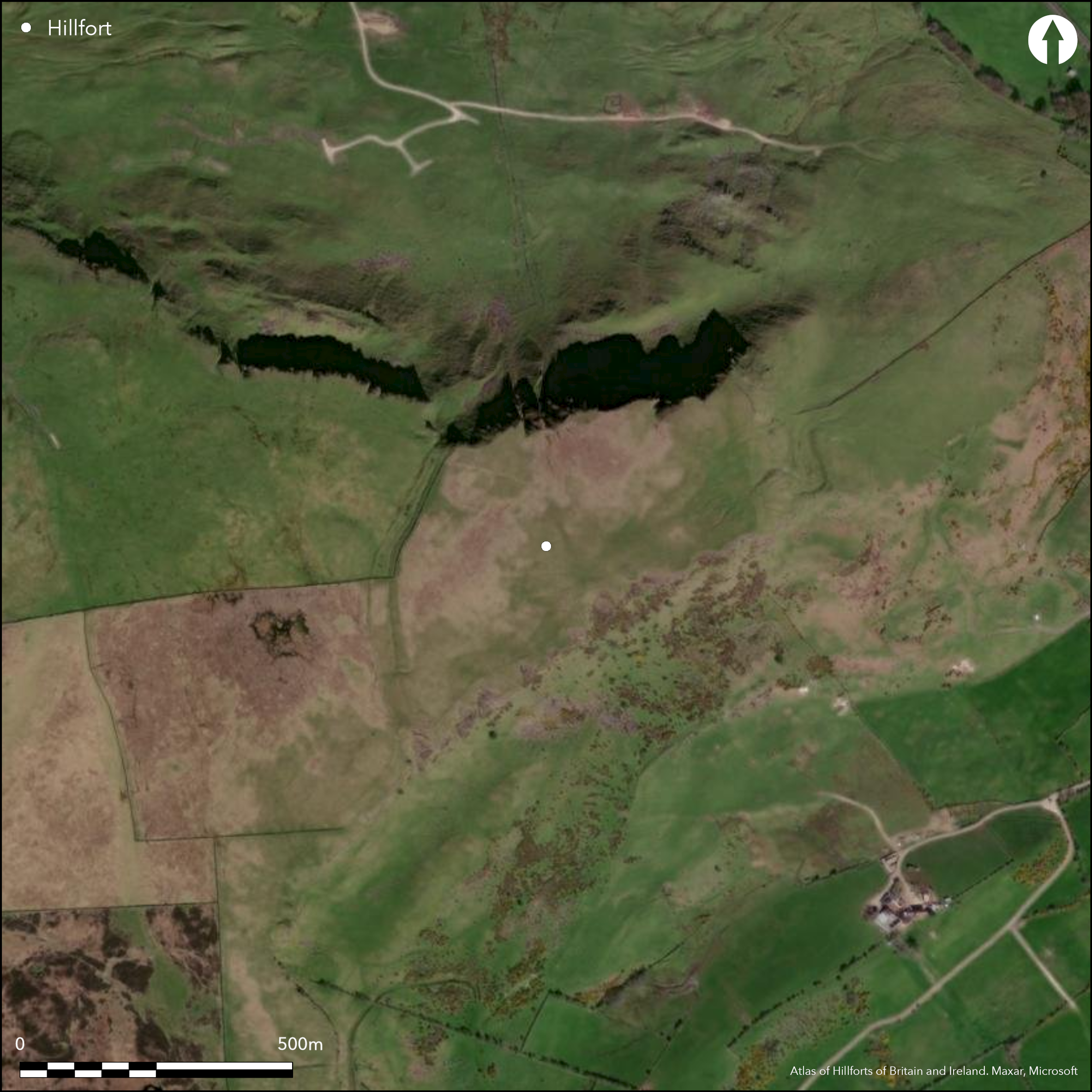
Large multivallate inland promontory fort on E edge of the Antrim plateau. The natural promontory is an impressive and commanding feature in the landscape and affords panoramic views, with particularly impressive views of the Antim coastline and the Irish sea to the E. The western approach is protected using a series of banks and ditches. The inner comprises two banks and a medial ditch; the outer a single bank with traces of an external ditch. The site has a total footprint of approximately 8.2ha. Near the S margin of the promontory the enclosing elements are broken by a gap in both lines, where the banks of the inner return and unite around the terminals of the medial ditch; this is likely to be an original entrance. Evidence of round house structures in the interior confirmed by excavation. Ramparts survive well throughout their length. Excavation of the enclosing elements by Time Team indicate the ditch was partially rock cut and there is evidence for a palisade on one of the banks. The site was dated to the Middle _ Late Bronze Age by radiocarbon dating and flint tool technology (McNeary 2012). LiDAR commissioned by the Built Heritage (Northern Ireland Environmental Agency) in 2012 (McNeary 2012). This added 50 new round house structures to the 18 discovered in 2008 (McNeary 2012).
Citizen Science: ✗
Reliability of Data: Confirmed
Reliability of Interpretation: Confirmed
X: -657855 Y: 7340448 (EPSG: 3857)
Longitude: -5.90960855562728 Latitude: 54.88949021001207 (EPSG:4326)
Country: Northern Ireland; None
Current County or Unitary Authority: Antrim
Historic County: Antrim
Current Parish/Community/Council/Townland: Carncastle; Drain Bog, Linford and Sallagh townlands.
None
| Extant | ✓ |
| Cropmark | ✗ |
| Likely Destroyed | ✗ |
None
| Woodland | ✗ |
| Commercial Forestry Plantation | ✗ |
| Parkland | ✗ |
| Pasture (Grazing) | ✓ |
| Arable | ✗ |
| Scrub/Bracken | ✗ |
| Bare Outcrop | ✗ |
| Heather/Moorland | ✓ |
| Heath | ✗ |
| Built-up | ✗ |
| Coastal Grassland | ✗ |
| Other | ✗ |
Knockdhu hillfort is a large multivallate inland promontory fort. The monument uses cliff edges on the N, E and SE as a natural barrier. The western approach is protected using a series of three bank and ditch earthworks. The natural promontory is an impressive and commanding feature in the landscape and affords panoramic views, with particularly impressive views of the Antim coastline and the Irish sea to the E.
| Contour Fort | ✗ |
| Partial Contour Fort | ✗ |
| Promontory Fort | ✓ |
| Hillslope Fort | ✗ |
| Level Terrain Fort | ✗ |
| Marsh Fort | ✗ |
| Multiple Enclosure Fort | ✗ |
| Hilltop | ✓ |
| Coastal Promontory | ✗ |
| Inland Promontory | ✓ |
| Valley Bottom | ✗ |
| Knoll/Hillock/Outcrop | ✗ |
| Ridge | ✗ |
| Cliff/Plateau-edge/Scarp | ✗ |
| Hillslope | ✗ |
| Lowland | ✗ |
| Spur | ✗ |
Dominant Topographic Feature: Knockdhu promontory.
| North | ✗ |
| Northeast | ✗ |
| East | ✗ |
| Southeast | ✗ |
| South | ✗ |
| Southwest | ✗ |
| West | ✗ |
| Northwest | ✗ |
| Level | ✓ |
Altitude: 362.0m
The steep break of slope defining this inland promontory fort forms the boundaries between Ballyhackett, Drain Bog, Linford and Sallagh townlands.
Boundary Type: Parish/Townland
The site was dated to the Middle _ Late Bronze Age by radiocarbon dating and flint tool technology (McNeary 2012).
Reliability: B - Medium
| Pre 1200BC | ✓ |
| 1200BC - 800BC | ✓ |
| 800BC - 400BC | ✗ |
| 400BC - AD50 | ✗ |
| AD50 - AD400 | ✗ |
| AD400 - AD 800 | ✗ |
| Post AD800 | ✗ |
| Unknown | ✗ |
| Pre Hillfort: | None |
| Post Hillfort: | None |
| Artefactual: | Flintwork |
| C14: | None |
Excavation of the site in 2008 as part of the Time Team television series. LiDAR commissioned by the Built Heritage (Northern Ireland Environmental Agency) in 2012 (McNeary 2012).
| Excavation (2008): | Time Team. |
| LiDAR Survey (2012): | (McNeary 2012). |
Four round-houses were excavated in 2008 as part of the Time Team television series. Recent high-resolution LiDAR commissioned by the Built Heritage (Northern Ireland Environmental Agency), has provided further evidence for internal occupation on site. This has added up to 50 new round-house structures to the 18 discovered in 2008 (McNeary 2012).
None
| None | ✓ |
| Spring | ✗ |
| Stream | ✗ |
| Pool | ✗ |
| Flush | ✗ |
| Well | ✗ |
| Other | ✗ |
None
| No Known Features | ✗ |
| Round Stone Structures | ✗ |
| Rectangular Stone Structures | ✗ |
| Curvilinear Platforms | ✓ |
| Other Roundhouse Evidence | ✗ |
| Pits | ✗ |
| Quarry Hollows | ✗ |
| Other | ✗ |
None
| No Known Excavation | ✗ |
| Pits | ✗ |
| Postholes | ✗ |
| Roundhouses | ✓ |
| Rectangular Structures | ✗ |
| Roads/Tracks | ✗ |
| Quarry Hollows | ✗ |
| Other | ✗ |
| Nothing Found | ✗ |
None
| No Known Geophysics | ✓ |
| Pits | ✗ |
| Roundhouses | ✗ |
| Rectangular Structures | ✗ |
| Roads/Tracks | ✗ |
| Quarry Hollows | ✗ |
| Other | ✗ |
| Nothing Found | ✗ |
None
| No Known Finds | ✗ |
| Pottery | ✗ |
| Metal | ✗ |
| Metalworking | ✗ |
| Human Bones | ✗ |
| Animal Bones | ✗ |
| Lithics | ✓ |
| Environmental | ✗ |
| Other | ✗ |
None
| APs Not Checked | ✗ |
| None | ✗ |
| Roundhouses | ✓ |
| Rectangular Structures | ✗ |
| Pits | ✗ |
| Postholes | ✗ |
| Roads/Tracks | ✗ |
| Other | ✗ |
Near the S edge of the enclosing elements, a simple gap in both the inner and outer banks is likely to be an original entrance.
| 1: | None |
| 2: | None |
Guard Chambers: ✗
Chevaux de Frise: ✗
| 1. Passage-way/Corridor (South west): | The banks of the inner line return and unite around the terminals of the inner ditch |
The monument uses cliff edges to the north, east and south-east as a natural barrier. The western approach is protected using a series of three bank and ditch earthworks. A section through the enclosing elements was excavated in 2008 as part of the Time Team television series. The site was dated to the Middle _ Late Bronze Age by radiocarbon dating and flint tool technology (McNeary 2012). Excavation of the enclosing elements indicate one ditch was partially rock cut and there is evidence for a palisade on one of the banks.
| Area 1: | 7.86ha. |
| Total: | 7.86ha. |
Total Footprint Area: 8.21ha.
None
| ✗ | None |
| ✗ | The ramparts cut of an impressive natural inland promontory. |
| NE Quadrant: | 0 |
| SE Quadrant: | 0 |
| SW Quadrant: | 3 |
| NW Quadrant: | 3 |
| Total: | 3 |
| Partial Univallate | ✗ |
| Univallate | ✗ |
| Partial Bivallate | ✗ |
| Bivallate | ✗ |
| Partial Multivallate | ✓ |
| Multivallate | ✗ |
| Unknown | ✗ |
| Partial Univallate | ✗ |
| Univallate | ✗ |
| Partial Bivallate | ✗ |
| Bivallate | ✗ |
| Partial Multivallate | ✗ |
| Multivallate | ✗ |
None
| None | ✗ |
| Earthen Bank | ✓ |
| Stone Wall | ✗ |
| Rubble | ✗ |
| Wall-walk | ✗ |
| Evidence of Timber | ✗ |
| Vitrification | ✗ |
| Other Burning | ✗ |
| Palisade | ✗ |
| Counter Scarp Bank | ✗ |
| Berm | ✗ |
| Unfinished | ✗ |
| Other | ✗ |
Earthen bank and partially rock-cut ditch.
| None | ✗ |
| Earthen Bank | ✓ |
| Stone Wall | ✗ |
| Murus Duplex | ✗ |
| Timber-framed | ✗ |
| Timber-laced | ✗ |
| Vitrification | ✗ |
| Other Burning | ✗ |
| Palisade | ✓ |
| Counter Scarp Bank | ✗ |
| Berm | ✗ |
| Unfinished | ✗ |
| No Known Excavation | ✗ |
| Other | ✓ |
| ✗ | None |
| ✓ | External ditches. |
Number of Ditches: 2
| ✗ | None. |
McNeary, R. 2012. Archaeological applications of airborne LiDAR in Northern Ireland, Case study: Knockdhu, Co. Antrim. https://www.archaeolandscapes.eu/index.php/ro/studii-de-caz/lidar/228.html.
Atlas of Hillforts:
Wikidata:
This work is licensed under CC BY-SA 4.0![]()
![]()
![]() and should be cited as:
and should be cited as:
Lock, Gary and Ralston, Ian. 2024. Atlas of Hillforts of Britain and Ireland. Available at: https://hillforts.arch.ox.ac.uk
Document Version 1.1