Satellite Imagery
Satellite Imagery
HER: Northern Ireland Sites and Monuments Record ANT020:008 (None)
NMR: ANT 020 (None)
SM: ANT 20:8
NGR: None
X: 722630 Y: 925529 (IRENET95)
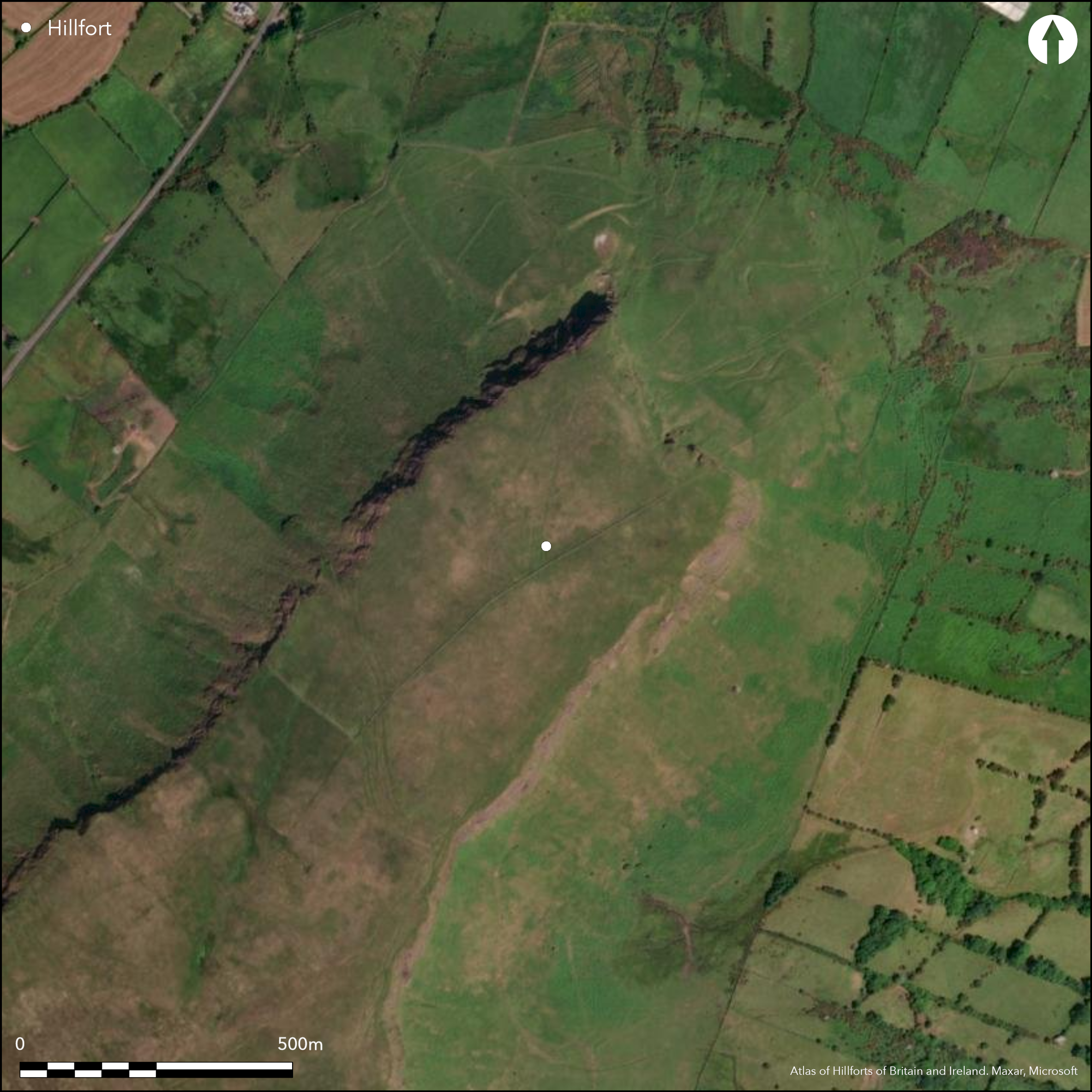
Lurigethan hillfort is a large multivallate inland-promontory fort. The natural promontory is an impressive and commanding feature in the landscape and affords panoramic views, with particularly impressive views of the Antrim coastline and the Irish sea to the E. The site has a total footprint of approximately 9.7ha. Up to six banks and five ditches are visible, blocking the approach from the SW, and although the banks appear to merge into one another in the northern sector, at least four are visible throughout. There is a break through the enclosing elements on the SW near the southern end of the defences, comprising a simple gap; this is probably an original entrance. No evidence for any internal features noted on the surface, but possible round house structures are apparent in aerial photography. Ramparts survive well throughout their length. Monument survey in 1940 (Chart 1940).
Citizen Science: ✗
Reliability of Data: Confirmed
Reliability of Interpretation: Confirmed
X: -676856 Y: 7373925 (EPSG: 3857)
Longitude: -6.080296980130459 Latitude: 55.06208420109906 (EPSG:4326)
Country: Northern Ireland; None
Current County or Unitary Authority: Antrim
Historic County: Antrim
Current Parish/Community/Council/Townland: Layd; Foriff, Knockans North, Knockans South, Red Bay, Cortaleean and Ballynalougher
None
| Extant | ✓ |
| Cropmark | ✗ |
| Likely Destroyed | ✗ |
None
| Woodland | ✗ |
| Commercial Forestry Plantation | ✗ |
| Parkland | ✗ |
| Pasture (Grazing) | ✓ |
| Arable | ✗ |
| Scrub/Bracken | ✗ |
| Bare Outcrop | ✗ |
| Heather/Moorland | ✓ |
| Heath | ✗ |
| Built-up | ✗ |
| Coastal Grassland | ✗ |
| Other | ✗ |
Lurigethan hillfort is a large multivallate inland promontory fort. The monument uses cliff edges to the NW, NE and SE as a natural barrier. The SW approach is protected using a series of up to six banks and ditches. The natural promontory is an impressive and commanding feature in the landscape and affords panoramic views, with particularly impressive views of the Antim coastline and the Irish sea to the E.
| Contour Fort | ✗ |
| Partial Contour Fort | ✗ |
| Promontory Fort | ✓ |
| Hillslope Fort | ✗ |
| Level Terrain Fort | ✗ |
| Marsh Fort | ✗ |
| Multiple Enclosure Fort | ✗ |
| Hilltop | ✓ |
| Coastal Promontory | ✗ |
| Inland Promontory | ✓ |
| Valley Bottom | ✗ |
| Knoll/Hillock/Outcrop | ✗ |
| Ridge | ✗ |
| Cliff/Plateau-edge/Scarp | ✗ |
| Hillslope | ✗ |
| Lowland | ✗ |
| Spur | ✗ |
Dominant Topographic Feature: Lurigethan promontory.
| North | ✗ |
| Northeast | ✗ |
| East | ✗ |
| Southeast | ✗ |
| South | ✗ |
| Southwest | ✗ |
| West | ✗ |
| Northwest | ✗ |
| Level | ✓ |
Altitude: 343.0m
The townlands of Foriff, Knockans North, Knockans South, Red Bay, Cortaleean and Ballynalougher intersect at the center of the hillfort.
Boundary Type: Parish/Townland
No dating evidence.
Reliability: D - None
| Pre 1200BC | ✗ |
| 1200BC - 800BC | ✗ |
| 800BC - 400BC | ✗ |
| 400BC - AD50 | ✗ |
| AD50 - AD400 | ✗ |
| AD400 - AD 800 | ✗ |
| Post AD800 | ✗ |
| Unknown | ✓ |
| Pre Hillfort: | None |
| Post Hillfort: | None |
Monument survey in 1940 (Chart 1940, 20).
| Other (1940): | Chart |
| Other (1992): | Visit by Northern Irish Survey |
Hut structures visible in aerial photography at the NE edge of the interior.
None
| None | ✓ |
| Spring | ✗ |
| Stream | ✗ |
| Pool | ✗ |
| Flush | ✗ |
| Well | ✗ |
| Other | ✗ |
None
| No Known Features | ✓ |
| Round Stone Structures | ✗ |
| Rectangular Stone Structures | ✗ |
| Curvilinear Platforms | ✗ |
| Other Roundhouse Evidence | ✗ |
| Pits | ✗ |
| Quarry Hollows | ✗ |
| Other | ✗ |
None
| No Known Excavation | ✓ |
| Pits | ✗ |
| Postholes | ✗ |
| Roundhouses | ✗ |
| Rectangular Structures | ✗ |
| Roads/Tracks | ✗ |
| Quarry Hollows | ✗ |
| Other | ✗ |
| Nothing Found | ✗ |
None
| No Known Geophysics | ✓ |
| Pits | ✗ |
| Roundhouses | ✗ |
| Rectangular Structures | ✗ |
| Roads/Tracks | ✗ |
| Quarry Hollows | ✗ |
| Other | ✗ |
| Nothing Found | ✗ |
None
| No Known Finds | ✓ |
| Pottery | ✗ |
| Metal | ✗ |
| Metalworking | ✗ |
| Human Bones | ✗ |
| Animal Bones | ✗ |
| Lithics | ✗ |
| Environmental | ✗ |
| Other | ✗ |
Possible round houses.
| APs Not Checked | ✗ |
| None | ✗ |
| Roundhouses | ✓ |
| Rectangular Structures | ✗ |
| Pits | ✗ |
| Postholes | ✗ |
| Roads/Tracks | ✗ |
| Other | ✗ |
Break through the enclosing elements at the S, comprising a simple gap.
| 1: | None |
| 2: | None |
Guard Chambers: ✗
Chevaux de Frise: ✗
| 1. Simple Gap (South west): | None |
Up to six banks and five ditches are visible in places. The banks appear to merge into one another in places, particularly towards the N, though at least four banks can be seen in this sector. The innermost bank may be stone faced and is a maximum of 3.5m wide and 1.9m high. The second bank is 1.3m in maximum width and 0.8m high. The third bank is a maximum of 1.4m high and 0.8m wide. The fourth bank is 0.7m in maximum height. The fifth bank is 0.6m in maximum height and 1.4m wide. The outermost bank is 0.7m in maximum height (Chart 1940, 20).
| Area 1: | 9.57ha. |
| Total: | 9.57ha. |
Total Footprint Area: 9.74ha.
None
| ✗ | None |
| ✗ | The ramparts cut off an impressive natural inland promontory. |
| NE Quadrant: | 0 |
| SE Quadrant: | 0 |
| SW Quadrant: | 6 |
| NW Quadrant: | 0 |
| Total: | 6 |
| Partial Univallate | ✗ |
| Univallate | ✗ |
| Partial Bivallate | ✗ |
| Bivallate | ✗ |
| Partial Multivallate | ✓ |
| Multivallate | ✗ |
| Unknown | ✗ |
| Partial Univallate | ✗ |
| Univallate | ✗ |
| Partial Bivallate | ✗ |
| Bivallate | ✗ |
| Partial Multivallate | ✗ |
| Multivallate | ✗ |
None
| None | ✗ |
| Earthen Bank | ✓ |
| Stone Wall | ✗ |
| Rubble | ✗ |
| Wall-walk | ✗ |
| Evidence of Timber | ✗ |
| Vitrification | ✗ |
| Other Burning | ✗ |
| Palisade | ✗ |
| Counter Scarp Bank | ✗ |
| Berm | ✗ |
| Unfinished | ✗ |
| Other | ✗ |
None
| None | ✗ |
| Earthen Bank | ✗ |
| Stone Wall | ✗ |
| Murus Duplex | ✗ |
| Timber-framed | ✗ |
| Timber-laced | ✗ |
| Vitrification | ✗ |
| Other Burning | ✗ |
| Palisade | ✗ |
| Counter Scarp Bank | ✗ |
| Berm | ✗ |
| Unfinished | ✗ |
| No Known Excavation | ✓ |
| Other | ✗ |
| ✗ | None |
| ✓ | None |
Number of Ditches: 5
| ✗ | None. |
Chart, D. 1940. A Preliminary Survey of the Ancient Monuments of Northern Ireland. H.M. Stationery office, Belfast.
Atlas of Hillforts:
Wikidata:
This work is licensed under CC BY-SA 4.0![]()
![]()
![]() and should be cited as:
and should be cited as:
Lock, Gary and Ralston, Ian. 2024. Atlas of Hillforts of Britain and Ireland. Available at: https://hillforts.arch.ox.ac.uk
Document Version 1.1