Satellite Imagery
Satellite Imagery
HER: Northern Ireland Sites and Monuments Record DOW037:027 (None)
NMR: DOW 037 (None)
SM: DOW 37:27
NGR: None
X: 748127 Y: 844471 (IRENET95)
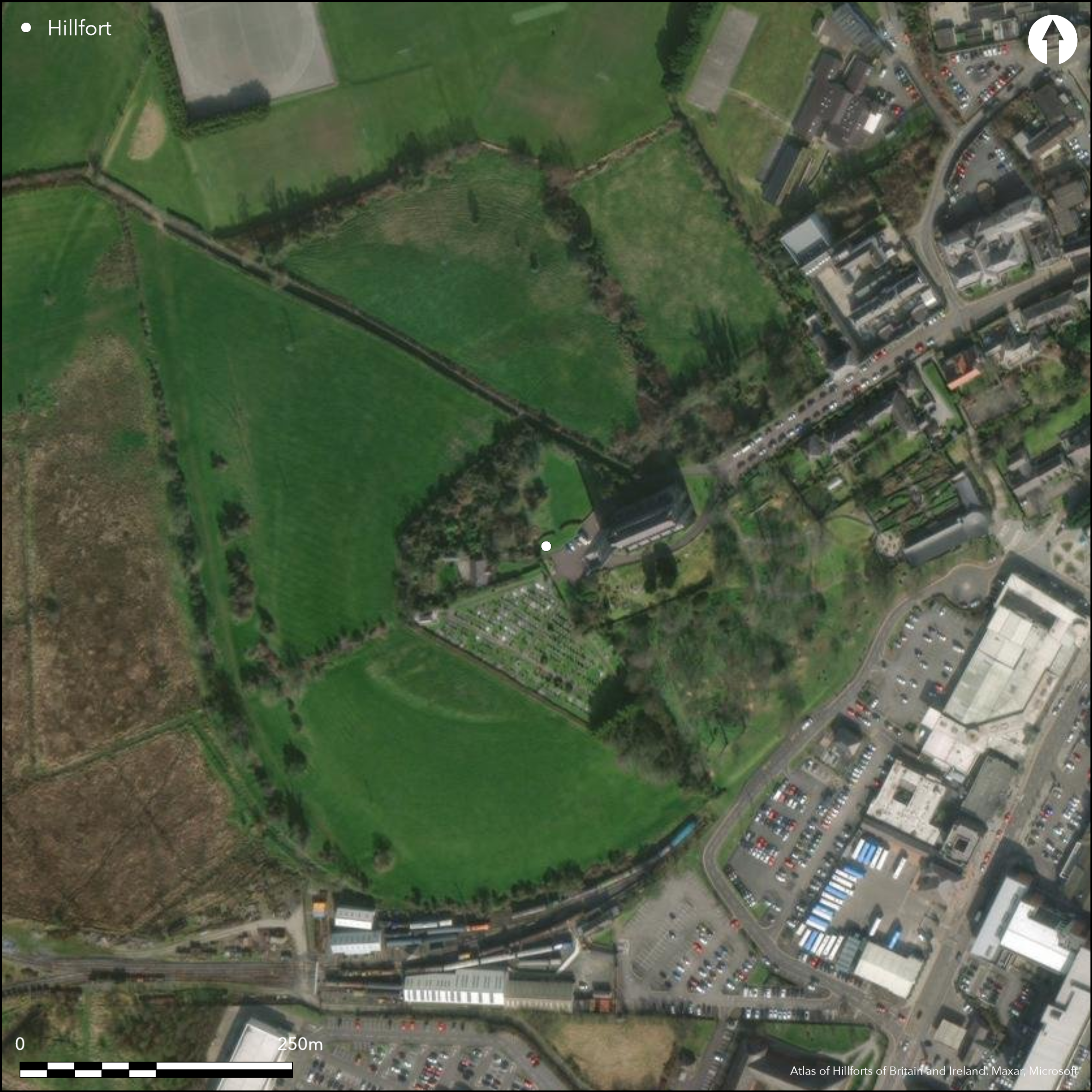
Contour fort located in commanding position surrounding summit of Downpatrick Hill, with panoramic views from the summit. Visible as a vegetation mark in aerial photography. No obvious entrance features recorded. The hillfort is truncated by a large church and car park at the summit. Three Late Bronze Age gold hoards from the interior of the hillfort attest to Late Bronze Age activity. An excavated oval structure may be broadly contemporary with the initial construction and occupation of the hillfort. This structure has been truncated by later features and coarse pottery was found in close proximity of the site (Proudfoot 1954, 97 _ 99). More than a dozen clay or wattle and daub lined pits of varying size were excavated in the interior. Excavations by Proudfoot (1954 and 1955). Trial excavation by Hamlin and Lynn (1988). No radiocarbon dates. Artifactual evidence dates the site to the Late Bronze Age. Substantial evidence for reuse of the site during the Early Medieval and High Medieval period.
Citizen Science: ✗
Reliability of Data: Confirmed
Reliability of Interpretation: Confirmed
X: -637040 Y: 7232413 (EPSG: 3857)
Longitude: -5.72262679033466 Latitude: 54.32742827991677 (EPSG:4326)
Country: Northern Ireland
Current County or Unitary Authority: Down
Historic County: Down
Current Parish/Community/Council/Townland: Downwpatrick
The entire monument has been levelled and is visible as a vegetation mark.
| Extant | ✗ |
| Cropmark | ✗ |
| Likely Destroyed | ✓ |
None
| Woodland | ✗ |
| Commercial Forestry Plantation | ✗ |
| Parkland | ✗ |
| Pasture (Grazing) | ✓ |
| Arable | ✗ |
| Scrub/Bracken | ✗ |
| Bare Outcrop | ✗ |
| Heather/Moorland | ✗ |
| Heath | ✗ |
| Built-up | ✓ |
| Coastal Grassland | ✗ |
| Other | ✗ |
Contour fort located in commanding position surrounding summit of Downpatrick Hill, with panoramic views from the summit.
| Contour Fort | ✓ |
| Partial Contour Fort | ✗ |
| Promontory Fort | ✗ |
| Hillslope Fort | ✗ |
| Level Terrain Fort | ✗ |
| Marsh Fort | ✗ |
| Multiple Enclosure Fort | ✗ |
| Hilltop | ✓ |
| Coastal Promontory | ✗ |
| Inland Promontory | ✗ |
| Valley Bottom | ✗ |
| Knoll/Hillock/Outcrop | ✗ |
| Ridge | ✗ |
| Cliff/Plateau-edge/Scarp | ✗ |
| Hillslope | ✗ |
| Lowland | ✗ |
| Spur | ✗ |
Dominant Topographic Feature: Downpatrick Hill
| North | ✗ |
| Northeast | ✗ |
| East | ✗ |
| Southeast | ✗ |
| South | ✗ |
| Southwest | ✗ |
| West | ✗ |
| Northwest | ✗ |
| Level | ✓ |
Altitude: 21.0m
N/A
Excavations produced coarse ware from the ditch fill and underneath the hillfort bank (Proudfoot 1954; 1955). Proudfoot (1954) suggests that these sherds are similar to the Late Bronze Age pottery from crannogs at Ballinderry 2, Knocknalappa and Lough Gara. Raftery (1969, 93_94) describes the Downpatrick and Freestone Hill pottery assemblages as Çsuperficially comparable and later (Raftery 1976, 351) dated the hillfort to the Late Bronze Age. Intensive occupation of the hilltop in the Early and High Medieval periods saw the refurbishment of the enclosing elements (Proudfoot 1954, 100). Later trial excavations have led Hamlin and Lynn (1988, 61_64) to suggest that the hillfort is Early Medieval. However, this disregards clear evidence for the re-use of the enclosure in later periods and does not clearly explain the presence of Late Bronze Age pottery directly underneath the bank and in the ditch fill. While no radiocarbon dates are available, the site may be typologically dated to the Late Bronze Age, although intensive occupation of the hilltop during the Early Medieval period may have disturbed these earlier deposits. Three Late Bronze Age hoards found on the hilltop, two of which were found within the hillfort and a possible third of unknown provenance, further attests to activity in the hillfort during this period (Proudfoot 1957; Proudfoot 1955).
Reliability: C - Low
| Pre 1200BC | ✗ |
| 1200BC - 800BC | ✓ |
| 800BC - 400BC | ✗ |
| 400BC - AD50 | ✗ |
| AD50 - AD400 | ✗ |
| AD400 - AD 800 | ✗ |
| Post AD800 | ✓ |
| Unknown | ✗ |
| Pre Hillfort: | None |
| Post Hillfort: | None |
| Artefactual: | None |
Excavations by Proudfoot (1954 and 1955). Trial excavation by Hamlin and Lynn (1988).
| Excavation (1954): | Proudfoot |
| Excavation (1955): | Proudfoot |
| Excavation (1988): | Hamlin and Lynn |
Three Late Bronze Age gold hoards from the interior of the hillfort attesting to Late Bronze Age activity. An excavated oval structure may be broadly contemporary with the initial construction and occupation of the hillfort. This structure has been truncated by later features and coarse pottery was found in close proximity of the site (Proudfoot 1954, 97 _ 99). More than a dozen clay or wattle and daub lined pits of varying size were excavated in the interior and Proudfoot has identified Late Bronze Age comparisons for these at Minnis Bay and Ballinderry crannog (Proudfoot 1954, 98).
None
| None | ✓ |
| Spring | ✗ |
| Stream | ✗ |
| Pool | ✗ |
| Flush | ✗ |
| Well | ✗ |
| Other | ✗ |
None
| No Known Features | ✓ |
| Round Stone Structures | ✗ |
| Rectangular Stone Structures | ✗ |
| Curvilinear Platforms | ✗ |
| Other Roundhouse Evidence | ✗ |
| Pits | ✗ |
| Quarry Hollows | ✗ |
| Other | ✗ |
None
| No Known Excavation | ✗ |
| Pits | ✓ |
| Postholes | ✓ |
| Roundhouses | ✓ |
| Rectangular Structures | ✗ |
| Roads/Tracks | ✗ |
| Quarry Hollows | ✗ |
| Other | ✗ |
| Nothing Found | ✗ |
None
| No Known Geophysics | ✓ |
| Pits | ✗ |
| Roundhouses | ✗ |
| Rectangular Structures | ✗ |
| Roads/Tracks | ✗ |
| Quarry Hollows | ✗ |
| Other | ✗ |
| Nothing Found | ✗ |
Late Bronze Age coarse ware pottery discovered within the fill of the enclosing elements. Three Late bronze Age gold hoards discovered within the interior of the hillfort.
| No Known Finds | ✗ |
| Pottery | ✓ |
| Metal | ✓ |
| Metalworking | ✗ |
| Human Bones | ✗ |
| Animal Bones | ✗ |
| Lithics | ✗ |
| Environmental | ✗ |
| Other | ✗ |
NO APPARENT FEATURES
| APs Not Checked | ✗ |
| None | ✓ |
| Roundhouses | ✗ |
| Rectangular Structures | ✗ |
| Pits | ✗ |
| Postholes | ✗ |
| Roads/Tracks | ✗ |
| Other | ✗ |
No obvious entrance features recorded.
| 0: | None |
| 2: | None |
Guard Chambers: ✗
Chevaux de Frise: ✗
Univallate contour fort with bank and external ditch visible in aerial photography. Excavations produced coarse ware from the ditch fill and underneath the hillfort bank (Proudfoot 1954; 1955). Proudfoot (1954) suggests that these sherds are similar to the Late Bronze Age pottery from crannogs at Ballinderry 2, Knocknalappa and Lough Gara. Raftery (1969, 93_94) describes the Downpatrick and Freestone Hill pottery assemblages as «superficially comparable and later (Raftery 1976, 351) dated the hillfort to the Late Bronze Age. Intensive occupation of the hilltop in the Early and High Medieval periods saw the refurbishment of the enclosing elements (Proudfoot 1954, 100). Upon excavation the enclosing elements were shown to comprise a ditch-bank-ditch arrangement, although several phases of construction were noted by Proudfoot (1954, 97_98), potentially ranging from the Late Bronze Age to Medieval periods. Upon excavation, the inner ditch measured 3.3m wide and almost 2.4m deep (Proudfoot 1954, 100). Proudfoot (1955, 66) suggests that the inner ditch is of slightly later date, and that the bank and outer ditch are contemporary. A small counterscarp bank was also noted on the outside of the ditch. A series of post-holes at the edge of the exterior bank face, suggest a palisade was used to contain an earthen bank (Proudfoot 1954, 98 _ 99). No charcoal was present inferring the palisade had decayed in-situ. Further excavations revealed that a similar setting of post-holes abutting the inner face of the bank was linked to the outer example by a series of shallow transverse trenches which have been interpreted as the bedding trenches for tie-beams (Proudfoot 1955a, 59), although this seems to be a later «re-furbishment of the enclosing elements and not an original feature. Further tie-beams may have been used throughout the height of the bank, but have been destroyed by its erosion (Proudfoot 1955, 59).
| Area 1: | 2.4ha. |
| Total: | 2.4ha. |
Total Footprint Area: Noneha.
None
| ✗ | Estimated area based on traces visible on satellite imagery and Proudfoot (1954, fig2) |
| ✓ | None |
| NE Quadrant: | 1 |
| SE Quadrant: | 1 |
| SW Quadrant: | 1 |
| NW Quadrant: | 1 |
| Total: | 1 |
| Partial Univallate | ✗ |
| Univallate | ✓ |
| Partial Bivallate | ✗ |
| Bivallate | ✗ |
| Partial Multivallate | ✗ |
| Multivallate | ✗ |
| Unknown | ✗ |
| Partial Univallate | ✗ |
| Univallate | ✗ |
| Partial Bivallate | ✗ |
| Bivallate | ✗ |
| Partial Multivallate | ✗ |
| Multivallate | ✗ |
None
| None | ✓ |
| Earthen Bank | ✗ |
| Stone Wall | ✗ |
| Rubble | ✗ |
| Wall-walk | ✗ |
| Evidence of Timber | ✗ |
| Vitrification | ✗ |
| Other Burning | ✗ |
| Palisade | ✗ |
| Counter Scarp Bank | ✗ |
| Berm | ✗ |
| Unfinished | ✗ |
| Other | ✗ |
And ditches
| None | ✗ |
| Earthen Bank | ✓ |
| Stone Wall | ✗ |
| Murus Duplex | ✗ |
| Timber-framed | ✗ |
| Timber-laced | ✗ |
| Vitrification | ✗ |
| Other Burning | ✗ |
| Palisade | ✗ |
| Counter Scarp Bank | ✗ |
| Berm | ✗ |
| Unfinished | ✗ |
| No Known Excavation | ✗ |
| Other | ✓ |
| ✗ | None |
| ✓ | Internal and external ditch with intervening bank. |
Number of Ditches: 2
| ✗ | None. |
Proudfoot, B. 1954. Excavations at the Cathedral Hill, Downpatrick, Co. Down, 1953. Ulster Journal of Archaeology 17, 9-102.
Proudfoot, B. 1955. Excavations at Cathedral Hill, Downpatrick, Co. Down: preliminary report on excavations in 1954. Ulster Journal of Archaeology 18, 57-72.
Hamlin, A. and Lynn, C. 1988. Archaeological Excavations by the Department of the Environment for Northern Ireland 1970-1986. Crown, Belfast.
Atlas of Hillforts:
Wikidata:
This work is licensed under CC BY-SA 4.0![]()
![]()
![]() and should be cited as:
and should be cited as:
Lock, Gary and Ralston, Ian. 2024. Atlas of Hillforts of Britain and Ireland. Available at: https://hillforts.arch.ox.ac.uk
Document Version 1.1