LiDAR 1m DTM Hillshade
Satellite Imagery
LiDAR 1m DTM Hillshade
Satellite Imagery
Scroll left/right to view further images.
HER: Dumfries & Galloway MDG482 (None)
NMR: NW 95 NE 1 (60312)
SM: 1992
NGR: NW 9754 5983
X: 197540 Y: 559830 (OSGB36)
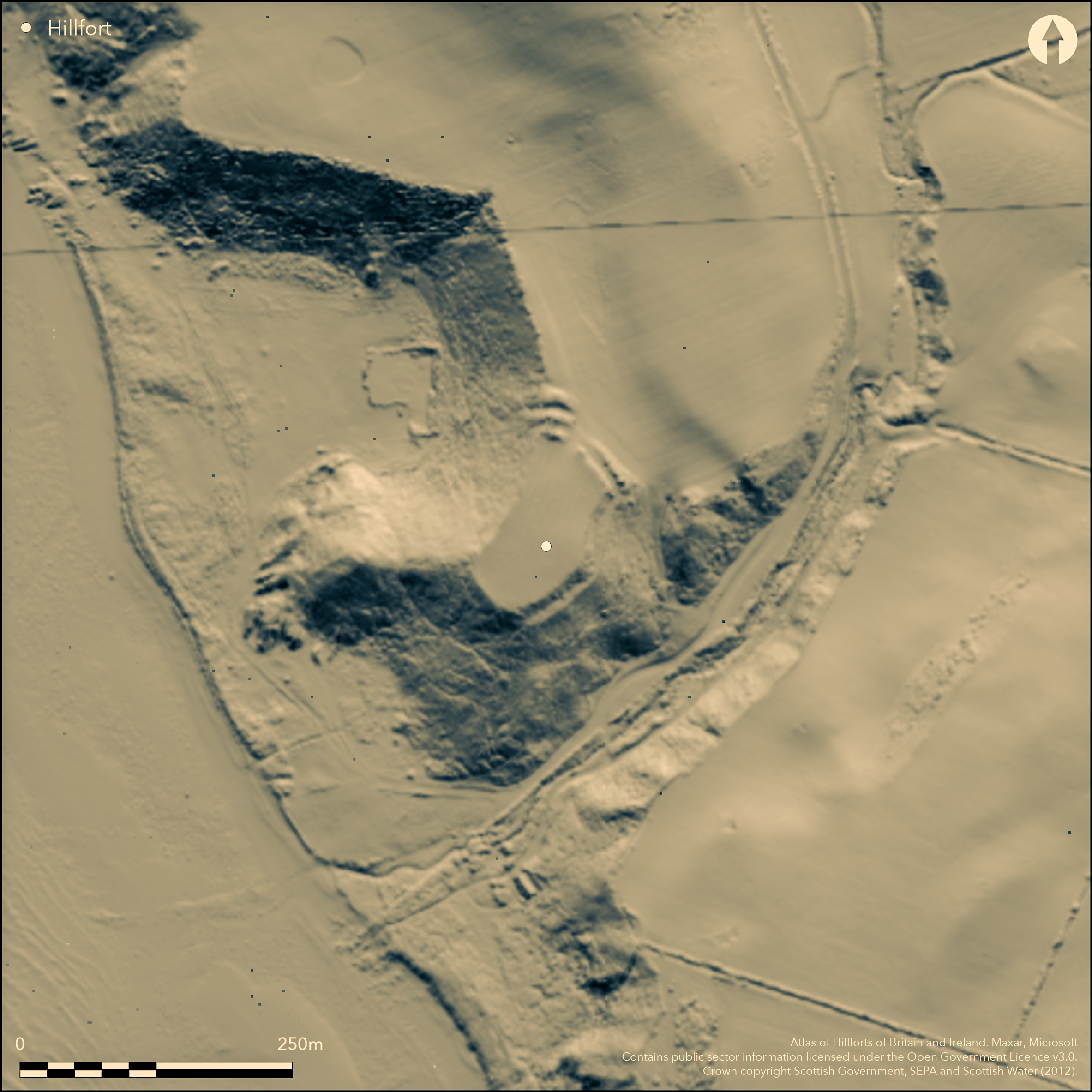
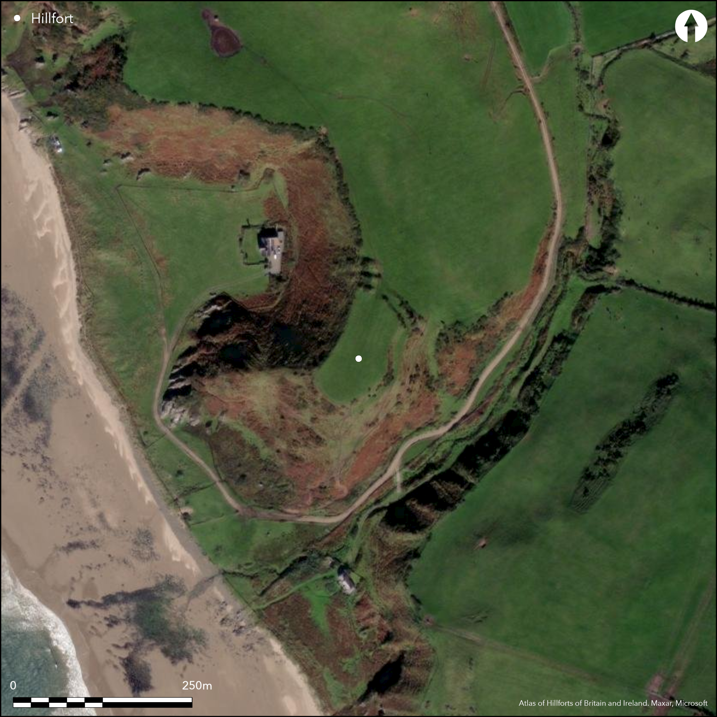
This fort is situated on a promontory on a degraded coastal escarpment set back from the beach in Larbrax Bay. Its defences comprise up to three ramparts and ditches, which cut across the neck of the promontory on the NNE immediately NW of the entrance; SE of the entrance, however, only two ramparts with a medial ditch can be seen, while extending along the SE flank of the promontory these reduce to only a single rampart forming little more than a scarp above a broad level terrace cut into the slope. The interior measures 83m from NE to SW by 44m transversely, but apart from traces of rig and furrow it is featureless.
Citizen Science: ✗
Reliability of Data: Confirmed
Reliability of Interpretation: Confirmed
X: -574249 Y: 7340954 (EPSG: 3857)
Longitude: -5.158566722753074 Latitude: 54.8921052807877 (EPSG:4326)
Country: Scotland
Current County or Unitary Authority: Dumfries & Galloway
Historic County: Wigtownshire
Current Parish/Community/Council/Townland: Leswalt
While in relatively good condition, the outer ramparts have been damaged by cultivation, and there are traces of rig crossing the interior
| Extant | ✓ |
| Cropmark | ✗ |
| Likely Destroyed | ✗ |
Bracken clothes the sides of the promontory and there are scattered gorse bushes on the ramparts
| Woodland | ✗ |
| Commercial Forestry Plantation | ✗ |
| Parkland | ✗ |
| Pasture (Grazing) | ✓ |
| Arable | ✗ |
| Scrub/Bracken | ✓ |
| Bare Outcrop | ✗ |
| Heather/Moorland | ✗ |
| Heath | ✗ |
| Built-up | ✗ |
| Coastal Grassland | ✗ |
| Other | ✗ |
A large promontory on the coastal escarpment overlooking the beach in Larbrax Bay
| Contour Fort | ✗ |
| Partial Contour Fort | ✗ |
| Promontory Fort | ✓ |
| Hillslope Fort | ✗ |
| Level Terrain Fort | ✗ |
| Marsh Fort | ✗ |
| Multiple Enclosure Fort | ✗ |
| Hilltop | ✗ |
| Coastal Promontory | ✓ |
| Inland Promontory | ✗ |
| Valley Bottom | ✗ |
| Knoll/Hillock/Outcrop | ✗ |
| Ridge | ✗ |
| Cliff/Plateau-edge/Scarp | ✗ |
| Hillslope | ✗ |
| Lowland | ✗ |
| Spur | ✗ |
Dominant Topographic Feature: None
| North | ✗ |
| Northeast | ✗ |
| East | ✗ |
| Southeast | ✗ |
| South | ✗ |
| Southwest | ✗ |
| West | ✗ |
| Northwest | ✗ |
| Level | ✓ |
Altitude: 40.0m
N/A
In the absence of excavation, there are neither stratified artefacts nor radiocarbon dates to provide a chronology for the defences.
Reliability: D - None
| Pre 1200BC | ✗ |
| 1200BC - 800BC | ✗ |
| 800BC - 400BC | ✗ |
| 400BC - AD50 | ✗ |
| AD50 - AD400 | ✗ |
| AD400 - AD 800 | ✗ |
| Post AD800 | ✗ |
| Unknown | ✓ |
| Pre Hillfort: | None |
| Post Hillfort: | Rig and furrow of probable post-medieval date in the interior |
Depicted on Roy's map, it was also annotated by John Ainslie in 1782 on his Map of the county of Wigton, and appears on the 1st edition of the OS 6-inch map; a more detailed plan of the fort was drawn up by in 1911 by Fred MacGibbon for RCAHMS. It was revisited by RCAHMS in 1953 and again in 1985, and was re-surveyed by the OS at 1:2500 in 1968. It was Scheduled in 1939. Photographed by RCAHMS Aerial Survey Programme in 1982
| 1st Identified Map Depiction (1755): | Annotated Kemps Graves on Roy's Map 1747-55 |
| Earthwork Survey (1848): | Annotated Fort on the 1st edition OS 6-inch map (Wigtownshire 1849, sheet 15), |
| Earthwork Survey (1911): | Description (RCAHMS 1912, 68-9, No.174) |
| Other (1939): | Scheduled |
| Other (1953): | Description for RCAHMS Survey of Marginal Lands |
| Other (1968): | Resurveyed at 1:2500 by the OS |
| Other (1985): | Description by RCAHMS |
| Other (2014): | Visited by Hillfort Study Group |
Featureless
None
| None | ✓ |
| Spring | ✗ |
| Stream | ✗ |
| Pool | ✗ |
| Flush | ✗ |
| Well | ✗ |
| Other | ✗ |
None
| No Known Features | ✓ |
| Round Stone Structures | ✗ |
| Rectangular Stone Structures | ✗ |
| Curvilinear Platforms | ✗ |
| Other Roundhouse Evidence | ✗ |
| Pits | ✗ |
| Quarry Hollows | ✗ |
| Other | ✗ |
None
| No Known Excavation | ✓ |
| Pits | ✗ |
| Postholes | ✗ |
| Roundhouses | ✗ |
| Rectangular Structures | ✗ |
| Roads/Tracks | ✗ |
| Quarry Hollows | ✗ |
| Other | ✗ |
| Nothing Found | ✗ |
None
| No Known Geophysics | ✓ |
| Pits | ✗ |
| Roundhouses | ✗ |
| Rectangular Structures | ✗ |
| Roads/Tracks | ✗ |
| Quarry Hollows | ✗ |
| Other | ✗ |
| Nothing Found | ✗ |
None
| No Known Finds | ✓ |
| Pottery | ✗ |
| Metal | ✗ |
| Metalworking | ✗ |
| Human Bones | ✗ |
| Animal Bones | ✗ |
| Lithics | ✗ |
| Environmental | ✗ |
| Other | ✗ |
None
| APs Not Checked | ✗ |
| None | ✓ |
| Roundhouses | ✗ |
| Rectangular Structures | ✗ |
| Pits | ✗ |
| Postholes | ✗ |
| Roads/Tracks | ✗ |
| Other | ✗ |
See main summary
| 1: | None |
| 2: | None |
Guard Chambers: ✗
Chevaux de Frise: ✗
| 1. Simple Gap (North east): | None |
Up to three earthen ramparts with external ditches
| Area 1: | 0.37ha. |
| Total: | 0.37ha. |
Total Footprint Area: 0.57ha.
Up to three earthen ramparts with external ditches
| ✗ | None |
| ✗ | None |
| NE Quadrant: | 3 |
| SE Quadrant: | 1 |
| SW Quadrant: | 0 |
| NW Quadrant: | 0 |
| Total: | 3 |
| Partial Univallate | ✓ |
| Univallate | ✗ |
| Partial Bivallate | ✗ |
| Bivallate | ✗ |
| Partial Multivallate | ✓ |
| Multivallate | ✗ |
| Unknown | ✗ |
| Partial Univallate | ✗ |
| Univallate | ✗ |
| Partial Bivallate | ✗ |
| Bivallate | ✗ |
| Partial Multivallate | ✗ |
| Multivallate | ✗ |
None
| None | ✗ |
| Earthen Bank | ✓ |
| Stone Wall | ✗ |
| Rubble | ✗ |
| Wall-walk | ✗ |
| Evidence of Timber | ✗ |
| Vitrification | ✗ |
| Other Burning | ✗ |
| Palisade | ✗ |
| Counter Scarp Bank | ✗ |
| Berm | ✗ |
| Unfinished | ✗ |
| Other | ✗ |
None
| None | ✗ |
| Earthen Bank | ✗ |
| Stone Wall | ✗ |
| Murus Duplex | ✗ |
| Timber-framed | ✗ |
| Timber-laced | ✗ |
| Vitrification | ✗ |
| Other Burning | ✗ |
| Palisade | ✗ |
| Counter Scarp Bank | ✗ |
| Berm | ✗ |
| Unfinished | ✗ |
| No Known Excavation | ✓ |
| Other | ✗ |
| ✗ | None |
| ✓ | None |
Number of Ditches: 3
| ✗ | None |
RCAHMS (1912) The Royal Commission on the Ancient and Historical Monuments and Constructions of Scotland. Fourth report and inventory of monuments and constructions in Galloway, 1, county of Wigtown, Edinburgh
Feachem, R (1963) A guide to prehistoric Scotland, London, Page(s): 161
Atlas of Hillforts:
Wikidata:
This work is licensed under CC BY-SA 4.0![]()
![]()
![]() and should be cited as:
and should be cited as:
Lock, Gary and Ralston, Ian. 2024. Atlas of Hillforts of Britain and Ireland. Available at: https://hillforts.arch.ox.ac.uk
Document Version 1.1