
LiDAR 1m DTM Hillshade
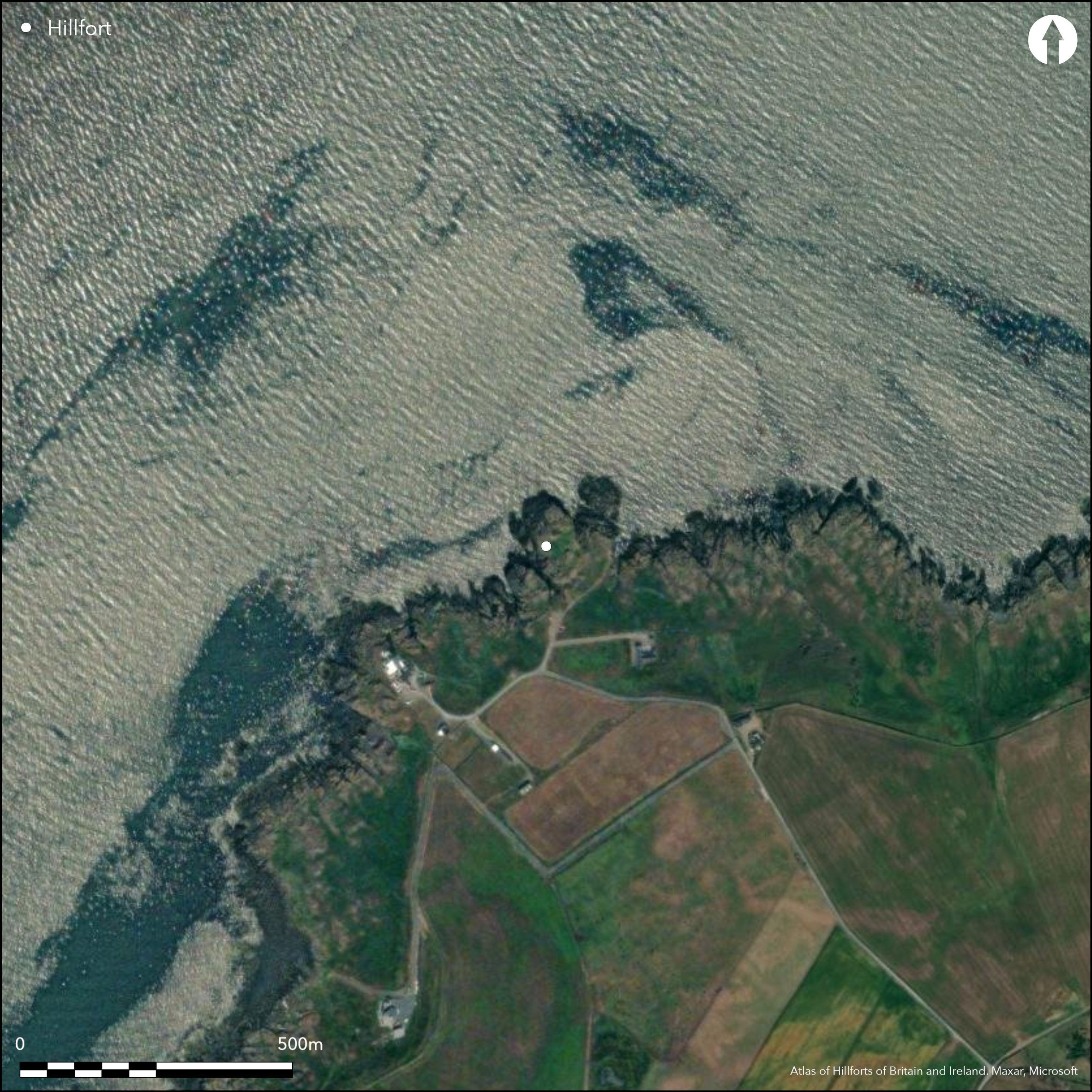
Satellite Imagery
LiDAR 1m DTM Hillshade
Satellite Imagery
Scroll left/right to view further images.
HER: Dumfries & Galloway MDG4588 (None)
NMR: NW 97 SE 1 (60406)
SM: 4884
NGR: NW 9823 7273
X: 198230 Y: 572730 (OSGB36)
The defences of this fort exploit a deep natural fissure that cuts off the landward approach to a precipitous promontory some 200m NE of Corsewall Lighthouse. The seaward side of the fissure rises into a rocky knoll forming the crest of the promontory, and this provides the foundation for a single wall that cuts across from SW to NE, before turning sharply northwards to link up with the unscalable cliffs on the E. On the crest of the knoll the wall has been reduced to little more than a spread of rubble up to 2.5m thick, but a few outer facing-stones are visible, including the basal course of the outer angle of its SW terminal, perched on an outcrop 1.9m below the crest of the knoll. To the NE the wall drops down off the knoll and its course is indicated by a line of large irregular boulders set along the lip of the fissure, though the latter here is only a shallow surface feature. The entrance probably lay towards the NE end of this sector of the wall where there is a gap some 3.4m wide in the rock outcrops; two large boulders visible here probably belong to the SW face of the entrance passage. Beyond the entrance little more than a scatter of debris remains to mark its line across the outcrops and back to the cliff edge. The only feature visible within the interior, which is largely outcrop and measures 71m from N to S by up to 41m transversely, is a roughly circular mound lying towards its E side; some 6.5m in diameter by 0.8m in height, it has a shallow depression in its top.
Citizen Science: ✗
Reliability of Data: Confirmed
Reliability of Interpretation: Confirmed
X: -574063 Y: 7363445 (EPSG: 3857)
Longitude: -5.156892654728956 Latitude: 55.00813350981273 (EPSG:4326)
Country: Scotland
Current County or Unitary Authority: Dumfries & Galloway
Historic County: Wigtownshire
Current Parish/Community/Council/Townland: Kirkcolm
Heavily robbed wall.
| Extant | ✓ |
| Cropmark | ✗ |
| Likely Destroyed | ✗ |
None
| Woodland | ✗ |
| Commercial Forestry Plantation | ✗ |
| Parkland | ✗ |
| Pasture (Grazing) | ✗ |
| Arable | ✗ |
| Scrub/Bracken | ✗ |
| Bare Outcrop | ✗ |
| Heather/Moorland | ✗ |
| Heath | ✗ |
| Built-up | ✗ |
| Coastal Grassland | ✓ |
| Other | ✗ |
None
| Contour Fort | ✗ |
| Partial Contour Fort | ✗ |
| Promontory Fort | ✓ |
| Hillslope Fort | ✗ |
| Level Terrain Fort | ✗ |
| Marsh Fort | ✗ |
| Multiple Enclosure Fort | ✗ |
| Hilltop | ✗ |
| Coastal Promontory | ✓ |
| Inland Promontory | ✗ |
| Valley Bottom | ✗ |
| Knoll/Hillock/Outcrop | ✗ |
| Ridge | ✗ |
| Cliff/Plateau-edge/Scarp | ✗ |
| Hillslope | ✗ |
| Lowland | ✗ |
| Spur | ✗ |
Dominant Topographic Feature: None
| North | ✗ |
| Northeast | ✗ |
| East | ✗ |
| Southeast | ✗ |
| South | ✗ |
| Southwest | ✗ |
| West | ✗ |
| Northwest | ✗ |
| Level | ✓ |
Altitude: 10.0m
N/A
In the absence of excavation, there are neither stratified artefacts nor radiocarbon dates to provide a chronology for the defences.
Reliability: D - None
| Pre 1200BC | ✗ |
| 1200BC - 800BC | ✗ |
| 800BC - 400BC | ✗ |
| 400BC - AD50 | ✗ |
| AD50 - AD400 | ✗ |
| AD400 - AD 800 | ✗ |
| Post AD800 | ✗ |
| Unknown | ✓ |
| Pre Hillfort: | None |
| Post Hillfort: | Circular mound noted in the interior may be of later date. |
Identified in the 1880s by George Wilson and planned with a professional surveyor in 1884 (1885, 67-8, pl xv), the fort subsequently appears on the OS 25-inch map of Wigtownshire surveyed in 1892, which also shows the circular mound within the interior. A written description was drawn up in 1911 (RCAHMS 1912, 32, no. 75). The fort was re-surveyed by the OS at 1:2500 in 1968, and a new plan at 1:500 was drawn up by RCAHMS in 1984. It was Scheduled in 1990
| Earthwork Survey (1884): | Plan and profiles RCAHMS DC 59002 & 59004 (SAS455) |
| 1st Identified Map Depiction (1892): | Annotated Fort on the OS 25-inch map (Wigtownshire 1894, sheet 4.4) |
| Other (1911): | Description (RCAHMS 1912, 32, no. 75) |
| Other (1968): | Resurveyed by the OS at 1:2500 |
| Earthwork Survey (1984): | Re-surveyed 1:500 by RCAHMS (DC 666) |
| Other (1990): | Scheduled |
Small circular mound
None
| None | ✓ |
| Spring | ✗ |
| Stream | ✗ |
| Pool | ✗ |
| Flush | ✗ |
| Well | ✗ |
| Other | ✗ |
Circular mound some 6.5m in diameter by 0.8m in height, with a shallow depression at its centre,
| No Known Features | ✗ |
| Round Stone Structures | ✗ |
| Rectangular Stone Structures | ✗ |
| Curvilinear Platforms | ✗ |
| Other Roundhouse Evidence | ✗ |
| Pits | ✗ |
| Quarry Hollows | ✗ |
| Other | ✓ |
None
| No Known Excavation | ✓ |
| Pits | ✗ |
| Postholes | ✗ |
| Roundhouses | ✗ |
| Rectangular Structures | ✗ |
| Roads/Tracks | ✗ |
| Quarry Hollows | ✗ |
| Other | ✗ |
| Nothing Found | ✗ |
None
| No Known Geophysics | ✓ |
| Pits | ✗ |
| Roundhouses | ✗ |
| Rectangular Structures | ✗ |
| Roads/Tracks | ✗ |
| Quarry Hollows | ✗ |
| Other | ✗ |
| Nothing Found | ✗ |
None
| No Known Finds | ✓ |
| Pottery | ✗ |
| Metal | ✗ |
| Metalworking | ✗ |
| Human Bones | ✗ |
| Animal Bones | ✗ |
| Lithics | ✗ |
| Environmental | ✗ |
| Other | ✗ |
None
| APs Not Checked | ✗ |
| None | ✓ |
| Roundhouses | ✗ |
| Rectangular Structures | ✗ |
| Pits | ✗ |
| Postholes | ✗ |
| Roads/Tracks | ✗ |
| Other | ✗ |
See main summary
| 1: | None |
| 2: | None |
Guard Chambers: ✗
Chevaux de Frise: ✗
| 1. Simple Gap (South east): | None |
Single wall
| Area 1: | 0.26ha. |
| Total: | 0.26ha. |
Total Footprint Area: 0.28ha.
None
| ✗ | None |
| ✗ | None |
| NE Quadrant: | 0 |
| SE Quadrant: | 1 |
| SW Quadrant: | 0 |
| NW Quadrant: | 0 |
| Total: | 1 |
| Partial Univallate | ✓ |
| Univallate | ✗ |
| Partial Bivallate | ✗ |
| Bivallate | ✗ |
| Partial Multivallate | ✗ |
| Multivallate | ✗ |
| Unknown | ✗ |
| Partial Univallate | ✗ |
| Univallate | ✗ |
| Partial Bivallate | ✗ |
| Bivallate | ✗ |
| Partial Multivallate | ✗ |
| Multivallate | ✗ |
None
| None | ✗ |
| Earthen Bank | ✗ |
| Stone Wall | ✓ |
| Rubble | ✗ |
| Wall-walk | ✗ |
| Evidence of Timber | ✗ |
| Vitrification | ✗ |
| Other Burning | ✗ |
| Palisade | ✗ |
| Counter Scarp Bank | ✗ |
| Berm | ✗ |
| Unfinished | ✗ |
| Other | ✗ |
None
| None | ✗ |
| Earthen Bank | ✗ |
| Stone Wall | ✗ |
| Murus Duplex | ✗ |
| Timber-framed | ✗ |
| Timber-laced | ✗ |
| Vitrification | ✗ |
| Other Burning | ✗ |
| Palisade | ✗ |
| Counter Scarp Bank | ✗ |
| Berm | ✗ |
| Unfinished | ✗ |
| No Known Excavation | ✓ |
| Other | ✗ |
| ✗ | None |
| ✗ | None |
Number of Ditches: None
| ✗ | None |
Wilson, G (1885) 'Description of ancient forts, etc., in Wigtownshire'. Archaeol Hist Collect Ayrshire Galloway 5(1885), 62-73.
RCAHMS (1912) The Royal Commission on the Ancient and Historical Monuments and Constructions of Scotland. Fourth report and inventory of monuments and constructions in Galloway, 1, county of Wigtown, Edinburgh.
Atlas of Hillforts:
Wikidata:
This work is licensed under CC BY-SA 4.0![]()
![]()
![]() and should be cited as:
and should be cited as:
Lock, Gary and Ralston, Ian. 2024. Atlas of Hillforts of Britain and Ireland. Available at: https://hillforts.arch.ox.ac.uk
Document Version 1.1