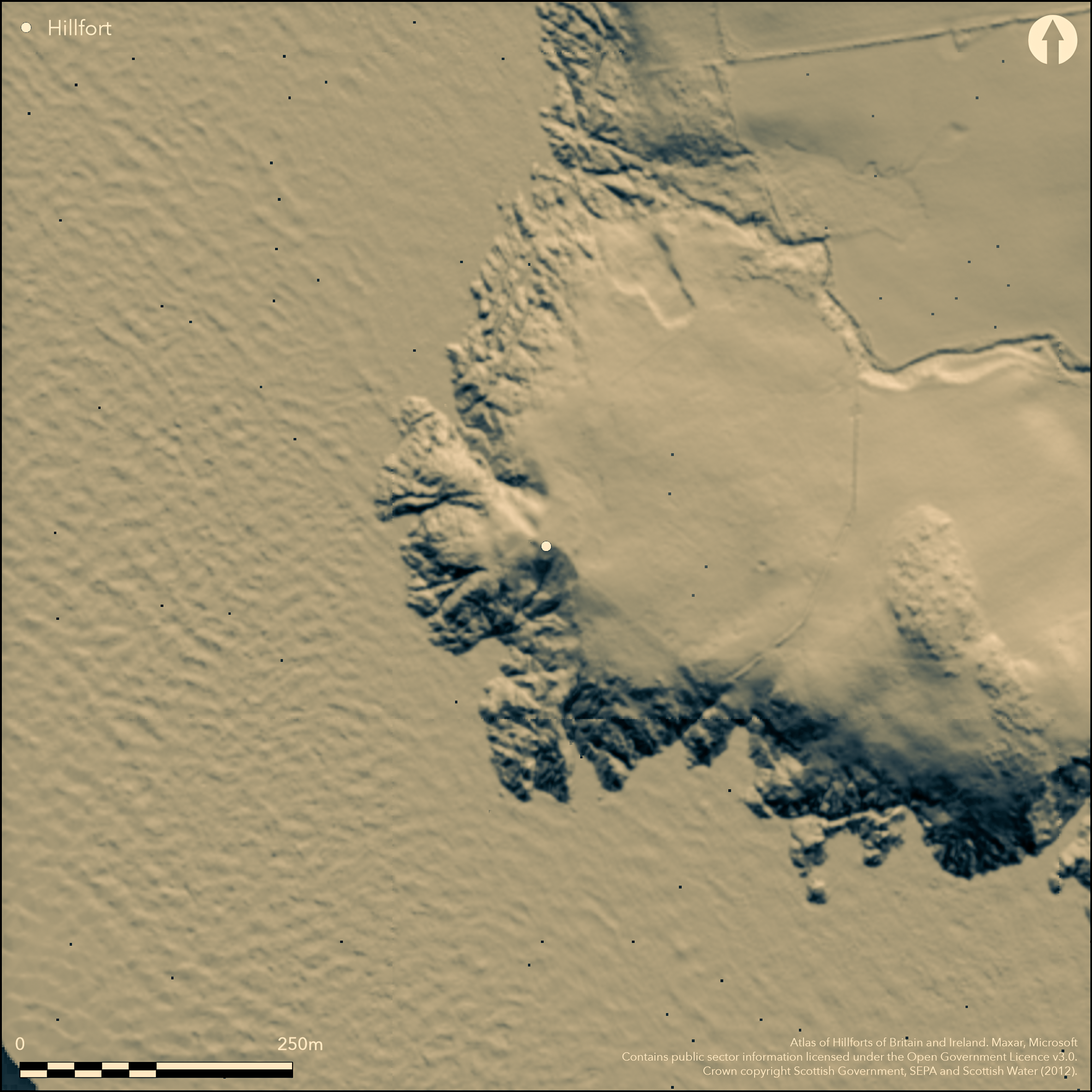
LiDAR 1m DTM Hillshade
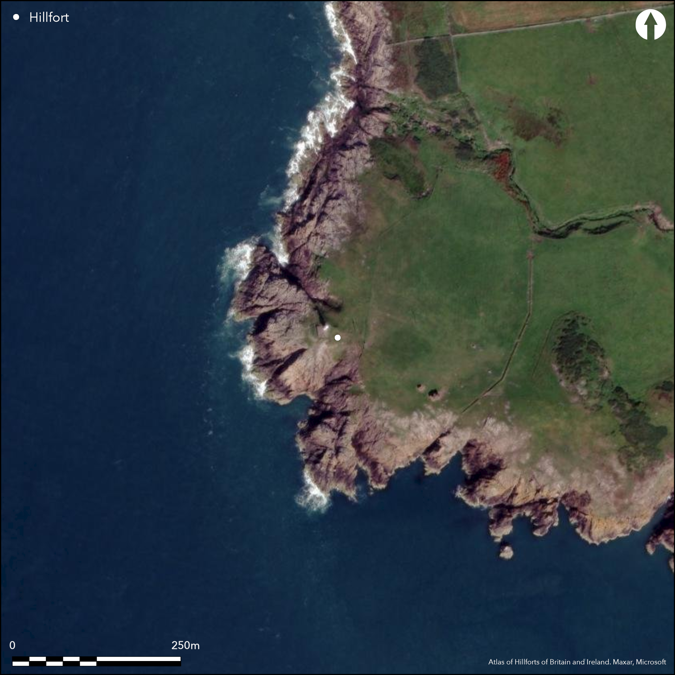
Satellite Imagery
LiDAR 1m DTM Hillshade
Satellite Imagery
Scroll left/right to view further images.
HER: Dumfries & Galloway MDG602 (None)
NMR: NX 03 SE 1 (60437)
SM: 1964
NGR: NX 0891 3404
X: 208910 Y: 534040 (OSGB36)
This promontory fort occupies Crammag Head, a bare rocky headland crowned by a small lighthouse on the W coast of the Rhinns of Galloway. Its defences comprise a single rampart with an external ditch, which cut off the landward approach from the E. The rampart has been heavily damaged and at its N end has been reduced to little more than a scatter of stones, but towards the S it increases to a maximum of 4.4m in thickness by 0.5m in height, and the accompanying ditch is 5.5m in breadth by 0.3m in depth; a gap between their southern terminals and the edge of the promontory probably marks the position of the entrance. The extent of the interior is difficult to determine, extending to a maximum of 0.6ha where the bare rock steps down to the sea on the W. The occupiable area, however, would have been considerably smaller and perhaps as little as 0.2ha, representing the current extent of continuous grass cover on the top of the promontory, which was formerly occupied by a broch or dun, though this was partly demolished about 1913 when the lighthouse was erected. The broch or dun measured about 19.5m in overall diameter, and while little more than a scatter of stones remains of its wall on the E, the basal course of the outer face, comprising massive granite blocks up to 1m in length, can be traced around the W, and up to three courses are visible on the NW. The broch or dun was positioned on the seaward side of a narrow neck formed by a precipitous crevice that runs into the headland from the NW some 20m behind the rampart of the fort. The crevice has been enhanced as a defensive outwork to the broch or dun, creating a broad ditch to either side of central causeway some 2.5m wide and faced on the S with granite boulders. On this side of the causeway the ditch is 6.5m in breadth by 1.1m in depth, but to the N its breadth increases to 9m and it is 1.3m in depth.
Citizen Science: ✗
Reliability of Data: Confirmed
Reliability of Interpretation: Confirmed
X: -552652 Y: 7297144 (EPSG: 3857)
Longitude: -4.964554330618584 Latitude: 54.665128139003755 (EPSG:4326)
Country: Scotland
Current County or Unitary Authority: Dumfries & Galloway
Historic County: Wigtownshire
Current Parish/Community/Council/Townland: Kirkmaiden
Parts of the rampart of the promontory fort are heavily damaged, and the broch or dun that occupied a large part of the interior was partly demolished for the construction of the lighthouse about 1913.
| Extant | ✓ |
| Cropmark | ✗ |
| Likely Destroyed | ✗ |
None
| Woodland | ✗ |
| Commercial Forestry Plantation | ✗ |
| Parkland | ✗ |
| Pasture (Grazing) | ✓ |
| Arable | ✗ |
| Scrub/Bracken | ✗ |
| Bare Outcrop | ✗ |
| Heather/Moorland | ✗ |
| Heath | ✗ |
| Built-up | ✗ |
| Coastal Grassland | ✓ |
| Other | ✗ |
None
| Contour Fort | ✗ |
| Partial Contour Fort | ✗ |
| Promontory Fort | ✓ |
| Hillslope Fort | ✗ |
| Level Terrain Fort | ✗ |
| Marsh Fort | ✗ |
| Multiple Enclosure Fort | ✗ |
None
| Hilltop | ✗ |
| Coastal Promontory | ✓ |
| Inland Promontory | ✗ |
| Valley Bottom | ✗ |
| Knoll/Hillock/Outcrop | ✗ |
| Ridge | ✗ |
| Cliff/Plateau-edge/Scarp | ✗ |
| Hillslope | ✗ |
| Lowland | ✗ |
| Spur | ✗ |
Dominant Topographic Feature: None
| North | ✗ |
| Northeast | ✗ |
| East | ✗ |
| Southeast | ✗ |
| South | ✗ |
| Southwest | ✗ |
| West | ✗ |
| Northwest | ✗ |
| Level | ✓ |
Altitude: 30.0m
N/A
The broch or dun and its outwork are likely to date from the 1st-2nd centuries AD
Reliability: D - None
| Pre 1200BC | ✗ |
| 1200BC - 800BC | ✗ |
| 800BC - 400BC | ✗ |
| 400BC - AD50 | ✗ |
| AD50 - AD400 | ✗ |
| AD400 - AD 800 | ✗ |
| Post AD800 | ✗ |
| Unknown | ✓ |
| Pre Hillfort: | None |
| Post Hillfort: | The broch or dun is likely to post-date the promontory fort |
| Morphology/Earthwork/Typology: | Relates to broch architecture |
Noted by the OS in 1848, the fort was later visited by William M'Ilwraith, who claimed to have found vitrified rock in the rampart of the fort (1877, 138-9), and George Wilson in the 1880s (1885, 62-73), who was probably responsible for the plan and sketches in the collection of RCAHMS; one of the latter is a stylised impression, but the other is a superb depiction of the broch, its outworks and all the rock, and is almost certainly by a professional surveyor's hand rather than Wilson himself. A measured plan was drawn up in 1911 for the Wigtownshire County Inventory (RCAHMS 1912 55, Fig. 40) shortly before the construction of the lighthouse, and it was subsequently Scheduled in 1938. It was re-surveyed by the OS at 1:2500 in 1972 and revisited by RCAHMS in 1984. A watching brief for the provision of services to a new lighthouse in 2009 did not observe any archaeological features (Hindmarch 2009, 60).
| 1st Identified Map Depiction (1848): | Annotated Crammag Fort on the 1st edition OS 6-inch map (Wigtownshire 1848, sheet 35) |
| Other (1877): | William M'Ilwraith, who claimed to have found vitrified rock (1877, 138-9) |
| Earthwork Survey (1911): | Plan and description )RCAHMS 1912, 54-5, No. 143, Fig. 40) |
| Other (1938): | Scheduled |
| Other (1972): | Resurveyed at 1:2500 by the OS |
| Other (1984): | Description by RCAHMS |
| Other (2009): | Watching brief for services to lighthouse (Hindmarch 2009) |
| Other (2009): | Watching brief (Hindmarch 2009, 60) |
| Earthwork Survey (None): | Probably by George Wilson (1885, 62-73; RCAHMS WGD 56/1-2, SAS 454) |
The now-diminished broch or dun may not be contemporary with the enclosure described here.
None
| None | ✓ |
| Spring | ✗ |
| Stream | ✗ |
| Pool | ✗ |
| Flush | ✗ |
| Well | ✗ |
| Other | ✗ |
broch
| No Known Features | ✗ |
| Round Stone Structures | ✗ |
| Rectangular Stone Structures | ✗ |
| Curvilinear Platforms | ✗ |
| Other Roundhouse Evidence | ✗ |
| Pits | ✗ |
| Quarry Hollows | ✗ |
| Other | ✓ |
Watching brief in 2009 observed no archaeological features.
| No Known Excavation | ✗ |
| Pits | ✗ |
| Postholes | ✗ |
| Roundhouses | ✗ |
| Rectangular Structures | ✗ |
| Roads/Tracks | ✗ |
| Quarry Hollows | ✗ |
| Other | ✗ |
| Nothing Found | ✓ |
None
| No Known Geophysics | ✓ |
| Pits | ✗ |
| Roundhouses | ✗ |
| Rectangular Structures | ✗ |
| Roads/Tracks | ✗ |
| Quarry Hollows | ✗ |
| Other | ✗ |
| Nothing Found | ✗ |
None
| No Known Finds | ✓ |
| Pottery | ✗ |
| Metal | ✗ |
| Metalworking | ✗ |
| Human Bones | ✗ |
| Animal Bones | ✗ |
| Lithics | ✗ |
| Environmental | ✗ |
| Other | ✗ |
None
| APs Not Checked | ✗ |
| None | ✓ |
| Roundhouses | ✗ |
| Rectangular Structures | ✗ |
| Pits | ✗ |
| Postholes | ✗ |
| Roads/Tracks | ✗ |
| Other | ✗ |
See main summary
| 2: | Only one in the defences of the promontory fort, the second being through the outwork of the broch dun. |
| 2: | Single entrance in each phase enumerated separately below |
Guard Chambers: ✗
Chevaux de Frise: ✗
| 1. Simple Gap (East): | Between the fort defences and the edge of the promontory. |
| 2. Simple Gap (East): | Central causeway across the ditch of the outwork to the broch. |
Single rampart, from which a piece of vitrified stone is said to have been recovered in the 19th century.
| Area 1: | 0.6ha. |
| Total: | 0.6ha. |
Total Footprint Area: 0.7ha.
The outwork of the dun or broch is not counted here as part of the fort defences.
| ✗ | None |
| ✗ | Cut across the neck of a promontory |
| NE Quadrant: | 1 |
| SE Quadrant: | 0 |
| SW Quadrant: | 0 |
| NW Quadrant: | 0 |
| Total: | 1 |
| Partial Univallate | ✓ |
| Univallate | ✗ |
| Partial Bivallate | ✗ |
| Bivallate | ✗ |
| Partial Multivallate | ✗ |
| Multivallate | ✗ |
| Unknown | ✗ |
| Partial Univallate | ✗ |
| Univallate | ✗ |
| Partial Bivallate | ✗ |
| Bivallate | ✗ |
| Partial Multivallate | ✗ |
| Multivallate | ✗ |
Piece of vitirified stone claimed in the 19th century.
| None | ✗ |
| Earthen Bank | ✓ |
| Stone Wall | ✗ |
| Rubble | ✗ |
| Wall-walk | ✗ |
| Evidence of Timber | ✗ |
| Vitrification | ✓ |
| Other Burning | ✗ |
| Palisade | ✗ |
| Counter Scarp Bank | ✗ |
| Berm | ✗ |
| Unfinished | ✗ |
| Other | ✗ |
None
| None | ✗ |
| Earthen Bank | ✗ |
| Stone Wall | ✗ |
| Murus Duplex | ✗ |
| Timber-framed | ✗ |
| Timber-laced | ✗ |
| Vitrification | ✗ |
| Other Burning | ✗ |
| Palisade | ✗ |
| Counter Scarp Bank | ✗ |
| Berm | ✗ |
| Unfinished | ✗ |
| No Known Excavation | ✓ |
| Other | ✗ |
| ✗ | None |
| ✓ | None |
Number of Ditches: 1
| ✗ | None |
Feachem, R (1963) A guide to prehistoric Scotland, London (p 174)
Hindmarch, E (2009a) 'Crammag Head, Dumfries and Galloway (Kirkmaiden parish), watching brief', Discovery Excav Scot, New Series, vol.10, (Cathedral Communications Limited, Wiltshire, England).
M'Ilwraith, W (1877) The visitors' guide to Wigtownshire: with notes, historical antiquarian and descriptive, upon the burghs, towns, villages, gentlemen's seats, ruins and other places of interest in the county, Dumfries
MacKie, E W (2007) The Roundhouses, Brochs and Wheelhouses of Atlantic Scotland c.700 BC-AD 500: architecture and material culture, the Northern and Southern Mainland and the Western Islands, BAR British series 444(II), 444(1), 2 V Oxford
Name Book, Ordnance Survey Object Name Books (6 inch and 1/2500 scale), (Wigtownshire), No.86, p 35; available https://www.scotlandsplaces.gov.uk/
RCAHMS (1912) The Royal Commission on the Ancient and Historical Monuments and Constructions of Scotland. Fourth report and inventory of monuments and constructions in Galloway, 1, county of Wigtown, Edinburgh (54-5, No.143, fig.40)
RCAHMS (1950-9) Marginal Land Survey (unpublished typescript held at RCAHMS)
Todd, W (1854) 'Statistical, historical and miscellaneous memoranda connected with the parish of Kirkmaiden', copy of unpublished manuscript in Stranraer public library (p 13, 44-5)
Wilson, G (1885) 'Description of ancient forts, etc., in Wigtownshire'. Archaeol Hist Collect Ayrshire Galloway 5 (1885), 62-73
Atlas of Hillforts:
Wikidata:
This work is licensed under CC BY-SA 4.0![]()
![]()
![]() and should be cited as:
and should be cited as:
Lock, Gary and Ralston, Ian. 2024. Atlas of Hillforts of Britain and Ireland. Available at: https://hillforts.arch.ox.ac.uk
Document Version 1.1