Satellite Imagery
Satellite Imagery
HER: Dumfries & Galloway MDG603 (None)
NMR: NX 03 SE 2 (60438)
SM: 1975
NGR: NX 0978 3350
X: 209780 Y: 533500 (OSGB36)
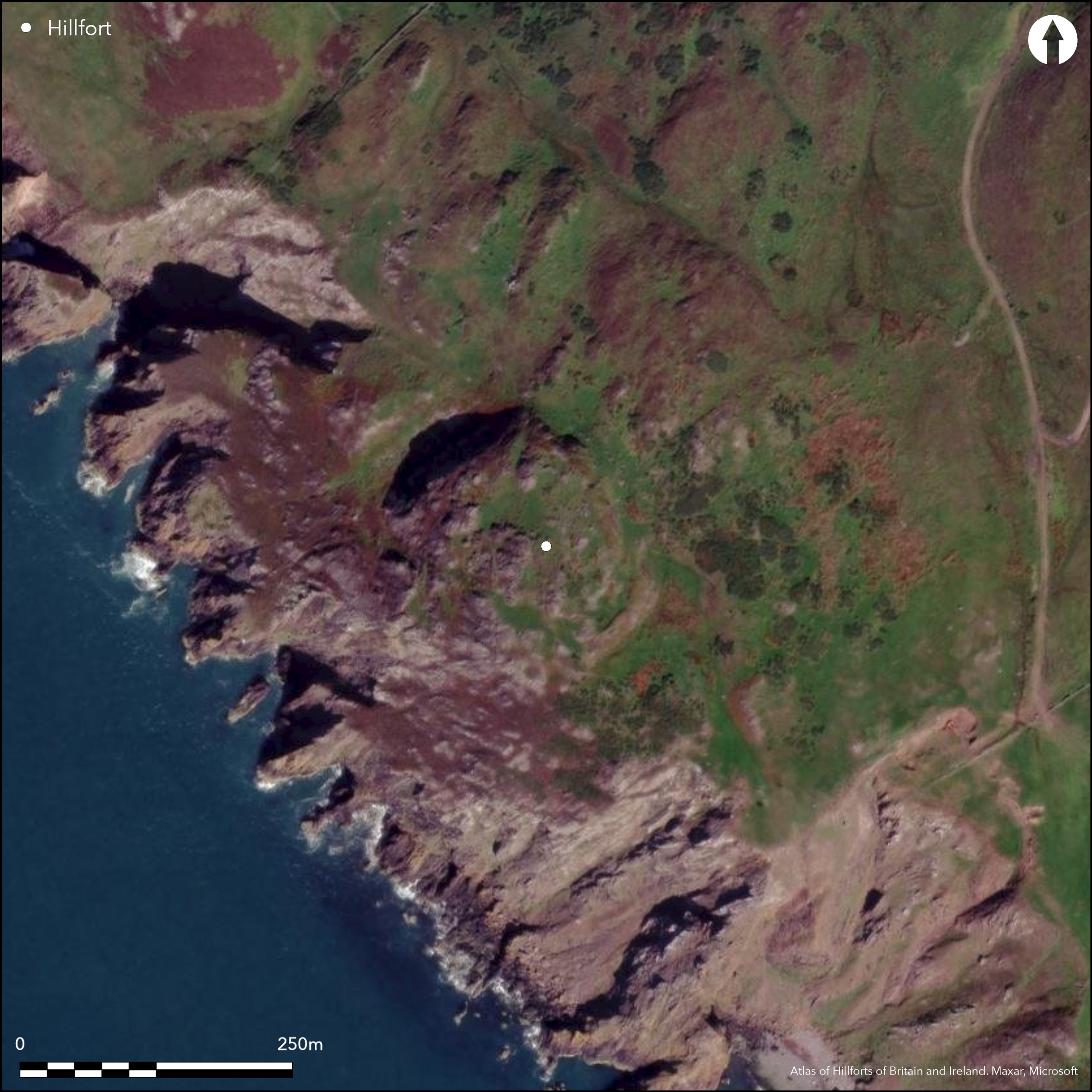
This fort occupies the summit of Dunman, a flat rocky summit on the precipitous western coast of the Rhinns of Galloway. Its defences comprise a single wall, which follows the crest of a natural escarpment some 7m high around the eastern half of the summit from the N round to the SSW. Elsewhere the topography appear to have provided sufficient protection, on the SW falling away into the sea. The wall itself has been reduced to little more than a band of rubble spread 3.5m in maximum thickness and 1m in height, and in addition to a natural terrace that provides access to the interior on the N, there are original entrances on the NNE and S, while a gap on the ESE was probably made when large quantities of stone were removed in 1848 to build a march dyke. The rocky interior, which measures 100m from N to S by a maximum of 78m transversely, is featureless.
Citizen Science: ✗
Reliability of Data: Confirmed
Reliability of Interpretation: Confirmed
X: -551113 Y: 7296274 (EPSG: 3857)
Longitude: -4.950732477059617 Latitude: 54.66061080780802 (EPSG:4326)
Country: Scotland
Current County or Unitary Authority: Dumfries & Galloway
Historic County: Wigtownshire
Current Parish/Community/Council/Townland: Kirkmaiden
None
| Extant | ✓ |
| Cropmark | ✗ |
| Likely Destroyed | ✗ |
None
| Woodland | ✗ |
| Commercial Forestry Plantation | ✗ |
| Parkland | ✗ |
| Pasture (Grazing) | ✓ |
| Arable | ✗ |
| Scrub/Bracken | ✓ |
| Bare Outcrop | ✗ |
| Heather/Moorland | ✗ |
| Heath | ✗ |
| Built-up | ✗ |
| Coastal Grassland | ✓ |
| Other | ✗ |
This feature is a summit along a precipitous coastal escarpment.
| Contour Fort | ✓ |
| Partial Contour Fort | ✗ |
| Promontory Fort | ✗ |
| Hillslope Fort | ✗ |
| Level Terrain Fort | ✗ |
| Marsh Fort | ✗ |
| Multiple Enclosure Fort | ✗ |
| Hilltop | ✗ |
| Coastal Promontory | ✗ |
| Inland Promontory | ✗ |
| Valley Bottom | ✗ |
| Knoll/Hillock/Outcrop | ✗ |
| Ridge | ✗ |
| Cliff/Plateau-edge/Scarp | ✓ |
| Hillslope | ✗ |
| Lowland | ✗ |
| Spur | ✗ |
Dominant Topographic Feature: None
| North | ✗ |
| Northeast | ✗ |
| East | ✗ |
| Southeast | ✗ |
| South | ✗ |
| Southwest | ✗ |
| West | ✗ |
| Northwest | ✗ |
| Level | ✓ |
Altitude: 150.0m
N/A
In the absence of excavation, there are neither stratified artefacts nor radiocarbon dates to provide a chronology for the defences.
Reliability: D - None
| Pre 1200BC | ✗ |
| 1200BC - 800BC | ✗ |
| 800BC - 400BC | ✗ |
| 400BC - AD50 | ✗ |
| AD50 - AD400 | ✗ |
| AD400 - AD 800 | ✗ |
| Post AD800 | ✗ |
| Unknown | ✓ |
| Pre Hillfort: | None |
| Post Hillfort: | None |
Apparently depicted but not annotated on Roy's Map (1847-55), the fort appears on the 1st edition of the OS 6-inch map (Wigtownshire 1850, sheet 35) and was noted by George Wilson, who also drew up a rough plan (1885, 62) and RCAHMS (1912, 55-6, No. 144). The fort was Scheduled in 1938,and re-surveyed at 1:2500 by the OS in 1972, and revisited by RCAHMS in 1984.
| 1st Identified Map Depiction (1755): | Apparently depicted but not annotated |
| Other (1848): | Annotated Fort on the 1st edition OS 6-inch map (Wigtownshire 1850, sheet 35) |
| Other (1911): | Description by RCAHMS (1912, 55-6, No. 144) |
| Other (1938): | Scheduled |
| Other (1972): | Resurveyed at 1:2500 by the OS |
| Other (1984): | Description by RCAHMS |
| 1st Identified Written Reference (None): | Wilson (1885, 62) |
| Earthwork Survey (None): | Sketch-plan by George Wilson (RCAHMS SAS454) |
Featureless
Shown below the summit on the seaward side on OS maps.
| None | ✗ |
| Spring | ✓ |
| Stream | ✗ |
| Pool | ✗ |
| Flush | ✗ |
| Well | ✗ |
| Other | ✗ |
None
| No Known Features | ✓ |
| Round Stone Structures | ✗ |
| Rectangular Stone Structures | ✗ |
| Curvilinear Platforms | ✗ |
| Other Roundhouse Evidence | ✗ |
| Pits | ✗ |
| Quarry Hollows | ✗ |
| Other | ✗ |
None
| No Known Excavation | ✓ |
| Pits | ✗ |
| Postholes | ✗ |
| Roundhouses | ✗ |
| Rectangular Structures | ✗ |
| Roads/Tracks | ✗ |
| Quarry Hollows | ✗ |
| Other | ✗ |
| Nothing Found | ✗ |
None
| No Known Geophysics | ✓ |
| Pits | ✗ |
| Roundhouses | ✗ |
| Rectangular Structures | ✗ |
| Roads/Tracks | ✗ |
| Quarry Hollows | ✗ |
| Other | ✗ |
| Nothing Found | ✗ |
None
| No Known Finds | ✓ |
| Pottery | ✗ |
| Metal | ✗ |
| Metalworking | ✗ |
| Human Bones | ✗ |
| Animal Bones | ✗ |
| Lithics | ✗ |
| Environmental | ✗ |
| Other | ✗ |
None
| APs Not Checked | ✗ |
| None | ✓ |
| Roundhouses | ✗ |
| Rectangular Structures | ✗ |
| Pits | ✗ |
| Postholes | ✗ |
| Roads/Tracks | ✗ |
| Other | ✗ |
See main summary
| 4: | Gap on ESE probably formed by stone robbers in 1848. |
| 2: | None |
Guard Chambers: ✗
Chevaux de Frise: ✗
| 1. Simple Gap (North): | Natural terrace at end of the wall |
| 2. Simple Gap (North east): | Shallow hollow descends from the gap |
| 3. Simple Gap (South): | Natural terrace descends slope |
Single wall. Although there have been claims of an outer wall at the foot of the escarpment, it is more likely that this relates to rubble that had tumbled down the steep slope.
| Area 1: | 0.8ha. |
| Total: | 0.8ha. |
Total Footprint Area: 0.8ha.
None
| ✗ | None |
| ✗ | None |
| NE Quadrant: | 1 |
| SE Quadrant: | 1 |
| SW Quadrant: | 0 |
| NW Quadrant: | 0 |
| Total: | 1 |
| Partial Univallate | ✓ |
| Univallate | ✗ |
| Partial Bivallate | ✗ |
| Bivallate | ✗ |
| Partial Multivallate | ✗ |
| Multivallate | ✗ |
| Unknown | ✗ |
| Partial Univallate | ✗ |
| Univallate | ✗ |
| Partial Bivallate | ✗ |
| Bivallate | ✗ |
| Partial Multivallate | ✗ |
| Multivallate | ✗ |
None
| None | ✗ |
| Earthen Bank | ✗ |
| Stone Wall | ✗ |
| Rubble | ✓ |
| Wall-walk | ✗ |
| Evidence of Timber | ✗ |
| Vitrification | ✗ |
| Other Burning | ✗ |
| Palisade | ✗ |
| Counter Scarp Bank | ✗ |
| Berm | ✗ |
| Unfinished | ✗ |
| Other | ✗ |
None
| None | ✗ |
| Earthen Bank | ✗ |
| Stone Wall | ✗ |
| Murus Duplex | ✗ |
| Timber-framed | ✗ |
| Timber-laced | ✗ |
| Vitrification | ✗ |
| Other Burning | ✗ |
| Palisade | ✗ |
| Counter Scarp Bank | ✗ |
| Berm | ✗ |
| Unfinished | ✗ |
| No Known Excavation | ✓ |
| Other | ✗ |
| ✗ | None |
| ✗ | None |
Number of Ditches: None
| ✗ | None |
Feachem, R (1963b) A guide to prehistoric Scotland, London Page(s): 161 Held at RCAHMS E.2.FEA
RCAHMS (1912) The Royal Commission on the Ancient and Historical Monuments and Constructions of Scotland. Fourth report and inventory of monuments and constructions in Galloway, 1, county of Wigtown, Edinburgh. (p 55-6, No.144)
RCAHMS (1950-9) Marginal Land Survey (unpublished typescripts).
Wilson, G (1885) 'Description of ancient forts, etc., in Wigtownshire'. Archaeol Hist Collect Ayrshire Galloway 5 (1885), 62-73
Atlas of Hillforts:
Wikidata:
This work is licensed under CC BY-SA 4.0![]()
![]()
![]() and should be cited as:
and should be cited as:
Lock, Gary and Ralston, Ian. 2024. Atlas of Hillforts of Britain and Ireland. Available at: https://hillforts.arch.ox.ac.uk
Document Version 1.1