LiDAR 1m DTM Hillshade
Satellite Imagery
LiDAR 1m DTM Hillshade
Satellite Imagery
Scroll left/right to view further images.
HER: Dumfries & Galloway MDG13140 (None)
NMR: NX 05 NW 1 (60559)
SM: 1958
NGR: NX 0442 5632
X: 204420 Y: 556320 (OSGB36)
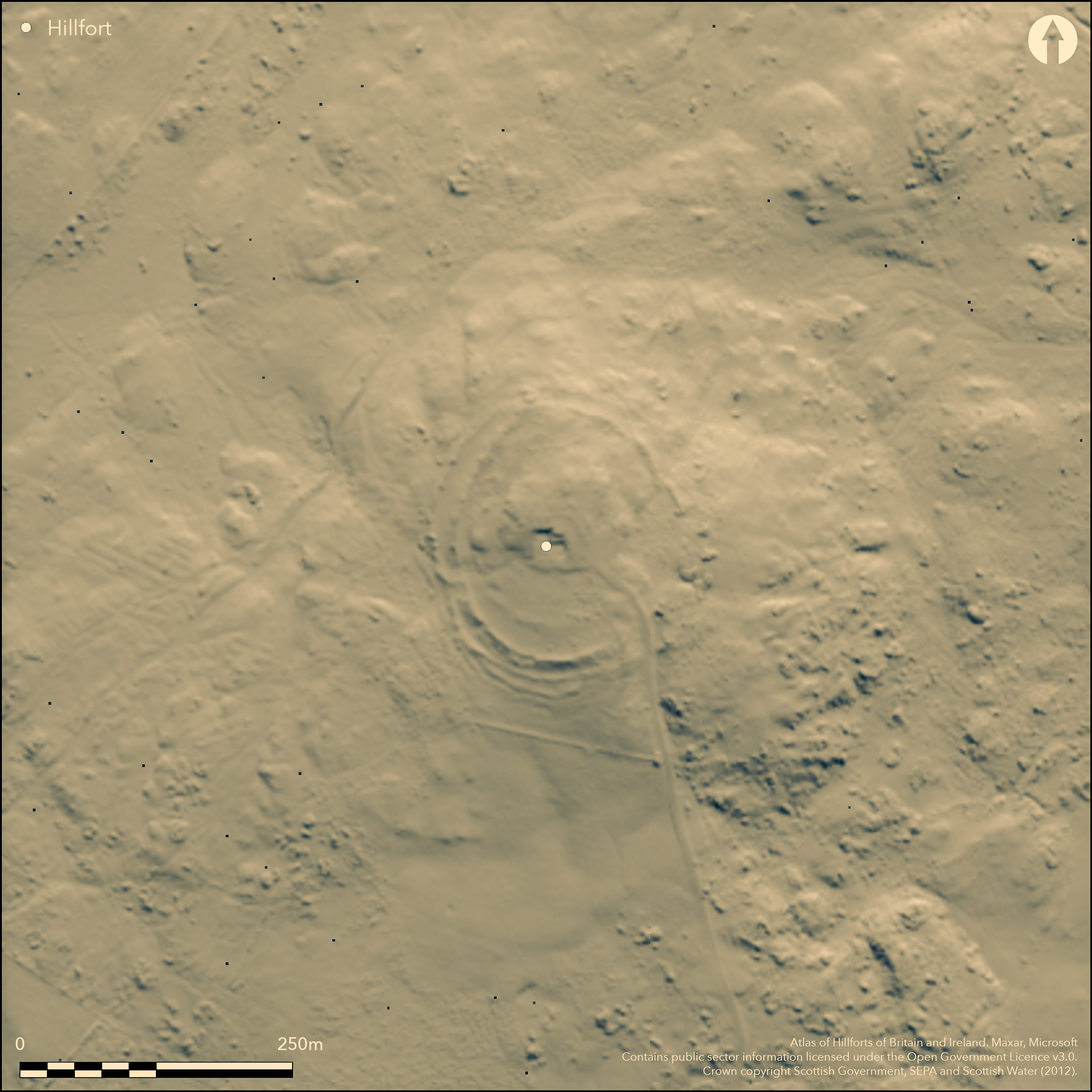
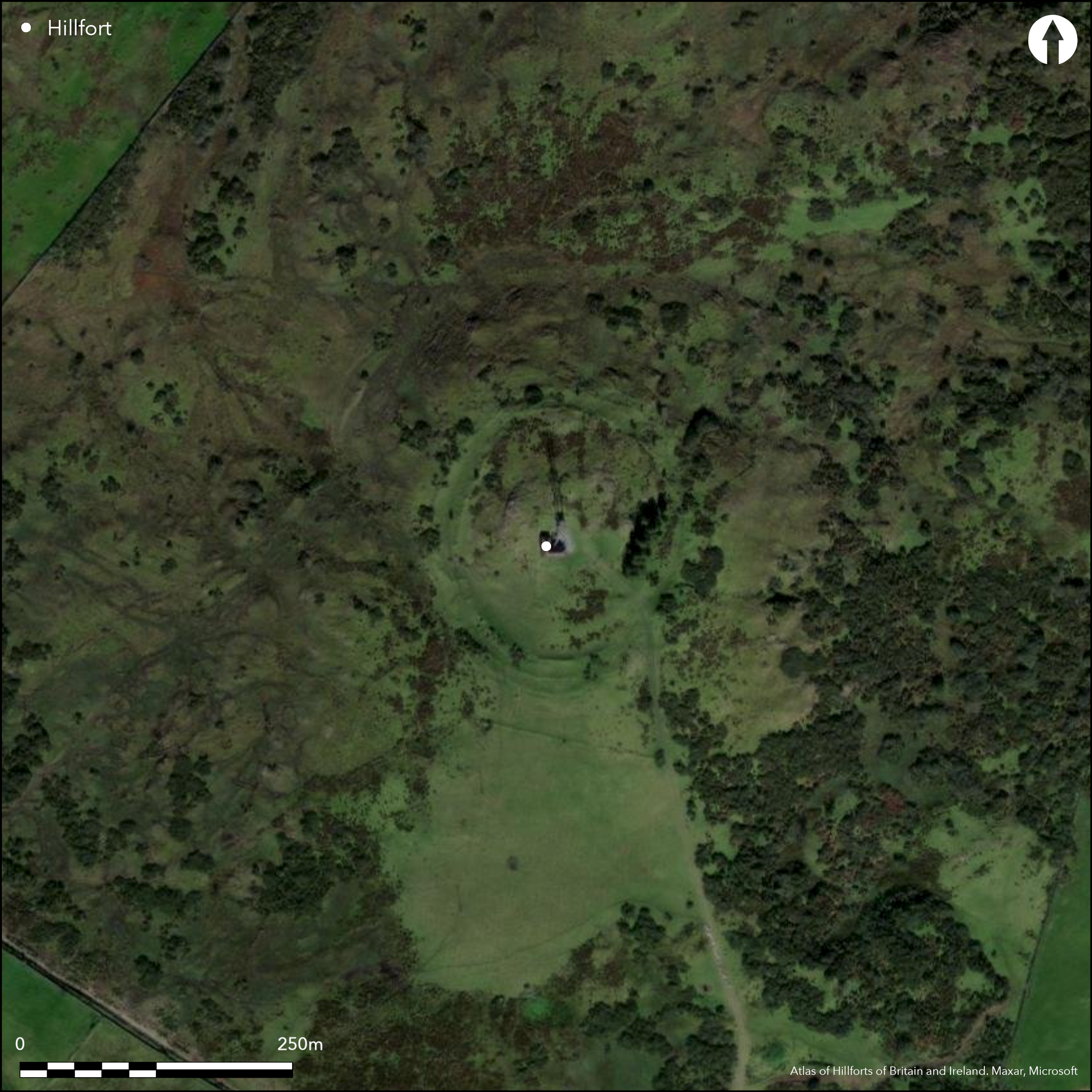
This fort, which with the exception of the promontory enclosure on the Mull of Galloway is the largest of those on the Rhinns of Galloway, is situated on the summit of Cairn Pat, a hill with commanding views in every direction. Slightly oval on plan, it measures 132m from N to S by 118m transversely (1.15ha) within a pair of ramparts set between 5.5m and 9.5m apart. A third rampart springs from the outer on the SW and swings round the S flank of the fort to probably return on the SSE, but this junction has been destroyed; another low bank with an external ditch lies outside the third rampart on the SW and can be traced in intermittent scatters of stones around the W side, finally petering out on the N. All the ramparts have been extensively robbed and in places are difficult to follow on the ground, but the innermost seems to have been the thickest, ranging from a bank of rubble up to 4.8m thick by 0.8m high on the S to a stony scarp some 1.5m high on the N, whereas the outer of this pair is spread up to 3.1m thick by a maximum of 0.6m high externally; around the S quarter, however, it appears to be flanked internally by a shallow quarry ditch. The third rampart forms a bank only 2m thick by 0.3m high. As a result of the robbing it is also difficult to be certain of the position of any entrances, though there are traces of returns linking the concentric inner pair of ramparts on the WSW. Other gaps on the NE appear modern, while on the SSE a plan drawn up in 1955 shows the ramparts crossing the line of the access road up to the telecommunication masts on the summit; this follows a natural hollow that extends up into the interior between a high rock outcrop on the W and a lower natural scarp on the E, but there is no evidence to show that this was originally exploited as an entrance. The interior is featureless and much of the summit area is made up of exposed bedrock.
Citizen Science: ✗
Reliability of Data: Confirmed
Reliability of Interpretation: Confirmed
X: -562060 Y: 7335390 (EPSG: 3857)
Longitude: -5.049075365820507 Latitude: 54.86334702917723 (EPSG:4326)
Country: Scotland
Current County or Unitary Authority: Dumfries & Galloway
Historic County: Wigtownshire
Current Parish/Community/Council/Townland: Portpatrick
None
| Extant | ✓ |
| Cropmark | ✗ |
| Likely Destroyed | ✗ |
Mainly rough pasture, but with scattered gorse bushes. Outcrop is generally close beneath the turf and is visible over much of the summit area.
| Woodland | ✗ |
| Commercial Forestry Plantation | ✗ |
| Parkland | ✗ |
| Pasture (Grazing) | ✓ |
| Arable | ✗ |
| Scrub/Bracken | ✓ |
| Bare Outcrop | ✗ |
| Heather/Moorland | ✗ |
| Heath | ✗ |
| Built-up | ✗ |
| Coastal Grassland | ✗ |
| Other | ✗ |
None
| Contour Fort | ✓ |
| Partial Contour Fort | ✗ |
| Promontory Fort | ✗ |
| Hillslope Fort | ✗ |
| Level Terrain Fort | ✗ |
| Marsh Fort | ✗ |
| Multiple Enclosure Fort | ✗ |
| Hilltop | ✓ |
| Coastal Promontory | ✗ |
| Inland Promontory | ✗ |
| Valley Bottom | ✗ |
| Knoll/Hillock/Outcrop | ✗ |
| Ridge | ✗ |
| Cliff/Plateau-edge/Scarp | ✗ |
| Hillslope | ✗ |
| Lowland | ✗ |
| Spur | ✗ |
Dominant Topographic Feature: A commanding and prominent hilltop with views dominating the whole of the Rhinns.
| North | ✗ |
| Northeast | ✗ |
| East | ✗ |
| Southeast | ✗ |
| South | ✗ |
| Southwest | ✗ |
| West | ✗ |
| Northwest | ✗ |
| Level | ✓ |
Altitude: 175.0m
N/A
There are neither stratified artefacts nor radiocarbon dates to provide a chronology for the defences.
Reliability: D - None
| Pre 1200BC | ✗ |
| 1200BC - 800BC | ✗ |
| 800BC - 400BC | ✗ |
| 400BC - AD50 | ✗ |
| AD50 - AD400 | ✗ |
| AD400 - AD 800 | ✗ |
| Post AD800 | ✗ |
| Unknown | ✓ |
| Pre Hillfort: | None |
| Post Hillfort: | None |
First noted by the OS surveyors in 1847, it was not surveyed at 1:2500 until 1893. Subsequently described in the County Inventory for Wigtownshire (RCAHMS 1912, 141, No. 413), in 1955 it was planned in more detail by RCAHMS. Subsequent visits have been carried out in 1968 by the OS and in 1984 by RCAHMS again. A watching brief was maintained for the digging of foundations within the telecommunications compound; no archaeological features were observed and the whole of the fenced area has been extensively disturbed (Fulford 2001, 28).
| 1st Identified Map Depiction (1847): | Annotated Fort on the 1st edition OS 6-inch map (Wigtownshire 1849, sheet 16) |
| Earthwork Survey (1893): | OS 1:2500 map (Wigtownshire 1894, sheet 17.11) |
| Other (1911): | Description (RCAHMS 1912, 141, No. 413) |
| Earthwork Survey (1955): | 1:400 (RCAHMS WGD 6/1-3) |
| Other (1968): | Resurveyed at 1:2500 by the OS |
| Other (1984): | Description by RCAHMS |
| Other (1995): | Scheduled; probably a rescheduling from c.1938/9 |
| Excavation (2001): | Watching brief (Fulford 2001, 28) |
| Other (2014): | Visit by the Hillfort Study Group |
Featureless
None
| None | ✓ |
| Spring | ✗ |
| Stream | ✗ |
| Pool | ✗ |
| Flush | ✗ |
| Well | ✗ |
| Other | ✗ |
None
| No Known Features | ✓ |
| Round Stone Structures | ✗ |
| Rectangular Stone Structures | ✗ |
| Curvilinear Platforms | ✗ |
| Other Roundhouse Evidence | ✗ |
| Pits | ✗ |
| Quarry Hollows | ✗ |
| Other | ✗ |
Nothing found
| No Known Excavation | ✗ |
| Pits | ✗ |
| Postholes | ✗ |
| Roundhouses | ✗ |
| Rectangular Structures | ✗ |
| Roads/Tracks | ✗ |
| Quarry Hollows | ✗ |
| Other | ✗ |
| Nothing Found | ✓ |
None
| No Known Geophysics | ✓ |
| Pits | ✗ |
| Roundhouses | ✗ |
| Rectangular Structures | ✗ |
| Roads/Tracks | ✗ |
| Quarry Hollows | ✗ |
| Other | ✗ |
| Nothing Found | ✗ |
Stone lamp was discovered during drainage operations NE of the fort (See Canmore NX05NW 7).
| No Known Finds | ✗ |
| Pottery | ✗ |
| Metal | ✗ |
| Metalworking | ✗ |
| Human Bones | ✗ |
| Animal Bones | ✗ |
| Lithics | ✗ |
| Environmental | ✗ |
| Other | ✓ |
None
| APs Not Checked | ✗ |
| None | ✓ |
| Roundhouses | ✗ |
| Rectangular Structures | ✗ |
| Pits | ✗ |
| Postholes | ✗ |
| Roads/Tracks | ✗ |
| Other | ✗ |
See main summary
| 4: | at least three gaps are related to stone-robbing or the creation of modern access to the summit. |
| 2: | None |
Guard Chambers: ✗
Chevaux de Frise: ✗
| 1. Passage-way/Corridor (West): | Traces of returns linking the two ramparts to either side of the gap. |
A concentric pair of ramparts, with at least one outer rampart on the southern quarter, and traces of another low bank around the W, though the relationship of this to the defences is unknown.
| Area 1: | 1.15ha. |
| Total: | 1.15ha. |
Total Footprint Area: 2.06ha.
None
| ✗ | None |
| ✓ | None |
| NE Quadrant: | 2 |
| SE Quadrant: | 2 |
| SW Quadrant: | 3 |
| NW Quadrant: | 2 |
| Total: | 3 |
| Partial Univallate | ✗ |
| Univallate | ✗ |
| Partial Bivallate | ✓ |
| Bivallate | ✗ |
| Partial Multivallate | ✓ |
| Multivallate | ✗ |
| Unknown | ✗ |
| Partial Univallate | ✗ |
| Univallate | ✗ |
| Partial Bivallate | ✗ |
| Bivallate | ✗ |
| Partial Multivallate | ✗ |
| Multivallate | ✗ |
None
| None | ✗ |
| Earthen Bank | ✗ |
| Stone Wall | ✗ |
| Rubble | ✓ |
| Wall-walk | ✗ |
| Evidence of Timber | ✗ |
| Vitrification | ✗ |
| Other Burning | ✗ |
| Palisade | ✗ |
| Counter Scarp Bank | ✗ |
| Berm | ✗ |
| Unfinished | ✗ |
| Other | ✗ |
Of the defences; limited evaluation within interior
| None | ✗ |
| Earthen Bank | ✗ |
| Stone Wall | ✗ |
| Murus Duplex | ✗ |
| Timber-framed | ✗ |
| Timber-laced | ✗ |
| Vitrification | ✗ |
| Other Burning | ✗ |
| Palisade | ✗ |
| Counter Scarp Bank | ✗ |
| Berm | ✗ |
| Unfinished | ✗ |
| No Known Excavation | ✓ |
| Other | ✗ |
| ✗ | None |
| ✓ | On the SW there are traces of an internal quarry to the rear of the outer of the pair of ramparts. |
Number of Ditches: 1
| ✗ | None |
Feachem, R (1963) A guide to prehistoric Scotland, London (p 160)
Fulford, H (2001) 'Cairnpat, Stranraer, Dumfries and Galloway (Portpatrick parish), watching brief', Discovery Excav Scot 2 (2001), 28.
RCAHMS (1912) The Royal Commission on the Ancient and Historical Monuments and Constructions of Scotland. Fourth report and inventory of monuments and constructions in Galloway, 1, county of Wigtown, Edinburgh.
Atlas of Hillforts:
Wikidata:
This work is licensed under CC BY-SA 4.0![]()
![]()
![]() and should be cited as:
and should be cited as:
Lock, Gary and Ralston, Ian. 2024. Atlas of Hillforts of Britain and Ireland. Available at: https://hillforts.arch.ox.ac.uk
Document Version 1.1