LiDAR 1m DTM Hillshade
Satellite Imagery
LiDAR 1m DTM Hillshade
Satellite Imagery
Scroll left/right to view further images.
HER: Dumfries & Galloway MDG989 (None)
NMR: NX 06 SW 1 (60830)
SM: 2001
NGR: NX 0085 6464
X: 200850 Y: 564640 (OSGB36)
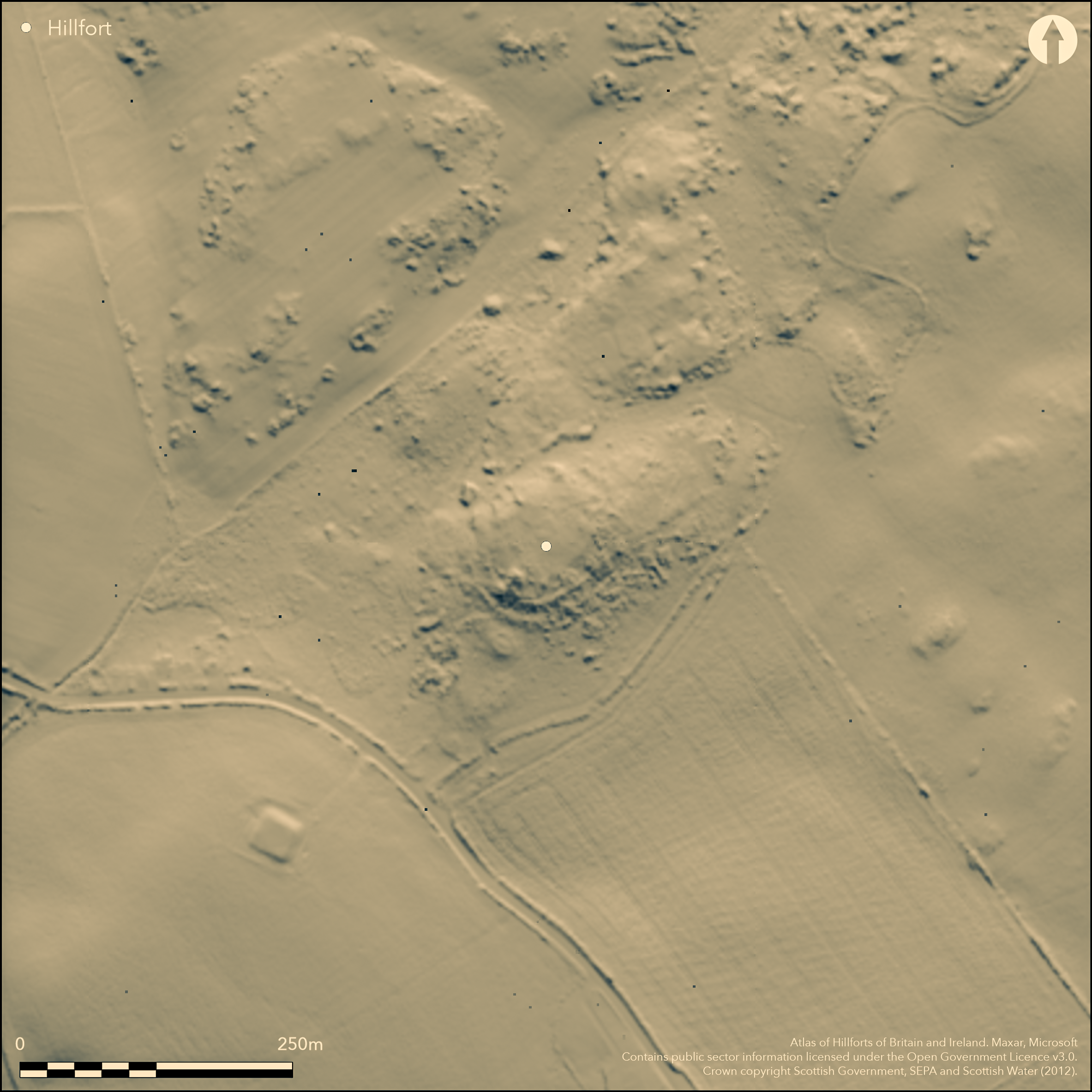
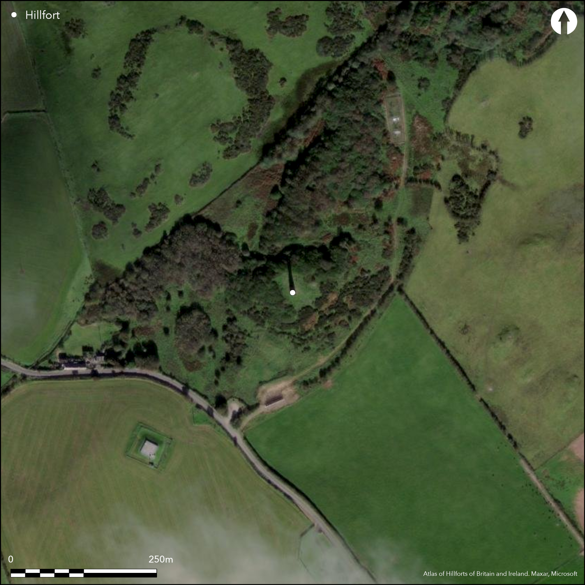
Situated on a small steep-sided hillock forming a local summit, this fort is oval on plan, measuring about 50m from NE to SW by 38m transversely within at least three ramparts, though these are largely reduced to stony scarps and currently can only be seen in the S quarter. Elsewhere the defences are blanketed in thickets of gorse and rhododendrons, which also cover the possible entrance on the NE noted in 1968 by OS surveyors, and the steep outcrops that afforded protection on the NW.
Citizen Science: ✗
Reliability of Data: Confirmed
Reliability of Interpretation: Confirmed
X: -568884 Y: 7349570 (EPSG: 3857)
Longitude: -5.110367483233004 Latitude: 54.93659639478629 (EPSG:4326)
Country: Scotland
Current County or Unitary Authority: Dumfries & Galloway
Historic County: Wigtownshire
Current Parish/Community/Council/Townland: Leswalt
None
| Extant | ✓ |
| Cropmark | ✗ |
| Likely Destroyed | ✗ |
Partly obscured by dense thickets of gorse and rhododendrons, though these had been partly cleared in 2013
| Woodland | ✗ |
| Commercial Forestry Plantation | ✗ |
| Parkland | ✗ |
| Pasture (Grazing) | ✓ |
| Arable | ✗ |
| Scrub/Bracken | ✓ |
| Bare Outcrop | ✗ |
| Heather/Moorland | ✗ |
| Heath | ✗ |
| Built-up | ✗ |
| Coastal Grassland | ✗ |
| Other | ✗ |
None
| Contour Fort | ✓ |
| Partial Contour Fort | ✗ |
| Promontory Fort | ✗ |
| Hillslope Fort | ✗ |
| Level Terrain Fort | ✗ |
| Marsh Fort | ✗ |
| Multiple Enclosure Fort | ✗ |
| Hilltop | ✓ |
| Coastal Promontory | ✗ |
| Inland Promontory | ✗ |
| Valley Bottom | ✗ |
| Knoll/Hillock/Outcrop | ✗ |
| Ridge | ✗ |
| Cliff/Plateau-edge/Scarp | ✗ |
| Hillslope | ✗ |
| Lowland | ✗ |
| Spur | ✗ |
Dominant Topographic Feature: None
| North | ✗ |
| Northeast | ✗ |
| East | ✗ |
| Southeast | ✗ |
| South | ✗ |
| Southwest | ✗ |
| West | ✗ |
| Northwest | ✗ |
| Level | ✓ |
Altitude: 120.0m
N/A
In the absence of excavation, there are neither stratified artefacts nor radiocarbon dates to provide a chronology for the defences.
Reliability: D - None
| Pre 1200BC | ✗ |
| 1200BC - 800BC | ✗ |
| 800BC - 400BC | ✗ |
| 400BC - AD50 | ✗ |
| AD50 - AD400 | ✗ |
| AD400 - AD 800 | ✗ |
| Post AD800 | ✗ |
| Unknown | ✓ |
| Pre Hillfort: | None |
| Post Hillfort: | None |
Apparently depicted on John Aislie' county map of 1782 with two concentric lines, it was shown by OS surveyors in 1847 on the 1st edition of the OS 6-inch map with a single ring of hachures (Wigtownshire 1849, sheet 9). It was surveyed in greater detail for the 1:2500 map in 1893, by which time the monument to Sir Andrew Agnew had been constructed on the summit, along with an access road through the possible entrance on the NE. The fort was described in the County Inventory for Wigtownshire (RCAHMS 1912, 70, No.176), and Scheduled in 1938. It was subsequently visited by RCAHMS in 1953 and 1984, and resurveyed at 1:2500 by the OS in 1968.
| 1st Identified Map Depiction (1782): | John Ainslie 1782 Map of the county of Wigton |
| Other (1847): | Named on the 1st edition OS 6-inch map (Wigtownshire 1849, sheet 9) |
| Earthwork Survey (1893): | 1:2500 OS map (Wigtownshire 1894, sheet 11.5) |
| Other (1911): | Description (RCAHMS 1912, 70, No. 176) |
| Other (1938): | Scheduled |
| Other (1953): | Description during RCAHMS Survey of Marginal Lands |
| Earthwork Survey (1968): | 1:2500 by OS |
| Other (1968): | Resurveyed at 1:2500 by the OS |
| Other (1984): | Description by RCAHMS |
Featureless
None
| None | ✓ |
| Spring | ✗ |
| Stream | ✗ |
| Pool | ✗ |
| Flush | ✗ |
| Well | ✗ |
| Other | ✗ |
None
| No Known Features | ✓ |
| Round Stone Structures | ✗ |
| Rectangular Stone Structures | ✗ |
| Curvilinear Platforms | ✗ |
| Other Roundhouse Evidence | ✗ |
| Pits | ✗ |
| Quarry Hollows | ✗ |
| Other | ✗ |
None
| No Known Excavation | ✓ |
| Pits | ✗ |
| Postholes | ✗ |
| Roundhouses | ✗ |
| Rectangular Structures | ✗ |
| Roads/Tracks | ✗ |
| Quarry Hollows | ✗ |
| Other | ✗ |
| Nothing Found | ✗ |
None
| No Known Geophysics | ✓ |
| Pits | ✗ |
| Roundhouses | ✗ |
| Rectangular Structures | ✗ |
| Roads/Tracks | ✗ |
| Quarry Hollows | ✗ |
| Other | ✗ |
| Nothing Found | ✗ |
None
| No Known Finds | ✓ |
| Pottery | ✗ |
| Metal | ✗ |
| Metalworking | ✗ |
| Human Bones | ✗ |
| Animal Bones | ✗ |
| Lithics | ✗ |
| Environmental | ✗ |
| Other | ✗ |
None
| APs Not Checked | ✗ |
| None | ✓ |
| Roundhouses | ✗ |
| Rectangular Structures | ✗ |
| Pits | ✗ |
| Postholes | ✗ |
| Roads/Tracks | ✗ |
| Other | ✗ |
See main summary
| 1: | None |
| 2: | Possible earlier entrance adopted by the later track built to access the monument on the summit. |
Guard Chambers: ✗
Chevaux de Frise: ✗
| 1. Simple Gap (North east): | None |
At least three ramparts as far as can be detected in dense scrub, and OS surveyors reported a fourth on the S and W
| Area 1: | 0.15ha. |
| Total: | 0.15ha. |
Total Footprint Area: 0.5ha.
None
| ✗ | None |
| ✓ | Precise configuration of the ramparts is obscured by vegetation. |
| NE Quadrant: | 2 |
| SE Quadrant: | 4 |
| SW Quadrant: | 4 |
| NW Quadrant: | 1 |
| Total: | 4 |
| Partial Univallate | ✓ |
| Univallate | ✗ |
| Partial Bivallate | ✓ |
| Bivallate | ✗ |
| Partial Multivallate | ✓ |
| Multivallate | ✗ |
| Unknown | ✗ |
| Partial Univallate | ✗ |
| Univallate | ✗ |
| Partial Bivallate | ✗ |
| Bivallate | ✗ |
| Partial Multivallate | ✗ |
| Multivallate | ✗ |
None
| None | ✗ |
| Earthen Bank | ✗ |
| Stone Wall | ✗ |
| Rubble | ✓ |
| Wall-walk | ✗ |
| Evidence of Timber | ✗ |
| Vitrification | ✗ |
| Other Burning | ✗ |
| Palisade | ✗ |
| Counter Scarp Bank | ✗ |
| Berm | ✗ |
| Unfinished | ✗ |
| Other | ✗ |
None
| None | ✗ |
| Earthen Bank | ✗ |
| Stone Wall | ✗ |
| Murus Duplex | ✗ |
| Timber-framed | ✗ |
| Timber-laced | ✗ |
| Vitrification | ✗ |
| Other Burning | ✗ |
| Palisade | ✗ |
| Counter Scarp Bank | ✗ |
| Berm | ✗ |
| Unfinished | ✗ |
| No Known Excavation | ✓ |
| Other | ✗ |
| ✗ | None |
| ✗ | None |
Number of Ditches: None
| ✗ | None |
RCAHMS (1912) The Royal Commission on the Ancient and Historical Monuments and Constructions of Scotland. Fourth report and inventory of monuments and constructions in Galloway, 1, County of Wigtown, Edinburgh.
Atlas of Hillforts:
Wikidata:
This work is licensed under CC BY-SA 4.0![]()
![]()
![]() and should be cited as:
and should be cited as:
Lock, Gary and Ralston, Ian. 2024. Atlas of Hillforts of Britain and Ireland. Available at: https://hillforts.arch.ox.ac.uk
Document Version 1.1