LiDAR 1m DTM Hillshade
Satellite Imagery
LiDAR 1m DTM Hillshade
Satellite Imagery
Scroll left/right to view further images.
HER: Dumfries & Galloway MDG1098 (None)
NMR: NX 13 NW 6 (61024)
SM: 1981
NGR: NX 1243 3686
X: 212430 Y: 536860 (OSGB36)
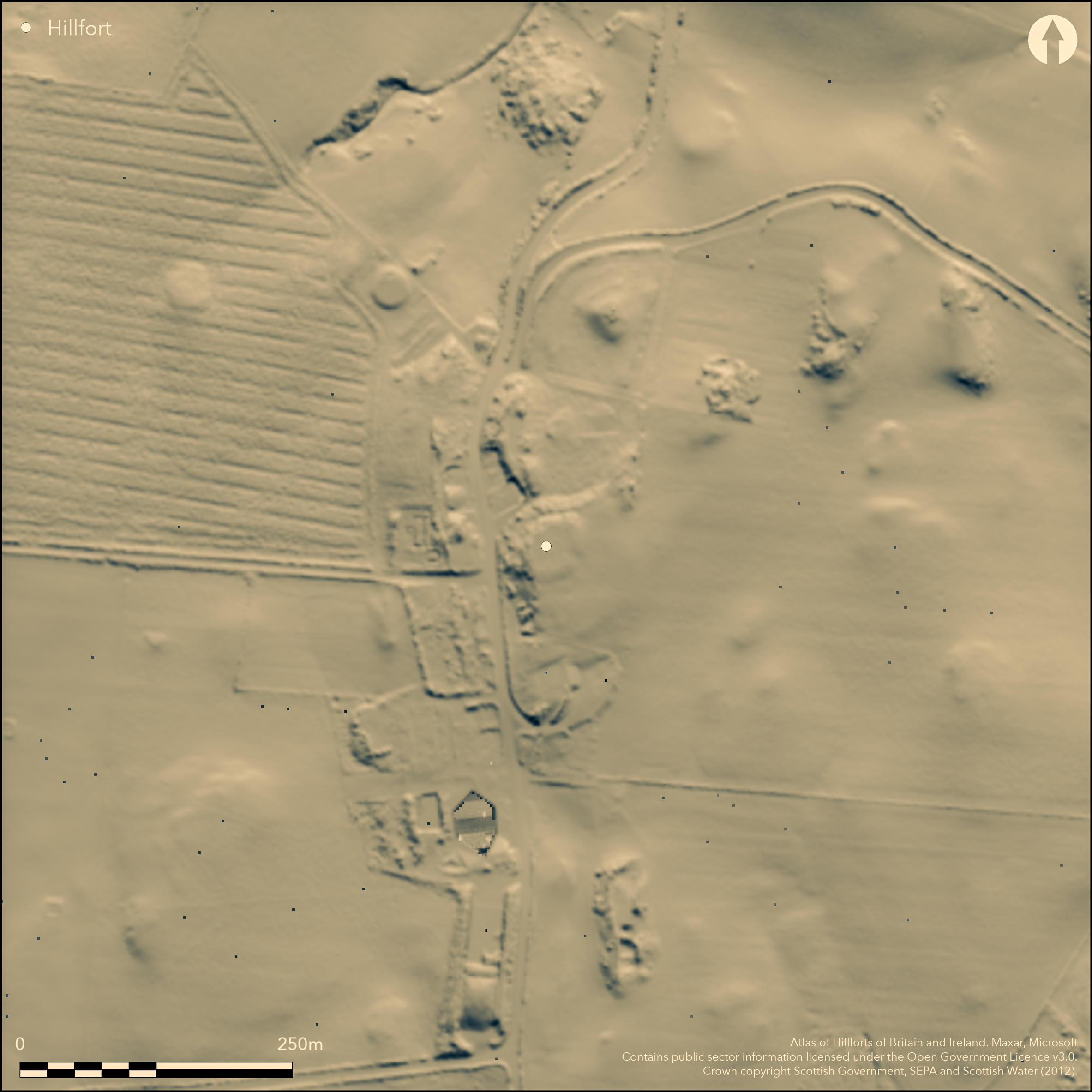
This fort encloses the summit of Core Hill, a local high-point lying immediately S of Kirkmaiden churchyard. Its defences comprise up to four ramparts accompanied by ditches, but all are severely denuded and only the innermost forms a complete circuit, enclosing an oval area measuring 28.3m from NNE to SSW by 21m transversely (0.05ha). On the N this rampart has been reduced to a scarp up to 2.3m in height, while elsewhere it forms a low bank measuring a maximum of 3.4m in thickness by no more than 0.5m in height. Evidence of an external ditch up to 4.5m in breadth by 0.3m in depth can be seen on the SSW and NE, continuing round the N side of the hill as a level terrace cut into the slope. The outer ramparts are visible only on the SSW, currently clothed in dense thickets of gorse, and while they may not have extended along the steep W flank of the hillock, they have probably been ploughed out around the gentler E flank; indeed in 1911 Alexander Curle of RCAHMS noted traces of two ramparts immediately adjacent to the churchyard wall. The first of the outer ramparts on the SSW is 3.4m in thickness by 0.8m in height, and the second 4.2m by 0.6m; the ditch between them is 4.5m broad by 0.5m deep. Another ditch and rampart of similar proportions lie outside them. On the E a gap in the innermost rampart possibly marks the position of an entrance.
Citizen Science: ✗
Reliability of Data: Confirmed
Reliability of Interpretation: Confirmed
X: -546786 Y: 7302271 (EPSG: 3857)
Longitude: -4.911864421077987 Latitude: 54.69176064921413 (EPSG:4326)
Country: Scotland
Current County or Unitary Authority: Dumfries & Galloway
Historic County: Wigtownshire
Current Parish/Community/Council/Townland: Kirkmaiden
The full extent of the outer ramparts is unknown and parts of their circuits have been severely degraded.
| Extant | ✓ |
| Cropmark | ✗ |
| Likely Destroyed | ✗ |
None
| Woodland | ✗ |
| Commercial Forestry Plantation | ✗ |
| Parkland | ✗ |
| Pasture (Grazing) | ✓ |
| Arable | ✗ |
| Scrub/Bracken | ✓ |
| Bare Outcrop | ✗ |
| Heather/Moorland | ✗ |
| Heath | ✗ |
| Built-up | ✗ |
| Coastal Grassland | ✗ |
| Other | ✗ |
Hillock forming local summit.
| Contour Fort | ✓ |
| Partial Contour Fort | ✗ |
| Promontory Fort | ✗ |
| Hillslope Fort | ✗ |
| Level Terrain Fort | ✗ |
| Marsh Fort | ✗ |
| Multiple Enclosure Fort | ✗ |
| Hilltop | ✓ |
| Coastal Promontory | ✗ |
| Inland Promontory | ✗ |
| Valley Bottom | ✗ |
| Knoll/Hillock/Outcrop | ✓ |
| Ridge | ✗ |
| Cliff/Plateau-edge/Scarp | ✗ |
| Hillslope | ✗ |
| Lowland | ✗ |
| Spur | ✗ |
Dominant Topographic Feature: None
| North | ✗ |
| Northeast | ✗ |
| East | ✗ |
| Southeast | ✗ |
| South | ✗ |
| Southwest | ✗ |
| West | ✗ |
| Northwest | ✗ |
| Level | ✓ |
Altitude: 90.0m
N/A
In the absence of excavation, there are neither stratified artefacts nor radiocarbon dates to provide a chronology for the defences.
Reliability: D - None
| Pre 1200BC | ✗ |
| 1200BC - 800BC | ✗ |
| 800BC - 400BC | ✗ |
| 400BC - AD50 | ✗ |
| AD50 - AD400 | ✗ |
| AD400 - AD 800 | ✗ |
| Post AD800 | ✗ |
| Unknown | ✓ |
| Pre Hillfort: | Stone Axe found when the interior was levelled in the 19th century. |
| Post Hillfort: | Ploughed down and degraded by livestock. |
Surveyed at 1:10,560 by the OS in 1848, it was first depicted with its outworks, but these were presumably overgrown by the time it was re-surveyed at 1:2500 in 1894. A description was prepared for the County Inventory for Wigtownshire in 1911 (RCAHMS 1912, 53-4, No. 141), and it was Scheduled in 1939. It was subsequently planned by RCAHMS in 1955, at which time pigs were penned on the site, and revisited in 1984, when the outer defences were extensively overgrown again. The OS resurveyed the fort at 1:2500 in 1972.
| 1st Identified Map Depiction (1848): | Annotated Fort on the 1st edition OS 6-inch map (Wigtownshire 1850, sheet 33) |
| Earthwork Survey (1894): | 1:2500 (Wigtownshire 1895, sheet 33.10) |
| Other (1911): | Description (RCAHMS 1912, 53-4, No. 141) |
| Other (1939): | Scheduled |
| Earthwork Survey (1955): | 1:300 (RCAHMS DP151604) |
| Other (1972): | Resurveyed at 1:2500 by the OS |
| Other (1984): | Description by RCAHMS |
Featureless
None
| None | ✓ |
| Spring | ✗ |
| Stream | ✗ |
| Pool | ✗ |
| Flush | ✗ |
| Well | ✗ |
| Other | ✗ |
None
| No Known Features | ✓ |
| Round Stone Structures | ✗ |
| Rectangular Stone Structures | ✗ |
| Curvilinear Platforms | ✗ |
| Other Roundhouse Evidence | ✗ |
| Pits | ✗ |
| Quarry Hollows | ✗ |
| Other | ✗ |
None
| No Known Excavation | ✓ |
| Pits | ✗ |
| Postholes | ✗ |
| Roundhouses | ✗ |
| Rectangular Structures | ✗ |
| Roads/Tracks | ✗ |
| Quarry Hollows | ✗ |
| Other | ✗ |
| Nothing Found | ✗ |
None
| No Known Geophysics | ✓ |
| Pits | ✗ |
| Roundhouses | ✗ |
| Rectangular Structures | ✗ |
| Roads/Tracks | ✗ |
| Quarry Hollows | ✗ |
| Other | ✗ |
| Nothing Found | ✗ |
Stone axe found in the interior (Maxwell 1885)
| No Known Finds | ✗ |
| Pottery | ✗ |
| Metal | ✗ |
| Metalworking | ✗ |
| Human Bones | ✗ |
| Animal Bones | ✗ |
| Lithics | ✗ |
| Environmental | ✗ |
| Other | ✓ |
None
| APs Not Checked | ✗ |
| None | ✓ |
| Roundhouses | ✗ |
| Rectangular Structures | ✗ |
| Pits | ✗ |
| Postholes | ✗ |
| Roads/Tracks | ✗ |
| Other | ✗ |
See main summary
| 1: | None |
| 2: | No other gaps are visible |
Guard Chambers: ✗
Chevaux de Frise: ✗
| 1. Simple Gap (East): | Innermost circuit only. |
Up to four ramparts with ditches
| Area 1: | 0.05ha. |
| Total: | 0.05ha. |
Total Footprint Area: Noneha.
None
| ✗ | The whole footprint of the visible remains is about 0.2ha, but may be as much as 0.4ha if the outer defences are projected around the E side of the hillock. |
| ✓ | Innermost is complete, but outer defences probably did not extend along W flank |
| NE Quadrant: | 1 |
| SE Quadrant: | 1 |
| SW Quadrant: | 4 |
| NW Quadrant: | 1 |
| Total: | 4 |
| Partial Univallate | ✓ |
| Univallate | ✗ |
| Partial Bivallate | ✗ |
| Bivallate | ✗ |
| Partial Multivallate | ✓ |
| Multivallate | ✗ |
| Unknown | ✗ |
| Partial Univallate | ✗ |
| Univallate | ✗ |
| Partial Bivallate | ✗ |
| Bivallate | ✗ |
| Partial Multivallate | ✗ |
| Multivallate | ✗ |
None
| None | ✗ |
| Earthen Bank | ✓ |
| Stone Wall | ✗ |
| Rubble | ✗ |
| Wall-walk | ✗ |
| Evidence of Timber | ✗ |
| Vitrification | ✗ |
| Other Burning | ✗ |
| Palisade | ✗ |
| Counter Scarp Bank | ✗ |
| Berm | ✗ |
| Unfinished | ✗ |
| Other | ✗ |
None
| None | ✗ |
| Earthen Bank | ✗ |
| Stone Wall | ✗ |
| Murus Duplex | ✗ |
| Timber-framed | ✗ |
| Timber-laced | ✗ |
| Vitrification | ✗ |
| Other Burning | ✗ |
| Palisade | ✗ |
| Counter Scarp Bank | ✗ |
| Berm | ✗ |
| Unfinished | ✗ |
| No Known Excavation | ✓ |
| Other | ✗ |
| ✗ | None |
| ✓ | None |
Number of Ditches: 3
| ✗ | None |
Maxwell, H E (1885) 'Ancient weapons, instruments, utensils and ornaments of Wigtonshire. With list of the principal stone implements recorded from Wigtonshire', Archaeol Hist Collect Ayrshire Galloway 5, 21-55
RCAHMS (1912) The Royal Commission on the Ancient and Historical Monuments and Constructions of Scotland. Fourth report and inventory of monuments and constructions in Galloway, 1, county of Wigtown, Edinburgh
Atlas of Hillforts:
Wikidata:
This work is licensed under CC BY-SA 4.0![]()
![]()
![]() and should be cited as:
and should be cited as:
Lock, Gary and Ralston, Ian. 2024. Atlas of Hillforts of Britain and Ireland. Available at: https://hillforts.arch.ox.ac.uk
Document Version 1.1