Satellite Imagery
Satellite Imagery
HER: Dumfries & Galloway MDG1121 (None)
NMR: NX 13 SW 13 (61047)
SM: 1976
NGR: NX 1306 3107
X: 213060 Y: 531070 (OSGB36)
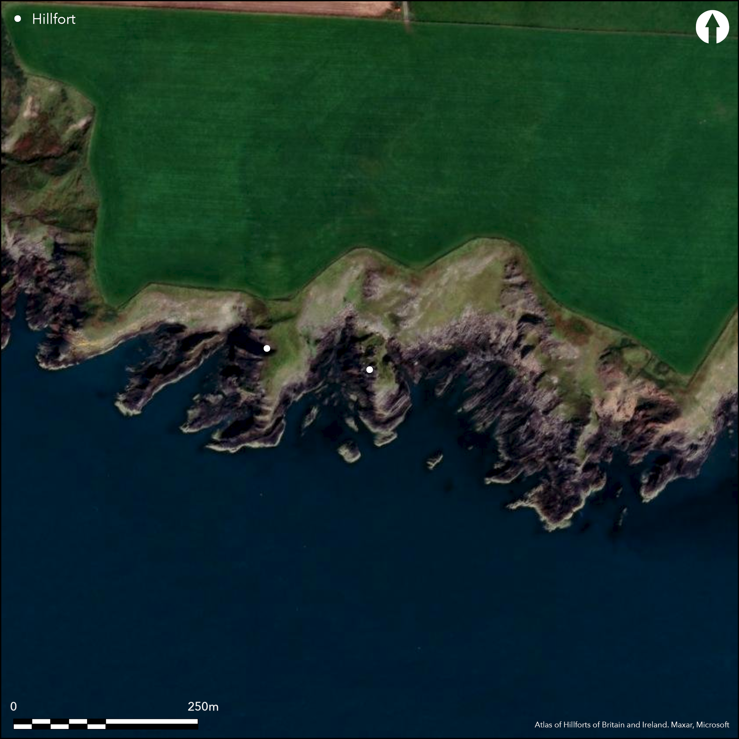
The promontory known as Dunorroch, which juts into the sea from the foot of the coastal cliffs, is little more than a bare jagged rock outcrop. The promontory measures 45m in length overall, rising sheer on the W to a jagged spine, and descending steeply on the E, so much so that the only usable space comprises one small terrace above the neck on the N, and another on the E. The leading edge of the terrace on the N is skirted for a distance of 14m by a wall at least 2.4m thick, which cuts back sharply at the NE corner to run along the edge of the cliffs on the E; on the N the outer face of this wall stands to a maximum height of 1.8m in nine courses, and its crest is up to 3m above the external ground level on the neck. There are also traces of a similar wall along the edge of the terrace on the E side of the promontory, and at one point here the face stands 1.2m high in six courses from rock outcrops 2.8m below the lip of the terrace. This sector of the wall ends abruptly against a rock outcrop, but some 9m to the WSW there is another fragment of masonry cutting across the S end of the promontory. Conceivably this latter might relate to some form of inner enclosure taking in the pinnacle of the rock outcrop, but the remains are too fragmentary to be certain of their original configuration. The entrance probably lay at the NE corner of the terrace on the N; it is 2.5m wide but currently blocked by a massive boulder. A circular foundation noted by Wilson probably refers to the rock outcrops on the crest of the promontory at the S end of the fort; Wilson also mentions that Dr Trotter found one or two spindle whorls and a piece of pottery with a hole through it (see Maxwell 1885, 33, fig. 24) within the interior.
Citizen Science: ✗
Reliability of Data: Confirmed
Reliability of Interpretation: Confirmed
X: -545287 Y: 7292314 (EPSG: 3857)
Longitude: -4.898397891638133 Latitude: 54.64002786882778 (EPSG:4326)
Country: Scotland
Current County or Unitary Authority: Dumfries & Galloway
Historic County: Wigtownshire
Current Parish/Community/Council/Townland: Kirkmaiden
None
| Extant | ✓ |
| Cropmark | ✗ |
| Likely Destroyed | ✗ |
None
| Woodland | ✗ |
| Commercial Forestry Plantation | ✗ |
| Parkland | ✗ |
| Pasture (Grazing) | ✗ |
| Arable | ✗ |
| Scrub/Bracken | ✗ |
| Bare Outcrop | ✗ |
| Heather/Moorland | ✗ |
| Heath | ✗ |
| Built-up | ✗ |
| Coastal Grassland | ✓ |
| Other | ✗ |
None
| Contour Fort | ✗ |
| Partial Contour Fort | ✗ |
| Promontory Fort | ✓ |
| Hillslope Fort | ✗ |
| Level Terrain Fort | ✗ |
| Marsh Fort | ✗ |
| Multiple Enclosure Fort | ✗ |
| Hilltop | ✗ |
| Coastal Promontory | ✓ |
| Inland Promontory | ✗ |
| Valley Bottom | ✗ |
| Knoll/Hillock/Outcrop | ✗ |
| Ridge | ✗ |
| Cliff/Plateau-edge/Scarp | ✗ |
| Hillslope | ✗ |
| Lowland | ✗ |
| Spur | ✗ |
Dominant Topographic Feature: None
| North | ✗ |
| Northeast | ✗ |
| East | ✗ |
| Southeast | ✗ |
| South | ✗ |
| Southwest | ✗ |
| West | ✗ |
| Northwest | ✗ |
| Level | ✓ |
Altitude: 5.0m
N/A
In the absence of modern excavation, there are neither stratified artefacts nor radiocarbon dates to provide a chronology for the defences.
Reliability: D - None
| Pre 1200BC | ✗ |
| 1200BC - 800BC | ✗ |
| 800BC - 400BC | ✗ |
| 400BC - AD50 | ✗ |
| AD50 - AD400 | ✗ |
| AD400 - AD 800 | ✗ |
| Post AD800 | ✗ |
| Unknown | ✓ |
| Pre Hillfort: | None |
| Post Hillfort: | None |
Noted by George Wilson in 1881, Dunorroch is depicted in 1894 on the 25-inch map (Wigtownshire 1895, sheet 37.11), and in 1911 described in the County Inventory for Wigtownshire (RCAHMS 1912, 56, No. 145). It was Scheduled in 1938, and visited subsequently by RCAHMS in 1951 and 1984, and by the OS in 1972.
| 1st Identified Written Reference (1881): | George Wilson in Maxwell 1885, 33 |
| Excavation (1881): | By Dr Trotter (Wilson Manuscript notes RCAHMS 1912, 56, No. 145) |
| 1st Identified Map Depiction (1894): | Annotated Fort on the OS 25-inch map (Wigtownshire 1895, sheet 37.11) |
| Other (1911): | Description (RCAHMS 1912, 56, No. 145) |
| Other (1938): | Scheduled |
| Other (1951): | Description during RCAHMS Survey of Marginal Lands |
| Other (1972): | Revised at 1:2500 by the OS |
| Other (1984): | Description by RCAHMS |
| Other (2014): | Visit by S Halliday in preparation for the Hillfort Study Group meeting |
Featureless
None
| None | ✓ |
| Spring | ✗ |
| Stream | ✗ |
| Pool | ✗ |
| Flush | ✗ |
| Well | ✗ |
| Other | ✗ |
None
| No Known Features | ✓ |
| Round Stone Structures | ✗ |
| Rectangular Stone Structures | ✗ |
| Curvilinear Platforms | ✗ |
| Other Roundhouse Evidence | ✗ |
| Pits | ✗ |
| Quarry Hollows | ✗ |
| Other | ✗ |
None
| No Known Excavation | ✓ |
| Pits | ✗ |
| Postholes | ✗ |
| Roundhouses | ✗ |
| Rectangular Structures | ✗ |
| Roads/Tracks | ✗ |
| Quarry Hollows | ✗ |
| Other | ✗ |
| Nothing Found | ✗ |
None
| No Known Geophysics | ✓ |
| Pits | ✗ |
| Roundhouses | ✗ |
| Rectangular Structures | ✗ |
| Roads/Tracks | ✗ |
| Quarry Hollows | ✗ |
| Other | ✗ |
| Nothing Found | ✗ |
Spindle whorls and a perforated piece of fired clay reported as a result of diggings in 1881 (Maxwell 1885, 33, fig. 24)
| No Known Finds | ✗ |
| Pottery | ✓ |
| Metal | ✗ |
| Metalworking | ✗ |
| Human Bones | ✗ |
| Animal Bones | ✗ |
| Lithics | ✓ |
| Environmental | ✗ |
| Other | ✗ |
None
| APs Not Checked | ✗ |
| None | ✓ |
| Roundhouses | ✗ |
| Rectangular Structures | ✗ |
| Pits | ✗ |
| Postholes | ✗ |
| Roads/Tracks | ✗ |
| Other | ✗ |
See main summary
| 1: | None |
| 2: | None |
Guard Chambers: ✗
Chevaux de Frise: ✗
| 1. Simple Gap (North east): | None |
Single wall cutting off an inhospitable and difficult promontory of jagged rock descending across bare outcrops down to the sea.
| Area 1: | 0.08ha. |
| Total: | 0.08ha. |
Total Footprint Area: Noneha.
None
| ✗ | Very small and almost unmeasurable |
| ✗ | None |
| NE Quadrant: | 1 |
| SE Quadrant: | 1 |
| SW Quadrant: | 0 |
| NW Quadrant: | 0 |
| Total: | 1 |
| Partial Univallate | ✓ |
| Univallate | ✗ |
| Partial Bivallate | ✗ |
| Bivallate | ✗ |
| Partial Multivallate | ✗ |
| Multivallate | ✗ |
| Unknown | ✗ |
| Partial Univallate | ✗ |
| Univallate | ✗ |
| Partial Bivallate | ✗ |
| Bivallate | ✗ |
| Partial Multivallate | ✗ |
| Multivallate | ✗ |
None
| None | ✗ |
| Earthen Bank | ✗ |
| Stone Wall | ✓ |
| Rubble | ✗ |
| Wall-walk | ✗ |
| Evidence of Timber | ✗ |
| Vitrification | ✗ |
| Other Burning | ✗ |
| Palisade | ✗ |
| Counter Scarp Bank | ✗ |
| Berm | ✗ |
| Unfinished | ✗ |
| Other | ✗ |
None
| None | ✗ |
| Earthen Bank | ✗ |
| Stone Wall | ✗ |
| Murus Duplex | ✗ |
| Timber-framed | ✗ |
| Timber-laced | ✗ |
| Vitrification | ✗ |
| Other Burning | ✗ |
| Palisade | ✗ |
| Counter Scarp Bank | ✗ |
| Berm | ✗ |
| Unfinished | ✗ |
| No Known Excavation | ✓ |
| Other | ✗ |
| ✗ | None |
| ✗ | None |
Number of Ditches: None
| ✗ | None |
Maxwell, H E (1885) 'Ancient weapons, instruments, utensils and ornaments of Wigtonshire. With list of the principal stone implements recorded from Wigtonshire', Archaeol Hist Collect Ayrshire Galloway 5
RCAHMS (1912) The Royal Commission on the Ancient and Historical Monuments and Constructions of Scotland. Fourth report and inventory of monuments and constructions in Galloway, 1, county of Wigtown, Edinburgh
Atlas of Hillforts:
Wikidata:
This work is licensed under CC BY-SA 4.0![]()
![]()
![]() and should be cited as:
and should be cited as:
Lock, Gary and Ralston, Ian. 2024. Atlas of Hillforts of Britain and Ireland. Available at: https://hillforts.arch.ox.ac.uk
Document Version 1.1