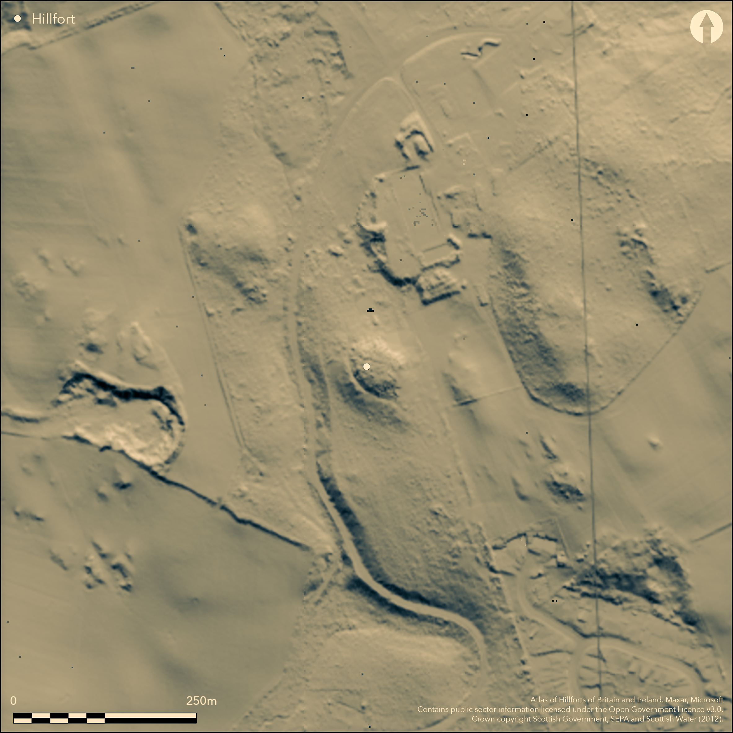
LiDAR 1m DTM Hillshade

Satellite Imagery
LiDAR 1m DTM Hillshade
Satellite Imagery
Scroll left/right to view further images.
HER: Dumfries & Galloway MDG1308 (None)
NMR: NX 15 NW 4 (61250)
SM: 1995
NGR: NX 1483 5795
X: 214830 Y: 557950 (OSGB36)
What may be a fortified enclosure occupies the Round Dounan, a low hillock within the policies of Dunragit House. Oval on plan the summit of the hillock measures about 28m from NW to SE by 25m transversely, and according to R C Reid (1952) it is enclosed by a stone wall, though no trace of this feature has been noted since; Reid also identified an outer rampart extending round the foot of the hillock, where the principal feature visible is a terrace some 5m broad on the W. To some extent the identification of this enclosure as a fort rests on the derivation of the name Dunragit from 'Fort of Rheged', an attribution that has been employed to suggest a date for the occupation of the Round Dounan in the 5th-6th centuries AD (most recently discussed by McCarthy 2002). Typologically, however, the appearance of the earthworks have more in common with the form of a medieval motte fashioned from a natural knoll.
Citizen Science: ✗
Reliability of Data: Confirmed
Reliability of Interpretation: Unconfirmed
X: -544146 Y: 7338986 (EPSG: 3857)
Longitude: -4.888147712699394 Latitude: 54.881937879834474 (EPSG:4326)
Country: Scotland
Current County or Unitary Authority: Dumfries & Galloway
Historic County: Wigtownshire
Current Parish/Community/Council/Townland: Old Luce
None
| Extant | ✓ |
| Cropmark | ✗ |
| Likely Destroyed | ✗ |
None
| Woodland | ✓ |
| Commercial Forestry Plantation | ✗ |
| Parkland | ✗ |
| Pasture (Grazing) | ✗ |
| Arable | ✗ |
| Scrub/Bracken | ✓ |
| Bare Outcrop | ✗ |
| Heather/Moorland | ✗ |
| Heath | ✗ |
| Built-up | ✗ |
| Coastal Grassland | ✗ |
| Other | ✗ |
None
| Contour Fort | ✓ |
| Partial Contour Fort | ✗ |
| Promontory Fort | ✗ |
| Hillslope Fort | ✗ |
| Level Terrain Fort | ✗ |
| Marsh Fort | ✗ |
| Multiple Enclosure Fort | ✗ |
| Hilltop | ✗ |
| Coastal Promontory | ✗ |
| Inland Promontory | ✗ |
| Valley Bottom | ✗ |
| Knoll/Hillock/Outcrop | ✓ |
| Ridge | ✗ |
| Cliff/Plateau-edge/Scarp | ✗ |
| Hillslope | ✗ |
| Lowland | ✗ |
| Spur | ✗ |
Dominant Topographic Feature: None
| North | ✗ |
| Northeast | ✗ |
| East | ✗ |
| Southeast | ✗ |
| South | ✗ |
| Southwest | ✗ |
| West | ✗ |
| Northwest | ✗ |
| Level | ✓ |
Altitude: 60.0m
N/A
The date of this work is unknown, but it is often claimed as an early medieval fort but largely on the strength of its place name.
Reliability: D - None
| Pre 1200BC | ✗ |
| 1200BC - 800BC | ✗ |
| 800BC - 400BC | ✗ |
| 400BC - AD50 | ✗ |
| AD50 - AD400 | ✗ |
| AD400 - AD 800 | ✓ |
| Post AD800 | ✗ |
| Unknown | ✓ |
| Pre Hillfort: | None |
| Post Hillfort: | None |
| Other: | Placename attribution |
Depicted in 1847 on the 1st edition of the OS 6-inch map (Wigtownshire 1850, sheet 17) as a hachured mound within the woodland of the policies, and criss-crossed by several tracks, it is shown in a little more detail on the first 25-inch map (1894, sheet 18.7), and briefly described in the RCAHMS County Inventory of Wigtownshire (1912, 114, No. 312). R C Reid produced a plan and section in 1951, though this does not show many of the features he describes, including an entrance, where there were supposedly inner and outer gates and a thickening of the inner wall. It was resurveyed by the OS at 1:2500 in 1968, and in 1986 revisited by RCAHMS.
| 1st Identified Map Depiction (1847): | Depicted but not as an antiquity on the OS 6-inch map (Wigtownshire 1850, sheet 17) |
| Other (1894): | Named in Gothic type on the OS 25-inch map (Wigtownshire 1894, sheet 18.7) |
| Other (1911): | Description (RCAHMS 1912, 114, No. 312) |
| Earthwork Survey (1951): | Reid 1952 |
| Other (1968): | Resurveyed at 1:2500 by the OS |
| Other (1986): | Description by RCAHMS |
| Other (1994): | Scheduled |
Featureless
None
| None | ✓ |
| Spring | ✗ |
| Stream | ✗ |
| Pool | ✗ |
| Flush | ✗ |
| Well | ✗ |
| Other | ✗ |
None
| No Known Features | ✓ |
| Round Stone Structures | ✗ |
| Rectangular Stone Structures | ✗ |
| Curvilinear Platforms | ✗ |
| Other Roundhouse Evidence | ✗ |
| Pits | ✗ |
| Quarry Hollows | ✗ |
| Other | ✗ |
None
| No Known Excavation | ✓ |
| Pits | ✗ |
| Postholes | ✗ |
| Roundhouses | ✗ |
| Rectangular Structures | ✗ |
| Roads/Tracks | ✗ |
| Quarry Hollows | ✗ |
| Other | ✗ |
| Nothing Found | ✗ |
None
| No Known Geophysics | ✓ |
| Pits | ✗ |
| Roundhouses | ✗ |
| Rectangular Structures | ✗ |
| Roads/Tracks | ✗ |
| Quarry Hollows | ✗ |
| Other | ✗ |
| Nothing Found | ✗ |
None
| No Known Finds | ✓ |
| Pottery | ✗ |
| Metal | ✗ |
| Metalworking | ✗ |
| Human Bones | ✗ |
| Animal Bones | ✗ |
| Lithics | ✗ |
| Environmental | ✗ |
| Other | ✗ |
None
| APs Not Checked | ✗ |
| None | ✓ |
| Roundhouses | ✗ |
| Rectangular Structures | ✗ |
| Pits | ✗ |
| Postholes | ✗ |
| Roads/Tracks | ✗ |
| Other | ✗ |
See main summary
| 0: | No clear breaks |
| 2: | None known |
Guard Chambers: ✗
Chevaux de Frise: ✗
Supposedly an inner wall and an outer rampart, but nothing very coherent is visible on the ground.
| Area 1: | 0.05ha. |
| Total: | 0.05ha. |
Total Footprint Area: Noneha.
None
| ✗ | None |
| ✓ | The inner probably encloses the whole of the summit |
| NE Quadrant: | 1 |
| SE Quadrant: | 2 |
| SW Quadrant: | 2 |
| NW Quadrant: | 2 |
| Total: | 2 |
| Partial Univallate | ✓ |
| Univallate | ✗ |
| Partial Bivallate | ✓ |
| Bivallate | ✗ |
| Partial Multivallate | ✗ |
| Multivallate | ✗ |
| Unknown | ✗ |
| Partial Univallate | ✗ |
| Univallate | ✗ |
| Partial Bivallate | ✗ |
| Bivallate | ✗ |
| Partial Multivallate | ✗ |
| Multivallate | ✗ |
None
| None | ✓ |
| Earthen Bank | ✗ |
| Stone Wall | ✗ |
| Rubble | ✗ |
| Wall-walk | ✗ |
| Evidence of Timber | ✗ |
| Vitrification | ✗ |
| Other Burning | ✗ |
| Palisade | ✗ |
| Counter Scarp Bank | ✗ |
| Berm | ✗ |
| Unfinished | ✗ |
| Other | ✗ |
None
| None | ✗ |
| Earthen Bank | ✗ |
| Stone Wall | ✓ |
| Murus Duplex | ✗ |
| Timber-framed | ✗ |
| Timber-laced | ✗ |
| Vitrification | ✗ |
| Other Burning | ✗ |
| Palisade | ✗ |
| Counter Scarp Bank | ✗ |
| Berm | ✗ |
| Unfinished | ✗ |
| No Known Excavation | ✗ |
| Other | ✗ |
| ✗ | None |
| ✗ | None |
Number of Ditches: None
| ✗ | None |
McCarthy, M 2002 'Rheged: and early historic kingdom near the Solway'. Proc Soc Antiq Scot 132, 357-81
RCAHMS (1912) The Royal Commission on the Ancient and Historical Monuments and Constructions of Scotland. Fourth report and inventory of monuments and constructions in Galloway, 1, county of Wigtown, Edinburgh
Reid, R C (1952) 'Dunragit', Trans Dumfriesshire Galloway Natur Hist Antiq Soc, 3rd Ser, 29, 155-6.
Atlas of Hillforts:
Wikidata:
This work is licensed under CC BY-SA 4.0![]()
![]()
![]() and should be cited as:
and should be cited as:
Lock, Gary and Ralston, Ian. 2024. Atlas of Hillforts of Britain and Ireland. Available at: https://hillforts.arch.ox.ac.uk
Document Version 1.1