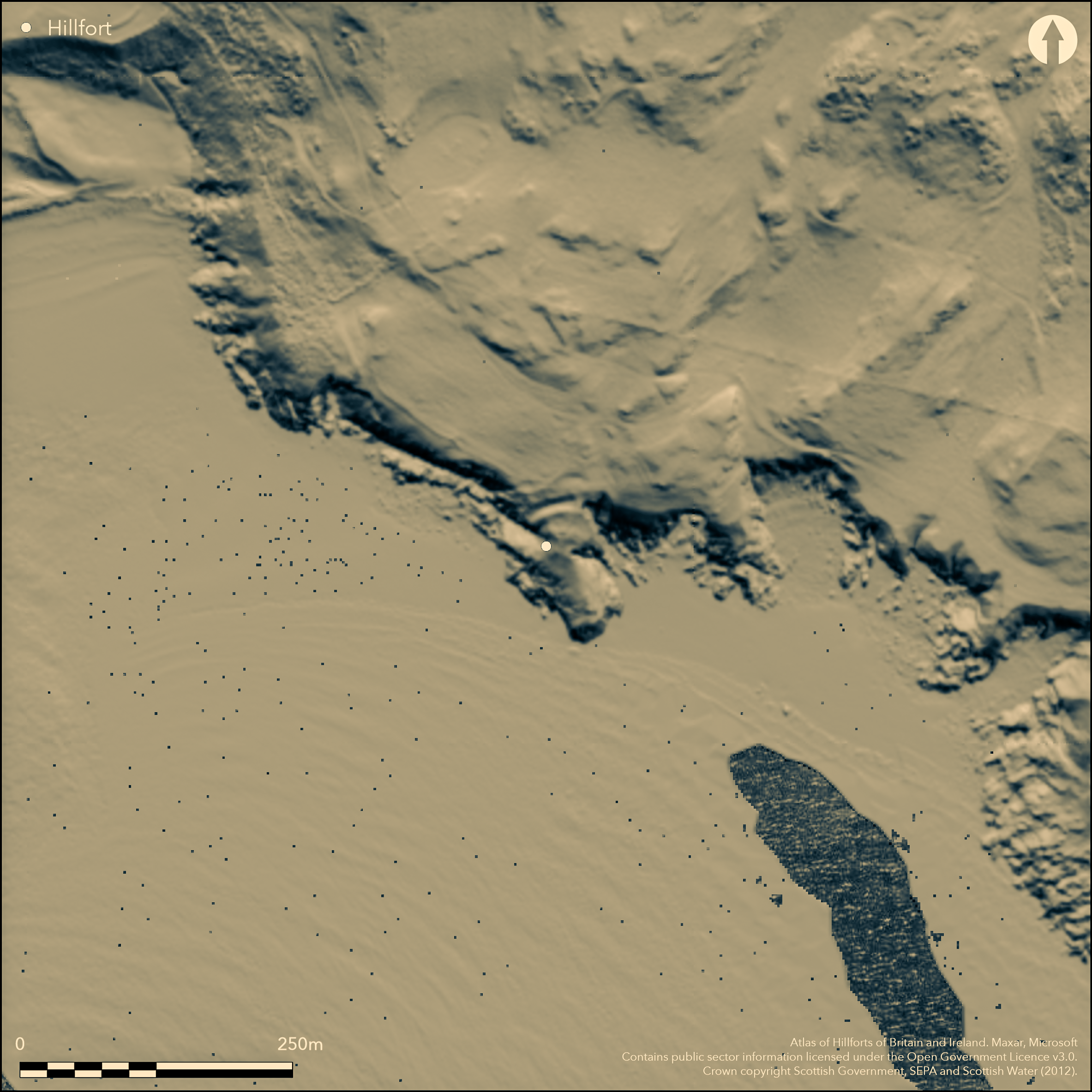
LiDAR 1m DTM Hillshade
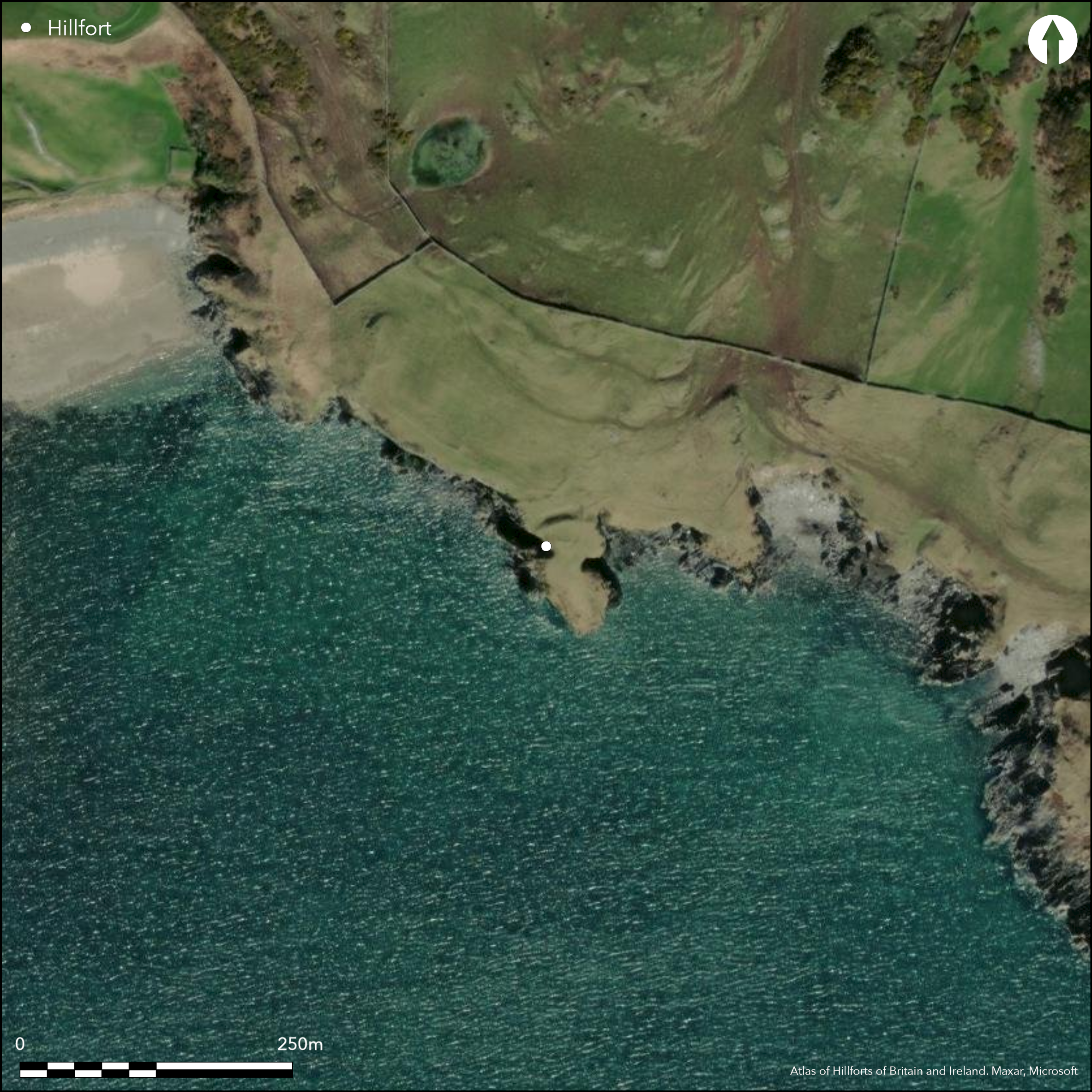
Satellite Imagery
LiDAR 1m DTM Hillshade
Satellite Imagery
Scroll left/right to view further images.
HER: Dumfries & Galloway MDG2339 (None)
NMR: NX 33 NE 2 (62667)
SM: 1979
NGR: NX 3696 3932
X: 236960 Y: 539320 (OSGB36)
This promontory work occupies a precipitous position on the cliffs along the SW coast of the Machars and is undercut by sea caves, the mouths of which have probably receded back into the top of the promontory since its construction. The defences, which cut off the approach from the N, comprise a stone wall some 2.4m thick where the faces survive, fronted with a ditch about 8.5m in breadth by up to 2.5m in depth externally. A causeway towards the E side of the promontory corresponds to an entrance 1.5m wide through the wall to provide access into the interior, which measures 56m from N to S by up to 23m transversely (0.1ha); the way the arc of defences meets the cliff-edge on the landward side a cleft above one of the sea caves suggests that the interior was once larger, but probably never more than about 0.13ha. The foundations of several structures can be seen in the immediate rear of the wall, and in 1955 RCAHMS speculated that these and the wall itself might be the result of a secondary occupation.
Citizen Science: ✗
Reliability of Data: Confirmed
Reliability of Interpretation: Confirmed
X: -504620 Y: 7308173 (EPSG: 3857)
Longitude: -4.533076396631272 Latitude: 54.72238955587687 (EPSG:4326)
Country: Scotland
Current County or Unitary Authority: Dumfries & Galloway
Historic County: Wigtownshire
Current Parish/Community/Council/Townland: Glasserton
None
| Extant | ✓ |
| Cropmark | ✗ |
| Likely Destroyed | ✗ |
None
| Woodland | ✗ |
| Commercial Forestry Plantation | ✗ |
| Parkland | ✗ |
| Pasture (Grazing) | ✓ |
| Arable | ✗ |
| Scrub/Bracken | ✗ |
| Bare Outcrop | ✗ |
| Heather/Moorland | ✗ |
| Heath | ✗ |
| Built-up | ✗ |
| Coastal Grassland | ✓ |
| Other | ✗ |
None
| Contour Fort | ✗ |
| Partial Contour Fort | ✗ |
| Promontory Fort | ✓ |
| Hillslope Fort | ✗ |
| Level Terrain Fort | ✗ |
| Marsh Fort | ✗ |
| Multiple Enclosure Fort | ✗ |
| Hilltop | ✗ |
| Coastal Promontory | ✓ |
| Inland Promontory | ✗ |
| Valley Bottom | ✗ |
| Knoll/Hillock/Outcrop | ✗ |
| Ridge | ✗ |
| Cliff/Plateau-edge/Scarp | ✗ |
| Hillslope | ✗ |
| Lowland | ✗ |
| Spur | ✗ |
Dominant Topographic Feature: None
| North | ✗ |
| Northeast | ✗ |
| East | ✗ |
| Southeast | ✗ |
| South | ✗ |
| Southwest | ✗ |
| West | ✗ |
| Northwest | ✗ |
| Level | ✓ |
Altitude: 30.0m
N/A
In the absence of excavation, there are neither stratified artefacts nor radiocarbon dates to provide a chronology for the defences.
Reliability: D - None
| Pre 1200BC | ✗ |
| 1200BC - 800BC | ✗ |
| 800BC - 400BC | ✗ |
| 400BC - AD50 | ✗ |
| AD50 - AD400 | ✗ |
| AD400 - AD 800 | ✗ |
| Post AD800 | ✓ |
| Unknown | ✓ |
| Pre Hillfort: | None |
| Post Hillfort: | Angular foundations in the interior may relate to a medieval occupationn |
First surveyed in 1849 by the OS on the 1st edition of the 6-inch map (Wigtownshire 1850, sheet 33), in 1894 a more detailed depiction was prepared for the 25-inch map (Wigtownshire 1895, sheet 34.4), and this was later refined in 1906 (Wigtownshire 1908, sheet 34.4). A description was prepared for the RCAHMS county Inventory for Wigtownshire (1912, 10, No.6). The site was planned by RCAHMS in 1955, and visited by the OS in 1973. A coastal erosion evaluation and plan was prepared in 1997 (Toolis 2003, 44-5).
| 1st Identified Map Depiction (1849): | Annotated Fort on the 1st edition OS 6-inch map (Wigtownshire 1850, sheet 33) |
| Other (1906): | OS 25-inch map (Wigtownshire 1908, sheet 34.04) |
| Other (1911): | Description (RCAHMS 1912, 10, No.6) |
| Other (1953): | Scheduled |
| Earthwork Survey (1955): | Plan and description during RCAHMS Survey of Marginal Lands (RCAHMS WGD 2/1-2; DP 151577) |
| Other (1973): | Revised at 1:2500 by the OS |
| Earthwork Survey (1997): | Toolis 2003, 44-5, fig 4 |
Angular foundations possibly belonging to a secondary occupation
None
| None | ✓ |
| Spring | ✗ |
| Stream | ✗ |
| Pool | ✗ |
| Flush | ✗ |
| Well | ✗ |
| Other | ✗ |
None
| No Known Features | ✗ |
| Round Stone Structures | ✗ |
| Rectangular Stone Structures | ✓ |
| Curvilinear Platforms | ✗ |
| Other Roundhouse Evidence | ✗ |
| Pits | ✗ |
| Quarry Hollows | ✗ |
| Other | ✗ |
None
| No Known Excavation | ✓ |
| Pits | ✗ |
| Postholes | ✗ |
| Roundhouses | ✗ |
| Rectangular Structures | ✗ |
| Roads/Tracks | ✗ |
| Quarry Hollows | ✗ |
| Other | ✗ |
| Nothing Found | ✗ |
None
| No Known Geophysics | ✓ |
| Pits | ✗ |
| Roundhouses | ✗ |
| Rectangular Structures | ✗ |
| Roads/Tracks | ✗ |
| Quarry Hollows | ✗ |
| Other | ✗ |
| Nothing Found | ✗ |
None
| No Known Finds | ✓ |
| Pottery | ✗ |
| Metal | ✗ |
| Metalworking | ✗ |
| Human Bones | ✗ |
| Animal Bones | ✗ |
| Lithics | ✗ |
| Environmental | ✗ |
| Other | ✗ |
None
| APs Not Checked | ✗ |
| None | ✓ |
| Roundhouses | ✗ |
| Rectangular Structures | ✗ |
| Pits | ✗ |
| Postholes | ✗ |
| Roads/Tracks | ✗ |
| Other | ✗ |
See main summary
| 1: | None |
| 2: | None |
Guard Chambers: ✗
Chevaux de Frise: ✗
| 1. Simple Gap (North): | None |
Thick wall fronted by a broad ditch cutting off the promontory.
| Area 1: | 0.1ha. |
| Total: | 0.1ha. |
Total Footprint Area: 0.18ha.
None
| ✗ | None |
| ✗ | None |
| NE Quadrant: | 1 |
| SE Quadrant: | 0 |
| SW Quadrant: | 0 |
| NW Quadrant: | 1 |
| Total: | 1 |
| Partial Univallate | ✓ |
| Univallate | ✗ |
| Partial Bivallate | ✗ |
| Bivallate | ✗ |
| Partial Multivallate | ✗ |
| Multivallate | ✗ |
| Unknown | ✗ |
| Partial Univallate | ✗ |
| Univallate | ✗ |
| Partial Bivallate | ✗ |
| Bivallate | ✗ |
| Partial Multivallate | ✗ |
| Multivallate | ✗ |
None
| None | ✗ |
| Earthen Bank | ✗ |
| Stone Wall | ✓ |
| Rubble | ✗ |
| Wall-walk | ✗ |
| Evidence of Timber | ✗ |
| Vitrification | ✗ |
| Other Burning | ✗ |
| Palisade | ✗ |
| Counter Scarp Bank | ✗ |
| Berm | ✗ |
| Unfinished | ✗ |
| Other | ✗ |
None
| None | ✗ |
| Earthen Bank | ✗ |
| Stone Wall | ✗ |
| Murus Duplex | ✗ |
| Timber-framed | ✗ |
| Timber-laced | ✗ |
| Vitrification | ✗ |
| Other Burning | ✗ |
| Palisade | ✗ |
| Counter Scarp Bank | ✗ |
| Berm | ✗ |
| Unfinished | ✗ |
| No Known Excavation | ✓ |
| Other | ✗ |
| ✗ | None |
| ✓ | None |
Number of Ditches: 1
| ✗ | None |
RCAHMS (1912) The Royal Commission on the Ancient and Historical Monuments and Constructions of Scotland. Fourth report and inventory of monuments and constructions in Galloway, 1, county of Wigtown, Edinburgh.
Toolis, R (2003) 'A study of the promontory forts of the north Solway coast'. Trans Dumfriesshire Galloway natur Hist Antiq Soc 3 Ser, 77, 37-78.
Atlas of Hillforts:
Wikidata:
This work is licensed under CC BY-SA 4.0![]()
![]()
![]() and should be cited as:
and should be cited as:
Lock, Gary and Ralston, Ian. 2024. Atlas of Hillforts of Britain and Ireland. Available at: https://hillforts.arch.ox.ac.uk
Document Version 1.1