LiDAR 1m DTM Hillshade
Satellite Imagery
LiDAR 1m DTM Hillshade
Satellite Imagery
Scroll left/right to view further images.
HER: Dumfries & Galloway MDG2488 (None)
NMR: NX 34 SW 1 (62816)
SM: 90030
NGR: NX 3472 4121
X: 234720 Y: 541210 (OSGB36)
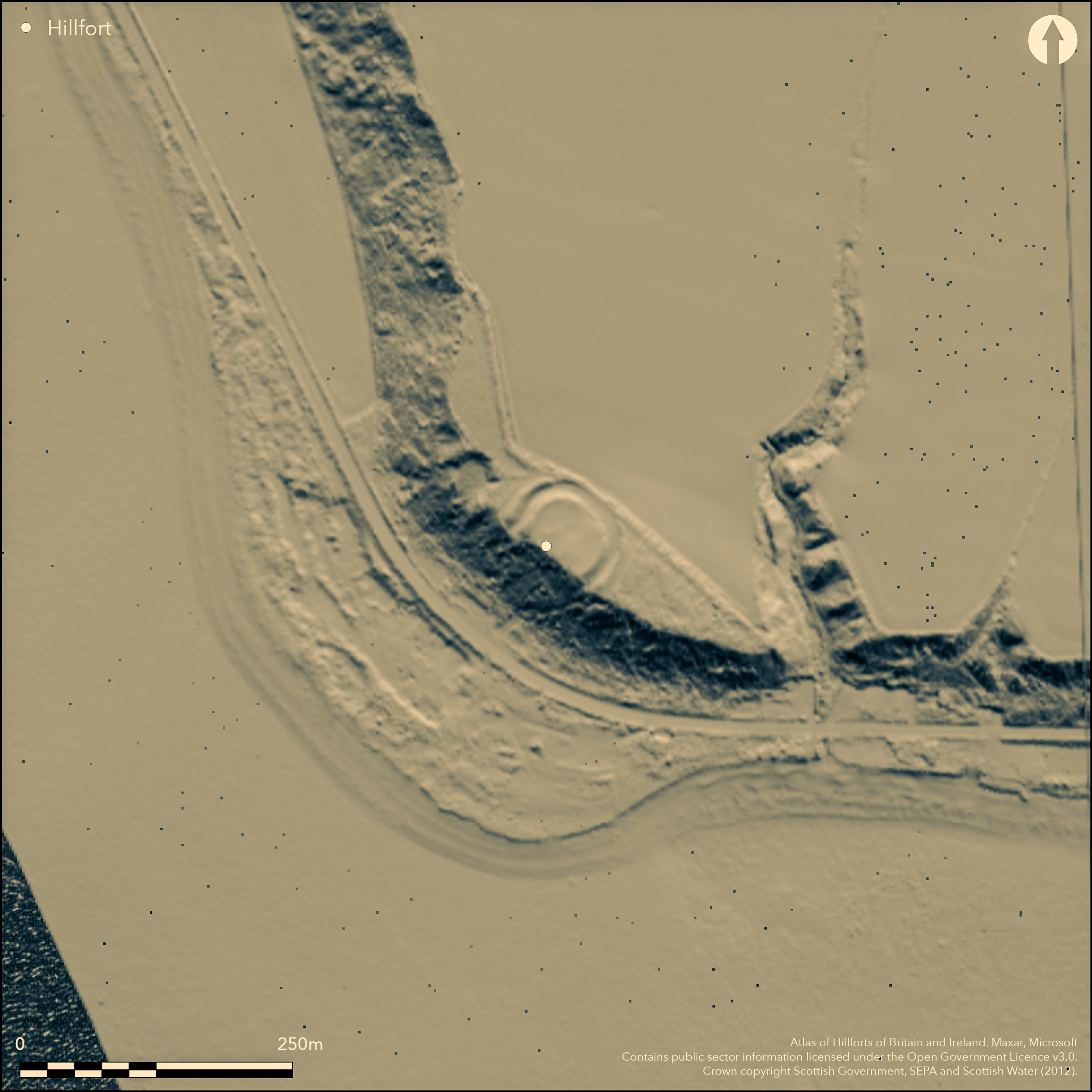
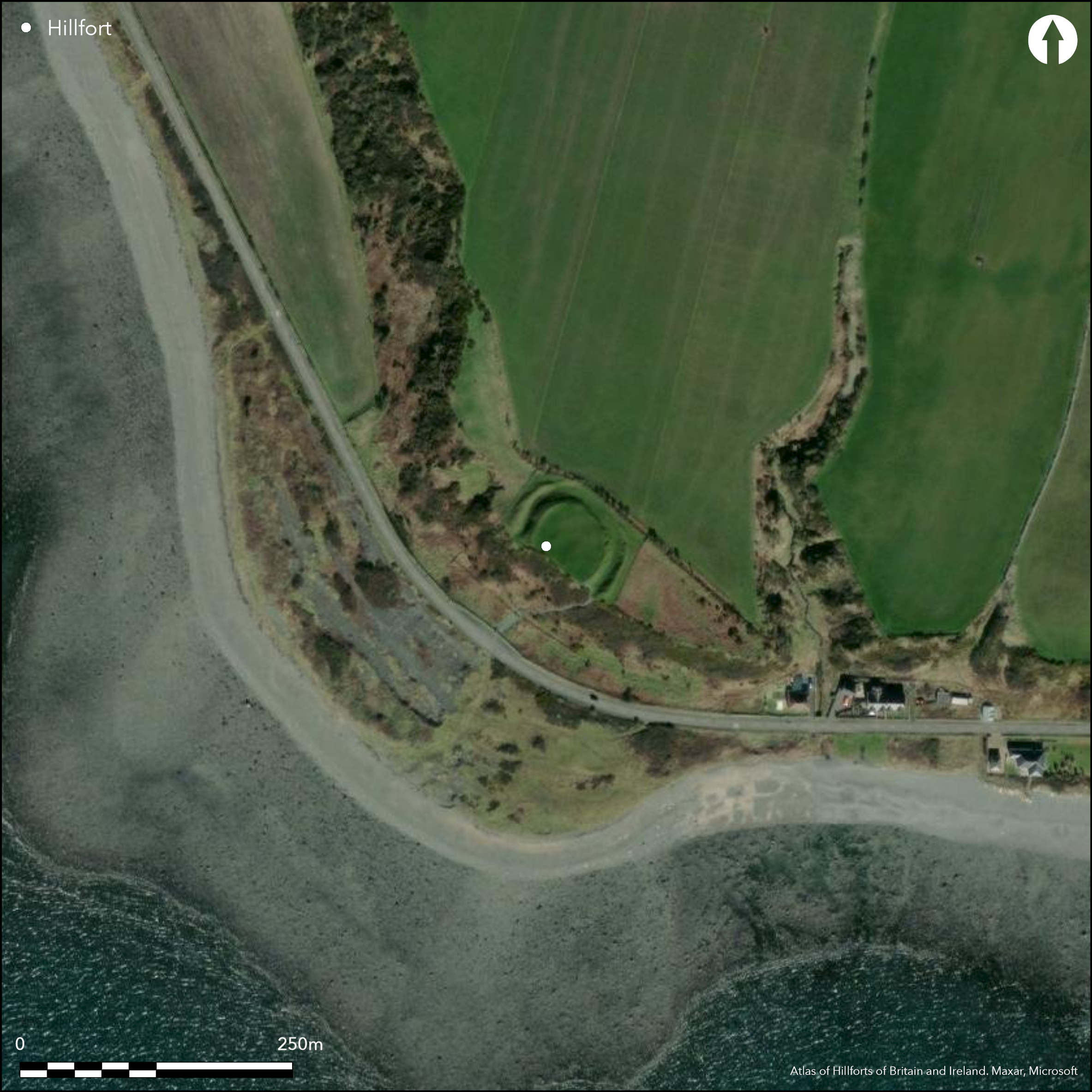
This small fortification is situated on the edge of the coastal escarpment overlooking the shore on the SW coast of the Machars. D-shaped on plan, its interior measures 38m from NW to SE along the chord by 26m transversely (0.09ha). The defences comprise an arc of twin earthen ramparts with a medial ditch resting at either end upon the edge of the escarpment. The ditch forms the major component of this barrier, measuring up to 10m in breadth by 3.5m in depth, and though the inner rampart barely rises above the level of the interior for much of its course, partly on account of later cultivation, the outer still stands about 1.1m high externally on the NW. Elsewhere it too has been heavily reduced, particularly around the lower side of the perimeter on the NE, where it is also overlain by a later field-bank. It has been assumed that the entrance also lies in this sector, though there is little sign of a causeway crossing the ditch here. Despite the cultivation of the interior there are possible traces of the scarp at the rear of a shallow house-platform on the NW.
Citizen Science: ✗
Reliability of Data: Confirmed
Reliability of Interpretation: Confirmed
X: -508607 Y: 7311303 (EPSG: 3857)
Longitude: -4.568892562080701 Latitude: 54.73862614577272 (EPSG:4326)
Country: Scotland
Current County or Unitary Authority: Dumfries & Galloway
Historic County: Wigtownshire
Current Parish/Community/Council/Townland: Mochrum
None
| Extant | ✓ |
| Cropmark | ✗ |
| Likely Destroyed | ✗ |
None
| Woodland | ✗ |
| Commercial Forestry Plantation | ✗ |
| Parkland | ✗ |
| Pasture (Grazing) | ✓ |
| Arable | ✗ |
| Scrub/Bracken | ✗ |
| Bare Outcrop | ✗ |
| Heather/Moorland | ✗ |
| Heath | ✗ |
| Built-up | ✗ |
| Coastal Grassland | ✗ |
| Other | ✗ |
The ground occupied by the enclosure slopes gently away to the NE from the lip of the escarpment.
| Contour Fort | ✗ |
| Partial Contour Fort | ✗ |
| Promontory Fort | ✗ |
| Hillslope Fort | ✓ |
| Level Terrain Fort | ✗ |
| Marsh Fort | ✗ |
| Multiple Enclosure Fort | ✗ |
| Hilltop | ✗ |
| Coastal Promontory | ✗ |
| Inland Promontory | ✗ |
| Valley Bottom | ✗ |
| Knoll/Hillock/Outcrop | ✗ |
| Ridge | ✗ |
| Cliff/Plateau-edge/Scarp | ✓ |
| Hillslope | ✓ |
| Lowland | ✗ |
| Spur | ✗ |
Dominant Topographic Feature: None
| North | ✗ |
| Northeast | ✓ |
| East | ✗ |
| Southeast | ✗ |
| South | ✗ |
| Southwest | ✗ |
| West | ✗ |
| Northwest | ✗ |
| Level | ✗ |
Altitude: 30.0m
N/A
In the absence of excavation, there are neither stratified artefacts nor radiocarbon dates to provide a chronology for the defences.
Reliability: D - None
| Pre 1200BC | ✗ |
| 1200BC - 800BC | ✗ |
| 800BC - 400BC | ✗ |
| 400BC - AD50 | ✗ |
| AD50 - AD400 | ✗ |
| AD400 - AD 800 | ✗ |
| Post AD800 | ✗ |
| Unknown | ✓ |
| Pre Hillfort: | None |
| Post Hillfort: | None |
Implicit in the depiction on Roy's Map of 1747-55, it is shown as a Danish Fort by John Aislie on his county map of Wigtonshire in 1782, and appears in more detail on the 1st edition of the OS 6-inch map (Wigtownshire 1850, sheet 33). In 1911 RCAHMS prepared a description for the County Inventory of Wigtownshire (RCAHMS 1912, 78, no.199). Taken into Guardianship by the Office of Works in 1921. RCAHMS prepared a plan in 1955, and the OS re-surveyed at 1:2500 in 1977.
| 1st Identified Map Depiction (1755): | implicit in the depiction but not annotated |
| Other (1849): | Annotated Fort on the 1st edition OS 6-inch map (Wigtownshire 1850, sheet 33) |
| Other (1911): | Description (RCAHMS 1912, 78, no.199) |
| Other (1921): | Scheduled |
| Earthwork Survey (1955): | 1:300 plan (RCAHMS WGD 4/1-2) |
| Other (1977): | Resurveyed at 1:2500 by the OS |
| Other (2002): | Re-Scheduled |
| Other (2014): | Visit by the Hillfort Study Group |
Ploughed over in the past, but possible site of one round-house can be identified on the NW side of the interior.
None
| None | ✓ |
| Spring | ✗ |
| Stream | ✗ |
| Pool | ✗ |
| Flush | ✗ |
| Well | ✗ |
| Other | ✗ |
Shallow scarp describing an arc on the NW side of the interior.
| No Known Features | ✗ |
| Round Stone Structures | ✗ |
| Rectangular Stone Structures | ✗ |
| Curvilinear Platforms | ✓ |
| Other Roundhouse Evidence | ✗ |
| Pits | ✗ |
| Quarry Hollows | ✗ |
| Other | ✗ |
None
| No Known Excavation | ✓ |
| Pits | ✗ |
| Postholes | ✗ |
| Roundhouses | ✗ |
| Rectangular Structures | ✗ |
| Roads/Tracks | ✗ |
| Quarry Hollows | ✗ |
| Other | ✗ |
| Nothing Found | ✗ |
None
| No Known Geophysics | ✓ |
| Pits | ✗ |
| Roundhouses | ✗ |
| Rectangular Structures | ✗ |
| Roads/Tracks | ✗ |
| Quarry Hollows | ✗ |
| Other | ✗ |
| Nothing Found | ✗ |
None
| No Known Finds | ✓ |
| Pottery | ✗ |
| Metal | ✗ |
| Metalworking | ✗ |
| Human Bones | ✗ |
| Animal Bones | ✗ |
| Lithics | ✗ |
| Environmental | ✗ |
| Other | ✗ |
None
| APs Not Checked | ✗ |
| None | ✓ |
| Roundhouses | ✗ |
| Rectangular Structures | ✗ |
| Pits | ✗ |
| Postholes | ✗ |
| Roads/Tracks | ✗ |
| Other | ✗ |
See main summary
| 1: | Ploughed down gap on the NE |
| 2: | It is assumed there is an entrance on the NE, downslope, side |
Guard Chambers: ✗
Chevaux de Frise: ✗
Two ramparts with a medial ditch backing onto the edge of the coastal escarpment.
| Area 1: | 0.09ha. |
| Total: | 0.09ha. |
Total Footprint Area: 0.24ha.
None
| ✗ | None |
| ✗ | None |
| NE Quadrant: | 2 |
| SE Quadrant: | 2 |
| SW Quadrant: | 0 |
| NW Quadrant: | 2 |
| Total: | 2 |
| Partial Univallate | ✗ |
| Univallate | ✗ |
| Partial Bivallate | ✓ |
| Bivallate | ✗ |
| Partial Multivallate | ✗ |
| Multivallate | ✗ |
| Unknown | ✗ |
| Partial Univallate | ✗ |
| Univallate | ✗ |
| Partial Bivallate | ✗ |
| Bivallate | ✗ |
| Partial Multivallate | ✗ |
| Multivallate | ✗ |
None
| None | ✗ |
| Earthen Bank | ✓ |
| Stone Wall | ✗ |
| Rubble | ✗ |
| Wall-walk | ✗ |
| Evidence of Timber | ✗ |
| Vitrification | ✗ |
| Other Burning | ✗ |
| Palisade | ✗ |
| Counter Scarp Bank | ✗ |
| Berm | ✗ |
| Unfinished | ✗ |
| Other | ✗ |
None
| None | ✗ |
| Earthen Bank | ✗ |
| Stone Wall | ✗ |
| Murus Duplex | ✗ |
| Timber-framed | ✗ |
| Timber-laced | ✗ |
| Vitrification | ✗ |
| Other Burning | ✗ |
| Palisade | ✗ |
| Counter Scarp Bank | ✗ |
| Berm | ✗ |
| Unfinished | ✗ |
| No Known Excavation | ✓ |
| Other | ✗ |
| ✗ | None |
| ✓ | None |
Number of Ditches: 1
| ✗ | None |
Feachem, R (1963b) A guide to prehistoric Scotland, London (p 159-60).
RCAHMS (1912) The Royal Commission on the Ancient and Historical Monuments and Constructions of Scotland. Fourth report and inventory of monuments and constructions in Galloway, 1, county of Wigtown, Edinburgh
Atlas of Hillforts:
Wikidata:
This work is licensed under CC BY-SA 4.0![]()
![]()
![]() and should be cited as:
and should be cited as:
Lock, Gary and Ralston, Ian. 2024. Atlas of Hillforts of Britain and Ireland. Available at: https://hillforts.arch.ox.ac.uk
Document Version 1.1