Satellite Imagery
Satellite Imagery
HER: Dumfries & Galloway MDG2736 (None)
NMR: NX 43 NE 8 (63098)
SM: 1985
NGR: NX 4803 3605
X: 248030 Y: 536050 (OSGB36)
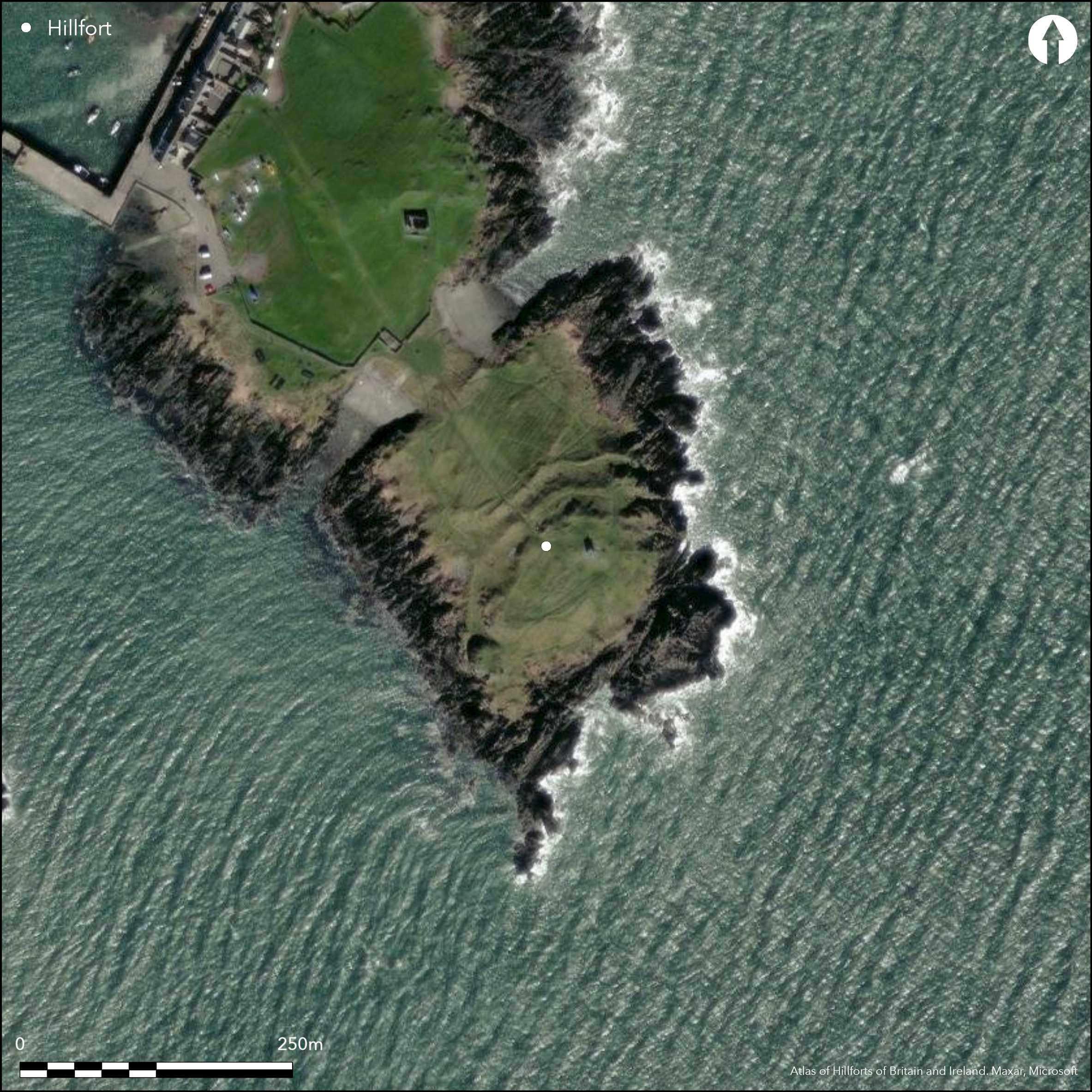
The southernmost tip of the Isle of Whithorn, which was still a tidal island at the beginning of the 19th century, is enclosed by an extensive set of fortifications, the outermost of which is a single wall, now reduced to a stony bank, cutting across on the seaward side of a narrow isthmus that divides the isle into two roughly equal portions. Resting on the outcrops that form this side of the isthmus, which on the SW rise into a cliff over 5m high, this is a natural position to place a rampart, which for a maximum of length of 95m cuts off an area of 1.6ha above the sea-washed rocks of the shoreline, and considerably more if these are included. The ground immediately behind this rampart forms an undulating terrace which has been cultivated in rigs, the plot measuring about 80m by 50m (0.3ha) and bounded by low lynchets on both the NE and the SW. The SE margin of this plot is marked by a 30m wide belt of three more ramparts, which isolate the flat-topped hillock that forms the seaward end of the promontory. The two outer ramparts and their external ditches cut across the promontory from shore to shore, apparently exploiting various ribs of outcrop and intervening gullies in an irregular but roughly concentric line; the central sector of the inner of these ditches is choked with loose stones. To the rear of them yet another ditch can be seen, which has been cut back into the flank of the hillock and seems to swing round its SW end inside the rocky boss known as the Watch Craig. Its central sector is also choked with loose stones, but in this case it seems to have partly collapsed from a rampart extending round the summit of the hillock. This rampart is seldom more than a stony scarp, but is a consistent feature all the way round the margin and encloses an area measuring about 80m from NE to SW by 30m transversely (0.23ha). A complete circuit of defences in a fort in this sort of position is unusual, but here there are also traces of rubble possibly belonging to the second rampart amongst the rocks at the foot of the slope on the southern, seaward, quarter. The position of the entrance is uncertain, one modern path approaching across the defences from the NW. A gap in the innermost rampart on the NE is more probably original, but it is not clear how an entrance way would have reached it through the outer defences.
Citizen Science: ✗
Reliability of Data: Confirmed
Reliability of Interpretation: Confirmed
X: -485314 Y: 7303184 (EPSG: 3857)
Longitude: -4.359651911283482 Latitude: 54.69649562494233 (EPSG:4326)
Country: Scotland
Current County or Unitary Authority: Dumfries & Galloway
Historic County: Wigtownshire
Current Parish/Community/Council/Townland: Whithorn
None
| Extant | ✓ |
| Cropmark | ✗ |
| Likely Destroyed | ✗ |
None
| Woodland | ✗ |
| Commercial Forestry Plantation | ✗ |
| Parkland | ✗ |
| Pasture (Grazing) | ✗ |
| Arable | ✗ |
| Scrub/Bracken | ✗ |
| Bare Outcrop | ✗ |
| Heather/Moorland | ✗ |
| Heath | ✗ |
| Built-up | ✗ |
| Coastal Grassland | ✓ |
| Other | ✗ |
None
| Contour Fort | ✗ |
| Partial Contour Fort | ✗ |
| Promontory Fort | ✓ |
| Hillslope Fort | ✗ |
| Level Terrain Fort | ✗ |
| Marsh Fort | ✗ |
| Multiple Enclosure Fort | ✓ |
| Hilltop | ✗ |
| Coastal Promontory | ✓ |
| Inland Promontory | ✗ |
| Valley Bottom | ✗ |
| Knoll/Hillock/Outcrop | ✗ |
| Ridge | ✗ |
| Cliff/Plateau-edge/Scarp | ✗ |
| Hillslope | ✗ |
| Lowland | ✗ |
| Spur | ✗ |
Dominant Topographic Feature: None
| North | ✗ |
| Northeast | ✗ |
| East | ✗ |
| Southeast | ✗ |
| South | ✗ |
| Southwest | ✗ |
| West | ✗ |
| Northwest | ✗ |
| Level | ✓ |
Altitude: 15.0m
N/A
In the absence of excavation, there are neither stratified artefacts nor radiocarbon dates to provide a chronology for the defences.
Reliability: D - None
| Pre 1200BC | ✗ |
| 1200BC - 800BC | ✗ |
| 800BC - 400BC | ✗ |
| 400BC - AD50 | ✗ |
| AD50 - AD400 | ✗ |
| AD400 - AD 800 | ✗ |
| Post AD800 | ✗ |
| Unknown | ✓ |
| Pre Hillfort: | None |
| Post Hillfort: | Post-medieval cultivation visible between the rampart at the isthmus and the main belt of defences. |
First noted in 1849 on the 1st edition of the OS 6-inch map (Wigtownshire 1850, sheet 34), the depiction was refined on the 25-inch map in 1895 (Wigtownshire 1895, sheet 36.9). The rampart on the seaward side of the isthmus however, was first noted in 1911 in the description in the County Inventory for Wigtownshire (RCAHMS 1912, 177, no.504). OGS Crawford visited the site for the OS, and it was also re-surveyed at 1:2500 in 1973. More recently in 1997 it has been surveyed as part of a coastal evaluation (Toolis 2003, 50-1, fig 8), and in 2008-9 saw further topographical survey and geophysical work (McCarthy 2008, 55). It was Scheduled in 1939.
| 1st Identified Map Depiction (1849): | Annotated Fort on the 1st edition OS 6-inch map (Wigtownshire 1850, sheet 34) |
| Other (1895): | 25-inch map (Wigtownshire 1895, sheet 36.9) |
| Other (1911): | Description (RCAHMS 1912, 177, no.504) |
| Other (1939): | Scheduled |
| Other (1973): | Resurveyed at 1:2500 by the OS |
| Earthwork Survey (1997): | Toolis 2003, 50-1, fig 8 |
| Geophysical Survey (2009): | and earthwork survey (McCarthy 2008, 55; Armit et al 2009) |
| Other (2014): | Visited by Hillfort Study Group |
Featureless apart from traces of rigged cultivation
None
| None | ✓ |
| Spring | ✗ |
| Stream | ✗ |
| Pool | ✗ |
| Flush | ✗ |
| Well | ✗ |
| Other | ✗ |
None
| No Known Features | ✓ |
| Round Stone Structures | ✗ |
| Rectangular Stone Structures | ✗ |
| Curvilinear Platforms | ✗ |
| Other Roundhouse Evidence | ✗ |
| Pits | ✗ |
| Quarry Hollows | ✗ |
| Other | ✗ |
None
| No Known Excavation | ✓ |
| Pits | ✗ |
| Postholes | ✗ |
| Roundhouses | ✗ |
| Rectangular Structures | ✗ |
| Roads/Tracks | ✗ |
| Quarry Hollows | ✗ |
| Other | ✗ |
| Nothing Found | ✗ |
Unknown
| No Known Geophysics | ✗ |
| Pits | ✗ |
| Roundhouses | ✗ |
| Rectangular Structures | ✗ |
| Roads/Tracks | ✗ |
| Quarry Hollows | ✗ |
| Other | ✓ |
| Nothing Found | ✗ |
None
| No Known Finds | ✓ |
| Pottery | ✗ |
| Metal | ✗ |
| Metalworking | ✗ |
| Human Bones | ✗ |
| Animal Bones | ✗ |
| Lithics | ✗ |
| Environmental | ✗ |
| Other | ✗ |
None
| APs Not Checked | ✗ |
| None | ✓ |
| Roundhouses | ✗ |
| Rectangular Structures | ✗ |
| Pits | ✗ |
| Postholes | ✗ |
| Roads/Tracks | ✗ |
| Other | ✗ |
See main summary
| 3: | Footpath erosion follows three routes to the summit, but it is unclear whether any follow an original route. |
| 2: | The most likely original route to the interior approaches the summit from the NE |
Guard Chambers: ✗
Chevaux de Frise: ✗
| 1. Other Forms (North east): | Inner gap, but unclear how this would have crossed the outer defences. |
At least three ramparts and ditches, with a fourth spanning the isthmus to the NW.
| Area 1: | 0.2ha. |
| Area 2: | 1.6ha. |
| Total: | 1.6ha. |
Total Footprint Area: 1.6ha.
None
| ✗ | The outer rampart may represent an independent enclosure of 1.6ha. |
| ✓ | None |
| NE Quadrant: | 1 |
| SE Quadrant: | 1 |
| SW Quadrant: | 2 |
| NW Quadrant: | 3 |
| Total: | 3 |
| Partial Univallate | ✓ |
| Univallate | ✗ |
| Partial Bivallate | ✓ |
| Bivallate | ✗ |
| Partial Multivallate | ✓ |
| Multivallate | ✗ |
| Unknown | ✗ |
| Partial Univallate | ✓ |
| Univallate | ✗ |
| Partial Bivallate | ✗ |
| Bivallate | ✗ |
| Partial Multivallate | ✗ |
| Multivallate | ✗ |
None
| None | ✗ |
| Earthen Bank | ✗ |
| Stone Wall | ✗ |
| Rubble | ✓ |
| Wall-walk | ✗ |
| Evidence of Timber | ✗ |
| Vitrification | ✗ |
| Other Burning | ✗ |
| Palisade | ✗ |
| Counter Scarp Bank | ✗ |
| Berm | ✗ |
| Unfinished | ✗ |
| Other | ✗ |
None
| None | ✗ |
| Earthen Bank | ✗ |
| Stone Wall | ✗ |
| Murus Duplex | ✗ |
| Timber-framed | ✗ |
| Timber-laced | ✗ |
| Vitrification | ✗ |
| Other Burning | ✗ |
| Palisade | ✗ |
| Counter Scarp Bank | ✗ |
| Berm | ✗ |
| Unfinished | ✗ |
| No Known Excavation | ✓ |
| Other | ✗ |
| ✗ | None |
| ✓ | None |
Number of Ditches: 3
| ✓ | The outlying rampart exploiting the outcrops on the seaward side of the isthmus can be seen as a subsidiary annex to the inner fort, forming an outer ward of about 0.6ha below a citadel, but alternatively it can be viewed as a freestanding promontory fort in its own right, enclosing an overall area of some 1.6ha. |
Armit, I, Friel, B, Gaffney, C and McCarthy, M 2009 A survey of Isle Head Fort, Isle of Whithorn, January 2009: Second Interim Report. University of Bradford (Available at RCAHMS MS6900)
McCarthy, M (2008) 'Isle Head Fort, Whithorn, Dumfries and Galloway (Whithorn parish), survey', Discovery Excav Scot, New ser, 9, 55
RCAHMS (1912) The Royal Commission on the Ancient and Historical Monuments and Constructions of Scotland. Fourth report and inventory of monuments and constructions in Galloway, 1, county of Wigtown, Edinburgh
Toolis, R (2003) 'A study of the promontory forts of the north Solway coast'. Trans Dumfriesshire Galloway natur Hist Antiq Soc 3 Ser, 77, 37-78.
Atlas of Hillforts:
Wikidata:
This work is licensed under CC BY-SA 4.0![]()
![]()
![]() and should be cited as:
and should be cited as:
Lock, Gary and Ralston, Ian. 2024. Atlas of Hillforts of Britain and Ireland. Available at: https://hillforts.arch.ox.ac.uk
Document Version 1.1