Satellite Imagery
Satellite Imagery
HER: Dumfries & Galloway MDG2775 (None)
NMR: NX 43 SW 1 (63137)
SM: None
NGR: NX 4482 3423
X: 244820 Y: 534230 (OSGB36)
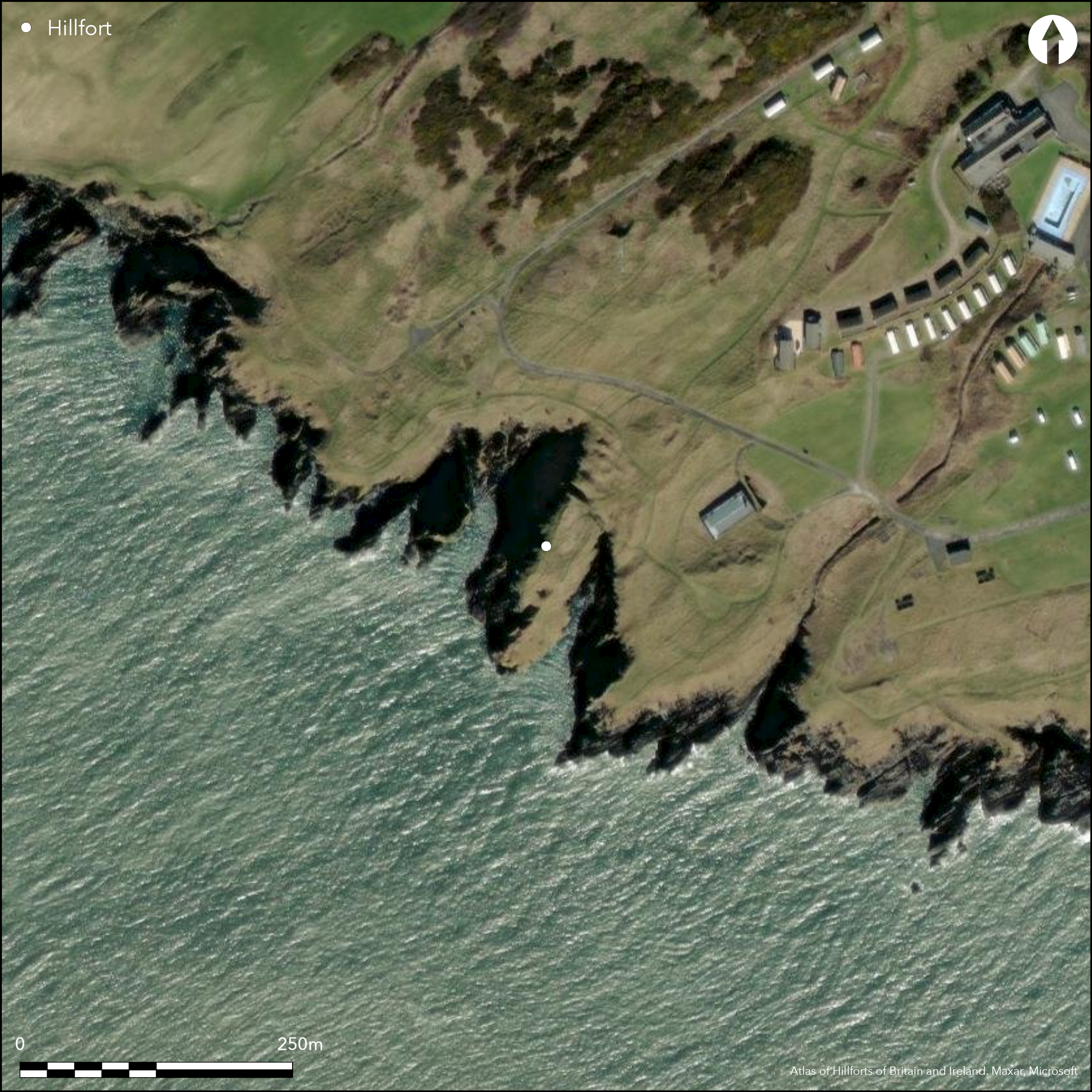
This promontory work has been re-occuppied for the site of a castle, with a stone wall rising vertically from the bottom of the innermost rock cut ditch, which itself measures at least 7.8m in breadth by over 3m in depth and cuts across the neck of the promontory to either side of a central causeway, from the head of a precipitous cleft on the SE to the cliff-edge on the NW. Whether this ditch has been adapted from the innermost defences of the earlier promontory fort is unclear, but along the NW margin of the promontory the stubs of at least four outer ramparts can be seen, each with an external ditch. With the exception of the innermost, which appears to be a counterscarp bank to the castle ditch, all these ramparts are heavily disturbed, to the point in the central sector immediately outside the entrance into the castle that they have been levelled. Where they re-emerge eastwards, swinging round the head of the cleft protecting the SE side of the promontory, only two ramparts and ditches can be seen, both giving the appearance that they are more substantial than any of those visible on the NW. The interior of the castle measures 88m in length from NE to SW by 25m transversely (0.16ha), the area immediately behind the wall being occupied by the footings of three buildings, but if any of the outer lines formed the inner rampart of the promontory fort its interior would have exceeded 0.2ha.
Citizen Science: ✗
Reliability of Data: Confirmed
Reliability of Interpretation: Confirmed
X: -490746 Y: 7299848 (EPSG: 3857)
Longitude: -4.408445081835134 Latitude: 54.67917459698042 (EPSG:4326)
Country: Scotland
Current County or Unitary Authority: Dumfries & Galloway
Historic County: Wigtownshire
Current Parish/Community/Council/Townland: Whithorn
None
| Extant | ✓ |
| Cropmark | ✗ |
| Likely Destroyed | ✗ |
None
| Woodland | ✗ |
| Commercial Forestry Plantation | ✗ |
| Parkland | ✗ |
| Pasture (Grazing) | ✗ |
| Arable | ✗ |
| Scrub/Bracken | ✗ |
| Bare Outcrop | ✗ |
| Heather/Moorland | ✗ |
| Heath | ✗ |
| Built-up | ✗ |
| Coastal Grassland | ✓ |
| Other | ✗ |
None
| Contour Fort | ✗ |
| Partial Contour Fort | ✗ |
| Promontory Fort | ✓ |
| Hillslope Fort | ✗ |
| Level Terrain Fort | ✗ |
| Marsh Fort | ✗ |
| Multiple Enclosure Fort | ✗ |
| Hilltop | ✗ |
| Coastal Promontory | ✓ |
| Inland Promontory | ✗ |
| Valley Bottom | ✗ |
| Knoll/Hillock/Outcrop | ✗ |
| Ridge | ✗ |
| Cliff/Plateau-edge/Scarp | ✗ |
| Hillslope | ✗ |
| Lowland | ✗ |
| Spur | ✗ |
Dominant Topographic Feature: None
| North | ✗ |
| Northeast | ✗ |
| East | ✗ |
| Southeast | ✗ |
| South | ✗ |
| Southwest | ✗ |
| West | ✗ |
| Northwest | ✗ |
| Level | ✓ |
Altitude: 25.0m
N/A
In the absence of excavation, there are neither stratified artefacts nor radiocarbon dates to provide a chronology for the earthwork defences
Reliability: D - None
| Pre 1200BC | ✗ |
| 1200BC - 800BC | ✗ |
| 800BC - 400BC | ✗ |
| 400BC - AD50 | ✗ |
| AD50 - AD400 | ✗ |
| AD400 - AD 800 | ✗ |
| Post AD800 | ✗ |
| Unknown | ✓ |
| Pre Hillfort: | None |
| Post Hillfort: | Reconstructed as a castle |
| Morphology/Earthwork/Typology: | None |
Named on Roy's map 1747-55, the castle was annotated 'in ruins' on Ainslie's map of Wigtownshire in 1782, and depicted for the first time in 1849 on the 1st edition OS 6-inch map (Wigtownshire 1850, sheet 37). Described by RCAHMS in 1911 for the County Inventory of Wigtownshire (RCAHMS 1912172-4, no.496) it was planned by RCAHMS in 1955. The OS re-surveyed at 1:2500 in 1973 and in 1996 a survey was also prepared as part of a coastal erosion evaluation (Toolis 2003, 47-8, fig 6).
| 1st Identified Map Depiction (1755): | Roy's Map 1747-55 |
| Other (1849): | Named in Gothic type on the OS 1st edition 6-inch map (Wigtownshire 1850, sheet 37) |
| Other (1895): | Annotated Fort on the OS 25-inch map (Wigtownshire 1895, sheet 35.16) |
| Other (1911): | Description (RCAHMS 1912, 172-4, no.496) |
| Earthwork Survey (1955): | Plan and description during RCAHMS Survey of Marginal Lands (RCAHMS WGD 7/1-2) |
| Other (1973): | Resurveyed at 1:2500 by the OS |
| Earthwork Survey (1996): | Toolis 2003, 47-8, fig 6 |
Occupied by later castle
None
| None | ✓ |
| Spring | ✗ |
| Stream | ✗ |
| Pool | ✗ |
| Flush | ✗ |
| Well | ✗ |
| Other | ✗ |
None
| No Known Features | ✗ |
| Round Stone Structures | ✗ |
| Rectangular Stone Structures | ✓ |
| Curvilinear Platforms | ✗ |
| Other Roundhouse Evidence | ✗ |
| Pits | ✗ |
| Quarry Hollows | ✗ |
| Other | ✗ |
None
| No Known Excavation | ✓ |
| Pits | ✗ |
| Postholes | ✗ |
| Roundhouses | ✗ |
| Rectangular Structures | ✗ |
| Roads/Tracks | ✗ |
| Quarry Hollows | ✗ |
| Other | ✗ |
| Nothing Found | ✗ |
None
| No Known Geophysics | ✓ |
| Pits | ✗ |
| Roundhouses | ✗ |
| Rectangular Structures | ✗ |
| Roads/Tracks | ✗ |
| Quarry Hollows | ✗ |
| Other | ✗ |
| Nothing Found | ✗ |
None
| No Known Finds | ✓ |
| Pottery | ✗ |
| Metal | ✗ |
| Metalworking | ✗ |
| Human Bones | ✗ |
| Animal Bones | ✗ |
| Lithics | ✗ |
| Environmental | ✗ |
| Other | ✗ |
None
| APs Not Checked | ✗ |
| None | ✗ |
| Roundhouses | ✗ |
| Rectangular Structures | ✓ |
| Pits | ✗ |
| Postholes | ✗ |
| Roads/Tracks | ✗ |
| Other | ✗ |
None known
| 1: | Large central area where the defences have been flattened outside the entrance causeway to the castle. |
| 2: | None known |
Guard Chambers: ✗
Chevaux de Frise: ✗
A belt of five ramparts with external ditches, though the innermost is probably associated with the medieval castle that occupies the interior.
| Area 1: | 0.16ha. |
| Total: | 0.16ha. |
Total Footprint Area: 0.4ha.
None
| ✗ | None |
| ✗ | None |
| NE Quadrant: | 5 |
| SE Quadrant: | 0 |
| SW Quadrant: | 0 |
| NW Quadrant: | 0 |
| Total: | 5 |
| Partial Univallate | ✗ |
| Univallate | ✗ |
| Partial Bivallate | ✗ |
| Bivallate | ✗ |
| Partial Multivallate | ✓ |
| Multivallate | ✗ |
| Unknown | ✗ |
| Partial Univallate | ✗ |
| Univallate | ✗ |
| Partial Bivallate | ✗ |
| Bivallate | ✗ |
| Partial Multivallate | ✗ |
| Multivallate | ✗ |
None
| None | ✗ |
| Earthen Bank | ✓ |
| Stone Wall | ✗ |
| Rubble | ✗ |
| Wall-walk | ✗ |
| Evidence of Timber | ✗ |
| Vitrification | ✗ |
| Other Burning | ✗ |
| Palisade | ✗ |
| Counter Scarp Bank | ✗ |
| Berm | ✗ |
| Unfinished | ✗ |
| Other | ✗ |
None
| None | ✗ |
| Earthen Bank | ✗ |
| Stone Wall | ✗ |
| Murus Duplex | ✗ |
| Timber-framed | ✗ |
| Timber-laced | ✗ |
| Vitrification | ✗ |
| Other Burning | ✗ |
| Palisade | ✗ |
| Counter Scarp Bank | ✗ |
| Berm | ✗ |
| Unfinished | ✗ |
| No Known Excavation | ✓ |
| Other | ✗ |
| ✗ | None |
| ✓ | None |
Number of Ditches: 5
| ✗ | None |
RCAHMS (1912) The Royal Commission on the Ancient and Historical Monuments and Constructions of Scotland. Fourth report and inventory of monuments and constructions in Galloway, 1, county of Wigtown, Edinburgh
Toolis, R (2003) 'A study of the promontory forts of the north Solway coast'. Trans Dumfriesshire Galloway natur Hist Antiq Soc 3 Ser, 77, 37-78.
Atlas of Hillforts:
Wikidata:
This work is licensed under CC BY-SA 4.0![]()
![]()
![]() and should be cited as:
and should be cited as:
Lock, Gary and Ralston, Ian. 2024. Atlas of Hillforts of Britain and Ireland. Available at: https://hillforts.arch.ox.ac.uk
Document Version 1.1