Satellite Imagery
Satellite Imagery
HER: Dumfries & Galloway MDG2824 (None)
NMR: NX 44 NE 5 (63187)
SM: None
NGR: NX 4947 4776
X: 249470 Y: 547760 (OSGB36)
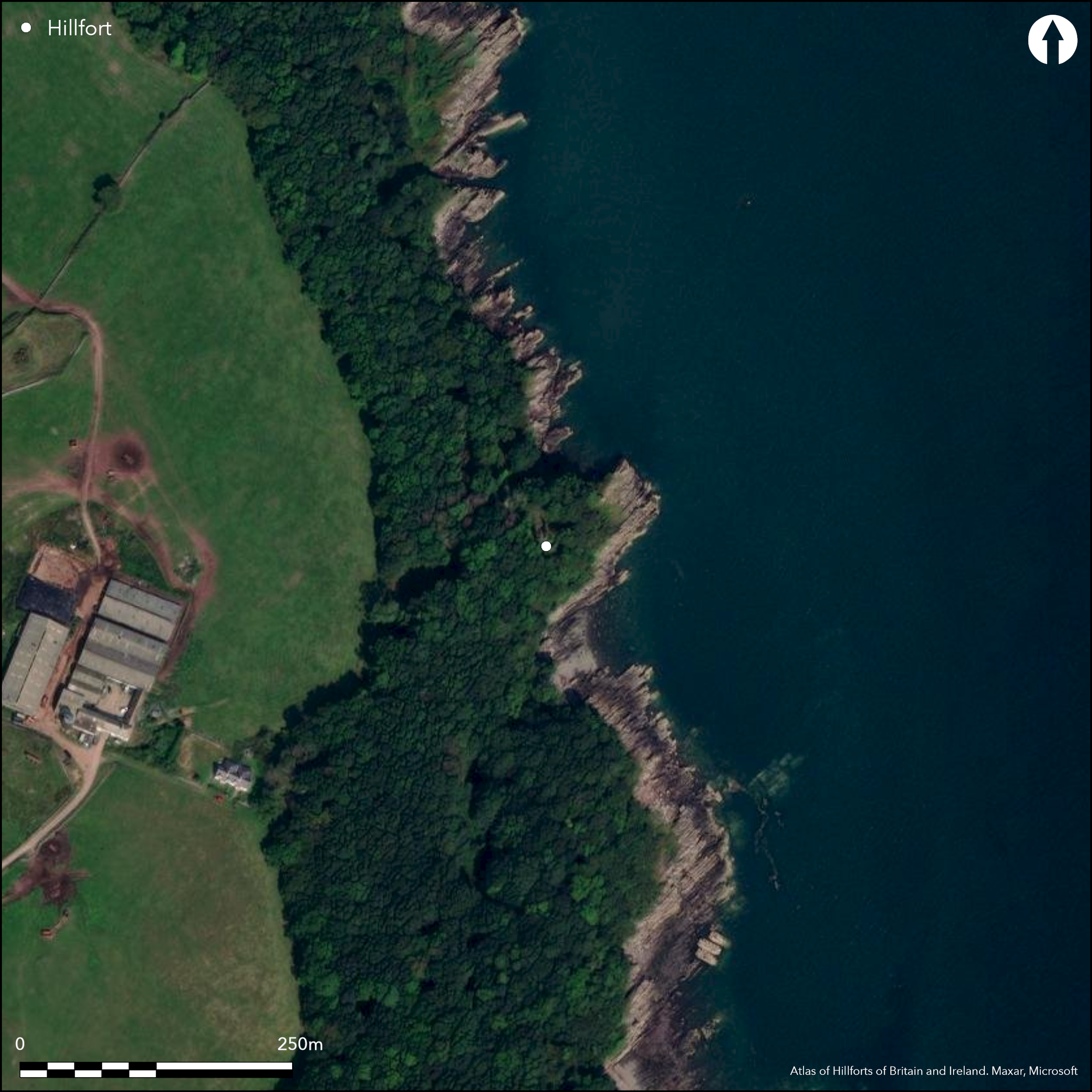
Traditionally identified as Eggerness Castle, and depicted on the 1st edition of the OS 6-inch map with an open rectangle behind an arc of ditch cutting off the approaches to this rock girt promontory from the slopes dropping in from the W, it was identified by John Palmer of the OS in 1973 as the remains of a promontory work defended by two ramparts and ditches. Of these only the outer ditch is complete, and this is shown on the earlier maps about 9m in breadth; its rampart and the inner line are heavily disturbed by the construction of more recent walls, which are themselves largely collapsed. No trace of any other structures could be seen within the interior, and the only evidence of an entrance was a possible gap in the centre of the arc of defences.
Citizen Science: ✗
Reliability of Data: Confirmed
Reliability of Interpretation: Confirmed
X: -483505 Y: 7323547 (EPSG: 3857)
Longitude: -4.343394864228172 Latitude: 54.802074969250654 (EPSG:4326)
Country: Scotland
Current County or Unitary Authority: Dumfries & Galloway
Historic County: Wigtownshire
Current Parish/Community/Council/Townland: Sorbie
None
| Extant | ✓ |
| Cropmark | ✗ |
| Likely Destroyed | ✗ |
None
| Woodland | ✓ |
| Commercial Forestry Plantation | ✗ |
| Parkland | ✗ |
| Pasture (Grazing) | ✗ |
| Arable | ✗ |
| Scrub/Bracken | ✗ |
| Bare Outcrop | ✗ |
| Heather/Moorland | ✗ |
| Heath | ✗ |
| Built-up | ✗ |
| Coastal Grassland | ✗ |
| Other | ✗ |
None
| Contour Fort | ✗ |
| Partial Contour Fort | ✗ |
| Promontory Fort | ✓ |
| Hillslope Fort | ✗ |
| Level Terrain Fort | ✗ |
| Marsh Fort | ✗ |
| Multiple Enclosure Fort | ✗ |
| Hilltop | ✗ |
| Coastal Promontory | ✓ |
| Inland Promontory | ✗ |
| Valley Bottom | ✗ |
| Knoll/Hillock/Outcrop | ✗ |
| Ridge | ✗ |
| Cliff/Plateau-edge/Scarp | ✗ |
| Hillslope | ✗ |
| Lowland | ✗ |
| Spur | ✗ |
Dominant Topographic Feature: None
| North | ✗ |
| Northeast | ✗ |
| East | ✗ |
| Southeast | ✗ |
| South | ✗ |
| Southwest | ✗ |
| West | ✗ |
| Northwest | ✗ |
| Level | ✓ |
Altitude: 5.0m
N/A
In the absence of excavation, there are neither stratified artefacts nor radiocarbon dates to provide a chronology for the defences.
Reliability: D - None
| Pre 1200BC | ✗ |
| 1200BC - 800BC | ✗ |
| 800BC - 400BC | ✗ |
| 400BC - AD50 | ✗ |
| AD50 - AD400 | ✗ |
| AD400 - AD 800 | ✗ |
| Post AD800 | ✗ |
| Unknown | ✓ |
| Pre Hillfort: | None |
| Post Hillfort: | None |
Eggerness Castle is annotated on Roy's Map 1747-55, which gives an impression of an arc of defences cutting off the promontory, but on John Ainslie's Map of the County of Wigton of 1782 it is annotated 'Ruins of Egerness'. The outer ditch is apparently depicted on the 1st edition of the OS 6-inch map (Wigtownshire 1850, sheet 30). Not noted in the County inventory for Wigtownshire (RCAHMS 1912), the site was re-surveyed by the OS at 1:2500 in 1970.
| 1st Identified Map Depiction (1755): | Roy's Map (1747-55) |
| 1st Identified Written Reference (1838): | New Statistical Account 4 (Wigtonshire), 29 |
| Other (1849): | Depiction named on 1st edition OS 6-inch map (Wigtownshire 1850, sheet 30) |
| Other (1970): | OS depiction at 1:2500 |
Old walls forming elements of the plantation.
None
| None | ✓ |
| Spring | ✗ |
| Stream | ✗ |
| Pool | ✗ |
| Flush | ✗ |
| Well | ✗ |
| Other | ✗ |
None
| No Known Features | ✓ |
| Round Stone Structures | ✗ |
| Rectangular Stone Structures | ✗ |
| Curvilinear Platforms | ✗ |
| Other Roundhouse Evidence | ✗ |
| Pits | ✗ |
| Quarry Hollows | ✗ |
| Other | ✗ |
None
| No Known Excavation | ✓ |
| Pits | ✗ |
| Postholes | ✗ |
| Roundhouses | ✗ |
| Rectangular Structures | ✗ |
| Roads/Tracks | ✗ |
| Quarry Hollows | ✗ |
| Other | ✗ |
| Nothing Found | ✗ |
None
| No Known Geophysics | ✓ |
| Pits | ✗ |
| Roundhouses | ✗ |
| Rectangular Structures | ✗ |
| Roads/Tracks | ✗ |
| Quarry Hollows | ✗ |
| Other | ✗ |
| Nothing Found | ✗ |
None
| No Known Finds | ✓ |
| Pottery | ✗ |
| Metal | ✗ |
| Metalworking | ✗ |
| Human Bones | ✗ |
| Animal Bones | ✗ |
| Lithics | ✗ |
| Environmental | ✗ |
| Other | ✗ |
Under trees
| APs Not Checked | ✗ |
| None | ✓ |
| Roundhouses | ✗ |
| Rectangular Structures | ✗ |
| Pits | ✗ |
| Postholes | ✗ |
| Roads/Tracks | ✗ |
| Other | ✗ |
See main summary
| 1: | None |
| 2: | Possible central gap. |
Guard Chambers: ✗
Chevaux de Frise: ✗
| 1. Simple Gap (West): | None |
Two ramparts and ditches cutting off the promontory
| Area 1: | 0.2ha. |
| Total: | 0.2ha. |
Total Footprint Area: 0.38ha.
None
| ✗ | Very rough measurements from maps as the defences cannot be seen beneath the tree cover. |
| ✗ | None |
| NE Quadrant: | 0 |
| SE Quadrant: | 0 |
| SW Quadrant: | 0 |
| NW Quadrant: | 2 |
| Total: | 2 |
| Partial Univallate | ✗ |
| Univallate | ✗ |
| Partial Bivallate | ✓ |
| Bivallate | ✗ |
| Partial Multivallate | ✗ |
| Multivallate | ✗ |
| Unknown | ✗ |
| Partial Univallate | ✗ |
| Univallate | ✗ |
| Partial Bivallate | ✗ |
| Bivallate | ✗ |
| Partial Multivallate | ✗ |
| Multivallate | ✗ |
None
| None | ✗ |
| Earthen Bank | ✓ |
| Stone Wall | ✗ |
| Rubble | ✗ |
| Wall-walk | ✗ |
| Evidence of Timber | ✗ |
| Vitrification | ✗ |
| Other Burning | ✗ |
| Palisade | ✗ |
| Counter Scarp Bank | ✗ |
| Berm | ✗ |
| Unfinished | ✗ |
| Other | ✗ |
None
| None | ✗ |
| Earthen Bank | ✗ |
| Stone Wall | ✗ |
| Murus Duplex | ✗ |
| Timber-framed | ✗ |
| Timber-laced | ✗ |
| Vitrification | ✗ |
| Other Burning | ✗ |
| Palisade | ✗ |
| Counter Scarp Bank | ✗ |
| Berm | ✗ |
| Unfinished | ✗ |
| No Known Excavation | ✓ |
| Other | ✗ |
| ✗ | None |
| ✓ | None |
Number of Ditches: 2
| ✗ | None |
NSA (1834-1845) The new statistical account of Scotland by the ministers of the respective parishes under the superintendence of a committee of the society for the benefit of the sons and daughters of the clergy, 15v Edinburgh
Atlas of Hillforts:
Wikidata:
This work is licensed under CC BY-SA 4.0![]()
![]()
![]() and should be cited as:
and should be cited as:
Lock, Gary and Ralston, Ian. 2024. Atlas of Hillforts of Britain and Ireland. Available at: https://hillforts.arch.ox.ac.uk
Document Version 1.1