Satellite Imagery
Satellite Imagery
HER: Dumfries & Galloway MDG2886 (None)
NMR: NX 44 SE 3 (63253)
SM: 1968
NGR: NX 4786 4026
X: 247860 Y: 540260 (OSGB36)
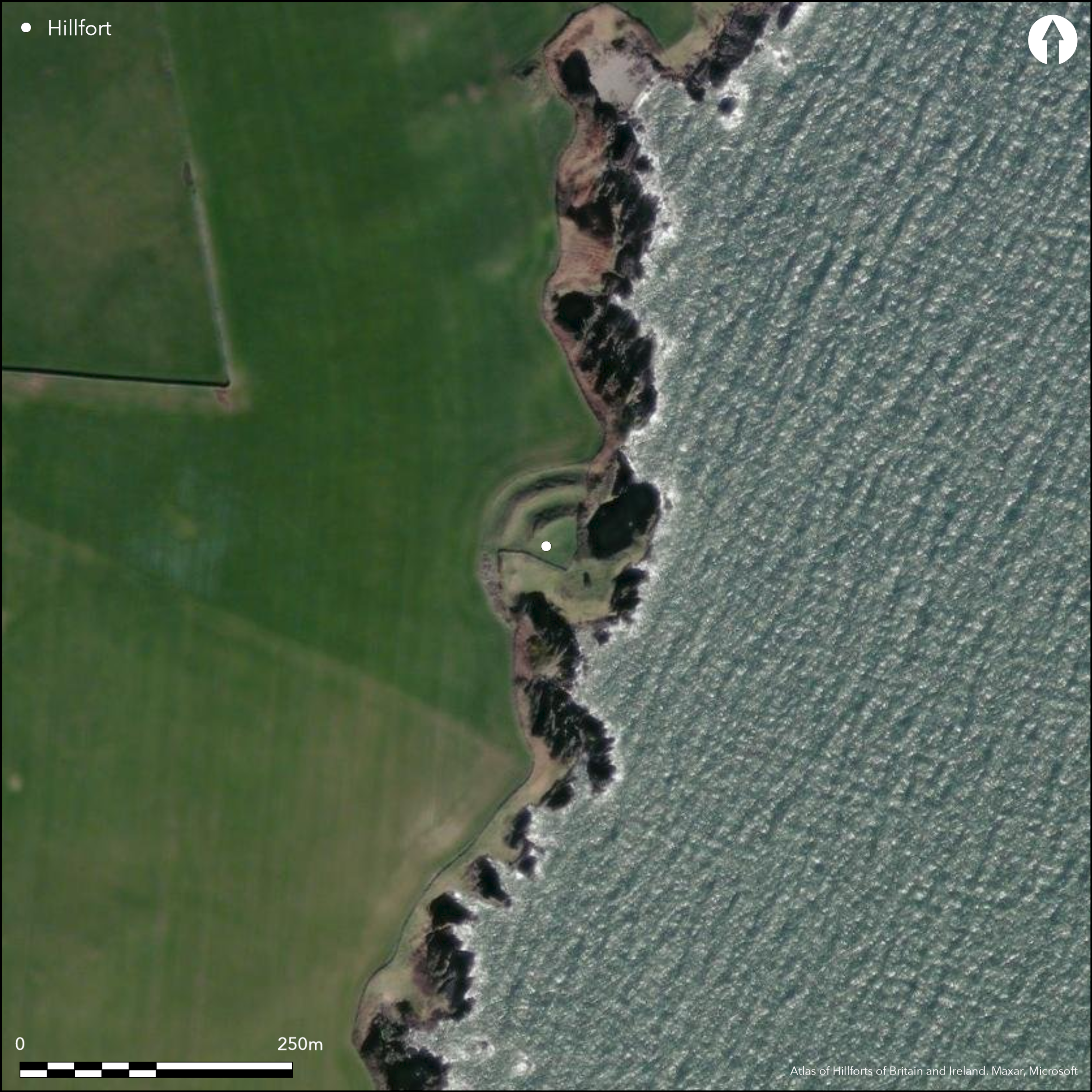
This fort occupies a heavily eroded promontory on the E coast of the Machars, Its defences comprise two massive ramparts with external ditches, which are drawn in an arc across the neck of the promontory with their ends resting on the cliff-edges well beyond the margins of the promontory itself. The inner rampart is some 9.5m in thickness and the outer 11m, standing 2.5m and 3.5m above the bottoms of their corresponding ditches, which are 9m and 6m in breadth respectively. A gap in the centre of the defences probably marks the position of the original entrance, though it has been disturbed by the use of the interior as a cattle feeding stance reported in 1996. The interior measures a maximum of 46m from NW to SE by 35m transversely (0.15ha), but has evidently been much bigger, with large areas eroded on the NE and SW, and no doubt some reduction of is SE, seaward, face too. The OS reported three possible house platforms to the rear of the rampart, but it is unlikely that any trace of these will have survived the poaching caused by cattle feeding. The only other features visible within the interior are a WW II observation post, and what may have been a contemporary breastwork and weapon pit on the S margin of the promontory.
Citizen Science: ✗
Reliability of Data: Confirmed
Reliability of Interpretation: Confirmed
X: -485852 Y: 7310459 (EPSG: 3857)
Longitude: -4.364487151690766 Latitude: 54.734246335896486 (EPSG:4326)
Country: Scotland
Current County or Unitary Authority: Dumfries & Galloway
Historic County: Wigtownshire
Current Parish/Community/Council/Townland: Whithorn
None
| Extant | ✓ |
| Cropmark | ✗ |
| Likely Destroyed | ✗ |
None
| Woodland | ✗ |
| Commercial Forestry Plantation | ✗ |
| Parkland | ✗ |
| Pasture (Grazing) | ✓ |
| Arable | ✗ |
| Scrub/Bracken | ✗ |
| Bare Outcrop | ✗ |
| Heather/Moorland | ✗ |
| Heath | ✗ |
| Built-up | ✗ |
| Coastal Grassland | ✗ |
| Other | ✗ |
None
| Contour Fort | ✗ |
| Partial Contour Fort | ✗ |
| Promontory Fort | ✓ |
| Hillslope Fort | ✗ |
| Level Terrain Fort | ✗ |
| Marsh Fort | ✗ |
| Multiple Enclosure Fort | ✗ |
| Hilltop | ✗ |
| Coastal Promontory | ✓ |
| Inland Promontory | ✗ |
| Valley Bottom | ✗ |
| Knoll/Hillock/Outcrop | ✗ |
| Ridge | ✗ |
| Cliff/Plateau-edge/Scarp | ✗ |
| Hillslope | ✗ |
| Lowland | ✗ |
| Spur | ✗ |
Dominant Topographic Feature: None
| North | ✗ |
| Northeast | ✗ |
| East | ✗ |
| Southeast | ✗ |
| South | ✗ |
| Southwest | ✗ |
| West | ✗ |
| Northwest | ✗ |
| Level | ✓ |
Altitude: 20.0m
N/A
In the absence of excavation, there are neither stratified artefacts nor radiocarbon dates to provide a chronology for the defences.
Reliability: D - None
| Pre 1200BC | ✗ |
| 1200BC - 800BC | ✗ |
| 800BC - 400BC | ✗ |
| 400BC - AD50 | ✗ |
| AD50 - AD400 | ✗ |
| AD400 - AD 800 | ✗ |
| Post AD800 | ✗ |
| Unknown | ✓ |
| Pre Hillfort: | None |
| Post Hillfort: | WW 2 observation post |
Shown on Roy's Map 1747-55 alongside its neighbour on the promontory to the N and annotated 'Dunans', it is also depicted in 1849 on the 1st edition of the OS 6-inch map (Wigtownshire 1850, sheet 34). A description was prepared by RCAHMS in 1911 (RCAHMS 1912, 176, no.501), and they returned in 1955 to draw up a plan. The OS re-surveyed at 1:2500 in 1973, and in 1996 a survey to evaluate coastal erosion was prepared (Toolis 2003, 53-4, fig 10). It was Scheduled in 1940. Photographed by RCAHMS Aerial Survey Programme in 2002
| 1st Identified Map Depiction (1755): | Roy's Map 1747-55 |
| Other (1849): | Annotated 'The Old Fort' 1st edition of the OS 6-inch map (Wigtownshire 1850, sheet 34) |
| Other (1911): | Description (RCAHMS 1912, 176, no.501) |
| Other (1940): | Scheduled |
| Earthwork Survey (1955): | 1:300 (RCAHMS WGD 9/3-4) |
| Other (1973): | Resurveyed at 1:2500 by the OS |
| Earthwork Survey (1996): | Toolis 2003, 53-4, fig 10 |
Three possible house platforms noted by OS, but it is unlikely these survive
None
| None | ✓ |
| Spring | ✗ |
| Stream | ✗ |
| Pool | ✗ |
| Flush | ✗ |
| Well | ✗ |
| Other | ✗ |
None
| No Known Features | ✗ |
| Round Stone Structures | ✗ |
| Rectangular Stone Structures | ✗ |
| Curvilinear Platforms | ✓ |
| Other Roundhouse Evidence | ✗ |
| Pits | ✗ |
| Quarry Hollows | ✗ |
| Other | ✗ |
None
| No Known Excavation | ✓ |
| Pits | ✗ |
| Postholes | ✗ |
| Roundhouses | ✗ |
| Rectangular Structures | ✗ |
| Roads/Tracks | ✗ |
| Quarry Hollows | ✗ |
| Other | ✗ |
| Nothing Found | ✗ |
None
| No Known Geophysics | ✓ |
| Pits | ✗ |
| Roundhouses | ✗ |
| Rectangular Structures | ✗ |
| Roads/Tracks | ✗ |
| Quarry Hollows | ✗ |
| Other | ✗ |
| Nothing Found | ✗ |
None
| No Known Finds | ✓ |
| Pottery | ✗ |
| Metal | ✗ |
| Metalworking | ✗ |
| Human Bones | ✗ |
| Animal Bones | ✗ |
| Lithics | ✗ |
| Environmental | ✗ |
| Other | ✗ |
None
| APs Not Checked | ✗ |
| None | ✓ |
| Roundhouses | ✗ |
| Rectangular Structures | ✗ |
| Pits | ✗ |
| Postholes | ✗ |
| Roads/Tracks | ✗ |
| Other | ✗ |
See main summary
| 1: | None |
| 2: | None |
Guard Chambers: ✗
Chevaux de Frise: ✗
| 1. Simple Gap (West): | None |
Two ramparts with external ditches cut off the approach to the promontory from the W
| Area 1: | 0.15ha. |
| Total: | 0.15ha. |
Total Footprint Area: 0.48ha.
None
| ✗ | Heavy erosion of the cliffs suggests that the interior was once considerably larger |
| ✗ | None |
| NE Quadrant: | 0 |
| SE Quadrant: | 0 |
| SW Quadrant: | 2 |
| NW Quadrant: | 2 |
| Total: | 2 |
| Partial Univallate | ✗ |
| Univallate | ✗ |
| Partial Bivallate | ✓ |
| Bivallate | ✗ |
| Partial Multivallate | ✗ |
| Multivallate | ✗ |
| Unknown | ✗ |
| Partial Univallate | ✗ |
| Univallate | ✗ |
| Partial Bivallate | ✗ |
| Bivallate | ✗ |
| Partial Multivallate | ✗ |
| Multivallate | ✗ |
None
| None | ✗ |
| Earthen Bank | ✓ |
| Stone Wall | ✗ |
| Rubble | ✗ |
| Wall-walk | ✗ |
| Evidence of Timber | ✗ |
| Vitrification | ✗ |
| Other Burning | ✗ |
| Palisade | ✗ |
| Counter Scarp Bank | ✗ |
| Berm | ✗ |
| Unfinished | ✗ |
| Other | ✗ |
None
| None | ✗ |
| Earthen Bank | ✗ |
| Stone Wall | ✗ |
| Murus Duplex | ✗ |
| Timber-framed | ✗ |
| Timber-laced | ✗ |
| Vitrification | ✗ |
| Other Burning | ✗ |
| Palisade | ✗ |
| Counter Scarp Bank | ✗ |
| Berm | ✗ |
| Unfinished | ✗ |
| No Known Excavation | ✓ |
| Other | ✗ |
| ✗ | None |
| ✓ | None |
Number of Ditches: 2
| ✗ | None |
RCAHMS (1912) The Royal Commission on the Ancient and Historical Monuments and Constructions of Scotland. Fourth report and inventory of monuments and constructions in Galloway, 1, county of Wigtown, Edinburgh
Toolis, R (2003) 'A study of the promontory forts of the north Solway coast'. Trans Dumfriesshire Galloway natur Hist Antiq Soc 3 Ser, 77, 37-78.
Atlas of Hillforts:
Wikidata:
This work is licensed under CC BY-SA 4.0![]()
![]()
![]() and should be cited as:
and should be cited as:
Lock, Gary and Ralston, Ian. 2024. Atlas of Hillforts of Britain and Ireland. Available at: https://hillforts.arch.ox.ac.uk
Document Version 1.1