Satellite Imagery
Satellite Imagery
HER: Dumfries & Galloway MDG3585 (None)
NMR: NX 64 SW 2 (63990)
SM: 1053
NGR: NX 6198 4466
X: 261980 Y: 544660 (OSGB36)
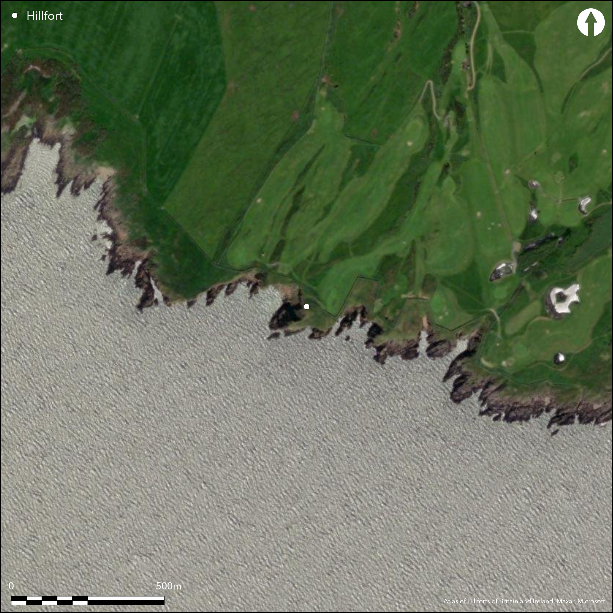
This is one of the larger and better preserved promontory works along this stretch of coast, comprising an arc of two ramparts and ditches, the outer accompanied by a counterscarp bank, cutting off the only line of approach to a precipitous coastal promontory from the NE. The interior measures 62m from NE to SW along the axis of the promontory by a maximum of 50m transversely, but the defences rest on the cliff-edge well beyond the present margins of the promontory, which is otherwise no more than 25m broad, and has evidently once been considerably larger. The innermost and middle ramparts stand up to 3.3m and 1.8m respectively above the inner and outer ditches, which are 9m and 6m in breadth. The entrance lies in the middle of the arc of defences on the NE. Nothing can now be seen of the 'narrow stone parapet' identified In 1911 the RCAHMS investigators on the crest of the innermost ramparts, but several of the five upright stones they noted at intervals along the crest of the middle rampart between the entrance and the cliff-edge on the E can still be seen. A circular depression they noted at the seaward end of the promontory, and the traces of rectangular building noted in 1951 immediately behind the rampart near the entrance, were not found when the earthworks were examined during a coastal erosion evaluation carried out in 1996 (Toolis 2003, 56-7, fig 13).
Citizen Science: ✗
Reliability of Data: Confirmed
Reliability of Interpretation: Confirmed
X: -461692 Y: 7318868 (EPSG: 3857)
Longitude: -4.147452880981884 Latitude: 54.77783659921008 (EPSG:4326)
Country: Scotland
Current County or Unitary Authority: Dumfries & Galloway
Historic County: Kirkcudbrightshire
Current Parish/Community/Council/Townland: Borgue
None
| Extant | ✓ |
| Cropmark | ✗ |
| Likely Destroyed | ✗ |
None
| Woodland | ✗ |
| Commercial Forestry Plantation | ✗ |
| Parkland | ✗ |
| Pasture (Grazing) | ✗ |
| Arable | ✗ |
| Scrub/Bracken | ✗ |
| Bare Outcrop | ✗ |
| Heather/Moorland | ✗ |
| Heath | ✗ |
| Built-up | ✗ |
| Coastal Grassland | ✓ |
| Other | ✗ |
None
| Contour Fort | ✗ |
| Partial Contour Fort | ✗ |
| Promontory Fort | ✓ |
| Hillslope Fort | ✗ |
| Level Terrain Fort | ✗ |
| Marsh Fort | ✗ |
| Multiple Enclosure Fort | ✗ |
| Hilltop | ✗ |
| Coastal Promontory | ✓ |
| Inland Promontory | ✗ |
| Valley Bottom | ✗ |
| Knoll/Hillock/Outcrop | ✗ |
| Ridge | ✗ |
| Cliff/Plateau-edge/Scarp | ✗ |
| Hillslope | ✗ |
| Lowland | ✗ |
| Spur | ✗ |
Dominant Topographic Feature: None
| North | ✗ |
| Northeast | ✗ |
| East | ✗ |
| Southeast | ✗ |
| South | ✗ |
| Southwest | ✗ |
| West | ✗ |
| Northwest | ✗ |
| Level | ✓ |
Altitude: 35.0m
N/A
In the absence of excavation, there are neither stratified artefacts nor radiocarbon dates to provide a chronology for the defences.
Reliability: D - None
| Pre 1200BC | ✗ |
| 1200BC - 800BC | ✗ |
| 800BC - 400BC | ✗ |
| 400BC - AD50 | ✗ |
| AD50 - AD400 | ✗ |
| AD400 - AD 800 | ✗ |
| Post AD800 | ✗ |
| Unknown | ✓ |
| Pre Hillfort: | None |
| Post Hillfort: | Possible traces of an overlying rectangular building observed in 1951 |
Probably shown unannotated in the hill shading of Roy's Map 1747-55, the Batteries are annotated on Ainslie's map of the Stewartry of Kirkcudbright in 1797, and they are also mentioned in the Statistical Account for the Parish of Borgue (Stat Acct 1794, 11, p 41). They are depicted in 1850 on the 1st edition of the OS 6-inch map (Kirkcudbrightshire 1854, sheet 54), and sketch-planned and described by Frederick Coles in 1892 (1893, 129-30, fig 29). Coles' plan is reproduced in the County Inventory along with a new description written in 1911 (RCAHMS 1914, 44-45, no.60). RCAHMS revisited the fort in 1951 and the OS re-surveyed the earthworks at 1:2500 in 1971. A plan was also produced by Ronan Toolis in the course of a coastal erosion evaluation in 1996 (Toolis 2003, 56-7, fig 13).
| 1st Identified Map Depiction (1755): | Implicit in the hill shading on Roy's Map (1747-55) |
| 1st Identified Written Reference (1794): | Stat Acct 1794, 11, p 41 |
| Other (1850): | Named on the 1st edition OS 6-inch map (Kirkcudbrightshire 1854, sheet 54) |
| Earthwork Survey (1892): | Sketch plan and description by Frederick Coles (1893, 129-30, fig 29) |
| Other (1911): | Description (RCAHMS 1914, 44-45, no.60) |
| Other (1937): | Scheduled |
| Other (1951): | Description RCAHMS Survey of Marginal Lands |
| Other (1971): | Resurveyed at 1:2500 by the OS |
| Earthwork Survey (1996): | Part of coastal evaluation (Toolis 2003, 56-7, fig 13) |
Featureless, though traces of a circular depression noted at seaward end in 1911 and a rectangular building behind the inner rampart near the entrance in 1951.
None
| None | ✓ |
| Spring | ✗ |
| Stream | ✗ |
| Pool | ✗ |
| Flush | ✗ |
| Well | ✗ |
| Other | ✗ |
None
| No Known Features | ✓ |
| Round Stone Structures | ✗ |
| Rectangular Stone Structures | ✗ |
| Curvilinear Platforms | ✗ |
| Other Roundhouse Evidence | ✗ |
| Pits | ✗ |
| Quarry Hollows | ✗ |
| Other | ✗ |
None
| No Known Excavation | ✓ |
| Pits | ✗ |
| Postholes | ✗ |
| Roundhouses | ✗ |
| Rectangular Structures | ✗ |
| Roads/Tracks | ✗ |
| Quarry Hollows | ✗ |
| Other | ✗ |
| Nothing Found | ✗ |
None
| No Known Geophysics | ✓ |
| Pits | ✗ |
| Roundhouses | ✗ |
| Rectangular Structures | ✗ |
| Roads/Tracks | ✗ |
| Quarry Hollows | ✗ |
| Other | ✗ |
| Nothing Found | ✗ |
None
| No Known Finds | ✓ |
| Pottery | ✗ |
| Metal | ✗ |
| Metalworking | ✗ |
| Human Bones | ✗ |
| Animal Bones | ✗ |
| Lithics | ✗ |
| Environmental | ✗ |
| Other | ✗ |
None
| APs Not Checked | ✗ |
| None | ✓ |
| Roundhouses | ✗ |
| Rectangular Structures | ✗ |
| Pits | ✗ |
| Postholes | ✗ |
| Roads/Tracks | ✗ |
| Other | ✗ |
See main summary
| 1: | None |
| 2: | None |
Guard Chambers: ✗
Chevaux de Frise: ✗
| 1. Simple Gap (North east): | None |
Three ramparts with intermediate ditches cutting off a coastal promontory.
| Area 1: | 0.1ha. |
| Total: | 0.1ha. |
Total Footprint Area: 0.4ha.
None
| ✗ | None |
| ✗ | None |
| NE Quadrant: | 2 |
| SE Quadrant: | 0 |
| SW Quadrant: | 0 |
| NW Quadrant: | 0 |
| Total: | 2 |
| Partial Univallate | ✗ |
| Univallate | ✗ |
| Partial Bivallate | ✓ |
| Bivallate | ✗ |
| Partial Multivallate | ✗ |
| Multivallate | ✗ |
| Unknown | ✗ |
| Partial Univallate | ✗ |
| Univallate | ✗ |
| Partial Bivallate | ✗ |
| Bivallate | ✗ |
| Partial Multivallate | ✗ |
| Multivallate | ✗ |
None
| None | ✗ |
| Earthen Bank | ✓ |
| Stone Wall | ✗ |
| Rubble | ✗ |
| Wall-walk | ✗ |
| Evidence of Timber | ✗ |
| Vitrification | ✗ |
| Other Burning | ✗ |
| Palisade | ✗ |
| Counter Scarp Bank | ✓ |
| Berm | ✗ |
| Unfinished | ✗ |
| Other | ✗ |
None
| None | ✗ |
| Earthen Bank | ✗ |
| Stone Wall | ✗ |
| Murus Duplex | ✗ |
| Timber-framed | ✗ |
| Timber-laced | ✗ |
| Vitrification | ✗ |
| Other Burning | ✗ |
| Palisade | ✗ |
| Counter Scarp Bank | ✗ |
| Berm | ✗ |
| Unfinished | ✗ |
| No Known Excavation | ✓ |
| Other | ✗ |
| ✗ | None |
| ✓ | None |
Number of Ditches: 2
| ✗ | None |
Coles, F R (1893) 'The motes, forts, and doons in the east and west divisions of the Stewartry of Kirkcudbright', Proc Soc Antiq Scot 27, 92-182
NSA (1834-1845) The new statistical account of Scotland by the ministers of the respective parishes under the superintendence of a committee of the society for the benefit of the sons and daughters of the clergy.
RCAHMS (1914) The Royal Commission on the Ancient and Historical Monuments and Constructions of Scotland. Fifth report and inventory of monuments and constructions in Galloway, II, county of the Stewartry of Kirkcudbright, Edinburgh
Toolis, R (2003) 'A study of the promontory forts of the north Solway coast'. Trans Dumfriesshire Galloway natur Hist Antiq Soc 3 Ser, 77, 37-78
Atlas of Hillforts:
Wikidata:
This work is licensed under CC BY-SA 4.0![]()
![]()
![]() and should be cited as:
and should be cited as:
Lock, Gary and Ralston, Ian. 2024. Atlas of Hillforts of Britain and Ireland. Available at: https://hillforts.arch.ox.ac.uk
Document Version 1.1