Satellite Imagery
Satellite Imagery
HER: Dumfries & Galloway MDG3998 (None)
NMR: NX 74 NW 13 (64409)
SM: 1066
NGR: NX 7191 4690
X: 271910 Y: 546940 (OSGB36)
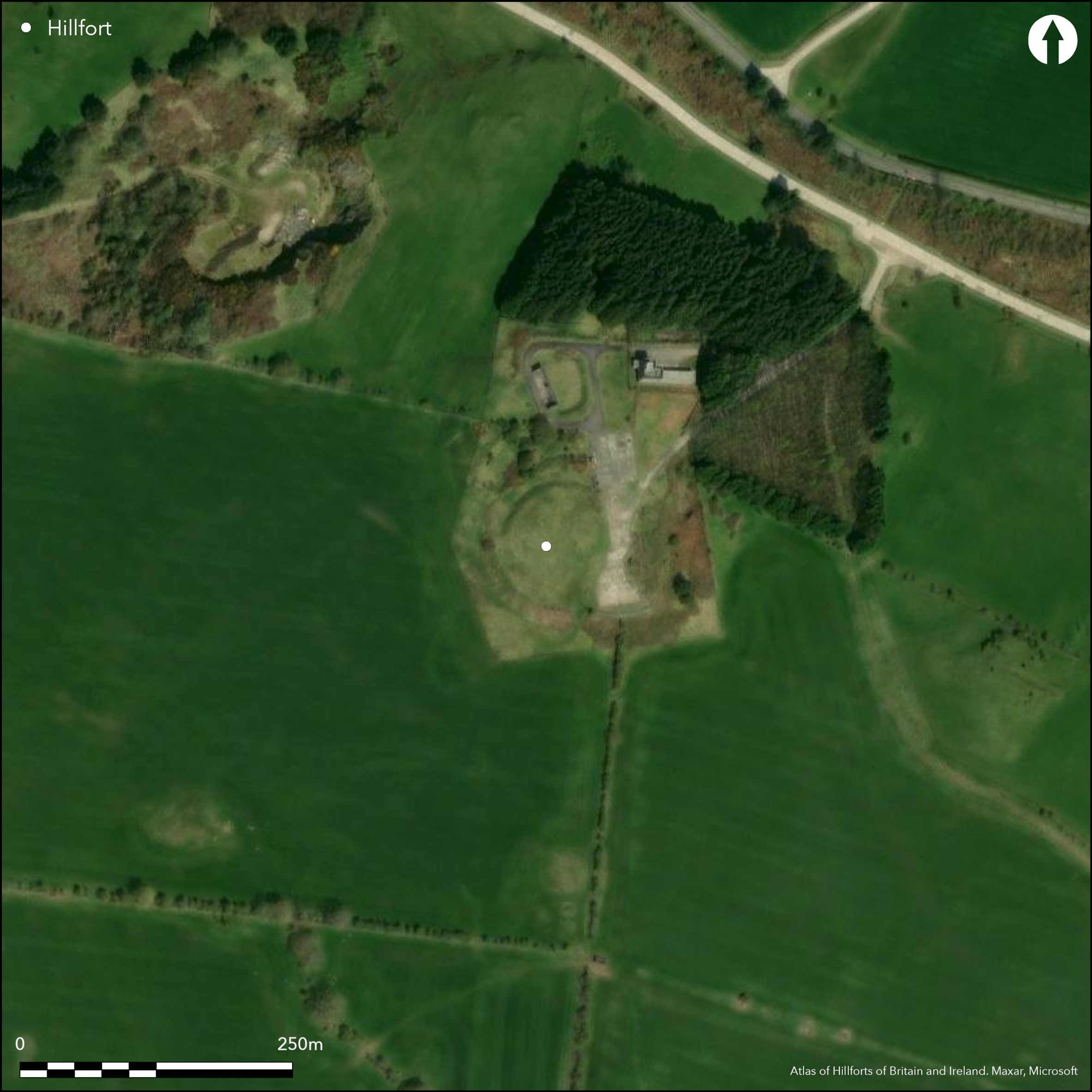
The fort on the summit of Doon Hill is slightly oval on plan, measuring about 56m from NE to SW by 50m transversely (2.2ha) within twin ramparts with external ditches. These have been heavily reduced, initially by cultivation, but more recently by the construction of a tank firing-platform on the E side of the defences; this also impinges on this side of the interior. Elsewhere around the western half of the circuit the inner ditch and elements of the two ramparts remain visible, the ditch measuring up to 7m in breadth. The presence of an outer ditch, which was hinted at by the suggestion by the OS in 1971 that there were traces of a third rampart on the N, was only revealed by excavation in the destroyed eastern sector, where both were shown to be rock-cut, a little over 11m apart. The interior, which was under cultivation when it was visited by RCAHMS in 1911, is featureless. The position of the entrance is not known.
Citizen Science: ✗
Reliability of Data: Confirmed
Reliability of Interpretation: Confirmed
X: -444630 Y: 7323330 (EPSG: 3857)
Longitude: -3.994177213994833 Latitude: 54.800947379953534 (EPSG:4326)
Country: Scotland
Current County or Unitary Authority: Dumfries & Galloway
Historic County: Kirkcudbrightshire
Current Parish/Community/Council/Townland: Rerrick
None
| Extant | ✓ |
| Cropmark | ✗ |
| Likely Destroyed | ✓ |
None
| Woodland | ✗ |
| Commercial Forestry Plantation | ✗ |
| Parkland | ✗ |
| Pasture (Grazing) | ✓ |
| Arable | ✗ |
| Scrub/Bracken | ✗ |
| Bare Outcrop | ✗ |
| Heather/Moorland | ✗ |
| Heath | ✗ |
| Built-up | ✗ |
| Coastal Grassland | ✗ |
| Other | ✗ |
None
| Contour Fort | ✓ |
| Partial Contour Fort | ✗ |
| Promontory Fort | ✗ |
| Hillslope Fort | ✗ |
| Level Terrain Fort | ✗ |
| Marsh Fort | ✗ |
| Multiple Enclosure Fort | ✗ |
| Hilltop | ✓ |
| Coastal Promontory | ✗ |
| Inland Promontory | ✗ |
| Valley Bottom | ✗ |
| Knoll/Hillock/Outcrop | ✗ |
| Ridge | ✗ |
| Cliff/Plateau-edge/Scarp | ✗ |
| Hillslope | ✗ |
| Lowland | ✗ |
| Spur | ✗ |
Dominant Topographic Feature: None
| North | ✗ |
| Northeast | ✗ |
| East | ✗ |
| Southeast | ✗ |
| South | ✗ |
| Southwest | ✗ |
| West | ✗ |
| Northwest | ✗ |
| Level | ✓ |
Altitude: 105.0m
N/A
There are neither stratified artefacts nor radiocarbon dates to provide a chronology for the defences.
Reliability: D - None
| Pre 1200BC | ✗ |
| 1200BC - 800BC | ✗ |
| 800BC - 400BC | ✗ |
| 400BC - AD50 | ✗ |
| AD50 - AD400 | ✗ |
| AD400 - AD 800 | ✗ |
| Post AD800 | ✗ |
| Unknown | ✓ |
| Pre Hillfort: | None |
| Post Hillfort: | None |
First depicted on John Ainslie's map of The Stewartry of Kircudbrightshire, and annotated 'Camp' on John Thomson's map of Kirkcudbrightshire (1821), it is shown in greater detail in 1849-50 on the 1st edition OS 6-inch map (Kirkcudbrightshire 1854, sheet 55). Noted by Frederick Coles in 1890 (1891, 363), it is also described in the County Inventory for The Stewartry (RCAHMS 1914, 238, no.419). It was re-surveyed by the OS at 1:2500 in 1971, and mapped by RCAHMS again in 2003. Excavation of a section across the E defences took place in 1981
| 1st Identified Map Depiction (1797): | John Ainslie's map of The Stewartry of Kircudbrightshire |
| Other (1850): | Annotated Fort on the 1st edition OS 6-inch map (Kirkcudbrightshire 1854, sheet 55) |
| Other (1890): | Description (Coles 1891, 363) |
| Other (1911): | Description (RCAHMS 1914, 238, no.419) |
| Other (1937): | Scheduled |
| Other (1971): | Resurveyed at 1:2500 by the OS |
| Excavation (1981): | Section (Crone 1981) |
| Other (2003): | Visited by RCAHMS |
Featureless
None
| None | ✓ |
| Spring | ✗ |
| Stream | ✗ |
| Pool | ✗ |
| Flush | ✗ |
| Well | ✗ |
| Other | ✗ |
None
| No Known Features | ✓ |
| Round Stone Structures | ✗ |
| Rectangular Stone Structures | ✗ |
| Curvilinear Platforms | ✗ |
| Other Roundhouse Evidence | ✗ |
| Pits | ✗ |
| Quarry Hollows | ✗ |
| Other | ✗ |
None
| No Known Excavation | ✓ |
| Pits | ✗ |
| Postholes | ✗ |
| Roundhouses | ✗ |
| Rectangular Structures | ✗ |
| Roads/Tracks | ✗ |
| Quarry Hollows | ✗ |
| Other | ✗ |
| Nothing Found | ✗ |
None
| No Known Geophysics | ✓ |
| Pits | ✗ |
| Roundhouses | ✗ |
| Rectangular Structures | ✗ |
| Roads/Tracks | ✗ |
| Quarry Hollows | ✗ |
| Other | ✗ |
| Nothing Found | ✗ |
None
| No Known Finds | ✓ |
| Pottery | ✗ |
| Metal | ✗ |
| Metalworking | ✗ |
| Human Bones | ✗ |
| Animal Bones | ✗ |
| Lithics | ✗ |
| Environmental | ✗ |
| Other | ✗ |
None
| APs Not Checked | ✗ |
| None | ✓ |
| Roundhouses | ✗ |
| Rectangular Structures | ✗ |
| Pits | ✗ |
| Postholes | ✗ |
| Roads/Tracks | ✗ |
| Other | ✗ |
None known
| 0: | None |
| 2: | None known |
Guard Chambers: ✗
Chevaux de Frise: ✗
Twin ramparts with external ditches
| Area 1: | 0.22ha. |
| Total: | 0.22ha. |
Total Footprint Area: 0.9ha.
None
| ✗ | None |
| ✓ | Possible third on N |
| NE Quadrant: | 2 |
| SE Quadrant: | 2 |
| SW Quadrant: | 2 |
| NW Quadrant: | 2 |
| Total: | 2 |
| Partial Univallate | ✗ |
| Univallate | ✗ |
| Partial Bivallate | ✗ |
| Bivallate | ✓ |
| Partial Multivallate | ✗ |
| Multivallate | ✗ |
| Unknown | ✗ |
| Partial Univallate | ✗ |
| Univallate | ✗ |
| Partial Bivallate | ✗ |
| Bivallate | ✗ |
| Partial Multivallate | ✗ |
| Multivallate | ✗ |
None
| None | ✗ |
| Earthen Bank | ✓ |
| Stone Wall | ✗ |
| Rubble | ✗ |
| Wall-walk | ✗ |
| Evidence of Timber | ✗ |
| Vitrification | ✗ |
| Other Burning | ✗ |
| Palisade | ✗ |
| Counter Scarp Bank | ✗ |
| Berm | ✗ |
| Unfinished | ✗ |
| Other | ✗ |
None
| None | ✗ |
| Earthen Bank | ✓ |
| Stone Wall | ✗ |
| Murus Duplex | ✗ |
| Timber-framed | ✗ |
| Timber-laced | ✗ |
| Vitrification | ✗ |
| Other Burning | ✗ |
| Palisade | ✗ |
| Counter Scarp Bank | ✗ |
| Berm | ✗ |
| Unfinished | ✗ |
| No Known Excavation | ✗ |
| Other | ✗ |
| ✗ | None |
| ✓ | Disimilar fills possibly suggesting different phases |
Number of Ditches: 2
| ✗ | None |
Coles, F R (1891) The motes, forts, and doons of The Stewartry of Kirkcudbright (Part I). Proc Soc Antiq Scotland 25, 352-96
Crone, A (1981) 'Doonhill (Rerrick p), hillfort', Disc Exc Scot 1981, 8-9
RCAHMS (1914) The Royal Commission on the Ancient and Historical Monuments and Constructions of Scotland. Fifth report and inventory of monuments and constructions in Galloway, II, county of the Stewartry of Kirkcudbright, Edinburgh
Atlas of Hillforts:
Wikidata:
This work is licensed under CC BY-SA 4.0![]()
![]()
![]() and should be cited as:
and should be cited as:
Lock, Gary and Ralston, Ian. 2024. Atlas of Hillforts of Britain and Ireland. Available at: https://hillforts.arch.ox.ac.uk
Document Version 1.1