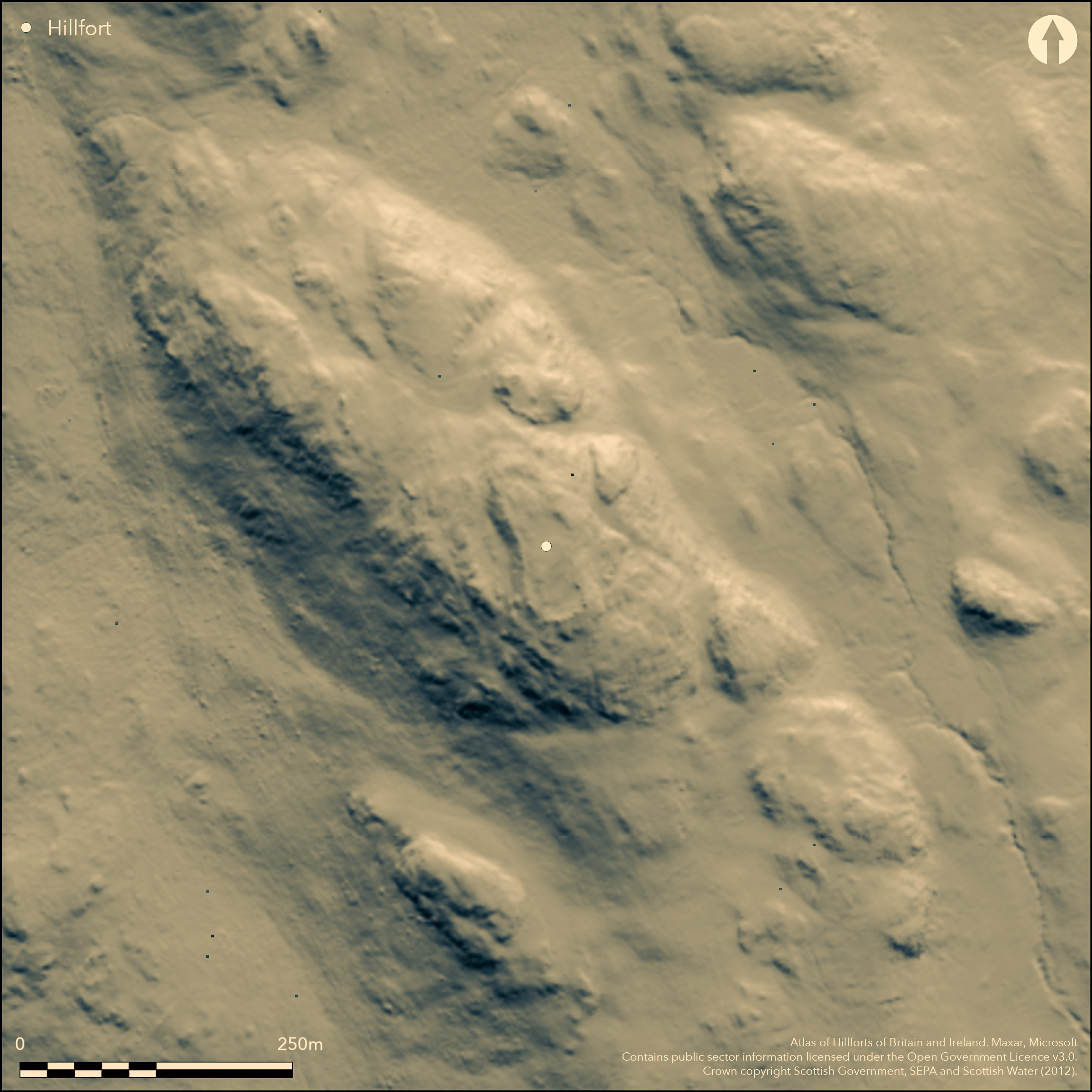
LiDAR 1m DTM Hillshade

Satellite Imagery
LiDAR 1m DTM Hillshade
Satellite Imagery
Scroll left/right to view further images.
HER: Dumfries & Galloway MDG4111 (None)
NMR: NX 75 SE 2 (64525)
SM: 1096
NGR: NX 7658 5081
X: 276580 Y: 550810 (OSGB36)
This fort occupies the rugged rocky summit of Suie Hill, a prominent hill overlooking the coastal lowlands stretching westwards from Auchencairn Bay. Its defences are heavily ruined, comprising an inner wall enclosing the very summit of the hill, and an outer wall taking in a lower terrace up to 15m broad along its W flank. The oblong inner enclosure measures about 78m from NNW to SSE by a maximum of 28m transversely (0.19ha), and while the debris from its wall is spread up to 10m, where both faces are visible at the S end it is about 3.5m thick. A narrow entrance on the NNW is flanked by banks of rubble, the western of which swings round to the W to enclose a lower terrace some 15m broad that extends along this side of the fort to take in an additional area of about 0.11ha; this wall, which peters out southwards, forms a substantial band of rubble facing towards the N and NW, where it was originally about 1.8m in thickness. There is no entrance from the interior of the fort into this annex, and while the RCAHMS investigators suggested that there was an entrance on the W, in 1977 the OS suggested that this was modern and identified a gap between the outcrops at its S end as a more likely point of access. The interiors of both the fort and the annexe are featureless, but a series of rectangular structures overlie the wall of the annex on the NW.
Citizen Science: ✗
Reliability of Data: Confirmed
Reliability of Interpretation: Confirmed
X: -436731 Y: 7330272 (EPSG: 3857)
Longitude: -3.923225153904384 Latitude: 54.83687762223671 (EPSG:4326)
Country: Scotland
Current County or Unitary Authority: Dumfries & Galloway
Historic County: Kirkcudbrightshire
Current Parish/Community/Council/Townland: Rerrick
None
| Extant | ✓ |
| Cropmark | ✗ |
| Likely Destroyed | ✗ |
None
| Woodland | ✗ |
| Commercial Forestry Plantation | ✗ |
| Parkland | ✗ |
| Pasture (Grazing) | ✓ |
| Arable | ✗ |
| Scrub/Bracken | ✗ |
| Bare Outcrop | ✗ |
| Heather/Moorland | ✓ |
| Heath | ✗ |
| Built-up | ✗ |
| Coastal Grassland | ✗ |
| Other | ✗ |
None
| Contour Fort | ✓ |
| Partial Contour Fort | ✗ |
| Promontory Fort | ✗ |
| Hillslope Fort | ✗ |
| Level Terrain Fort | ✗ |
| Marsh Fort | ✗ |
| Multiple Enclosure Fort | ✗ |
| Hilltop | ✓ |
| Coastal Promontory | ✗ |
| Inland Promontory | ✗ |
| Valley Bottom | ✗ |
| Knoll/Hillock/Outcrop | ✗ |
| Ridge | ✗ |
| Cliff/Plateau-edge/Scarp | ✗ |
| Hillslope | ✗ |
| Lowland | ✗ |
| Spur | ✗ |
Dominant Topographic Feature: None
| North | ✗ |
| Northeast | ✗ |
| East | ✗ |
| Southeast | ✗ |
| South | ✗ |
| Southwest | ✗ |
| West | ✗ |
| Northwest | ✗ |
| Level | ✓ |
Altitude: 245.0m
N/A
In the absence of excavation, there are neither stratified artefacts nor radiocarbon dates to provide a chronology for the defences.
Reliability: D - None
| Pre 1200BC | ✗ |
| 1200BC - 800BC | ✗ |
| 800BC - 400BC | ✗ |
| 400BC - AD50 | ✗ |
| AD50 - AD400 | ✗ |
| AD400 - AD 800 | ✗ |
| Post AD800 | ✗ |
| Unknown | ✓ |
| Pre Hillfort: | None |
| Post Hillfort: | Overlain by rectangular structures considered by the OS to be shielings |
First depicted by John Ainslie on his map of The Stewartry of Kirkcudbright (1797), it was shown in greater detail in 1849 on the 1st edition OS 6-inch map (Kirkcudbrightshire 1854, sheet 51), on which the annexe is shown as annotated 'Old Fence'. It was sketch-planned by Frederick Coles about 1891 (1892, 117-20, figs 34-7), and surveyed in 1911 for the County Inventory for The Stewartry (RCAHMS 1914, 231-3, no. 407, fig 166). Subsequently revisited by RCAHMS in 1952, it was re-surveyed by the OS in 1971 at 1:2500, and in 1977 at 1:10,000. It was photographed from the air by RCAHMS in 2001.
| 1st Identified Map Depiction (1797): | John Ainslie on his map of The Stewartry of Kirkcudbright (1797) |
| Other (1849): | Named Suie Moat in Gothic type on the 1st edition OS 6-inch map (Kirkcudbrightshire 1854, sheet 51) |
| Earthwork Survey (1891): | Sketch-plan and description (Coles 1892, 117-20, figs 34-7) |
| Earthwork Survey (1911): | Measured plan and description (RCAHMS 1914, 231-3, no. 407, fig 166) |
| Other (1952): | Description during RCAHMS Survey of Marginal Lands |
| Other (1962): | Scheduled |
| Other (1971): | Resurveyed at 1:2500 by the OS |
| Other (1977): | Surveyed at 1:10.000 by the OS |
Featureless
None
| None | ✓ |
| Spring | ✗ |
| Stream | ✗ |
| Pool | ✗ |
| Flush | ✗ |
| Well | ✗ |
| Other | ✗ |
None
| No Known Features | ✓ |
| Round Stone Structures | ✗ |
| Rectangular Stone Structures | ✗ |
| Curvilinear Platforms | ✗ |
| Other Roundhouse Evidence | ✗ |
| Pits | ✗ |
| Quarry Hollows | ✗ |
| Other | ✗ |
None
| No Known Excavation | ✓ |
| Pits | ✗ |
| Postholes | ✗ |
| Roundhouses | ✗ |
| Rectangular Structures | ✗ |
| Roads/Tracks | ✗ |
| Quarry Hollows | ✗ |
| Other | ✗ |
| Nothing Found | ✗ |
None
| No Known Geophysics | ✓ |
| Pits | ✗ |
| Roundhouses | ✗ |
| Rectangular Structures | ✗ |
| Roads/Tracks | ✗ |
| Quarry Hollows | ✗ |
| Other | ✗ |
| Nothing Found | ✗ |
None
| No Known Finds | ✓ |
| Pottery | ✗ |
| Metal | ✗ |
| Metalworking | ✗ |
| Human Bones | ✗ |
| Animal Bones | ✗ |
| Lithics | ✗ |
| Environmental | ✗ |
| Other | ✗ |
None
| APs Not Checked | ✗ |
| None | ✓ |
| Roundhouses | ✗ |
| Rectangular Structures | ✗ |
| Pits | ✗ |
| Postholes | ✗ |
| Roads/Tracks | ✗ |
| Other | ✗ |
See main summary
| 3: | One into the fort; two into the annex |
| 2: | None |
Guard Chambers: ✗
Chevaux de Frise: ✗
| 1. Passage-way/Corridor (North): | None |
Univallate fort with outer rampart enclosing an Annex on the W
| Area 1: | 0.19ha. |
| Area 2: | 0.3ha. |
| Total: | 0.3ha. |
Total Footprint Area: 0.5ha.
None
| ✗ | None |
| ✓ | None |
| NE Quadrant: | 1 |
| SE Quadrant: | 1 |
| SW Quadrant: | 2 |
| NW Quadrant: | 2 |
| Total: | 2 |
| Partial Univallate | ✓ |
| Univallate | ✗ |
| Partial Bivallate | ✓ |
| Bivallate | ✗ |
| Partial Multivallate | ✗ |
| Multivallate | ✗ |
| Unknown | ✗ |
| Partial Univallate | ✗ |
| Univallate | ✓ |
| Partial Bivallate | ✗ |
| Bivallate | ✗ |
| Partial Multivallate | ✗ |
| Multivallate | ✗ |
None
| None | ✗ |
| Earthen Bank | ✗ |
| Stone Wall | ✓ |
| Rubble | ✗ |
| Wall-walk | ✗ |
| Evidence of Timber | ✗ |
| Vitrification | ✗ |
| Other Burning | ✗ |
| Palisade | ✗ |
| Counter Scarp Bank | ✗ |
| Berm | ✗ |
| Unfinished | ✗ |
| Other | ✗ |
None
| None | ✗ |
| Earthen Bank | ✗ |
| Stone Wall | ✗ |
| Murus Duplex | ✗ |
| Timber-framed | ✗ |
| Timber-laced | ✗ |
| Vitrification | ✗ |
| Other Burning | ✗ |
| Palisade | ✗ |
| Counter Scarp Bank | ✗ |
| Berm | ✗ |
| Unfinished | ✗ |
| No Known Excavation | ✓ |
| Other | ✗ |
| ✗ | None |
| ✗ | None |
Number of Ditches: None
| ✓ | The outer wall of this fort takes in a terrace below the summit on the W side of the fort to enclose an additional 0.11ha. It has an independent entrance, probably through a gap in the outcrops at its S end. The interior is featureless. |
Coles, F R (1892) 'The Motes, Forts, and Doons of the Stewartry of Kirkcudbrightshire. (Part II)' Proc Soc Antiq Scot 26, 117-70
RCAHMS (1914) The Royal Commission on the Ancient and Historical Monuments and Constructions of Scotland. Fifth report and inventory of monuments and constructions in Galloway, II, county of the Stewartry of Kirkcudbright, Edinburgh
Atlas of Hillforts:
Wikidata:
This work is licensed under CC BY-SA 4.0![]()
![]()
![]() and should be cited as:
and should be cited as:
Lock, Gary and Ralston, Ian. 2024. Atlas of Hillforts of Britain and Ireland. Available at: https://hillforts.arch.ox.ac.uk
Document Version 1.1