Satellite Imagery
Satellite Imagery
HER: Dumfries & Galloway MDG4112 (None)
NMR: NX 75 SE 3 (64526)
SM: 1070
NGR: NX 7575 5360
X: 275750 Y: 553600 (OSGB36)
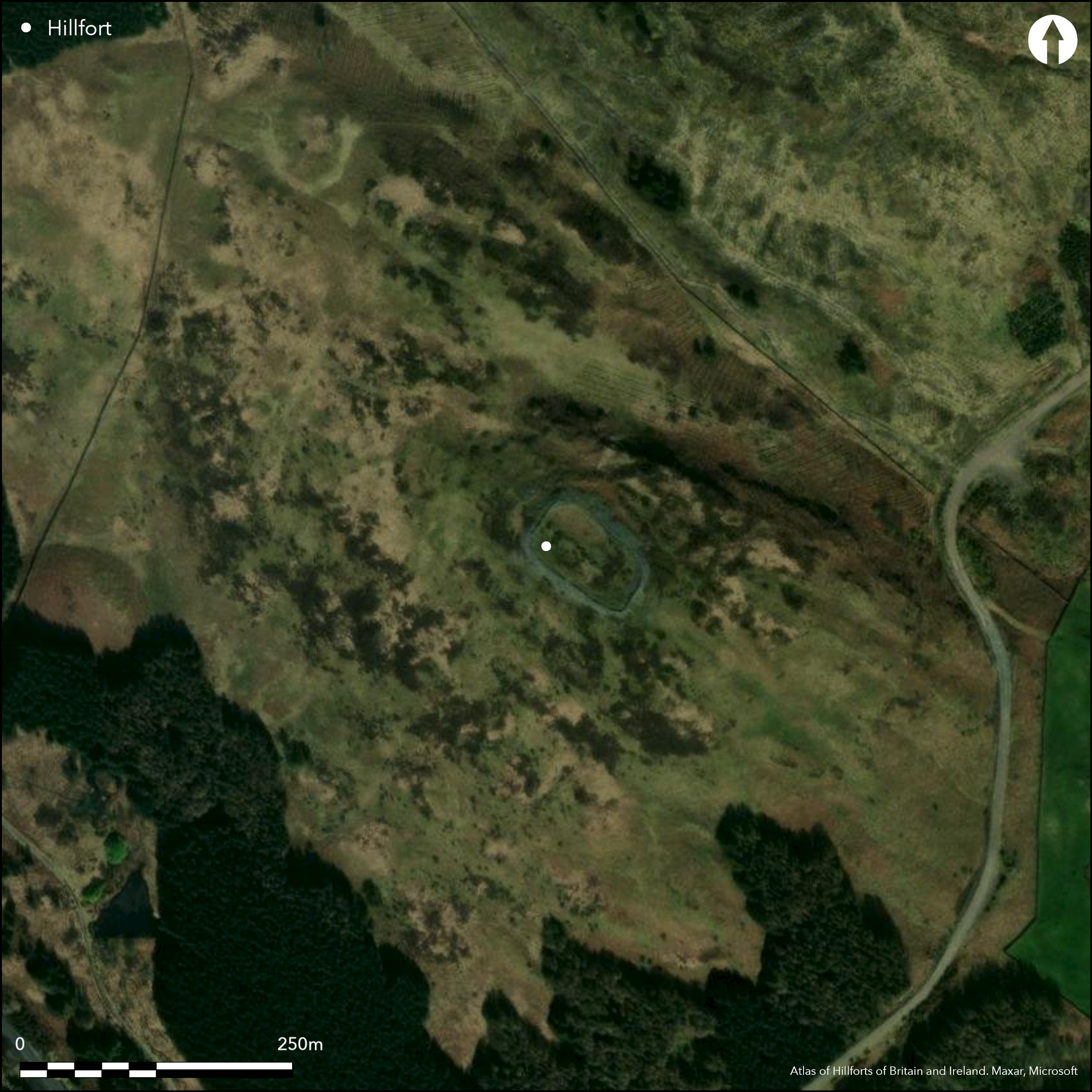
This fort sub-rectangular occupies the summit of a rocky hill and measures 63m from NW to SE by up to 37m transversely (0.2ha) within two roughly concentric walls about 7m apart. The inner, which forms a band of rubble between 6m and 9m thick and is overlain by a later plantation enclosure, is about 3.5m in thickness and the outer probably about 1.8m. On the NE, enclosing a terrace between the outer wall and the edge of a cliff on this flank, there is an annex measuring some 57m from NW to SE by up to 30m transversely within its wall. No entrance into the annex has been noted, but the entrance into the fort itself lies at the NW end, though there is now little evidence of a gap in the inner wall. What has been described as a hornwork is visible outside the gap in the outer wall (Feachem 1963, 130), but in 1977 the OS observed that this bank, which springs from the outer rampart on the W side of the entrance, turns eastwards down the slope, as it was previously shown on the first 25-inch map (Kirkcudbrightshire, 1895, sheet 49.12), and suggested that it might indicate the presence of an outer annex on this side.
Citizen Science: ✗
Reliability of Data: Confirmed
Reliability of Interpretation: Confirmed
X: -438303 Y: 7335077 (EPSG: 3857)
Longitude: -3.9373411347519616 Latitude: 54.86173047805246 (EPSG:4326)
Country: Scotland
Current County or Unitary Authority: Dumfries & Galloway
Historic County: Kirkcudbrightshire
Current Parish/Community/Council/Townland: Rerrick
None
| Extant | ✓ |
| Cropmark | ✗ |
| Likely Destroyed | ✗ |
Large clearing in a plantation
| Woodland | ✗ |
| Commercial Forestry Plantation | ✗ |
| Parkland | ✗ |
| Pasture (Grazing) | ✗ |
| Arable | ✗ |
| Scrub/Bracken | ✓ |
| Bare Outcrop | ✗ |
| Heather/Moorland | ✓ |
| Heath | ✗ |
| Built-up | ✗ |
| Coastal Grassland | ✗ |
| Other | ✗ |
None
| Contour Fort | ✓ |
| Partial Contour Fort | ✗ |
| Promontory Fort | ✗ |
| Hillslope Fort | ✗ |
| Level Terrain Fort | ✗ |
| Marsh Fort | ✗ |
| Multiple Enclosure Fort | ✗ |
| Hilltop | ✓ |
| Coastal Promontory | ✗ |
| Inland Promontory | ✗ |
| Valley Bottom | ✗ |
| Knoll/Hillock/Outcrop | ✗ |
| Ridge | ✗ |
| Cliff/Plateau-edge/Scarp | ✗ |
| Hillslope | ✗ |
| Lowland | ✗ |
| Spur | ✗ |
Dominant Topographic Feature: None
| North | ✗ |
| Northeast | ✗ |
| East | ✗ |
| Southeast | ✗ |
| South | ✗ |
| Southwest | ✗ |
| West | ✗ |
| Northwest | ✗ |
| Level | ✓ |
Altitude: 225.0m
N/A
In the absence of excavation, there are neither stratified artefacts nor radiocarbon dates to provide a chronology for the defences.
Reliability: D - None
| Pre 1200BC | ✗ |
| 1200BC - 800BC | ✗ |
| 800BC - 400BC | ✗ |
| 400BC - AD50 | ✗ |
| AD50 - AD400 | ✗ |
| AD400 - AD 800 | ✗ |
| Post AD800 | ✗ |
| Unknown | ✓ |
| Pre Hillfort: | None |
| Post Hillfort: | Utilised for a post-medieval plantation enclosure |
First shown by John Ainslie on his map of The Stewartry of Kirkcudbright (1797), in 1848-9 it was outlined in some detail on the 1st edition OS 6-inch map (Kirkcudbrightshire 1853, sheet 45). Sketch-planned by Frederick Coles in 1890 (1891, 393-6, figs 32-3), a measured plan was drawn up in 1911 by RCAHMS for the County Inventory for The Stewartry (RCAHMS 1914, 230-1, fig 165). Revisited by RCAHMS in 1952, it was also photographed from the air by RCAHMS in 2001. The OS visited the fort in 1977.
| 1st Identified Map Depiction (1797): | John Ainslie's map of The Stewartry of Kirkcudbright (1797) |
| Other (1849): | Named Dungarry Camp on the 1st edition OS 6-inch map (Kirkcudbrightshire 1853, sheet 45) |
| Earthwork Survey (1890): | Sketch-plan and description (Coles 1891, 393-6, figs 32-3) |
| Earthwork Survey (1911): | Measured Survey (RCAHMS 1914 230-1, fig 165) |
| Other (1938): | Scheduled |
| Other (1952): | Description during RCAHMS Survey of Marginal Lands |
| Other (1977): | Surveyed at 1:10.000 by the OS |
Featureless
None
| None | ✓ |
| Spring | ✗ |
| Stream | ✗ |
| Pool | ✗ |
| Flush | ✗ |
| Well | ✗ |
| Other | ✗ |
None
| No Known Features | ✓ |
| Round Stone Structures | ✗ |
| Rectangular Stone Structures | ✗ |
| Curvilinear Platforms | ✗ |
| Other Roundhouse Evidence | ✗ |
| Pits | ✗ |
| Quarry Hollows | ✗ |
| Other | ✗ |
None
| No Known Excavation | ✓ |
| Pits | ✗ |
| Postholes | ✗ |
| Roundhouses | ✗ |
| Rectangular Structures | ✗ |
| Roads/Tracks | ✗ |
| Quarry Hollows | ✗ |
| Other | ✗ |
| Nothing Found | ✗ |
None
| No Known Geophysics | ✓ |
| Pits | ✗ |
| Roundhouses | ✗ |
| Rectangular Structures | ✗ |
| Roads/Tracks | ✗ |
| Quarry Hollows | ✗ |
| Other | ✗ |
| Nothing Found | ✗ |
None
| No Known Finds | ✓ |
| Pottery | ✗ |
| Metal | ✗ |
| Metalworking | ✗ |
| Human Bones | ✗ |
| Animal Bones | ✗ |
| Lithics | ✗ |
| Environmental | ✗ |
| Other | ✗ |
None
| APs Not Checked | ✗ |
| None | ✓ |
| Roundhouses | ✗ |
| Rectangular Structures | ✗ |
| Pits | ✗ |
| Postholes | ✗ |
| Roads/Tracks | ✗ |
| Other | ✗ |
See main summary
| 1: | None |
| 2: | None |
Guard Chambers: ✗
Chevaux de Frise: ✗
| 1. Simple Gap (North west): | Supposedly protected by a hornwork, but more probably part of an outer defence or annex |
Twin stone walls round the inner enclosure, with single wall around annex on the NE.
| Area 1: | 0.2ha. |
| Total: | 0.2ha. |
Total Footprint Area: 0.7ha.
None
| ✗ | None |
| ✓ | None |
| NE Quadrant: | 2 |
| SE Quadrant: | 2 |
| SW Quadrant: | 2 |
| NW Quadrant: | 2 |
| Total: | 2 |
| Partial Univallate | ✗ |
| Univallate | ✗ |
| Partial Bivallate | ✗ |
| Bivallate | ✓ |
| Partial Multivallate | ✗ |
| Multivallate | ✗ |
| Unknown | ✗ |
| Partial Univallate | ✗ |
| Univallate | ✗ |
| Partial Bivallate | ✗ |
| Bivallate | ✗ |
| Partial Multivallate | ✗ |
| Multivallate | ✗ |
None
| None | ✗ |
| Earthen Bank | ✗ |
| Stone Wall | ✓ |
| Rubble | ✗ |
| Wall-walk | ✗ |
| Evidence of Timber | ✗ |
| Vitrification | ✗ |
| Other Burning | ✗ |
| Palisade | ✗ |
| Counter Scarp Bank | ✗ |
| Berm | ✗ |
| Unfinished | ✗ |
| Other | ✗ |
None
| None | ✗ |
| Earthen Bank | ✗ |
| Stone Wall | ✗ |
| Murus Duplex | ✗ |
| Timber-framed | ✗ |
| Timber-laced | ✗ |
| Vitrification | ✗ |
| Other Burning | ✗ |
| Palisade | ✗ |
| Counter Scarp Bank | ✗ |
| Berm | ✗ |
| Unfinished | ✗ |
| No Known Excavation | ✓ |
| Other | ✗ |
| ✗ | None |
| ✗ | None |
Number of Ditches: None
| ✓ | An annex extends down to a cliff-edge on the NE to enclose an area of about 0.13ha. No entrances into the annex have been noted and its interior is featureless. The OS suggest that the supposed hornwork around the entrance to the fort may be part of a second annex on this side |
Coles, F R (1891) The motes, forts, and doons of The Stewartry of Kirkcudbright. Proc Soc Antiq Scotland 25, 352-96
Feachem, R (1963b) A guide to prehistoric Scotland, London (p 130)
RCAHMS (1914) The Royal Commission on the Ancient and Historical Monuments and Constructions of Scotland. Fifth report and inventory of monuments and constructions in Galloway, II, county of the Stewartry of Kirkcudbright, Edinburgh
Atlas of Hillforts:
Wikidata:
This work is licensed under CC BY-SA 4.0![]()
![]()
![]() and should be cited as:
and should be cited as:
Lock, Gary and Ralston, Ian. 2024. Atlas of Hillforts of Britain and Ireland. Available at: https://hillforts.arch.ox.ac.uk
Document Version 1.1