LiDAR 1m DTM Hillshade
Satellite Imagery
LiDAR 1m DTM Hillshade
Satellite Imagery
Scroll left/right to view further images.
HER: Dumfries & Galloway MDG4355 (None)
NMR: NX 78 SE 1 (64780)
SM: None
NGR: NX 7586 8419
X: 275860 Y: 584190 (OSGB36)
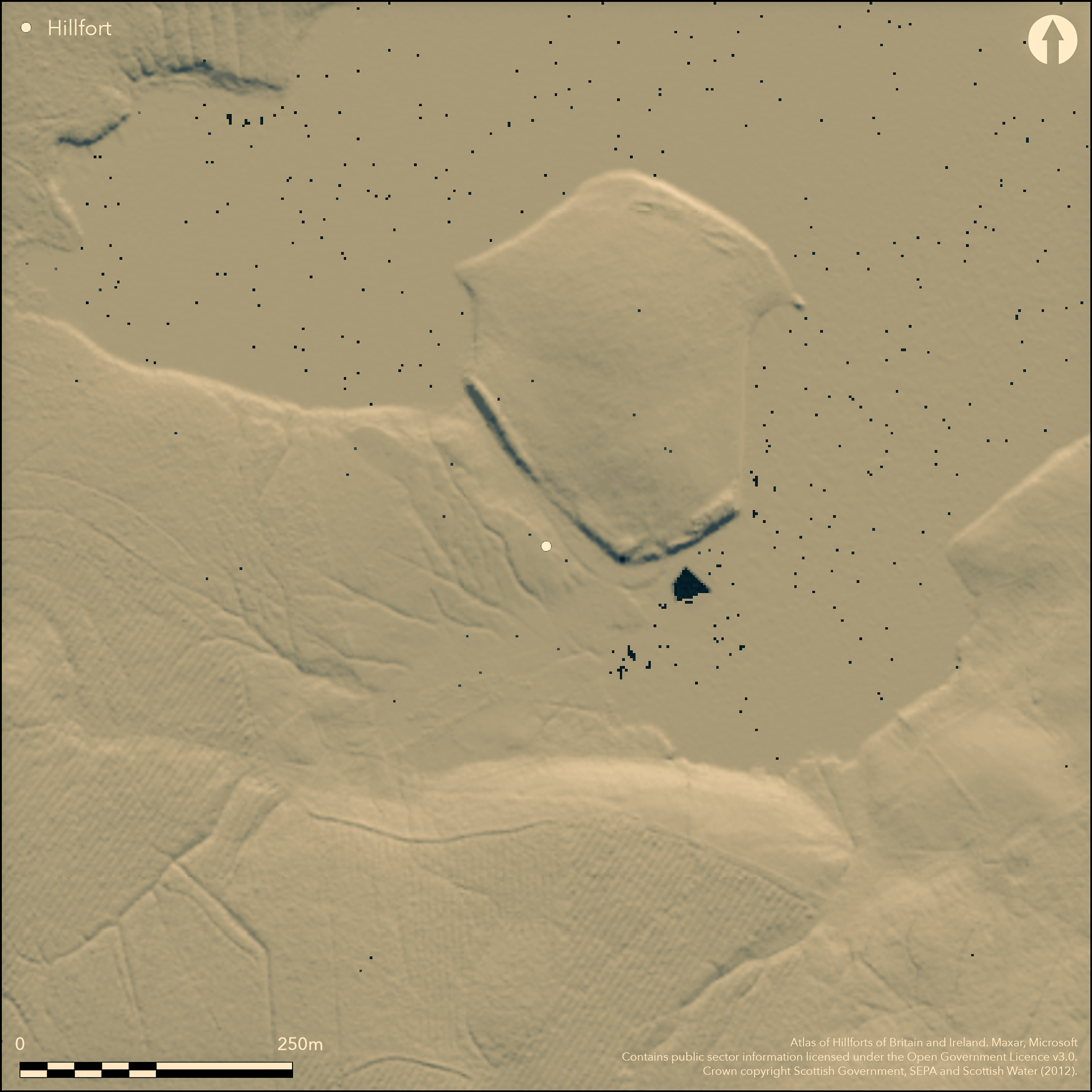
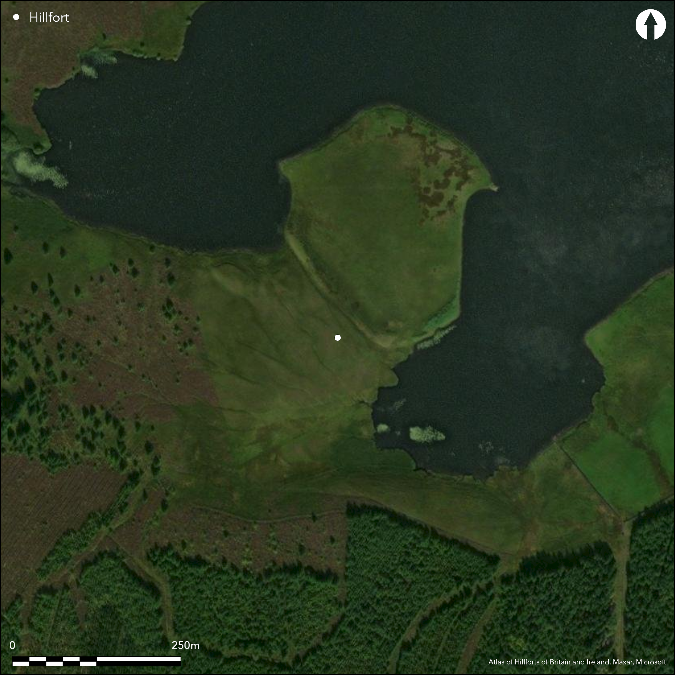
Access to a low-lying promontory which projects into Loch Urr from the SW shore is cut off by a substantial earthwork. Measuring some 140m from NW to SE at the neck, by 140m transversely, the interior is an irregular hexagon of about 2.4ha on plan. The bank is best preserved at the NW end, where it stands 1m high internally and 3m above the bottom of the external ditch, which is up to 15m in breadth and at least 1.5m in depth. About 1906 John Corrie cut two sections across the defences, revealing that the core of the rampart was a bank of clay and gravel up to 2m high and that the sediment had filled the ditch to a depth of about 1.7m; a rough stone pavement 3m broad was found to the rear of the rampart. A broad gap in the centre may indicate the position of the entrance, although it may have been broadened by later traffic. The only features visible in the interior are two rectangular buildings lying at the N tip of the promontory, but in 1971 the upper stone of a rotary quern was found on the promontory (Truckell 1972).
Citizen Science: ✗
Reliability of Data: Confirmed
Reliability of Interpretation: Confirmed
X: -439590 Y: 7388402 (EPSG: 3857)
Longitude: -3.948904296699888 Latitude: 55.13649195684544 (EPSG:4326)
Country: Scotland
Current County or Unitary Authority: Dumfries & Galloway
Historic County: Dumfriesshire
Current Parish/Community/Council/Townland: Dunscore
None
| Extant | ✓ |
| Cropmark | ✗ |
| Likely Destroyed | ✗ |
None
| Woodland | ✗ |
| Commercial Forestry Plantation | ✗ |
| Parkland | ✗ |
| Pasture (Grazing) | ✗ |
| Arable | ✗ |
| Scrub/Bracken | ✗ |
| Bare Outcrop | ✗ |
| Heather/Moorland | ✓ |
| Heath | ✗ |
| Built-up | ✗ |
| Coastal Grassland | ✗ |
| Other | ✗ |
None
| Contour Fort | ✗ |
| Partial Contour Fort | ✗ |
| Promontory Fort | ✓ |
| Hillslope Fort | ✗ |
| Level Terrain Fort | ✗ |
| Marsh Fort | ✗ |
| Multiple Enclosure Fort | ✗ |
| Hilltop | ✗ |
| Coastal Promontory | ✗ |
| Inland Promontory | ✓ |
| Valley Bottom | ✗ |
| Knoll/Hillock/Outcrop | ✗ |
| Ridge | ✗ |
| Cliff/Plateau-edge/Scarp | ✗ |
| Hillslope | ✗ |
| Lowland | ✗ |
| Spur | ✗ |
Dominant Topographic Feature: None
| North | ✗ |
| Northeast | ✗ |
| East | ✗ |
| Southeast | ✗ |
| South | ✗ |
| Southwest | ✗ |
| West | ✗ |
| Northwest | ✗ |
| Level | ✓ |
Altitude: 185.0m
N/A
In the absence of modern excavation, there are neither stratified artefacts nor radiocarbon dates to provide a chronology for the defences.
Reliability: D - None
| Pre 1200BC | ✗ |
| 1200BC - 800BC | ✗ |
| 800BC - 400BC | ✗ |
| 400BC - AD50 | ✗ |
| AD50 - AD400 | ✗ |
| AD400 - AD 800 | ✗ |
| Post AD800 | ✗ |
| Unknown | ✓ |
| Pre Hillfort: | None |
| Post Hillfort: | Two rectangular buildings |
The earthwork does not appear on either of the first two editions of the OS 6-inch map, but John Corrie sectioned the perimeter in two places about 1906, and it was noted by RCAHMS for the County Inventory of Dumfriesshire in 1912 (RCAHMS 1920, 59, no.148). Visited by the OS in 1978, the earthwork was surveyed by CFA on behalf of Historic Scotland in 1991.
| Excavation (1906): | Trenches across the perimeter (Corrie 1906) |
| Other (1912): | Description (RCAHMS 1920, 59, no.148) |
| 1st Identified Map Depiction (1978): | Surveyed at 1:10.000 by the OS |
| Earthwork Survey (1991): | CFA (1991; RCAHMS MS625/10 and DC14947) |
Featureless apart from what is probably a later rectangular building
Low-lying promontory into loch
| None | ✓ |
| Spring | ✗ |
| Stream | ✗ |
| Pool | ✗ |
| Flush | ✗ |
| Well | ✗ |
| Other | ✗ |
None
| No Known Features | ✗ |
| Round Stone Structures | ✗ |
| Rectangular Stone Structures | ✓ |
| Curvilinear Platforms | ✗ |
| Other Roundhouse Evidence | ✗ |
| Pits | ✗ |
| Quarry Hollows | ✗ |
| Other | ✗ |
Rampart sectioned and stone pavement found beihind the wall
| No Known Excavation | ✗ |
| Pits | ✗ |
| Postholes | ✗ |
| Roundhouses | ✗ |
| Rectangular Structures | ✗ |
| Roads/Tracks | ✗ |
| Quarry Hollows | ✗ |
| Other | ✓ |
| Nothing Found | ✗ |
None
| No Known Geophysics | ✓ |
| Pits | ✗ |
| Roundhouses | ✗ |
| Rectangular Structures | ✗ |
| Roads/Tracks | ✗ |
| Quarry Hollows | ✗ |
| Other | ✗ |
| Nothing Found | ✗ |
None
| No Known Finds | ✓ |
| Pottery | ✗ |
| Metal | ✗ |
| Metalworking | ✗ |
| Human Bones | ✗ |
| Animal Bones | ✗ |
| Lithics | ✗ |
| Environmental | ✗ |
| Other | ✗ |
None
| APs Not Checked | ✗ |
| None | ✓ |
| Roundhouses | ✗ |
| Rectangular Structures | ✗ |
| Pits | ✗ |
| Postholes | ✗ |
| Roads/Tracks | ✗ |
| Other | ✗ |
See main summary
| 1: | None |
| 2: | None |
Guard Chambers: ✗
Chevaux de Frise: ✗
| 1. Simple Gap (South west): | None |
Rampart and external ditch
| Area 1: | 2.4ha. |
| Total: | 2.4ha. |
Total Footprint Area: Noneha.
None
| ✗ | None |
| ✗ | None |
| NE Quadrant: | 0 |
| SE Quadrant: | 0 |
| SW Quadrant: | 1 |
| NW Quadrant: | 0 |
| Total: | 1 |
| Partial Univallate | ✓ |
| Univallate | ✗ |
| Partial Bivallate | ✗ |
| Bivallate | ✗ |
| Partial Multivallate | ✗ |
| Multivallate | ✗ |
| Unknown | ✗ |
| Partial Univallate | ✗ |
| Univallate | ✗ |
| Partial Bivallate | ✗ |
| Bivallate | ✗ |
| Partial Multivallate | ✗ |
| Multivallate | ✗ |
None
| None | ✗ |
| Earthen Bank | ✓ |
| Stone Wall | ✗ |
| Rubble | ✗ |
| Wall-walk | ✗ |
| Evidence of Timber | ✗ |
| Vitrification | ✗ |
| Other Burning | ✗ |
| Palisade | ✗ |
| Counter Scarp Bank | ✗ |
| Berm | ✗ |
| Unfinished | ✗ |
| Other | ✗ |
None
| None | ✗ |
| Earthen Bank | ✓ |
| Stone Wall | ✗ |
| Murus Duplex | ✗ |
| Timber-framed | ✗ |
| Timber-laced | ✗ |
| Vitrification | ✗ |
| Other Burning | ✗ |
| Palisade | ✗ |
| Counter Scarp Bank | ✗ |
| Berm | ✗ |
| Unfinished | ✗ |
| No Known Excavation | ✗ |
| Other | ✗ |
| ✗ | None |
| ✓ | None |
Number of Ditches: 1
| ✗ | None |
CFA (1991l) 'Craigenvey, Loch Urr (Dunscore parish): cairnfields, White Isle earthwork', Disc Exc Scot 1991, 15
Corrie, J (1906) 'The Loch Urr crannog', Trans Dumfriesshire Galloway Natur Hist Antiq Soc, 2 Ser, 17, 244-5
RCAHMS (1920) The Royal Commission on the Ancient and Historical Monuments and Constructions of Scotland. Seventh report with inventory of monuments and constructions in the county of Dumfries, Edinburgh
Truckell, A E (1972) 'Finds and sites, 1971-72', Trans Dumfriesshire Galloway Natur Hist Antiq Soc, 3 Ser, 49, 127
Atlas of Hillforts:
Wikidata:
This work is licensed under CC BY-SA 4.0![]()
![]()
![]() and should be cited as:
and should be cited as:
Lock, Gary and Ralston, Ian. 2024. Atlas of Hillforts of Britain and Ireland. Available at: https://hillforts.arch.ox.ac.uk
Document Version 1.1