LiDAR 1m DTM Hillshade
Satellite Imagery
LiDAR 1m DTM Hillshade
Satellite Imagery
Scroll left/right to view further images.
HER: Dumfries & Galloway MDG4464 (None)
NMR: NX 85 SE 1 (64891)
SM: 1062
NGR: NX 8541 5242
X: 285410 Y: 552420 (OSGB36)
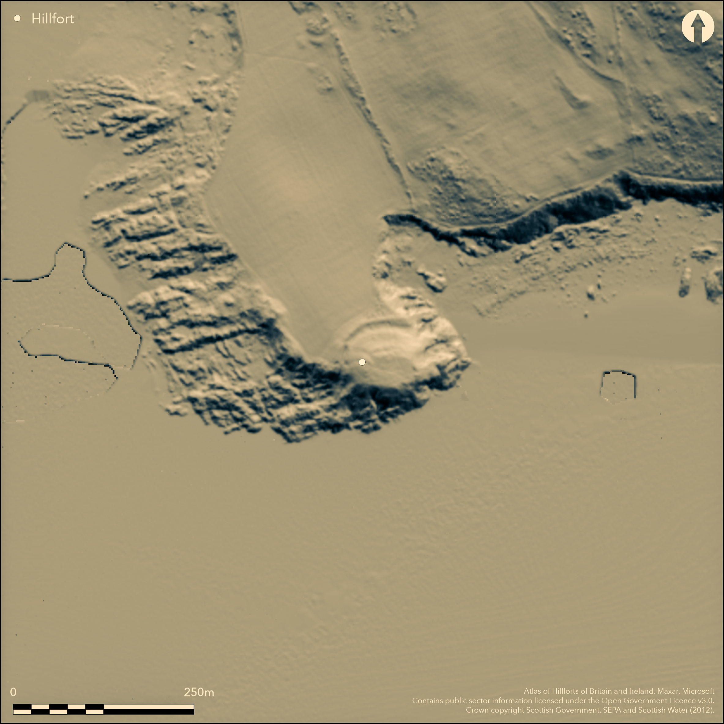
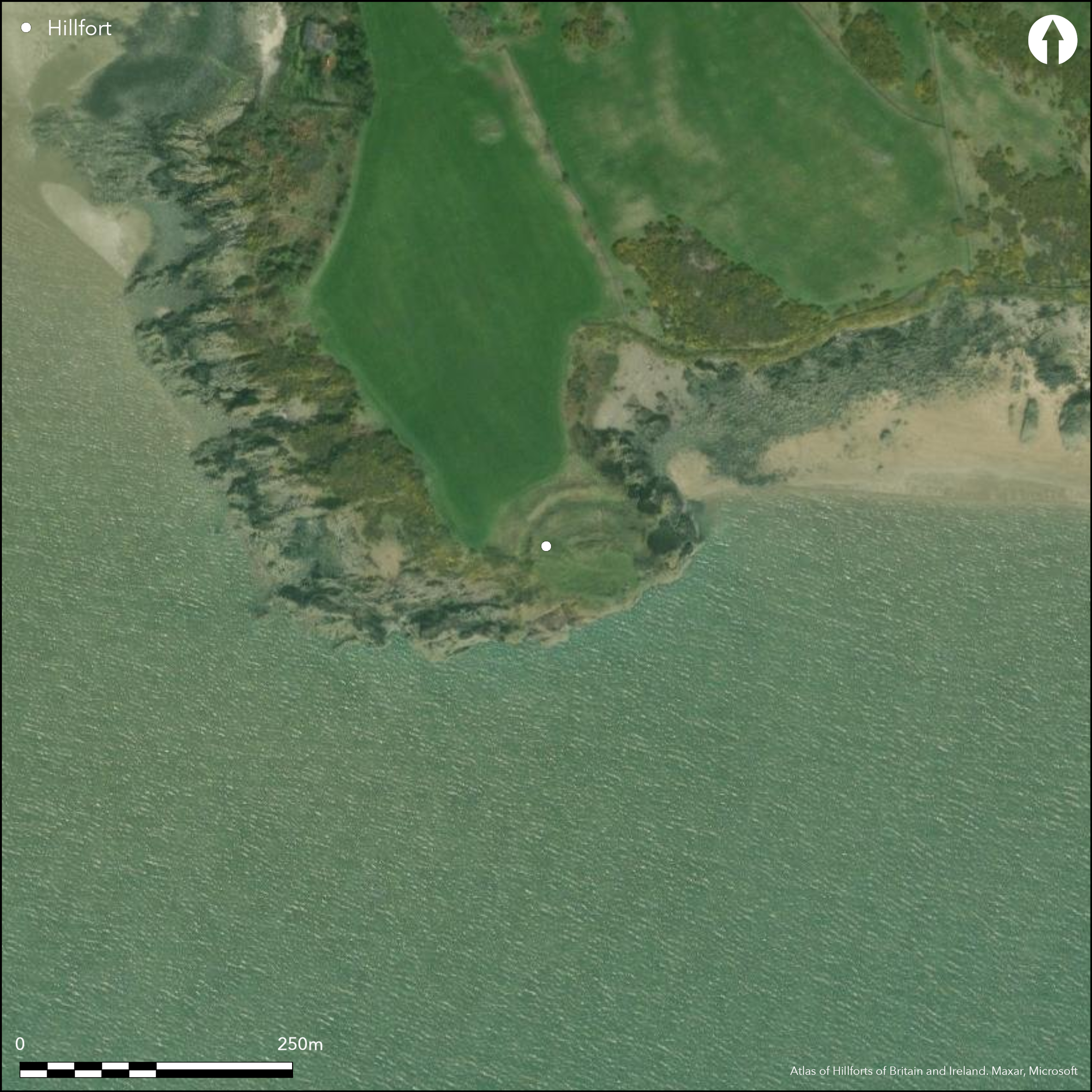
This promontory work is situated on the E of the mouth of the Rough Firth, where the Urr Water flows into the sea. The ground rises into the promontory from the NW and the defences comprise two elements: an inner wall drawn across the top of the promontory, with its ends resting on the cliff-edge to either side; and an outer ditch with an external rampart set towards the foot of the slope. The inner wall probably measures at least 3m in thickness and a long run of the outer face, composed of coursed blocks with pinnings, can be seen standing about 1m in height. Lying some 17m down the rubble strewn slope, the rock-cut ditch measures about 6m in breadth by 1.8m in depth and has a thick external rampart of upcast. A central gap in the rampart on the NW leads up the slope via a causeway across the ditch to an entrance through the inner wall; measuring 2m wide, the alignment of the faces preserved to either side of the entrance passage show that it faces NNW rather than directly NW onto the causeway across the ditch. Set so far apart, it is quite likely that the two lines represent separate schemes for defence, the outer enclosing an area measuring a maximum of 58m from NE to SW by 55m transversely (0.19ha), and the inner an area on the summit 42m by 25m (0.1ha). Sherds from the fort held in the Dumfries Museum have been claimed to be of early medieval date (Feachem 1963, 129).
Citizen Science: ✗
Reliability of Data: Confirmed
Reliability of Interpretation: Confirmed
X: -421506 Y: 7333473 (EPSG: 3857)
Longitude: -3.7864543836511158 Latitude: 54.85343833896437 (EPSG:4326)
Country: Scotland
Current County or Unitary Authority: Dumfries & Galloway
Historic County: Kirkcudbrightshire
Current Parish/Community/Council/Townland: Colvend And Southwick
None
| Extant | ✓ |
| Cropmark | ✗ |
| Likely Destroyed | ✗ |
None
| Woodland | ✗ |
| Commercial Forestry Plantation | ✗ |
| Parkland | ✗ |
| Pasture (Grazing) | ✗ |
| Arable | ✗ |
| Scrub/Bracken | ✗ |
| Bare Outcrop | ✗ |
| Heather/Moorland | ✗ |
| Heath | ✗ |
| Built-up | ✗ |
| Coastal Grassland | ✓ |
| Other | ✗ |
None
| Contour Fort | ✗ |
| Partial Contour Fort | ✗ |
| Promontory Fort | ✓ |
| Hillslope Fort | ✗ |
| Level Terrain Fort | ✗ |
| Marsh Fort | ✗ |
| Multiple Enclosure Fort | ✗ |
| Hilltop | ✗ |
| Coastal Promontory | ✓ |
| Inland Promontory | ✗ |
| Valley Bottom | ✗ |
| Knoll/Hillock/Outcrop | ✗ |
| Ridge | ✗ |
| Cliff/Plateau-edge/Scarp | ✗ |
| Hillslope | ✗ |
| Lowland | ✗ |
| Spur | ✗ |
Dominant Topographic Feature: None
| North | ✗ |
| Northeast | ✗ |
| East | ✗ |
| Southeast | ✗ |
| South | ✗ |
| Southwest | ✗ |
| West | ✗ |
| Northwest | ✗ |
| Level | ✓ |
Altitude: 20.0m
N/A
No modern review of the pottery
Reliability: C - Low
| Pre 1200BC | ✗ |
| 1200BC - 800BC | ✗ |
| 800BC - 400BC | ✗ |
| 400BC - AD50 | ✗ |
| AD50 - AD400 | ✗ |
| AD400 - AD 800 | ✓ |
| Post AD800 | ✗ |
| Unknown | ✓ |
| Pre Hillfort: | None |
| Post Hillfort: | None |
| Artefactual: | Pottery said to be early medieval identified by Charles Thomas in the Dumfries Museum |
Merely named Castle point on Roy's map (1747-55), it is depicted in 1797 and annotated 'Old Fort' on John Ainslie's map of The Stewartry of Kirkcudbright (1797). Depicted in greater detail in 1848-51 on the 1st edition OS 6-inch map (Kirkcudbrightshire 1854, sheet 52), it was sketch-planned and described by Frederick Coles about 1892 (1893, 92-3, fig 1), and surveyed by the OS at 25-inch in 1894 (Kirkcudbrightshire 1894, sheet 50.16). It was described in 1911 for the County Inventory of The Stewartry (RCAHMS 1914, 70, no. 118), and revisited by RCAHMS in 1951. The OS re-surveyed at 1:2500 in 1969, and In 1996 the site was surveyed and evaluated for coastal erosion (Toolis 2003, 59).
| 1st Identified Map Depiction (1797): | John Ainslie's map of The Stewartry of Kirkcudbright (1797) |
| Other (1851): | Annotated Fort on the 1st edition OS 6-inch map (Kirkcudbrightshire 1854, sheet 52) |
| Earthwork Survey (1892): | Sketch-plan and description (Coles 1893, 92-3, fig 1) |
| Other (1911): | Description (RCAHMS 1914, 70, no. 118) |
| Other (1938): | Scheduled |
| Other (1951): | Description during RCAHMS Survey of Marginal Lands |
| Other (1969): | Resurveyed at 1:2500 by the OS |
| Earthwork Survey (1996): | Coastal erosion survey (Toolis 2003, 59) |
No discernible features
None
| None | ✓ |
| Spring | ✗ |
| Stream | ✗ |
| Pool | ✗ |
| Flush | ✗ |
| Well | ✗ |
| Other | ✗ |
None
| No Known Features | ✓ |
| Round Stone Structures | ✗ |
| Rectangular Stone Structures | ✗ |
| Curvilinear Platforms | ✗ |
| Other Roundhouse Evidence | ✗ |
| Pits | ✗ |
| Quarry Hollows | ✗ |
| Other | ✗ |
None
| No Known Excavation | ✓ |
| Pits | ✗ |
| Postholes | ✗ |
| Roundhouses | ✗ |
| Rectangular Structures | ✗ |
| Roads/Tracks | ✗ |
| Quarry Hollows | ✗ |
| Other | ✗ |
| Nothing Found | ✗ |
None
| No Known Geophysics | ✓ |
| Pits | ✗ |
| Roundhouses | ✗ |
| Rectangular Structures | ✗ |
| Roads/Tracks | ✗ |
| Quarry Hollows | ✗ |
| Other | ✗ |
| Nothing Found | ✗ |
None
| No Known Finds | ✗ |
| Pottery | ✓ |
| Metal | ✗ |
| Metalworking | ✗ |
| Human Bones | ✗ |
| Animal Bones | ✗ |
| Lithics | ✗ |
| Environmental | ✗ |
| Other | ✗ |
None
| APs Not Checked | ✗ |
| None | ✓ |
| Roundhouses | ✗ |
| Rectangular Structures | ✗ |
| Pits | ✗ |
| Postholes | ✗ |
| Roads/Tracks | ✗ |
| Other | ✗ |
See main summary
| 1: | None |
| 2: | None |
Guard Chambers: ✗
Chevaux de Frise: ✗
| 1. Simple Gap (North west): | None |
Inner wall with outer ditch and external rampart drawn across the promontory
| Area 1: | 0.1ha. |
| Total: | 0.1ha. |
Total Footprint Area: 0.34ha.
None
| ✗ | Probably multiperiod |
| ✗ | None |
| NE Quadrant: | 0 |
| SE Quadrant: | 0 |
| SW Quadrant: | 0 |
| NW Quadrant: | 2 |
| Total: | 2 |
| Partial Univallate | ✗ |
| Univallate | ✗ |
| Partial Bivallate | ✓ |
| Bivallate | ✗ |
| Partial Multivallate | ✗ |
| Multivallate | ✗ |
| Unknown | ✗ |
| Partial Univallate | ✗ |
| Univallate | ✗ |
| Partial Bivallate | ✗ |
| Bivallate | ✗ |
| Partial Multivallate | ✗ |
| Multivallate | ✗ |
None
| None | ✗ |
| Earthen Bank | ✓ |
| Stone Wall | ✓ |
| Rubble | ✗ |
| Wall-walk | ✗ |
| Evidence of Timber | ✗ |
| Vitrification | ✗ |
| Other Burning | ✗ |
| Palisade | ✗ |
| Counter Scarp Bank | ✗ |
| Berm | ✗ |
| Unfinished | ✗ |
| Other | ✗ |
None
| None | ✗ |
| Earthen Bank | ✗ |
| Stone Wall | ✗ |
| Murus Duplex | ✗ |
| Timber-framed | ✗ |
| Timber-laced | ✗ |
| Vitrification | ✗ |
| Other Burning | ✗ |
| Palisade | ✗ |
| Counter Scarp Bank | ✗ |
| Berm | ✗ |
| Unfinished | ✗ |
| No Known Excavation | ✓ |
| Other | ✗ |
| ✗ | None |
| ✓ | None |
Number of Ditches: 1
| ✗ | None |
Coles, F R (1893) 'The motes, forts, and doons in the east and west divisions of the Stewartry of Kirkcudbright', Proc Soc Antiq Scot 27, 92-182
Feachem, R (1963) A guide to prehistoric Scotland, London
RCAHMS (1914) The Royal Commission on the Ancient and Historical Monuments and Constructions of Scotland. Fifth report and inventory of monuments and constructions in Galloway, II, county of the Stewartry of Kirkcudbright, Edinburgh.
Toolis, R (2003) 'A study of the promontory forts of the north Solway coast'. Trans Dumfriesshire Galloway natur Hist Antiq Soc 3 Ser, 77, 37-78
Atlas of Hillforts:
Wikidata:
This work is licensed under CC BY-SA 4.0![]()
![]()
![]() and should be cited as:
and should be cited as:
Lock, Gary and Ralston, Ian. 2024. Atlas of Hillforts of Britain and Ireland. Available at: https://hillforts.arch.ox.ac.uk
Document Version 1.1