LiDAR 1m DTM Hillshade
Satellite Imagery
LiDAR 1m DTM Hillshade
Satellite Imagery
Scroll left/right to view further images.
HER: Dumfries & Galloway MDG4484 (None)
NMR: NX 85 SW 2 (64911)
SM: 1127
NGR: NX 8450 5403
X: 284500 Y: 554030 (OSGB36)
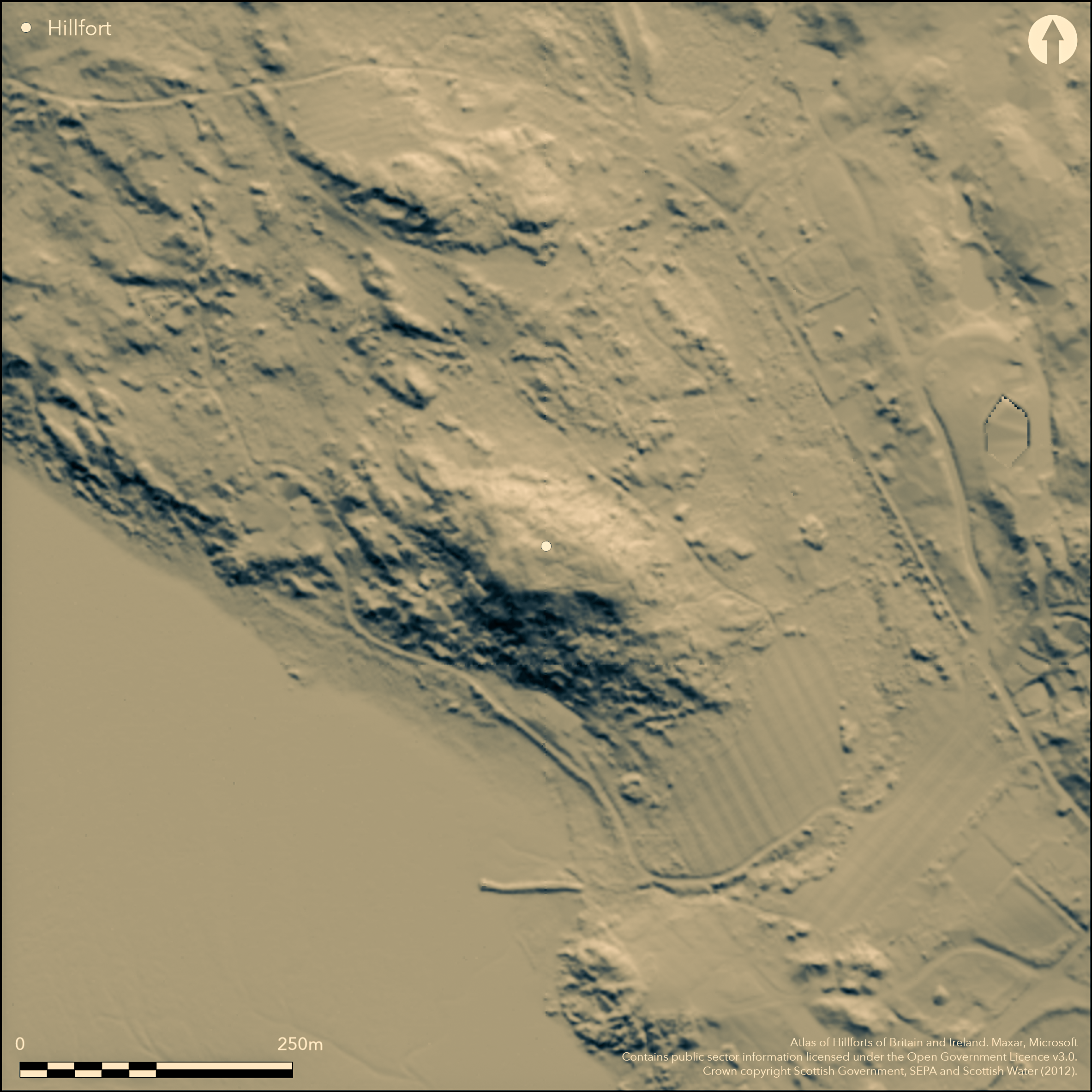
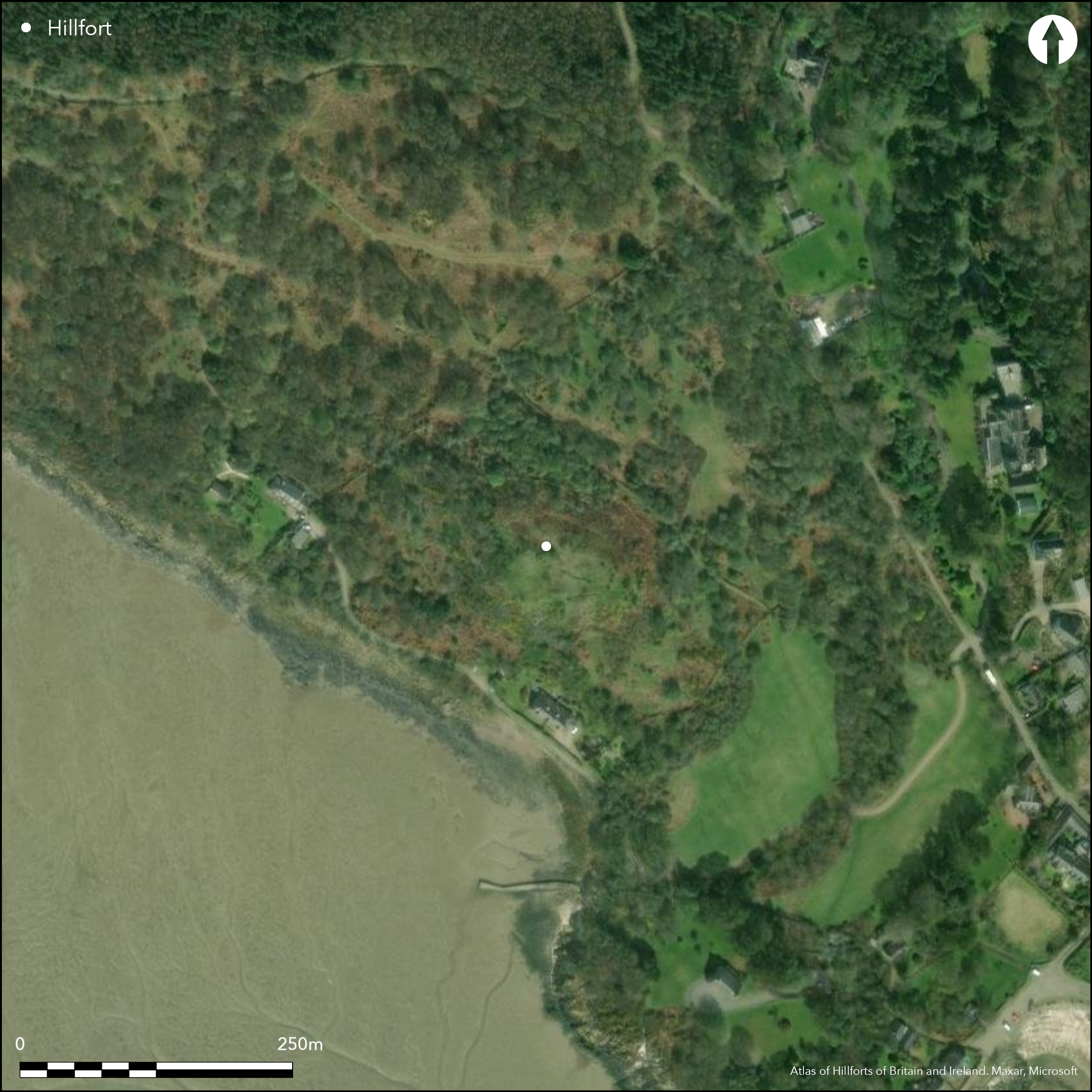
This fort occupies the summit of an irregular rocky hillock on the eastern shores of the Rough Firth. Shaped like a boot, with its toe pointing to the north, the irregular interior measures about 67m from NW to SE by a maximum of 32m transversely. The rampart can be traced round the margin of the summit, though it has largely collapsed into massive screes of rubble that can be detected on NE, S and W flanks of the hillock. Where excavated on the NE and S (see Laing & Longley 2006, 7-13), the rampart measures about 3.7m in thickness, and on the NE the scree of rubble on the slope below was over 1m deep; while most of this material denotes the massive scale of the rampart on the summit, it is also possible that it masks an outer rampart, particularly on the NE and W where other breaks of slope may indicate a second line of defence. No trace of an entrance can be seen and none was located in the excavations conducted here in 1913 (Curle 1914), 1973 and 1979 (Laing & Longley 2006). The excavations provided evidence of occupation in the form of hearths, bone and numerous artefacts (Laing & Longley 2006, 14-24) and there was also extensive evidence of metalworking, including iron, copper-alloy, gold and silver (Laing and Longley 2006, 25-74); a possible post built rectangular building was located but little evidence of floors or other structures. Finds include Mediterranean glass and pottery imports dating from the 6th and 7th centuries AD, and various moulds and manufactured artefacts of the same period. There are also five radiocarbon dates from rampart timbers with calibrated ranges spanning from the late 4th century to the early 7th century, but a sherd of E ware probably of early 6th century date and a fragment of 6th/7th century glass from pre-rampart contexts indicate that the defences were constructed in the latter part of this span, probably towards the end of the 6th century (Laing & Longley 2006, 24).
Citizen Science: ✗
Reliability of Data: Confirmed
Reliability of Interpretation: Confirmed
X: -423155 Y: 7336230 (EPSG: 3857)
Longitude: -3.801265982125483 Latitude: 54.86769024694301 (EPSG:4326)
Country: Scotland
Current County or Unitary Authority: Dumfries & Galloway
Historic County: Kirkcudbrightshire
Current Parish/Community/Council/Townland: Colvend And Southwick
None
| Extant | ✓ |
| Cropmark | ✗ |
| Likely Destroyed | ✗ |
None
| Woodland | ✗ |
| Commercial Forestry Plantation | ✗ |
| Parkland | ✗ |
| Pasture (Grazing) | ✗ |
| Arable | ✗ |
| Scrub/Bracken | ✓ |
| Bare Outcrop | ✗ |
| Heather/Moorland | ✗ |
| Heath | ✗ |
| Built-up | ✗ |
| Coastal Grassland | ✓ |
| Other | ✗ |
None
| Contour Fort | ✓ |
| Partial Contour Fort | ✗ |
| Promontory Fort | ✗ |
| Hillslope Fort | ✗ |
| Level Terrain Fort | ✗ |
| Marsh Fort | ✗ |
| Multiple Enclosure Fort | ✗ |
| Hilltop | ✗ |
| Coastal Promontory | ✗ |
| Inland Promontory | ✗ |
| Valley Bottom | ✗ |
| Knoll/Hillock/Outcrop | ✓ |
| Ridge | ✗ |
| Cliff/Plateau-edge/Scarp | ✗ |
| Hillslope | ✗ |
| Lowland | ✗ |
| Spur | ✗ |
Dominant Topographic Feature: None
| North | ✗ |
| Northeast | ✗ |
| East | ✗ |
| Southeast | ✗ |
| South | ✗ |
| Southwest | ✗ |
| West | ✗ |
| Northwest | ✗ |
| Level | ✓ |
Altitude: 35.0m
N/A
Artefacts and radiocarbon dates place this fort firmly in the early medieval period . Horn (Forthcoming) suggests hillfort start 550AD, end 700AD.
Reliability: A - High
| Pre 1200BC | ✗ |
| 1200BC - 800BC | ✗ |
| 800BC - 400BC | ✗ |
| 400BC - AD50 | ✗ |
| AD50 - AD400 | ✗ |
| AD400 - AD 800 | ✓ |
| Post AD800 | ✗ |
| Unknown | ✗ |
| Pre Hillfort: | None |
| Post Hillfort: | None |
| Artefactual: | Range of imported pottery and glass, and numerous mould fragments |
| C14: | Five dates from various contexts |
While Roy's Map (1747-55) annotates Mark Hill or its SW spur 'Moat', it is likely that this refers to the Mote of Mark, which is clearly discernible in the hillshade depiction to the S. The error is corrected on John Ainslie's map of the Stewartry of Kirkcudbright (1797), and in 1849-51 the site appears in greater detail on the 1st edition OS 6-inch map annotated 'Mark Moat (Vitrified Fort)' (Kirkcudbrightshire 1854, sheet 46). Having been noted by Rober Ridell in 1790 (Coles 1893, 93), it also appears in the Statistical Account for the parish (Stat Acct xvii,1796, 111), and in 1892 was surveyed by Frederick Coles (1893, 92-6, fig 2). A description was prepared by Alexander Curle for the County Inventory for The Stewartry (RCAHMS 1914, 71, no.120), and he returned in 1913 to mount an excavation (Curle 1914). RCAHMS revisited the fort in 1951, and the OS re-surveyed at 1:2500 in 1969. Further excavations were carried out under the direction of Lloyd Laing and David Longley in 1973 and 1979 (Laing & Longley 2006). The fort is now managed by the National Trust for Scotland.
| 1st Identified Map Depiction (1755): | Roy's Map (1747-55) |
| 1st Identified Written Reference (1790): | Robert Ridell 1790 'Observations on a vitrified fort in Galloway' cited in footnote by Coles 1893, 93 |
| Other (1796): | Noted (Stat Acct xvii,1796, 111) |
| Other (1851): | Named and annotated Vitrified Fort on the 1st edition OS 6-inch map (Kirkcudbrightshire 1854, sheet 46) |
| Earthwork Survey (1892): | Description and sketch-plan (Coles 1893, 92-6) |
| Other (1911): | Description (RCAHMS 1914, 71, no.120) |
| Excavation (1913): | By Alexander Curle (1914) |
| Other (1937): | Scheduled |
| Other (1951): | Description during RCAHMS Survey of Marginal Lands |
| Other (1969): | Resurveyed at 1:2500 by the OS |
| Excavation (1973): | Laing & Longley 2006 |
| Excavation (1979): | Laing & Longley 2006 |
Featureless on the surface, but post-built and stone founded structures revealed by excavation
None
| None | ✓ |
| Spring | ✗ |
| Stream | ✗ |
| Pool | ✗ |
| Flush | ✗ |
| Well | ✗ |
| Other | ✗ |
None
| No Known Features | ✓ |
| Round Stone Structures | ✗ |
| Rectangular Stone Structures | ✗ |
| Curvilinear Platforms | ✗ |
| Other Roundhouse Evidence | ✗ |
| Pits | ✗ |
| Quarry Hollows | ✗ |
| Other | ✗ |
Hearths
| No Known Excavation | ✗ |
| Pits | ✓ |
| Postholes | ✓ |
| Roundhouses | ✗ |
| Rectangular Structures | ✓ |
| Roads/Tracks | ✗ |
| Quarry Hollows | ✗ |
| Other | ✓ |
| Nothing Found | ✗ |
None
| No Known Geophysics | ✓ |
| Pits | ✗ |
| Roundhouses | ✗ |
| Rectangular Structures | ✗ |
| Roads/Tracks | ✗ |
| Quarry Hollows | ✗ |
| Other | ✗ |
| Nothing Found | ✗ |
Including pottery and glass imports
| No Known Finds | ✗ |
| Pottery | ✓ |
| Metal | ✓ |
| Metalworking | ✓ |
| Human Bones | ✗ |
| Animal Bones | ✓ |
| Lithics | ✓ |
| Environmental | ✗ |
| Other | ✓ |
None
| APs Not Checked | ✗ |
| None | ✓ |
| Roundhouses | ✗ |
| Rectangular Structures | ✗ |
| Pits | ✗ |
| Postholes | ✗ |
| Roads/Tracks | ✗ |
| Other | ✗ |
None known
| 0: | The whole circuit is heavily degraded |
| 2: | No clearly defined entrance has been located |
Guard Chambers: ✗
Chevaux de Frise: ✗
Continuous timber-laced wall round the summit
| Area 1: | 0.16ha. |
| Total: | 0.16ha. |
Total Footprint Area: Noneha.
None
| ✗ | None |
| ✓ | Possibly an outer line on the N, S and W masked by fallen rubble from the summit. |
| NE Quadrant: | 1 |
| SE Quadrant: | 1 |
| SW Quadrant: | 1 |
| NW Quadrant: | 1 |
| Total: | 1 |
| Partial Univallate | ✗ |
| Univallate | ✓ |
| Partial Bivallate | ✗ |
| Bivallate | ✗ |
| Partial Multivallate | ✗ |
| Multivallate | ✗ |
| Unknown | ✗ |
| Partial Univallate | ✗ |
| Univallate | ✗ |
| Partial Bivallate | ✗ |
| Bivallate | ✗ |
| Partial Multivallate | ✗ |
| Multivallate | ✗ |
None
| None | ✗ |
| Earthen Bank | ✗ |
| Stone Wall | ✗ |
| Rubble | ✓ |
| Wall-walk | ✗ |
| Evidence of Timber | ✗ |
| Vitrification | ✓ |
| Other Burning | ✗ |
| Palisade | ✗ |
| Counter Scarp Bank | ✗ |
| Berm | ✗ |
| Unfinished | ✗ |
| Other | ✗ |
None
| None | ✗ |
| Earthen Bank | ✗ |
| Stone Wall | ✓ |
| Murus Duplex | ✗ |
| Timber-framed | ✗ |
| Timber-laced | ✓ |
| Vitrification | ✓ |
| Other Burning | ✗ |
| Palisade | ✗ |
| Counter Scarp Bank | ✗ |
| Berm | ✗ |
| Unfinished | ✗ |
| No Known Excavation | ✗ |
| Other | ✗ |
| ✗ | None |
| ✗ | None |
Number of Ditches: None
| ✗ | None |
Coles, F R (1893) 'The motes, forts, and doons in the east and west divisions of the Stewartry of Kirkcudbright', Proc Soc Antiq Scot 27, 92-182
Curle, A O (1914) 'Report on the excavation in September 1913, of a vitrified fort at Rockcliffe, Dalbeattie, known as the Mote of Mark', Proc Soc Antiq Scot 48, 125-68
Feachem, R (1963) A guide to prehistoric Scotland, London (p 129)
Horn, J. Forthcoming. The dating of hillforts in Britain and Ireland. Unpublished PhD thesis, University of Edinburgh.
Laing, L & Longley, D 2006 The Mote of Mark: A Dark Age Hillfort in South-West Scotland. Oxbow Books, Oxford
RCAHMS (1914) The Royal Commission on the Ancient and Historical Monuments and Constructions of Scotland. Fifth report and inventory of monuments and constructions in Galloway, II, county of the Stewartry of Kirkcudbright, Edinburgh
Statistical Account of Scotland: Drawn up from the Communications of the Ministers of the Different Parishes (Sinclair, J ed), 1791-99
Atlas of Hillforts:
Wikidata:
This work is licensed under CC BY-SA 4.0![]()
![]()
![]() and should be cited as:
and should be cited as:
Lock, Gary and Ralston, Ian. 2024. Atlas of Hillforts of Britain and Ireland. Available at: https://hillforts.arch.ox.ac.uk
Document Version 1.1